Westwood (West Wood) neighborhood in Wooster, Ohio (OH), 44691 detailed profile
Settings
X


Business Search - 14 Million verified businesses
Area: 8.547 square miles
Population: 5,307
Population density:
| Westwood (West Wood): | 621 people per square mile |
| Wooster: | 1,880 people per square mile |

- 5,25081.3%White
- 75511.7%Black
- 2083.2%Hispanic or Latino
- 1472.3%American Indian
- 410.6%Two or more races
- 350.5%Some other race
- 220.3%Asian

Distribution of median household income
![Distribution of median household income]()
- 162Less than $10,000
- 477$10,000 to $19,999
- 193$20,000 to $29,999
- 304$30,000 to $39,999
- 284$40,000 to $49,999
- 163$50,000 to $59,999
- 176$60,000 to $74,999
- 404$75,000 to $99,999
- 323$100,000 to $124,999
- 583$125,000 to $149,999
- 251$150,000 to $199,999
- 166$200,000 or more

Distribution of owner-occupied house/condo value
![Distribution of owner-occupied house/condo value]()
- 299Less than $50,000
- 329$50,000 to $99,999
- 2,567$100,000 to $149,999
- 444$150,000 to $199,999
- 1,116$200,000 to $249,999
- 719$250,000 to $299,999
- 687$300,000 to $399,999
- 318$400,000 to $499,999
- 232$500,000 to $749,999
- 8$750,000 to $999,999
- 8$1,000,000 or more

Distribution of rent paid by renters
![Distribution of rent paid by renters]()
- 860Less than $100
- 10$100 to $199
- 332$200 to $299
- 824$300 to $399
- 1,607$400 to $499
- 333$500 to $599
- 261$600 to $699
- 360$700 to $799
- 65$800 to $899
- 357$900 to $999
- 789$1,000 to $1,249
- 6$1,250 to $1,499
- 204$1,500 to $1,999
- 28$2,000 or more

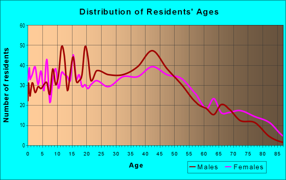
| Males: | 2,813 |
| Females: | 2,493 |
Males:
| This neighborhood: | 40.5 years |
| Whole city: | 39.6 years |
| This neighborhood: | 47.9 years |
| Whole city: | 38.3 years |
Average household size:
| Westwood (West Wood): | 2.2 people |
| Wooster: | 2.2 people |
Percentage of family households:
| Westwood (West Wood): | 38.1% |
| Wooster: | 40.4% |
| Here: | 39.6% |
| Wooster: | 42.8% |
Percentage of married-couple families with children (among all households):
| Westwood (West Wood): | 32.0% |
| Wooster: | 27.6% |
Percentage of single-mother households (among all households):
| Westwood (West Wood): | 13.3% |
| Wooster: | 8.4% |
Percentage of never married males 15 years old and over:
Percentage of never married females 15 years old and over:
| Westwood (West Wood): | 19.9% |
| Wooster: | 18.0% |
Percentage of never married females 15 years old and over:
| Westwood (West Wood): | 8.1% |
| city: | 19.7% |
Percentage of people that speak English not well or not at all:
| Westwood (West Wood): | 0.0% |
| Wooster: | 0.2% |
Percentage of people born in this state:
Percentage of people born in another U.S. state:
Percentage of native residents but born outside the U.S.:
Percentage of foreign born residents:
| Here: | 86.2% |
| Wooster: | 72.1% |
Percentage of people born in another U.S. state:
| Westwood (West Wood): | 13.1% |
| Wooster: | 22.5% |
Percentage of native residents but born outside the U.S.:
| Here: | 0.8% |
| city: | 0.6% |
Percentage of foreign born residents:
| Here: | 0.7% |
| Wooster: | 4.8% |

Owner-occupied
Renter-occupied


- Rooms in owner-occupied houses and condos in Westwood <
> - 01 room
- 02 rooms
- 33 rooms
- 174 rooms
- 1725 rooms
- 2616 rooms
- 4847 rooms
- 2078 rooms
- 3689+ rooms

- Rooms in renter-occupied apartments in Westwood <
> - 6831 room
- 152 rooms
- 2953 rooms
- 3574 rooms
- 1015 rooms
- 696 rooms
- 4707 rooms
- 538 rooms
- 99+ rooms
Owner-occupied
Renter-occupied

- Bedrooms in owner-occupied houses and condos in Westwood <
> - 0no bedroom
- 151 bedroom
- 1172 bedrooms
- 1,0723 bedrooms
- 8014 bedrooms
- 3155+ bedrooms

- Bedrooms in renter-occupied apartments in Westwood <
> - 683no bedroom
- 2,2211 bedroom
- 4662 bedrooms
- 1563 bedrooms
- 1284 bedrooms
- 125+ bedrooms
Average number of cars or other vehicles available in houses/condos:
Average number of cars or other vehicles available in apartments:
| This neighborhood: | |
| Wooster: |
Average number of cars or other vehicles available in apartments:
| Here: | 1.3 |
| city: | 1.1 |
Percentage of units with a mortgage:
| Westwood (West Wood): | 52.8% |
| Wooster: | 58.3% |

- Year house built in Westwood <
> - 62020 or later
- 192010 to 2019
- 8432000 to 2009
- 3331990 to 1999
- 2161980 to 1989
- 3681970 to 1979
- 3591960 to 1969
- 4641950 to 1959
- 1671940 to 1949
- 4721939 or earlier

City-data.com crime index for city in 2020 (higher means more crime):
| City: | 216.1 |
| U.S. average: | 219.5 |
Travel time to work (commute)
![Travel time to work (commute)]()
- 129Less than 5 minutes
- 1075 to 9 minutes
- 51210 to 14 minutes
- 25215 to 19 minutes
- 8820 to 24 minutes
- 1625 to 29 minutes
- 11630 to 34 minutes
- 4535 to 39 minutes
- 3640 to 44 minutes
- 23145 to 59 minutes
- 6260 to 89 minutes
- 2390 or more minutes

Means of transportation to work
![Means of transportation to work]()
- 90.0%2,308Drove a car alone
- 5.4%138Carpooled
- 92.2%2,364Taxi
- 3.6%92Motorcycle
- 0.2%5Bicycle
- 21.4%550Walked
- 0.2%5Other means
- 3.5%89Worked at home

Time leaving home to go to work
![Time leaving home to go to work]()
- 1212:00 a.m. to 4:59 a.m.
- 315:00 a.m. to 5:29 a.m.
- 1335:30 a.m. to 5:59 a.m.
- 1056:00 a.m. to 6:29 a.m.
- 1566:30 a.m. to 6:59 a.m.
- 2877:00 a.m. to 7:29 a.m.
- 1407:30 a.m. to 7:59 a.m.
- 1358:00 a.m. to 8:29 a.m.
- 1228:30 a.m. to 8:59 a.m.
- 309:00 a.m. to 9:59 a.m.
- 810:00 a.m. to 10:59 a.m.
- 1011:00 a.m. to 11:59 a.m.
- 15512:00 p.m. to 3:59 p.m.
- 1984:00 p.m. to 11:59 p.m.

Occupations of males:
- Percentage of males in management occupations (except farmers):
Here: 11.6% city: 9.9%
- Percentage of males in computer and mathematical occupations:
Here: 4.9% city: 5.0%
- Percentage of males in legal occupations:
Here: 1.7% city: 0.7%
- Percentage of males in education, training, and library occupations:
Here: 1.1% city: 5.2%
- Percentage of males in arts, design, entertainment, sports, and media occupations:
Here: 1.4% city: 2.2%
- Percentage of males in service occupations:
Here: 24.8% city: 13.2%
- Percentage of males in sales and office occupations:
Here: 7.3% city: 12.1%
- Percentage of males in construction, extraction, and maintenance occupations:
Here: 5.9% city: 2.9%
- Percentage of males in production occupations:
Here: 22.2% city: 12.4%
- Percentage of males in transportation occupations:
Here: 8.1% city: 5.6%
- Percentage of males in material moving occupations:
Here: 7.7% city: 10.2%
Occupations of females:
- Percentage of females in management occupations (except farmers):
Here: 8.0% city: 4.3%
- Percentage of females in business and financial operations occupations:
Here: 4.6% city: 2.3%
- Percentage of females in community and social services occupations:
Here: 4.5% city: 2.3%
- Percentage of females in education, training, and library occupations:
Here: 8.3% city: 11.3%
- Percentage of females in healthcare practitioners and technical occupations:
Here: 13.7% city: 11.4%
- Percentage of females in service occupations:
Here: 14.3% city: 20.5%
- Percentage of females in sales and office occupations:
Here: 22.8% city: 25.3%
- Percentage of females in construction, extraction, and maintenance occupations:
Here: 2.7% city: 0.0%
- Percentage of females in production occupations:
Here: 18.2% city: 10.4%
- Percentage of females in material moving occupations:
Here: 2.7% city: 4.6%
Education in this neighborhood (subdivision or community):
- Percentage of people 3 years and older in K-12 schools:
Westwood (West Wood): 28.3% Wooster: 13.5%
- Percentage of people 3 years and older in undergraduate colleges:
Westwood (West Wood): 6.5% Wooster: 13.3%
- Percentage of people 3 years and older in grad. or professional schools:
Westwood (West Wood): 0.5% Wooster: 0.3%
- Percentage of students K-12 enrolled in private schools:
Westwood (West Wood): 108.5% Wooster: 9.3%
Percentage of population below poverty level:
| Westwood (West Wood): | 12.1% |
| Wooster: | 10.8% |
Percentage of married-couple families with both working:
| Westwood (West Wood): | 266.4% |
| Wooster: | 75.9% |

- 50.1%Utility gas
- 17.7%Electricity
- 15.2%Bottled, tank, or LP gas
- 6.1%Wood
- 5.6%Fuel oil, kerosene, etc.
- 2.2%Other fuel
- 2.0%No fuel used
- 1.1%Solar energy
Highways in this neighborhood:
Lincoln Way (US Rte 250, US Rte 30)
Length: 7.55 miles
Directions: E-W, SE-NW
Address range: 1400 to 1699
Directions: E-W, SE-NW
Address range: 1400 to 1699
S Columbus Rd (State Rte 3)
Length: 6.19 miles
Directions: E-W, N-S, SW-NE
Address range: 100 to 3183
Directions: E-W, N-S, SW-NE
Address range: 100 to 3183
Blachleyville Rd (State Rte 95)
Length: 2.49 miles
Direction: E-W
Address range: 900 to 2999
Direction: E-W
Address range: 900 to 2999
Old Lincoln Way W (State Rte 302)
Length: 2.02 miles
Direction: E-W
Address range: 420 to 2199
Direction: E-W
Address range: 420 to 2199
State Rte 302 (S Bever St)
Length: 0.32 miles
Direction: N-S
Address range: 150 to 440
Direction: N-S
Address range: 150 to 440
State Rte 302 (Lattasburg Rd)
Length: 0.32 miles
Direction: SE-NW
Direction: SE-NW
Shreve Rd (State Rte 226)
Length: 0.07 miles
Direction: N-S
Direction: N-S
Roads and streets:
Co Hwy 139 (Heyl Rd)
Length: 2.82 miles
Directions: E-W, SE-NW
Address range: 600 to 2999
Directions: E-W, SE-NW
Address range: 600 to 2999
Old Columbus Rd (Co Hwy 3a)
Length: 2.61 miles
Directions: E-W, SE-NW, SW-NE
Address range: 1000 to 2249
Directions: E-W, SE-NW, SW-NE
Address range: 1000 to 2249
S Smyser Rd (Twp Hwy 35)
Length: 1.87 miles
Directions: N-S, SE-NW
Address range: 1146 to 3155
Directions: N-S, SE-NW
Address range: 1146 to 3155
W Liberty St
Length: 1.25 miles
Directions: E-W, SE-NW
Address range: 100 to 1095
Directions: E-W, SE-NW
Address range: 100 to 1095
Old Mansfield Rd (Twp Hwy 46)
Length: 1.09 miles
Directions: E-W, N-S, SW-NE
Address range: 1351 to 1899
Directions: E-W, N-S, SW-NE
Address range: 1351 to 1899
Co Hwy 30A (W Old Lincoln Way)
Length: 1.04 miles
Direction: E-W
Address range: 160 to 2897
Direction: E-W
Address range: 160 to 2897
Twp Hwy 186 (Fry Rd)
Length: 1.02 miles
Direction: N-S
Address range: 201 to 499
Direction: N-S
Address range: 201 to 499
Batdorf Rd (Twp Hwy 177)
Length: 0.90 miles
Direction: N-S
Address range: 1700 to 2749
Direction: N-S
Address range: 1700 to 2749
Barnes Dr
Length: 0.89 miles
Directions: E-W, N-S, SE-NW, SW-NE
Address range: 1300 to 2099
Directions: E-W, N-S, SE-NW, SW-NE
Address range: 1300 to 2099
Twp Hwy 192 (Mc Afee Rd)
Length: 0.88 miles
Directions: E-W, SE-NW
Directions: E-W, SE-NW
Twp Hwy 181 (Wile Rd)
Length: 0.80 miles
Directions: E-W, SE-NW
Address range: 2100 to 2999
Directions: E-W, SE-NW
Address range: 2100 to 2999
W Henry St
Length: 0.68 miles
Directions: E-W, SE-NW
Address range: 100 to 599
Directions: E-W, SE-NW
Address range: 100 to 599
Venture Blvd
Length: 0.65 miles
Directions: N-S, SW-NE
Address range: 300 to 1099
Directions: N-S, SW-NE
Address range: 300 to 1099
W Larwill St
Length: 0.65 miles
Direction: E-W
Address range: 100 to 599
Direction: E-W
Address range: 100 to 599
W North St
Length: 0.61 miles
Direction: E-W
Address range: 100 to 599
Direction: E-W
Address range: 100 to 599
Clover St
Length: 0.54 miles
Directions: E-W, SE-NW
Address range: 1200 to 1575
Directions: E-W, SE-NW
Address range: 1200 to 1575
Meadowbrook Dr
Length: 0.53 miles
Directions: E-W, N-S, SE-NW
Address range: 2600 to 3099
Directions: E-W, N-S, SE-NW
Address range: 2600 to 3099
Dale Dr
Length: 0.52 miles
Directions: E-W, SE-NW
Address range: 800 to 1199
Directions: E-W, SE-NW
Address range: 800 to 1199
Co Hwy 176 (Prairie Ln)
Length: 0.52 miles
Direction: N-S
Address range: 1200 to 1831
Direction: N-S
Address range: 1200 to 1831
W South St
Length: 0.51 miles
Direction: E-W
Address range: 100 to 499
Direction: E-W
Address range: 100 to 499
Saybolt Ave
Length: 0.47 miles
Direction: E-W
Address range: 300 to 699
Direction: E-W
Address range: 300 to 699
N Grant St
Length: 0.47 miles
Direction: N-S
Address range: 100 to 599
Direction: N-S
Address range: 100 to 599
Allen Dr
Length: 0.47 miles
Directions: E-W, SW-NE
Address range: 800 to 1199
Directions: E-W, SW-NE
Address range: 800 to 1199
N Walnut St
Length: 0.47 miles
Direction: N-S
Address range: 100 to 599
Direction: N-S
Address range: 100 to 599
Spruce St
Length: 0.46 miles
Directions: N-S, SW-NE
Address range: 519 to 1099
Directions: N-S, SW-NE
Address range: 519 to 1099
Co Hwy 174 (Columbus Ave Exn)
Length: 0.45 miles
Directions: N-S, SE-NW
Address range: 900 to 1499
Directions: N-S, SE-NW
Address range: 900 to 1499
Burnetts Corner Rd (Twp Hwy 442)
Length: 0.41 miles
Directions: E-W, N-S, SE-NW, SW-NE
Address range: 1700 to 2099
Directions: E-W, N-S, SE-NW, SW-NE
Address range: 1700 to 2099
N Market St
Length: 0.41 miles
Direction: N-S
Address range: 100 to 544
Direction: N-S
Address range: 100 to 544
Earl Ct
Length: 0.41 miles
Directions: E-W, SE-NW, SW-NE
Directions: E-W, SE-NW, SW-NE
Kemrow St
Length: 0.41 miles
Direction: E-W
Address range: 500 to 799
Direction: E-W
Address range: 500 to 799
Indian Run Dr
Length: 0.40 miles
Directions: E-W, N-S, SE-NW
Address range: 2800 to 3099
Directions: E-W, N-S, SE-NW
Address range: 2800 to 3099
S Buckeye St
Length: 0.40 miles
Direction: N-S
Address range: 200 to 600
Direction: N-S
Address range: 200 to 600
Silver Rd (Twp Hwy 4)
Length: 0.38 miles
Directions: E-W, SE-NW, SW-NE
Address range: 1480 to 2343
Directions: E-W, SE-NW, SW-NE
Address range: 1480 to 2343
Timothy Pl
Length: 0.37 miles
Directions: E-W, N-S, SW-NE
Address range: 2500 to 2899
Directions: E-W, N-S, SW-NE
Address range: 2500 to 2899
S Grant St
Length: 0.36 miles
Directions: E-W, N-S, SE-NW
Address range: 100 to 499
Directions: E-W, N-S, SE-NW
Address range: 100 to 499
Twp Hwy 441 (Branstetter St)
Length: 0.36 miles
Direction: N-S
Address range: 100 to 399
Direction: N-S
Address range: 100 to 399
Jones Ave
Length: 0.34 miles
Directions: E-W, SW-NE
Address range: 1400 to 1572
Directions: E-W, SW-NE
Address range: 1400 to 1572
Western Dr
Length: 0.33 miles
Direction: E-W
Address range: 600 to 799
Direction: E-W
Address range: 600 to 799
Le Ann St
Length: 0.33 miles
Directions: E-W, SE-NW
Address range: 759 to 998
Directions: E-W, SE-NW
Address range: 759 to 998
S Walnut St
Length: 0.32 miles
Direction: N-S
Address range: 100 to 499
Direction: N-S
Address range: 100 to 499
Westwood Cir
Length: 0.31 miles
Directions: E-W, N-S, SE-NW, SW-NE
Address range: 1638 to 1746
Directions: E-W, N-S, SE-NW, SW-NE
Address range: 1638 to 1746
S Market St
Length: 0.31 miles
Direction: N-S
Address range: 100 to 499
Direction: N-S
Address range: 100 to 499
Center Dr
Length: 0.31 miles
Directions: E-W, N-S, SW-NE
Address range: 1230 to 1329
Directions: E-W, N-S, SW-NE
Address range: 1230 to 1329
Twp Hwy 455 (Cherry Ln)
Length: 0.30 miles
Directions: N-S, SE-NW
Address range: 108 to 183
Directions: N-S, SE-NW
Address range: 108 to 183
Frank Dr
Length: 0.29 miles
Directions: N-S, SE-NW, SW-NE
Address range: 1100 to 1499
Directions: N-S, SE-NW, SW-NE
Address range: 1100 to 1499
Mulberry St
Length: 0.29 miles
Direction: E-W
Address range: 100 to 399
Direction: E-W
Address range: 100 to 399
Summerset Dr
Length: 0.28 miles
Directions: E-W, N-S, SE-NW, SW-NE
Address range: 1000 to 1199
Directions: E-W, N-S, SE-NW, SW-NE
Address range: 1000 to 1199
Emerick St
Length: 0.24 miles
Direction: N-S
Address range: 400 to 599
Direction: N-S
Address range: 400 to 599
N Columbus Ave
Length: 0.23 miles
Direction: N-S
Address range: 100 to 347
Direction: N-S
Address range: 100 to 347
W Bowman St
Length: 0.23 miles
Direction: E-W
Address range: 200 to 398
Direction: E-W
Address range: 200 to 398
Sunnyview Ln
Length: 0.23 miles
Directions: E-W, N-S, SE-NW, SW-NE
Address range: 1100 to 1298
Directions: E-W, N-S, SE-NW, SW-NE
Address range: 1100 to 1298
Greenbriar Ln
Length: 0.23 miles
Direction: N-S
Address range: 2400 to 2713
Direction: N-S
Address range: 2400 to 2713
Bixler Rd
Length: 0.22 miles
Direction: E-W
Address range: 131 to 139
Direction: E-W
Address range: 131 to 139
E Henry St
Length: 0.22 miles
Direction: E-W
Address range: 100 to 299
Direction: E-W
Address range: 100 to 299
E South St
Length: 0.22 miles
Direction: E-W
Address range: 100 to 299
Direction: E-W
Address range: 100 to 299
Gallo Dr
Length: 0.22 miles
Directions: E-W, SE-NW
Address range: 1200 to 1399
Directions: E-W, SE-NW
Address range: 1200 to 1399
Lincoln Way Farms
Length: 0.21 miles
Direction: E-W
Direction: E-W
Mowrer St
Length: 0.21 miles
Directions: E-W, SE-NW
Address range: 1452 to 1499
Directions: E-W, SE-NW
Address range: 1452 to 1499
Vanover St
Length: 0.20 miles
Directions: N-S, SE-NW
Directions: N-S, SE-NW
Chestnut Ct
Length: 0.19 miles
Direction: N-S
Direction: N-S
Earl St
Length: 0.19 miles
Directions: N-S, SW-NE
Address range: 2400 to 2599
Directions: N-S, SW-NE
Address range: 2400 to 2599
Spruce St Exd
Length: 0.18 miles
Directions: N-S, SE-NW, SW-NE
Address range: 1400 to 1599
Directions: N-S, SE-NW, SW-NE
Address range: 1400 to 1599
Wilma Dr
Length: 0.18 miles
Direction: N-S
Address range: 2555 to 2650
Direction: N-S
Address range: 2555 to 2650
W Vine St
Length: 0.18 miles
Direction: E-W
Address range: 100 to 399
Direction: E-W
Address range: 100 to 399
Jane St
Length: 0.17 miles
Direction: N-S
Address range: 2500 to 2699
Direction: N-S
Address range: 2500 to 2699
Madison Ave
Length: 0.17 miles
Direction: SE-NW
Address range: 500 to 699
Direction: SE-NW
Address range: 500 to 699
Graceland Way
Length: 0.17 miles
Directions: N-S, SE-NW
Address range: 2577 to 2699
Directions: N-S, SE-NW
Address range: 2577 to 2699
Woodland Ave
Length: 0.16 miles
Direction: N-S
Address range: 400 to 518
Direction: N-S
Address range: 400 to 518
Curtwood Dr
Length: 0.15 miles
Direction: E-W
Address range: 900 to 1053
Direction: E-W
Address range: 900 to 1053
Shamrock Way
Length: 0.15 miles
Directions: N-S, SE-NW
Address range: 2400 to 2840
Directions: N-S, SE-NW
Address range: 2400 to 2840
Mark St
Length: 0.13 miles
Direction: N-S
Address range: 2500 to 2599
Direction: N-S
Address range: 2500 to 2599
Park Dr
Length: 0.13 miles
Direction: N-S
Address range: 400 to 499
Direction: N-S
Address range: 400 to 499
Wood St
Length: 0.13 miles
Directions: N-S, SE-NW
Address range: 299 to 499
Directions: N-S, SE-NW
Address range: 299 to 499
Ohio St
Length: 0.13 miles
Direction: E-W
Address range: 118 to 212
Direction: E-W
Address range: 118 to 212
John St
Length: 0.13 miles
Direction: N-S
Address range: 2500 to 2599
Direction: N-S
Address range: 2500 to 2599
Mc Donald St
Length: 0.12 miles
Direction: N-S
Address range: 400 to 498
Direction: N-S
Address range: 400 to 498
Lawn St
Length: 0.12 miles
Direction: E-W
Address range: 300 to 399
Direction: E-W
Address range: 300 to 399
Derick St
Length: 0.11 miles
Direction: N-S
Address range: 2500 to 2599
Direction: N-S
Address range: 2500 to 2599
Leroy St
Length: 0.11 miles
Direction: E-W
Address range: 155 to 161
Direction: E-W
Address range: 155 to 161
Lois Ave
Length: 0.11 miles
Directions: E-W, SE-NW, SW-NE
Address range: 800 to 899
Directions: E-W, SE-NW, SW-NE
Address range: 800 to 899
Grosjean Rd
Length: 0.11 miles
Direction: E-W
Direction: E-W
Louise Ave
Length: 0.10 miles
Direction: E-W
Direction: E-W
E Vine St
Length: 0.10 miles
Direction: E-W
Address range: 100 to 199
Direction: E-W
Address range: 100 to 199
Baughman
Length: 0.10 miles
Direction: N-S
Direction: N-S
Elm St
Length: 0.10 miles
Directions: N-S, SW-NE
Directions: N-S, SW-NE
Clark Ave
Length: 0.09 miles
Direction: E-W
Address range: 200 to 241
Direction: E-W
Address range: 200 to 241
Arnold Ct
Length: 0.09 miles
Direction: E-W
Address range: 312 to 324
Direction: E-W
Address range: 312 to 324
Clinton
Length: 0.09 miles
Direction: E-W
Direction: E-W
Mc Guire St
Length: 0.09 miles
Direction: E-W
Address range: 500 to 599
Direction: E-W
Address range: 500 to 599
Glenn Ave
Length: 0.08 miles
Direction: E-W
Address range: 600 to 699
Direction: E-W
Address range: 600 to 699
Chippewa
Length: 0.08 miles
Direction: SW-NE
Direction: SW-NE
Julia Cir
Length: 0.08 miles
Directions: N-S, SW-NE
Address range: 1200 to 1399
Directions: N-S, SW-NE
Address range: 1200 to 1399
Ruth Dr
Length: 0.08 miles
Directions: N-S, SE-NW
Address range: 1554 to 1625
Directions: N-S, SE-NW
Address range: 1554 to 1625
Locust Dr
Length: 0.07 miles
Direction: SE-NW
Address range: 1700 to 1799
Direction: SE-NW
Address range: 1700 to 1799
Myers Dr
Length: 0.06 miles
Directions: N-S, SE-NW
Address range: 1601 to 1640
Directions: N-S, SE-NW
Address range: 1601 to 1640
Milton
Length: 0.06 miles
Directions: N-S, SE-NW
Directions: N-S, SE-NW
Canal St
Length: 0.06 miles
Direction: E-W
Direction: E-W
Mechanicsburg Rd
Length: 0.05 miles
Direction: SE-NW
Address range: 1220 to 1239
Direction: SE-NW
Address range: 1220 to 1239
Wooster
Length: 0.04 miles
Direction: SW-NE
Direction: SW-NE
Oak Hill Rd
Length: 0.03 miles
Direction: N-S
Address range: 400 to 441
Direction: N-S
Address range: 400 to 441
Railroad features:
Baltimore and Ohio RR
Length: 6.23 miles
Directions: E-W, N-S, SE-NW, SW-NE
Directions: E-W, N-S, SE-NW, SW-NE
Conrail RR
Length: 1.64 miles
Directions: N-S, SW-NE
Directions: N-S, SW-NE
Other features:
Killbuck Crk
Length: 4.22 miles
Directions: E-W, N-S, SE-NW, SW-NE
Directions: E-W, N-S, SE-NW, SW-NE
Christmas Run
Length: 1.76 miles
Directions: E-W, N-S, SE-NW, SW-NE
Directions: E-W, N-S, SE-NW, SW-NE
Clear Crk
Length: 1.24 miles
Directions: E-W, N-S, SE-NW, SW-NE
Directions: E-W, N-S, SE-NW, SW-NE
Apple Crk
Length: 0.88 miles
Directions: E-W, N-S, SW-NE
Directions: E-W, N-S, SW-NE