Weber Ranch neighborhood in Stockton, California (CA), 95210, 95212 detailed profile
Settings
X


Business Search - 14 Million verified businesses
Area: 2.556 square miles
Population: 15,014
Population density:
| Weber Ranch: | 5,875 people per square mile |
| Stockton: | 5,882 people per square mile |

- 5,62836.0%Hispanic or Latino
- 4,51428.8%Asian
- 2,38815.3%White
- 1,96512.6%Black
- 7765.0%Two or more races
- 3612.3%Some other race
- 200.1%Native Hawaiian and Other
Pacific Islander

Distribution of median household income
![Distribution of median household income]()
- 635Less than $10,000
- 380$10,000 to $19,999
- 520$20,000 to $29,999
- 548$30,000 to $39,999
- 312$40,000 to $49,999
- 514$50,000 to $59,999
- 460$60,000 to $74,999
- 528$75,000 to $99,999
- 267$100,000 to $124,999
- 141$125,000 to $149,999
- 623$150,000 to $199,999
- 208$200,000 or more

Distribution of owner-occupied house/condo value
![Distribution of owner-occupied house/condo value]()
- 391Less than $50,000
- 414$50,000 to $99,999
- 339$100,000 to $149,999
- 164$150,000 to $199,999
- 393$200,000 to $249,999
- 652$250,000 to $299,999
- 780$300,000 to $399,999
- 469$400,000 to $499,999
- 166$500,000 to $749,999
- 38$750,000 to $999,999
- 60$1,000,000 or more

Distribution of rent paid by renters
![Distribution of rent paid by renters]()
- 145$100 to $199
- 83$200 to $299
- 105$400 to $499
- 77$500 to $599
- 221$700 to $799
- 327$800 to $899
- 349$900 to $999
- 1,301$1,000 to $1,249
- 342$1,250 to $1,499
- 229$1,500 to $1,999
- 350$2,000 or more

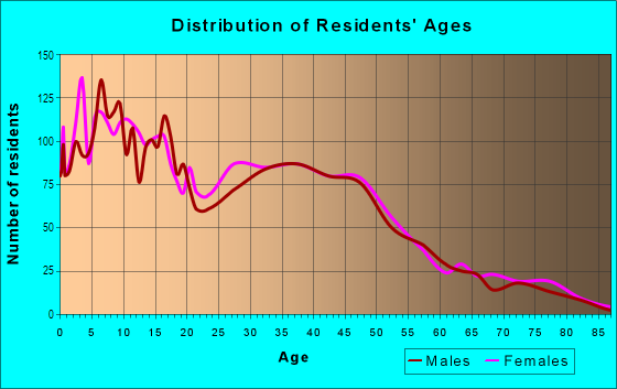
| Males: | 7,177 |
| Females: | 7,837 |
Males:
| This neighborhood: | 37.9 years |
| Whole city: | 33.4 years |
| This neighborhood: | 37.6 years |
| Whole city: | 35.2 years |
Average household size:
| Weber Ranch: | 6.1 people |
| Stockton: | 3.2 people |
Percentage of family households:
| Weber Ranch: | 53.2% |
| Stockton: | 51.0% |
| Here: | 39.1% |
| Stockton: | 42.0% |
Percentage of married-couple families with children (among all households):
| Weber Ranch: | 16.5% |
| Stockton: | 19.2% |
Percentage of single-mother households (among all households):
| Weber Ranch: | 15.8% |
| Stockton: | 9.1% |
Percentage of never married males 15 years old and over:
Percentage of never married females 15 years old and over:
| Weber Ranch: | 17.7% |
| Stockton: | 21.6% |
Percentage of never married females 15 years old and over:
| Weber Ranch: | 21.9% |
| city: | 19.3% |
Percentage of people that speak English not well or not at all:
| Weber Ranch: | 8.9% |
| Stockton: | 12.0% |
Percentage of people born in this state:
Percentage of people born in another U.S. state:
Percentage of native residents but born outside the U.S.:
Percentage of foreign born residents:
| Here: | 61.1% |
| Stockton: | 66.1% |
Percentage of people born in another U.S. state:
| Weber Ranch: | 11.2% |
| Stockton: | 7.2% |
Percentage of native residents but born outside the U.S.:
| Here: | 1.1% |
| city: | 1.5% |
Percentage of foreign born residents:
| Here: | 26.7% |
| Stockton: | 25.2% |

Owner-occupied
Renter-occupied


- Rooms in owner-occupied houses and condos in Weber Ranch
- 01 room
- 12 rooms
- 513 rooms
- 1864 rooms
- 9255 rooms
- 3876 rooms
- 1567 rooms
- 1708 rooms
- 1869+ rooms

- Rooms in renter-occupied apartments in Weber Ranch
- 4231 room
- 3582 rooms
- 1,2593 rooms
- 7924 rooms
- 6315 rooms
- 3326 rooms
- 1627 rooms
- 458 rooms
- 4529+ rooms
Owner-occupied
Renter-occupied

- Bedrooms in owner-occupied houses and condos in Weber Ranch
- 15no bedroom
- 3811 bedroom
- 5172 bedrooms
- 1,1053 bedrooms
- 6304 bedrooms
- 85+ bedrooms

- Bedrooms in renter-occupied apartments in Weber Ranch
- 423no bedroom
- 1,7221 bedroom
- 8462 bedrooms
- 8353 bedrooms
- 2974 bedrooms
- 05+ bedrooms
Average number of cars or other vehicles available in houses/condos:
Average number of cars or other vehicles available in apartments:
| This neighborhood: | 2.3 |
| Stockton: | 2.3 |
Average number of cars or other vehicles available in apartments:
| Here: | 1.7 |
| city: | 1.6 |
Percentage of units with a mortgage:
| Weber Ranch: | 66.2% |
| Stockton: | 70.5% |
Average estimated value of mobile home in 2022 (22.7% of all units):
| Weber Ranch: | $104,945 |
| California: | $184,506 |

- Year house built in Weber Ranch
- 02020 or later
- 5642010 to 2019
- 4602000 to 2009
- 5771990 to 1999
- 1,8271980 to 1989
- 1,5171970 to 1979
- 3111960 to 1969
- 2181950 to 1959
- 101940 to 1949
- 2141939 or earlier

City-data.com crime index for city in 2020 (higher means more crime):
| City: | 505.2 |
| U.S. average: | 219.5 |
Travel time to work (commute)
![Travel time to work (commute)]()
- 68Less than 5 minutes
- 6175 to 9 minutes
- 89810 to 14 minutes
- 1,09415 to 19 minutes
- 98220 to 24 minutes
- 21525 to 29 minutes
- 45030 to 34 minutes
- 8335 to 39 minutes
- 4740 to 44 minutes
- 58045 to 59 minutes
- 45460 to 89 minutes
- 31190 or more minutes

Means of transportation to work
![Means of transportation to work]()
- 84.2%5,101Drove a car alone
- 8.8%531Carpooled
- 1.6%95Bus
- 4.4%265Taxi
- 0.9%52Bicycle
- 2.4%143Walked
- 1.9%114Other means
- 4.1%249Worked at home

Time leaving home to go to work
![Time leaving home to go to work]()
- 84412:00 a.m. to 4:59 a.m.
- 2035:00 a.m. to 5:29 a.m.
- 2085:30 a.m. to 5:59 a.m.
- 3936:00 a.m. to 6:29 a.m.
- 4136:30 a.m. to 6:59 a.m.
- 7307:00 a.m. to 7:29 a.m.
- 6087:30 a.m. to 7:59 a.m.
- 3818:00 a.m. to 8:29 a.m.
- 1898:30 a.m. to 8:59 a.m.
- 3569:00 a.m. to 9:59 a.m.
- 54610:00 a.m. to 10:59 a.m.
- 21511:00 a.m. to 11:59 a.m.
- 54012:00 p.m. to 3:59 p.m.
- 2994:00 p.m. to 11:59 p.m.

Occupations of males:
- Percentage of males in management occupations (except farmers):
Here: 3.2% city: 6.6%
- Percentage of males in business and financial operations occupations:
Here: 1.4% city: 2.1%
- Percentage of males in computer and mathematical occupations:
Here: 2.1% city: 2.1%
- Percentage of males in healthcare practitioners and technical occupations:
Here: 1.3% city: 2.7%
- Percentage of males in service occupations:
Here: 13.3% city: 16.9%
- Percentage of males in sales and office occupations:
Here: 12.0% city: 13.8%
- Percentage of males in farming, fishing, and forestry occupations:
Here: 3.1% city: 4.6%
- Percentage of males in construction, extraction, and maintenance occupations:
Here: 18.6% city: 10.5%
- Percentage of males in production occupations:
Here: 7.0% city: 8.0%
- Percentage of males in transportation occupations:
Here: 21.0% city: 9.6%
- Percentage of males in material moving occupations:
Here: 9.7% city: 10.7%
Occupations of females:
- Percentage of females in management occupations (except farmers):
Here: 2.4% city: 5.9%
- Percentage of females in business and financial operations occupations:
Here: 4.5% city: 5.2%
- Percentage of females in computer and mathematical occupations:
Here: 2.8% city: 1.0%
- Percentage of females in community and social services occupations:
Here: 1.4% city: 2.9%
- Percentage of females in education, training, and library occupations:
Here: 1.9% city: 7.8%
- Percentage of females in healthcare practitioners and technical occupations:
Here: 7.1% city: 8.3%
- Percentage of females in service occupations:
Here: 24.7% city: 24.4%
- Percentage of females in sales and office occupations:
Here: 36.3% city: 26.5%
- Percentage of females in production occupations:
Here: 3.9% city: 4.6%
- Percentage of females in material moving occupations:
Here: 13.9% city: 6.3%
Education in this neighborhood (subdivision or community):
- Percentage of people 3 years and older in K-12 schools:
Weber Ranch: 18.2% Stockton: 20.8%
- Percentage of people 3 years and older in undergraduate colleges:
Weber Ranch: 5.9% Stockton: 5.2%
- Percentage of people 3 years and older in grad. or professional schools:
Weber Ranch: 5.4% Stockton: 1.3%
- Percentage of students K-12 enrolled in private schools:
Weber Ranch: 41.2% Stockton: 4.2%
Percentage of population below poverty level:
| Weber Ranch: | 24.3% |
| Stockton: | 14.8% |
Median year owner moved in (as recorded in 2022):
Median year renter moved in (as recorded in 2022):
| Weber Ranch: | 2010 |
| Stockton: | 2011 |
Median year renter moved in (as recorded in 2022):
| Weber Ranch: | 2015 |
| Stockton: | 2018 |
Percentage of married-couple families with both working:
| Weber Ranch: | 93.2% |
| Stockton: | 67.8% |

- 57.6%Utility gas
- 25.4%Electricity
- 7.6%Fuel oil, kerosene, etc.
- 6.3%Wood
- 1.5%Bottled, tank, or LP gas
- 1.5%Solar energy
Roads and streets:
E Hammer Ln
Length: 2.04 miles
Direction: E-W
Address range: 1500 to 3971
Direction: E-W
Address range: 1500 to 3971
West Ln
Length: 2.01 miles
Directions: N-S, SE-NW
Address range: 4300 to 8012
Directions: N-S, SE-NW
Address range: 4300 to 8012
Holman Rd
Length: 1.56 miles
Directions: N-S, SE-NW, SW-NE
Address range: 5575 to 8130
Directions: N-S, SE-NW, SW-NE
Address range: 5575 to 8130
Montauban Ave
Length: 1.37 miles
Directions: E-W, N-S, SE-NW, SW-NE
Address range: 5701 to 7098
Directions: E-W, N-S, SE-NW, SW-NE
Address range: 5701 to 7098
Lorraine Ave
Length: 1.20 miles
Directions: E-W, N-S, SE-NW, SW-NE
Address range: 5701 to 7799
Directions: E-W, N-S, SE-NW, SW-NE
Address range: 5701 to 7799
E McAllen Rd
Length: 1.00 miles
Directions: E-W, N-S, SW-NE
Address range: 1568 to 3113
Directions: E-W, N-S, SW-NE
Address range: 1568 to 3113
Fred Russo Dr
Length: 0.99 miles
Directions: E-W, N-S, SE-NW, SW-NE
Address range: 5100 to 6199
Directions: E-W, N-S, SE-NW, SW-NE
Address range: 5100 to 6199
March Ln
Length: 0.91 miles
Directions: E-W, SW-NE
Directions: E-W, SW-NE
Barbados Cir
Length: 0.90 miles
Directions: E-W, N-S, SE-NW, SW-NE
Address range: 5200 to 5399
Directions: E-W, N-S, SE-NW, SW-NE
Address range: 5200 to 5399
Bonaire Cir
Length: 0.90 miles
Directions: E-W, N-S, SE-NW, SW-NE
Address range: 1600 to 1799
Directions: E-W, N-S, SE-NW, SW-NE
Address range: 1600 to 1799
E Swain Rd
Length: 0.89 miles
Directions: E-W, SE-NW, SW-NE
Address range: 2000 to 2621
Directions: E-W, SE-NW, SW-NE
Address range: 2000 to 2621
Caribbean Cir
Length: 0.86 miles
Directions: E-W, N-S, SE-NW, SW-NE
Address range: 5700 to 5861
Directions: E-W, N-S, SE-NW, SW-NE
Address range: 5700 to 5861
Governor Cir
Length: 0.82 miles
Directions: E-W, N-S, SE-NW, SW-NE
Address range: 5401 to 5548
Directions: E-W, N-S, SE-NW, SW-NE
Address range: 5401 to 5548
E McAllen Rd (McAllen Rd)
Length: 0.72 miles
Directions: E-W, N-S, SE-NW, SW-NE
Address range: 1813 to 1918
Directions: E-W, N-S, SE-NW, SW-NE
Address range: 1813 to 1918
Hammertown Dr
Length: 0.68 miles
Direction: E-W
Address range: 1500 to 2399
Direction: E-W
Address range: 1500 to 2399
Kimball Hill Cir
Length: 0.68 miles
Directions: E-W, N-S
Address range: 4800 to 5076
Directions: E-W, N-S
Address range: 4800 to 5076
Rayanna Dr
Length: 0.65 miles
Directions: N-S, SE-NW, SW-NE
Address range: 5100 to 6099
Directions: N-S, SE-NW, SW-NE
Address range: 5100 to 6099
E Bianchi Rd
Length: 0.61 miles
Directions: E-W, N-S, SW-NE
Address range: 1301 to 1819
Directions: E-W, N-S, SW-NE
Address range: 1301 to 1819
Etcheverry Dr
Length: 0.58 miles
Direction: E-W
Address range: 2400 to 2899
Direction: E-W
Address range: 2400 to 2899
Tiamo Way
Length: 0.57 miles
Directions: E-W, N-S
Directions: E-W, N-S
Atchenson St
Length: 0.57 miles
Directions: E-W, SW-NE
Address range: 1800 to 2248
Directions: E-W, SW-NE
Address range: 1800 to 2248
el Capitan Cir
Length: 0.56 miles
Directions: E-W, N-S, SE-NW, SW-NE
Address range: 6416 to 6799
Directions: E-W, N-S, SE-NW, SW-NE
Address range: 6416 to 6799
Hayden Brook Dr
Length: 0.53 miles
Directions: E-W, SW-NE
Directions: E-W, SW-NE
Gold Brook Dr
Length: 0.51 miles
Directions: E-W, SW-NE
Directions: E-W, SW-NE
Horsetail Dr
Length: 0.50 miles
Direction: E-W
Address range: 2500 to 3199
Direction: E-W
Address range: 2500 to 3199
Blossom Cir
Length: 0.49 miles
Directions: E-W, N-S, SE-NW
Address range: 2500 to 2799
Directions: E-W, N-S, SE-NW
Address range: 2500 to 2799
Village Green Dr
Length: 0.48 miles
Directions: E-W, N-S, SE-NW, SW-NE
Address range: 5930 to 7399
Directions: E-W, N-S, SE-NW, SW-NE
Address range: 5930 to 7399
Caleb Cir
Length: 0.46 miles
Directions: E-W, N-S
Directions: E-W, N-S
E March Ln
Length: 0.43 miles
Direction: E-W
Address range: 1300 to 2099
Direction: E-W
Address range: 1300 to 2099
Gillimer Dr
Length: 0.40 miles
Direction: E-W
Address range: 1900 to 2599
Direction: E-W
Address range: 1900 to 2599
Jayden Way
Length: 0.40 miles
Direction: E-W
Address range: 2400 to 2899
Direction: E-W
Address range: 2400 to 2899
Keyser Dr
Length: 0.39 miles
Direction: E-W
Address range: 2500 to 2899
Direction: E-W
Address range: 2500 to 2899
N Ijams Rd
Length: 0.38 miles
Directions: E-W, N-S, SE-NW
Address range: 4300 to 5199
Directions: E-W, N-S, SE-NW
Address range: 4300 to 5199
Auto Center Cir
Length: 0.36 miles
Directions: E-W, SW-NE
Address range: 3200 to 3399
Directions: E-W, SW-NE
Address range: 3200 to 3399
Tristan Cir
Length: 0.35 miles
Directions: E-W, N-S, SE-NW, SW-NE
Address range: 7016 to 7339
Directions: E-W, N-S, SE-NW, SW-NE
Address range: 7016 to 7339
N Wild Grape Dr
Length: 0.34 miles
Direction: SE-NW
Address range: 4400 to 5179
Direction: SE-NW
Address range: 4400 to 5179
Percival Way
Length: 0.34 miles
Directions: N-S, SE-NW, SW-NE
Address range: 6001 to 7333
Directions: N-S, SE-NW, SW-NE
Address range: 6001 to 7333
Dresden Way
Length: 0.34 miles
Directions: E-W, N-S, SW-NE
Address range: 5800 to 6099
Directions: E-W, N-S, SW-NE
Address range: 5800 to 6099
Presidente St
Length: 0.33 miles
Directions: E-W, N-S, SW-NE
Address range: 2300 to 2899
Directions: E-W, N-S, SW-NE
Address range: 2300 to 2899
Sunflower Cir
Length: 0.29 miles
Directions: E-W, N-S, SE-NW, SW-NE
Address range: 2600 to 2899
Directions: E-W, N-S, SE-NW, SW-NE
Address range: 2600 to 2899
Pine Brook Dr
Length: 0.29 miles
Directions: E-W, SW-NE
Directions: E-W, SW-NE
Homewood Dr
Length: 0.28 miles
Directions: E-W, SE-NW, SW-NE
Address range: 2300 to 2841
Directions: E-W, SE-NW, SW-NE
Address range: 2300 to 2841
Saxton Dr
Length: 0.28 miles
Direction: E-W
Address range: 2800 to 3099
Direction: E-W
Address range: 2800 to 3099
Pinetown St
Length: 0.27 miles
Directions: E-W, N-S, SW-NE
Directions: E-W, N-S, SW-NE
Whitney St
Length: 0.27 miles
Direction: E-W
Address range: 1500 to 1999
Direction: E-W
Address range: 1500 to 1999
White Forge Dr
Length: 0.27 miles
Direction: N-S
Direction: N-S
Helens Oak Cir
Length: 0.26 miles
Directions: E-W, N-S, SE-NW, SW-NE
Directions: E-W, N-S, SE-NW, SW-NE
Livingston Ln
Length: 0.26 miles
Directions: E-W, N-S, SE-NW, SW-NE
Address range: 2001 to 2231
Directions: E-W, N-S, SE-NW, SW-NE
Address range: 2001 to 2231
Jamaica Way
Length: 0.25 miles
Directions: E-W, SW-NE
Directions: E-W, SW-NE
Foxcatcher Way
Length: 0.24 miles
Direction: N-S
Direction: N-S
Jeremy Way
Length: 0.24 miles
Directions: N-S, SE-NW
Address range: 5600 to 5899
Directions: N-S, SE-NW
Address range: 5600 to 5899
Hydrangea Dr
Length: 0.24 miles
Direction: E-W
Direction: E-W
Royal St
Length: 0.24 miles
Directions: N-S, SE-NW, SW-NE
Address range: 2000 to 2299
Directions: N-S, SE-NW, SW-NE
Address range: 2000 to 2299
Sebastan Ln
Length: 0.23 miles
Directions: E-W, N-S
Address range: 2700 to 2999
Directions: E-W, N-S
Address range: 2700 to 2999
Gareth Cir
Length: 0.23 miles
Directions: E-W, N-S, SW-NE
Address range: 2316 to 2599
Directions: E-W, N-S, SW-NE
Address range: 2316 to 2599
Trident St
Length: 0.23 miles
Directions: E-W, N-S
Address range: 2900 to 3299
Directions: E-W, N-S
Address range: 2900 to 3299
Wisteria Ln
Length: 0.23 miles
Direction: E-W
Address range: 2600 to 2899
Direction: E-W
Address range: 2600 to 2899
Lyle Ave
Length: 0.22 miles
Directions: N-S, SE-NW
Address range: 5100 to 5499
Directions: N-S, SE-NW
Address range: 5100 to 5499
Bartram Run Way
Length: 0.22 miles
Direction: E-W
Direction: E-W
Strawberry Way
Length: 0.22 miles
Directions: N-S, SE-NW
Directions: N-S, SE-NW
Bennets Mill Way
Length: 0.21 miles
Direction: E-W
Direction: E-W
Excalibur Cir
Length: 0.21 miles
Directions: E-W, N-S, SE-NW, SW-NE
Address range: 7200 to 7362
Directions: E-W, N-S, SE-NW, SW-NE
Address range: 7200 to 7362
Amaretto St
Length: 0.21 miles
Directions: E-W, SW-NE
Address range: 2200 to 2499
Directions: E-W, SW-NE
Address range: 2200 to 2499
E Telstar Pl
Length: 0.21 miles
Directions: E-W, SW-NE
Address range: 3500 to 3799
Directions: E-W, SW-NE
Address range: 3500 to 3799
Winslow Way
Length: 0.20 miles
Direction: E-W
Address range: 2401 to 2799
Direction: E-W
Address range: 2401 to 2799
Gentry Ave
Length: 0.20 miles
Directions: N-S, SE-NW
Address range: 5700 to 6076
Directions: N-S, SE-NW
Address range: 5700 to 6076
Chamberlain St
Length: 0.20 miles
Direction: E-W
Direction: E-W
Sampson Rd
Length: 0.20 miles
Directions: N-S, SE-NW
Address range: 5800 to 7799
Directions: N-S, SE-NW
Address range: 5800 to 7799
Ector Way
Length: 0.20 miles
Direction: N-S
Address range: 6000 to 6940
Direction: N-S
Address range: 6000 to 6940
Mirasol Ln
Length: 0.19 miles
Direction: E-W
Address range: 2600 to 2899
Direction: E-W
Address range: 2600 to 2899
Napoleon St
Length: 0.19 miles
Directions: E-W, SE-NW
Address range: 2300 to 2499
Directions: E-W, SE-NW
Address range: 2300 to 2499
Ulysses St
Length: 0.19 miles
Directions: N-S, SE-NW, SW-NE
Address range: 2000 to 2299
Directions: N-S, SE-NW, SW-NE
Address range: 2000 to 2299
Cornflower St
Length: 0.19 miles
Directions: E-W, SE-NW, SW-NE
Directions: E-W, SE-NW, SW-NE
Shameran St
Length: 0.19 miles
Directions: E-W, SE-NW
Address range: 1900 to 2237
Directions: E-W, SE-NW
Address range: 1900 to 2237
Columbine Way (Mezereon Way)
Length: 0.18 miles
Direction: E-W
Direction: E-W
Betty Mae Dr
Length: 0.17 miles
Direction: N-S
Direction: N-S
Bridgeton Way
Length: 0.17 miles
Direction: E-W
Direction: E-W
Welch Ave
Length: 0.17 miles
Directions: N-S, SE-NW
Address range: 5900 to 6499
Directions: N-S, SE-NW
Address range: 5900 to 6499
Woodbine
Length: 0.16 miles
Directions: E-W, N-S, SE-NW
Directions: E-W, N-S, SE-NW
Tennalinde Ln
Length: 0.16 miles
Direction: E-W
Address range: 2000 to 2150
Direction: E-W
Address range: 2000 to 2150
Tortuga Way
Length: 0.16 miles
Direction: E-W
Address range: 1500 to 1599
Direction: E-W
Address range: 1500 to 1599
Farley Dr
Length: 0.16 miles
Direction: E-W
Address range: 1900 to 2099
Direction: E-W
Address range: 1900 to 2099
Hedo Pl
Length: 0.16 miles
Direction: E-W
Address range: 2700 to 2899
Direction: E-W
Address range: 2700 to 2899
Morning Glory
Length: 0.16 miles
Directions: E-W, SW-NE
Directions: E-W, SW-NE
Tullyburg Way (Rajkovich Way)
Length: 0.16 miles
Directions: E-W, SW-NE
Directions: E-W, SW-NE
Sharkon Ln
Length: 0.16 miles
Directions: N-S, SE-NW
Address range: 1916 to 7244
Directions: N-S, SE-NW
Address range: 1916 to 7244
Patti Lynn Way
Length: 0.15 miles
Directions: N-S, SE-NW
Address range: 5600 to 5799
Directions: N-S, SE-NW
Address range: 5600 to 5799
Tevlin Ln
Length: 0.15 miles
Directions: N-S, SE-NW
Address range: 5700 to 5899
Directions: N-S, SE-NW
Address range: 5700 to 5899
Jane Ellen Dr
Length: 0.15 miles
Direction: E-W
Direction: E-W
Marigold Ln
Length: 0.14 miles
Directions: N-S, SE-NW
Directions: N-S, SE-NW
Larcom Ln
Length: 0.14 miles
Directions: N-S, SE-NW, SW-NE
Address range: 5700 to 5826
Directions: N-S, SE-NW, SW-NE
Address range: 5700 to 5826
Arabian Pl
Length: 0.13 miles
Directions: E-W, N-S
Address range: 5900 to 6299
Directions: E-W, N-S
Address range: 5900 to 6299
Buttercup Ln
Length: 0.13 miles
Direction: N-S
Address range: 4800 to 4999
Direction: N-S
Address range: 4800 to 4999
Korbel Ct
Length: 0.13 miles
Directions: E-W, N-S
Address range: 1800 to 1999
Directions: E-W, N-S
Address range: 1800 to 1999
Sharkon Ct
Length: 0.13 miles
Directions: E-W, SE-NW
Address range: 1916 to 2226
Directions: E-W, SE-NW
Address range: 1916 to 2226
Montauban Ct
Length: 0.12 miles
Directions: E-W, SE-NW
Address range: 1900 to 2134
Directions: E-W, SE-NW
Address range: 1900 to 2134
Calvert St
Length: 0.12 miles
Direction: E-W
Address range: 2300 to 2499
Direction: E-W
Address range: 2300 to 2499
Hanna Bay Ave
Length: 0.12 miles
Direction: N-S
Address range: 5100 to 5299
Direction: N-S
Address range: 5100 to 5299
Mustang Pl
Length: 0.12 miles
Direction: N-S
Address range: 5900 to 6199
Direction: N-S
Address range: 5900 to 6199
Bridle Path
Length: 0.12 miles
Directions: E-W, SE-NW
Address range: 1615 to 1621
Directions: E-W, SE-NW
Address range: 1615 to 1621
Cayman Ct
Length: 0.12 miles
Direction: SE-NW
Address range: 4600 to 4799
Direction: SE-NW
Address range: 4600 to 4799
Mercer Hill Way
Length: 0.12 miles
Direction: N-S
Direction: N-S
Trinidad Ct
Length: 0.12 miles
Direction: N-S
Address range: 4400 to 4599
Direction: N-S
Address range: 4400 to 4599
Brandywine Ct
Length: 0.11 miles
Direction: E-W
Address range: 2300 to 2499
Direction: E-W
Address range: 2300 to 2499
Twin Bridges Ln
Length: 0.11 miles
Direction: E-W
Direction: E-W
Snowberry Ln
Length: 0.11 miles
Direction: N-S
Address range: 4900 to 4999
Direction: N-S
Address range: 4900 to 4999
Barbados Ct
Length: 0.11 miles
Directions: N-S, SE-NW
Address range: 5200 to 5399
Directions: N-S, SE-NW
Address range: 5200 to 5399
Saint Thomas Ct
Length: 0.11 miles
Directions: N-S, SE-NW
Address range: 5800 to 5899
Directions: N-S, SE-NW
Address range: 5800 to 5899
Expresso Ct
Length: 0.10 miles
Directions: E-W, N-S
Address range: 2300 to 2499
Directions: E-W, N-S
Address range: 2300 to 2499
Mayten Ct
Length: 0.10 miles
Direction: E-W
Address range: 3000 to 3199
Direction: E-W
Address range: 3000 to 3199
Hermitage Ave
Length: 0.10 miles
Directions: N-S, SE-NW
Address range: 5300 to 5499
Directions: N-S, SE-NW
Address range: 5300 to 5499
Middlebury Way
Length: 0.10 miles
Direction: E-W
Direction: E-W
Livingston Ct
Length: 0.10 miles
Directions: N-S, SE-NW
Address range: 5700 to 5899
Directions: N-S, SE-NW
Address range: 5700 to 5899
Cabin Creek St
Length: 0.10 miles
Directions: N-S, SE-NW
Directions: N-S, SE-NW
Saint Croix Ct
Length: 0.10 miles
Directions: N-S, SE-NW
Address range: 5700 to 5799
Directions: N-S, SE-NW
Address range: 5700 to 5799
Goldsmith Way
Length: 0.09 miles
Direction: E-W
Address range: 2500 to 2599
Direction: E-W
Address range: 2500 to 2599
Buckskin Pl
Length: 0.09 miles
Directions: E-W, N-S
Address range: 5900 to 6199
Directions: E-W, N-S
Address range: 5900 to 6199
Tortuga Ct
Length: 0.09 miles
Direction: N-S
Address range: 4400 to 4599
Direction: N-S
Address range: 4400 to 4599
Thistle Way
Length: 0.09 miles
Direction: E-W
Direction: E-W
Everest Ave
Length: 0.09 miles
Direction: N-S
Address range: 6600 to 6899
Direction: N-S
Address range: 6600 to 6899
Windflower Ln
Length: 0.09 miles
Direction: E-W
Direction: E-W
Formosana Ln
Length: 0.09 miles
Directions: N-S, SE-NW
Address range: 4800 to 4999
Directions: N-S, SE-NW
Address range: 4800 to 4999
Wild Lilac Ln
Length: 0.09 miles
Direction: N-S
Address range: 5100 to 5299
Direction: N-S
Address range: 5100 to 5299
Greenan Ct
Length: 0.09 miles
Direction: E-W
Address range: 2100 to 2199
Direction: E-W
Address range: 2100 to 2199
Vada Way
Length: 0.09 miles
Direction: E-W
Address range: 2000 to 2099
Direction: E-W
Address range: 2000 to 2099
Tyler Ct
Length: 0.08 miles
Direction: SE-NW
Address range: 4800 to 4999
Direction: SE-NW
Address range: 4800 to 4999
Thistle Way (Thistle Ct)
Length: 0.08 miles
Direction: E-W
Direction: E-W
Saint Barts Ct
Length: 0.08 miles
Direction: N-S
Address range: 5300 to 5399
Direction: N-S
Address range: 5300 to 5399
Newton Falls Ln
Length: 0.08 miles
Direction: N-S
Direction: N-S
Weber Ranch Pkwy
Length: 0.08 miles
Direction: N-S
Direction: N-S
Ginkgo Ct
Length: 0.08 miles
Direction: E-W
Address range: 3000 to 3199
Direction: E-W
Address range: 3000 to 3199
Fedelia Ct
Length: 0.08 miles
Directions: E-W, N-S
Address range: 2300 to 2399
Directions: E-W, N-S
Address range: 2300 to 2399
Fred Russo Ct
Length: 0.08 miles
Direction: E-W
Address range: 2500 to 2599
Direction: E-W
Address range: 2500 to 2599
Jeremy Ct
Length: 0.07 miles
Directions: E-W, SE-NW
Address range: 2600 to 2699
Directions: E-W, SE-NW
Address range: 2600 to 2699
Winona Way
Length: 0.07 miles
Direction: N-S
Address range: 4700 to 4799
Direction: N-S
Address range: 4700 to 4799
Betty Mae Ct
Length: 0.07 miles
Direction: E-W
Direction: E-W
Mount Bachelor Ct
Length: 0.07 miles
Direction: N-S
Address range: 6500 to 6699
Direction: N-S
Address range: 6500 to 6699
Violet Ct
Length: 0.07 miles
Direction: SE-NW
Address range: 4800 to 4999
Direction: SE-NW
Address range: 4800 to 4999
Nadine Ln
Length: 0.07 miles
Direction: N-S
Address range: 4700 to 4799
Direction: N-S
Address range: 4700 to 4799
Nathaniel St
Length: 0.07 miles
Direction: E-W
Address range: 2400 to 2499
Direction: E-W
Address range: 2400 to 2499
Zaca Ln
Length: 0.07 miles
Direction: SE-NW
Address range: 5500 to 5599
Direction: SE-NW
Address range: 5500 to 5599
Table Top Ct
Length: 0.07 miles
Direction: N-S
Address range: 6600 to 6799
Direction: N-S
Address range: 6600 to 6799
Harmony Hill Way
Length: 0.07 miles
Direction: N-S
Direction: N-S
Pettigrew Ct
Length: 0.06 miles
Direction: E-W
Address range: 467 to 4854
Direction: E-W
Address range: 467 to 4854
Saint Kitts Ct
Length: 0.06 miles
Direction: N-S
Address range: 5300 to 5399
Direction: N-S
Address range: 5300 to 5399
Moreley Way
Length: 0.06 miles
Direction: E-W
Direction: E-W
Krissi Ct
Length: 0.06 miles
Directions: E-W, N-S
Address range: 5700 to 5799
Directions: E-W, N-S
Address range: 5700 to 5799
Atchenson Ct
Length: 0.06 miles
Direction: SE-NW
Address range: 5700 to 5734
Direction: SE-NW
Address range: 5700 to 5734
Winterset Dr
Length: 0.06 miles
Direction: N-S
Direction: N-S
Foxglove Ct
Length: 0.06 miles
Direction: N-S
Address range: 5200 to 5299
Direction: N-S
Address range: 5200 to 5299
Palamino Ct
Length: 0.06 miles
Directions: E-W, N-S
Address range: 6000 to 6099
Directions: E-W, N-S
Address range: 6000 to 6099
Woodvale
Length: 0.05 miles
Direction: E-W
Direction: E-W
Agapanthus Ct
Length: 0.05 miles
Direction: N-S
Address range: 5200 to 5299
Direction: N-S
Address range: 5200 to 5299
Bridge Cross Ct
Length: 0.05 miles
Directions: SE-NW, SW-NE
Directions: SE-NW, SW-NE
Eldon Way
Length: 0.05 miles
Directions: N-S, SE-NW
Address range: 5900 to 5999
Directions: N-S, SE-NW
Address range: 5900 to 5999
Shetland Ct
Length: 0.05 miles
Direction: N-S
Address range: 6000 to 6199
Direction: N-S
Address range: 6000 to 6199
Buckeye St
Length: 0.05 miles
Direction: N-S
Direction: N-S
Fautt Ct
Length: 0.05 miles
Direction: SE-NW
Direction: SE-NW
Saddle Rock Ct
Length: 0.05 miles
Direction: N-S
Address range: 6700 to 6899
Direction: N-S
Address range: 6700 to 6899
Peat Way
Length: 0.05 miles
Direction: N-S
Direction: N-S
Divac Dr
Length: 0.05 miles
Direction: E-W
Direction: E-W
Peja Way
Length: 0.05 miles
Directions: E-W, N-S
Address range: 5900 to 5999
Directions: E-W, N-S
Address range: 5900 to 5999
Graham Creek St
Length: 0.05 miles
Direction: SE-NW
Direction: SE-NW
Pine Brook Ct
Length: 0.05 miles
Directions: E-W, SW-NE
Directions: E-W, SW-NE
Kimball Hill Ct
Length: 0.05 miles
Direction: E-W
Address range: 2000 to 2099
Direction: E-W
Address range: 2000 to 2099
Rapid Brook Ct
Length: 0.05 miles
Direction: E-W
Direction: E-W
Gentry Ct
Length: 0.04 miles
Direction: N-S
Address range: 6014 to 6074
Direction: N-S
Address range: 6014 to 6074
Watermill Ct (Water Mill Ct)
Length: 0.04 miles
Direction: E-W
Direction: E-W
Village Green Ct
Length: 0.04 miles
Direction: E-W
Address range: 2800 to 2899
Direction: E-W
Address range: 2800 to 2899
Patti Ct
Length: 0.04 miles
Directions: E-W, SE-NW
Address range: 5600 to 5699
Directions: E-W, SE-NW
Address range: 5600 to 5699
Half Dome Ct
Length: 0.04 miles
Direction: SE-NW
Address range: 4900 to 4999
Direction: SE-NW
Address range: 4900 to 4999
Middlebury Ct
Length: 0.04 miles
Direction: E-W
Direction: E-W
Hayden Brook Ct
Length: 0.04 miles
Direction: E-W
Direction: E-W
Signal Peak Ct
Length: 0.04 miles
Direction: N-S
Address range: 6600 to 6799
Direction: N-S
Address range: 6600 to 6799
Percival Ct
Length: 0.04 miles
Direction: E-W
Address range: 2500 to 6834
Direction: E-W
Address range: 2500 to 6834
Sweet Peal Ln
Length: 0.04 miles
Directions: N-S, SW-NE
Directions: N-S, SW-NE
Rock Rose
Length: 0.04 miles
Directions: N-S, SW-NE
Directions: N-S, SW-NE
Pansy Ct
Length: 0.04 miles
Direction: E-W
Address range: 2800 to 2899
Direction: E-W
Address range: 2800 to 2899
Nyssa Ct
Length: 0.03 miles
Direction: E-W
Address range: 3000 to 3099
Direction: E-W
Address range: 3000 to 3099
Mount Moran Ct (Mt Moran Ct)
Length: 0.03 miles
Directions: E-W, SE-NW
Address range: 1800 to 1837
Directions: E-W, SE-NW
Address range: 1800 to 1837
Jodi Ct
Length: 0.03 miles
Direction: E-W
Address range: 1500 to 1536
Direction: E-W
Address range: 1500 to 1536
Emily Ct
Length: 0.03 miles
Direction: E-W
Address range: 1500 to 1599
Direction: E-W
Address range: 1500 to 1599
Hanna Bay Ct
Length: 0.03 miles
Direction: E-W
Address range: 2400 to 2499
Direction: E-W
Address range: 2400 to 2499
Stowe Hollow Dr
Length: 0.03 miles
Direction: E-W
Direction: E-W
Bartram Run Ct
Length: 0.03 miles
Direction: N-S
Direction: N-S
Bennets Mill Ct
Length: 0.03 miles
Direction: N-S
Direction: N-S
Hillberry Ct (Saxton Ct)
Length: 0.03 miles
Direction: N-S
Address range: 6000 to 6099
Direction: N-S
Address range: 6000 to 6099
White Forge Ct
Length: 0.03 miles
Direction: E-W
Direction: E-W
Harmony Hill Ct
Length: 0.03 miles
Direction: E-W
Direction: E-W
Northpark Ct
Length: 0.03 miles
Direction: E-W
Direction: E-W
Horn Bram Ct
Length: 0.02 miles
Direction: E-W
Address range: 2900 to 2949
Direction: E-W
Address range: 2900 to 2949
N Wild Grape Dr (Wild Grape Dr)
Length: 0.02 miles
Direction: SE-NW
Address range: 4670 to 4699
Direction: SE-NW
Address range: 4670 to 4699
Railroad features:
Union Pacific RR
Length: 1.84 miles
Direction: N-S
Direction: N-S
Sprr
Length: 1.29 miles
Direction: N-S
Direction: N-S
Other features:
Mokelumne Aqueduct
Length: 1.92 miles
Direction: SW-NE
Direction: SW-NE
Other features:
Calaveras Riv
Length: 0.56 miles
Directions: E-W, SW-NE
Directions: E-W, SW-NE