Village neighborhood in Merchantville, New Jersey (NJ), 08109, 08110 detailed profile
Settings
X


Business Search - 14 Million verified businesses
Area: 2.558 square miles
Population: 8,261
Population density:
| Village: | 3,229 people per square mile |
| Merchantville: | 6,316 people per square mile |

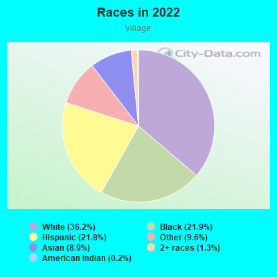
- 3,44036.2%White
- 2,08121.9%Black
- 2,07121.8%Hispanic or Latino
- 9099.6%Some other race
- 8478.9%Asian
- 1251.3%Two or more races
- 170.2%American Indian
Distribution of median household income
![Distribution of median household income]()
- 386Less than $10,000
- 562$10,000 to $19,999
- 473$20,000 to $29,999
- 428$30,000 to $39,999
- 584$40,000 to $49,999
- 870$50,000 to $59,999
- 123$60,000 to $74,999
- 567$75,000 to $99,999
- 401$100,000 to $124,999
- 315$125,000 to $149,999
- 541$150,000 to $199,999
- 774$200,000 or more

Distribution of owner-occupied house/condo value
![Distribution of owner-occupied house/condo value]()
- 1,006Less than $50,000
- 476$50,000 to $99,999
- 481$100,000 to $149,999
- 1,568$150,000 to $199,999
- 834$200,000 to $249,999
- 859$250,000 to $299,999
- 229$300,000 to $399,999
- 313$400,000 to $499,999
- 218$500,000 to $749,999
- 36$1,000,000 or more

Distribution of rent paid by renters
![Distribution of rent paid by renters]()
- 655$200 to $299
- 254$300 to $399
- 955$400 to $499
- 303$600 to $699
- 152$700 to $799
- 49$800 to $899
- 133$900 to $999
- 723$1,000 to $1,249
- 127$1,250 to $1,499
- 93$1,500 to $1,999
- 138$2,000 or more

| Males: | 4,346 |
| Females: | 3,914 |
Males:
| This neighborhood: | 36.0 years |
| Whole city: | 33.4 years |
| This neighborhood: | 43.5 years |
| Whole city: | 44.3 years |
Average household size:
| Village: | 4.4 people |
| Merchantville: | 2.6 people |
Percentage of family households:
| Village: | 50.3% |
| Merchantville: | 43.9% |
| Here: | 44.2% |
| Merchantville: | 32.7% |
Percentage of married-couple families with children (among all households):
| Village: | 21.0% |
| Merchantville: | 18.6% |
Percentage of single-mother households (among all households):
| Village: | 20.8% |
| Merchantville: | 15.4% |
Percentage of never married males 15 years old and over:
Percentage of never married females 15 years old and over:
| Village: | 23.0% |
| Merchantville: | 26.5% |
Percentage of never married females 15 years old and over:
| Village: | 15.5% |
| borough: | 18.5% |
Percentage of people that speak English not well or not at all:
| Village: | 2.8% |
| Merchantville: | 1.8% |
Percentage of people born in this state:
Percentage of people born in another U.S. state:
Percentage of native residents but born outside the U.S.:
Percentage of foreign born residents:
| Here: | 49.3% |
| Merchantville: | 52.3% |
Percentage of people born in another U.S. state:
| Village: | 37.2% |
| Merchantville: | 39.7% |
Percentage of native residents but born outside the U.S.:
| Here: | 5.1% |
| borough: | 2.7% |
Percentage of foreign born residents:
| Here: | 8.4% |
| Merchantville: | 5.3% |
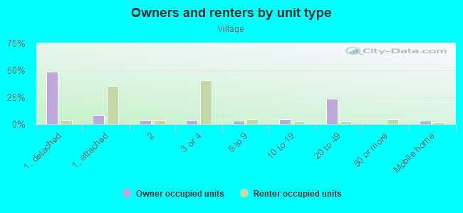
Owner-occupied
Renter-occupied

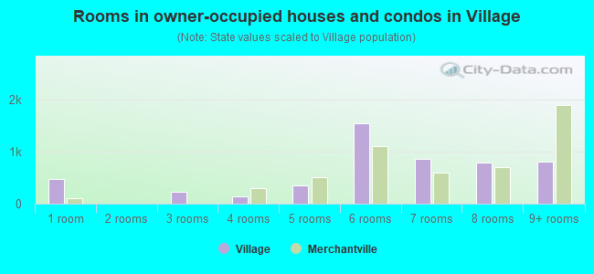
- Rooms in owner-occupied houses and condos in Village
- 4761 room
- 02 rooms
- 2243 rooms
- 1434 rooms
- 3505 rooms
- 1,5486 rooms
- 8647 rooms
- 7848 rooms
- 8139+ rooms
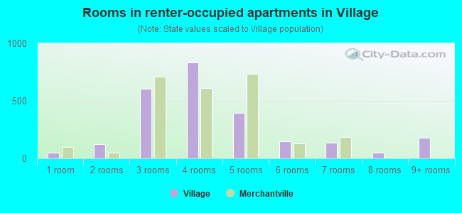
- Rooms in renter-occupied apartments in Village
- 471 room
- 1212 rooms
- 6063 rooms
- 8324 rooms
- 3965 rooms
- 1496 rooms
- 1337 rooms
- 498 rooms
- 1809+ rooms
Owner-occupied
Renter-occupied
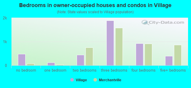
- Bedrooms in owner-occupied houses and condos in Village
- 476no bedroom
- 1251 bedroom
- 4412 bedrooms
- 1,8883 bedrooms
- 9264 bedrooms
- 3905+ bedrooms
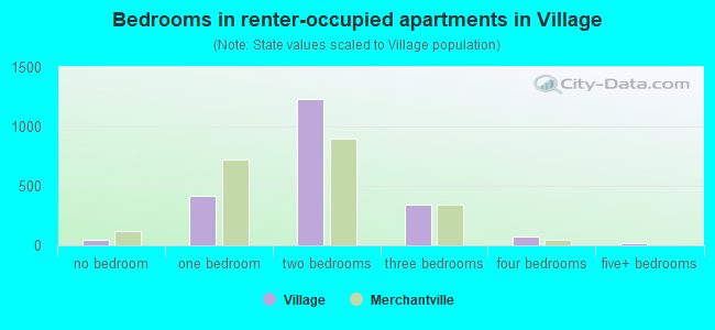
- Bedrooms in renter-occupied apartments in Village
- 47no bedroom
- 4161 bedroom
- 1,2292 bedrooms
- 3433 bedrooms
- 724 bedrooms
- 175+ bedrooms
Average number of cars or other vehicles available in houses/condos:
Average number of cars or other vehicles available in apartments:
| This neighborhood: | 2.1 |
| Merchantville: | 1.9 |
Average number of cars or other vehicles available in apartments:
| Here: | |
| borough: |
Percentage of units with a mortgage:
| Village: | 59.0% |
| Merchantville: | 77.8% |
Average estimated value of detached houses in 2022 (69.1% of all units):
| Village: | $199,329 |
| Merchantville: | $327,023 |
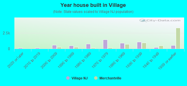
- Year house built in Village
- 1262020 or later
- 1502010 to 2019
- 5952000 to 2009
- 4871990 to 1999
- 7711980 to 1989
- 1,4481970 to 1979
- 9231960 to 1969
- 1,0941950 to 1959
- 2321940 to 1949
- 5631939 or earlier
City-data.com crime index for borough in 2020 (higher means more crime):
| City: | 106.0 |
| U.S. average: | 219.5 |
Travel time to work (commute)
![Travel time to work (commute)]()
- 32Less than 5 minutes
- 4465 to 9 minutes
- 52310 to 14 minutes
- 62115 to 19 minutes
- 75020 to 24 minutes
- 24925 to 29 minutes
- 49130 to 34 minutes
- 17735 to 39 minutes
- 5340 to 44 minutes
- 56745 to 59 minutes
- 23660 to 89 minutes
- 6590 or more minutes

Means of transportation to work
![Means of transportation to work]()
- 70.9%2,888Drove a car alone
- 16.7%680Carpooled
- 4.1%169Bus
- 7.6%310Subway or elevated rail
- 14.4%587Long-distance train or commuter rail
- 4.0%163Light rail, streetcar or trolley
- 6.0%245Taxi
- 2.1%85Bicycle
- 6.7%274Walked
- 1.7%70Other means
- 32.2%1,311Worked at home

Time leaving home to go to work
![Time leaving home to go to work]()
- 7612:00 a.m. to 4:59 a.m.
- 2095:00 a.m. to 5:29 a.m.
- 1915:30 a.m. to 5:59 a.m.
- 3066:00 a.m. to 6:29 a.m.
- 2266:30 a.m. to 6:59 a.m.
- 5597:00 a.m. to 7:29 a.m.
- 4737:30 a.m. to 7:59 a.m.
- 7958:00 a.m. to 8:29 a.m.
- 1868:30 a.m. to 8:59 a.m.
- 2829:00 a.m. to 9:59 a.m.
- 7510:00 a.m. to 10:59 a.m.
- 6511:00 a.m. to 11:59 a.m.
- 22712:00 p.m. to 3:59 p.m.
- 2964:00 p.m. to 11:59 p.m.

Occupations of males:
- Percentage of males in management occupations (except farmers):
Here: 12.6% borough: 13.1%
- Percentage of males in business and financial operations occupations:
Here: 4.2% borough: 4.5%
- Percentage of males in computer and mathematical occupations:
Here: 5.1% borough: 2.1%
- Percentage of males in architecture and engineering occupations:
Here: 1.2% borough: 2.1%
- Percentage of males in community and social services occupations:
Here: 2.1% borough: 0.1%
- Percentage of males in education, training, and library occupations:
Here: 1.7% borough: 3.1%
- Percentage of males in arts, design, entertainment, sports, and media occupations:
Here: 1.7% borough: 1.4%
- Percentage of males in healthcare practitioners and technical occupations:
Here: 5.1% borough: 1.3%
- Percentage of males in service occupations:
Here: 12.5% borough: 12.2%
- Percentage of males in sales and office occupations:
Here: 21.6% borough: 16.8%
- Percentage of males in construction, extraction, and maintenance occupations:
Here: 6.6% borough: 7.7%
- Percentage of males in production occupations:
Here: 11.9% borough: 6.6%
- Percentage of males in transportation occupations:
Here: 4.3% borough: 14.9%
- Percentage of males in material moving occupations:
Here: 4.4% borough: 9.8%
Occupations of females:
- Percentage of females in management occupations (except farmers):
Here: 9.1% borough: 9.7%
- Percentage of females in business and financial operations occupations:
Here: 3.0% borough: 6.0%
- Percentage of females in computer and mathematical occupations:
Here: 1.2% borough: 2.1%
- Percentage of females in life, physical, and social science occupations:
Here: 2.1% borough: 2.3%
- Percentage of females in education, training, and library occupations:
Here: 17.3% borough: 11.0%
- Percentage of females in arts, design, entertainment, sports, and media occupations:
Here: 1.9% borough: 1.4%
- Percentage of females in healthcare practitioners and technical occupations:
Here: 15.4% borough: 9.6%
- Percentage of females in service occupations:
Here: 12.2% borough: 15.1%
- Percentage of females in sales and office occupations:
Here: 34.7% borough: 21.0%
- Percentage of females in transportation occupations:
Here: 1.0% borough: 4.7%
Percentage of people 16-64 in Armed Forces:
| Village: | 0.0% |
| Merchantville: | 0.0% |
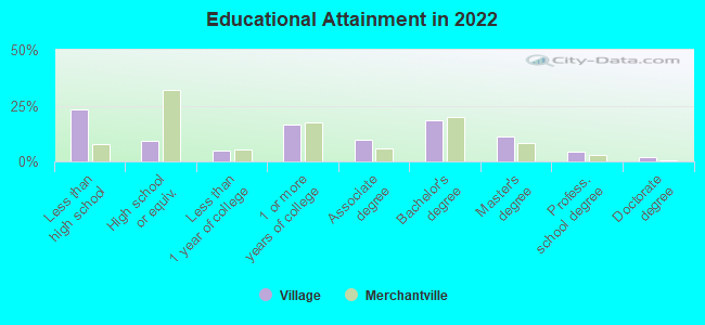
Education in this neighborhood (subdivision or community):
- Percentage of people 3 years and older in K-12 schools:
Village: 31.1% Merchantville: 20.5%
- Percentage of people 3 years and older in undergraduate colleges:
Village: 11.7% Merchantville: 2.6%
- Percentage of people 3 years and older in grad. or professional schools:
Village: 1.8% Merchantville: 1.0%
- Percentage of students K-12 enrolled in private schools:
Village: 56.2% Merchantville: 10.1%
Percentage of population below poverty level:
| Village: | 12.6% |
| Merchantville: | 16.0% |
Percentage of married-couple families with both working:
| Village: | 114.6% |
| Merchantville: | 83.2% |
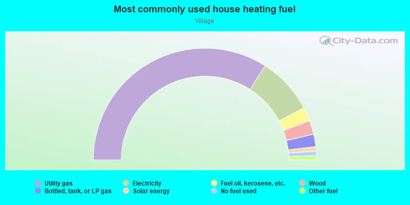
- 68.1%Utility gas
- 16.5%Electricity
- 4.0%Fuel oil, kerosene, etc.
- 4.0%Wood
- 3.6%Bottled, tank, or LP gas
- 1.3%Solar energy
- 1.3%No fuel used
- 1.2%Other fuel
Other features:
Pennsauken Creek South Br (Pennsauken Crk S Br)
Length: 0.12 miles
Directions: E-W, N-S, SE-NW, SW-NE
Directions: E-W, N-S, SE-NW, SW-NE
Highways in this neighborhood:
N Crescent Blvd (US Hwy 130)
Length: 4.64 miles
Directions: E-W, SW-NE
Address range: 7101 to 9499
Directions: E-W, SW-NE
Address range: 7101 to 9499
State Rte 90
Length: 3.36 miles
Directions: E-W, SW-NE
Directions: E-W, SW-NE
Palmyra Bridge Rd (Palmyra Bridge Blvd, State Rte 73)
Length: 0.86 miles
Direction: SE-NW
Address range: 2100 to 2198
Direction: SE-NW
Address range: 2100 to 2198
Roads and streets:
Haddonfield Rd
Length: 2.63 miles
Directions: E-W, N-S, SE-NW, SW-NE
Address range: 2100 to 4499
Directions: E-W, N-S, SE-NW, SW-NE
Address range: 2100 to 4499
Wyndam Rd
Length: 1.58 miles
Directions: E-W, SE-NW, SW-NE
Address range: 7200 to 8999
Directions: E-W, SE-NW, SW-NE
Address range: 7200 to 8999
Union Ave
Length: 1.51 miles
Directions: N-S, SE-NW
Address range: 2200 to 4399
Directions: N-S, SE-NW
Address range: 2200 to 4399
Park Ave
Length: 1.41 miles
Direction: SW-NE
Address range: 7100 to 8799
Direction: SW-NE
Address range: 7100 to 8799
Corbett Rd
Length: 1.38 miles
Directions: E-W, N-S, SE-NW, SW-NE
Address range: 2200 to 8399
Directions: E-W, N-S, SE-NW, SW-NE
Address range: 2200 to 8399
Collins Ave
Length: 1.12 miles
Directions: E-W, SW-NE
Address range: 7200 to 9399
Directions: E-W, SW-NE
Address range: 7200 to 9399
Grant Ave
Length: 1.10 miles
Directions: E-W, SW-NE
Address range: 7200 to 8199
Directions: E-W, SW-NE
Address range: 7200 to 8199
Rudderow Ave
Length: 1.08 miles
Direction: E-W
Address range: 7100 to 8799
Direction: E-W
Address range: 7100 to 8799
Gladwyn Ave
Length: 1.07 miles
Directions: N-S, SE-NW
Address range: 2500 to 4399
Directions: N-S, SE-NW
Address range: 2500 to 4399
Finlaw Ave
Length: 1.06 miles
Directions: N-S, SE-NW, SW-NE
Address range: 2200 to 4399
Directions: N-S, SE-NW, SW-NE
Address range: 2200 to 4399
Cooper Ave
Length: 1.01 miles
Directions: E-W, N-S, SE-NW, SW-NE
Address range: 2600 to 4398
Directions: E-W, N-S, SE-NW, SW-NE
Address range: 2600 to 4398
Maple Ave
Length: 0.88 miles
Direction: E-W
Address range: 1000 to 8799
Direction: E-W
Address range: 1000 to 8799
New Jersey Ave
Length: 0.76 miles
Directions: E-W, N-S, SE-NW, SW-NE
Address range: 3401 to 4499
Directions: E-W, N-S, SE-NW, SW-NE
Address range: 3401 to 4499
Marion Ave
Length: 0.75 miles
Directions: E-W, SW-NE
Address range: 7100 to 8299
Directions: E-W, SW-NE
Address range: 7100 to 8299
Orchard Ave
Length: 0.73 miles
Directions: E-W, SW-NE
Address range: 7300 to 8799
Directions: E-W, SW-NE
Address range: 7300 to 8799
Herbert Ave
Length: 0.72 miles
Directions: E-W, N-S, SE-NW, SW-NE
Address range: 3700 to 8799
Directions: E-W, N-S, SE-NW, SW-NE
Address range: 3700 to 8799
Stockton Ave
Length: 0.70 miles
Directions: E-W, SW-NE
Address range: 7700 to 8799
Directions: E-W, SW-NE
Address range: 7700 to 8799
Rogers Ave
Length: 0.69 miles
Directions: E-W, SW-NE
Address range: 7100 to 8899
Directions: E-W, SW-NE
Address range: 7100 to 8899
Irving Ave
Length: 0.68 miles
Directions: E-W, SW-NE
Address range: 7200 to 9199
Directions: E-W, SW-NE
Address range: 7200 to 9199
Githens Ave
Length: 0.63 miles
Directions: E-W, SW-NE
Address range: 7100 to 8662
Directions: E-W, SW-NE
Address range: 7100 to 8662
Collins Ln
Length: 0.62 miles
Directions: E-W, SE-NW, SW-NE
Address range: 7000 to 7799
Directions: E-W, SE-NW, SW-NE
Address range: 7000 to 7799
Pennsauken Hwy
Length: 0.56 miles
Directions: E-W, SE-NW, SW-NE
Address range: 9000 to 9199
Directions: E-W, SE-NW, SW-NE
Address range: 9000 to 9199
Powell Ave
Length: 0.56 miles
Direction: N-S
Address range: 2500 to 3099
Direction: N-S
Address range: 2500 to 3099
Bryn Mawr Ave
Length: 0.53 miles
Directions: E-W, N-S, SW-NE
Address range: 8200 to 8799
Directions: E-W, N-S, SW-NE
Address range: 8200 to 8799
Osler Ave
Length: 0.51 miles
Directions: E-W, SW-NE
Address range: 8200 to 8799
Directions: E-W, SW-NE
Address range: 8200 to 8799
Westfield Ave
Length: 0.50 miles
Directions: E-W, SW-NE
Address range: 7100 to 7499
Directions: E-W, SW-NE
Address range: 7100 to 7499
Harvey Ave
Length: 0.48 miles
Directions: E-W, SW-NE
Address range: 7400 to 9199
Directions: E-W, SW-NE
Address range: 7400 to 9199
Walnut Ave
Length: 0.47 miles
Direction: SW-NE
Address range: 7100 to 7499
Direction: SW-NE
Address range: 7100 to 7499
New York Ave
Length: 0.45 miles
Directions: E-W, N-S, SE-NW, SW-NE
Address range: 3600 to 4499
Directions: E-W, N-S, SE-NW, SW-NE
Address range: 3600 to 4499
Cedar Ave
Length: 0.43 miles
Directions: E-W, SW-NE
Address range: 7000 to 7499
Directions: E-W, SW-NE
Address range: 7000 to 7499
Commerce Hwy
Length: 0.41 miles
Directions: N-S, SE-NW, SW-NE
Address range: 9200 to 9299
Directions: N-S, SE-NW, SW-NE
Address range: 9200 to 9299
Howard Ave
Length: 0.37 miles
Directions: E-W, SE-NW, SW-NE
Address range: 3200 to 3499
Directions: E-W, SE-NW, SW-NE
Address range: 3200 to 3499
Greenbrier Rd
Length: 0.36 miles
Directions: E-W, SE-NW, SW-NE
Address range: 7700 to 7911
Directions: E-W, SE-NW, SW-NE
Address range: 7700 to 7911
Delaware Ave
Length: 0.35 miles
Directions: N-S, SE-NW
Address range: 3600 to 4499
Directions: N-S, SE-NW
Address range: 3600 to 4499
Wolf Ave
Length: 0.31 miles
Directions: N-S, SE-NW
Address range: 2600 to 2999
Directions: N-S, SE-NW
Address range: 2600 to 2999
Baxter Ave
Length: 0.31 miles
Directions: E-W, SW-NE
Address range: 7400 to 7599
Directions: E-W, SW-NE
Address range: 7400 to 7599
Morton St (Morton Ave)
Length: 0.30 miles
Directions: N-S, SW-NE
Address range: 2700 to 2998
Directions: N-S, SW-NE
Address range: 2700 to 2998
Harrowgate Dr
Length: 0.29 miles
Directions: E-W, N-S, SE-NW, SW-NE
Address range: 8301 to 8399
Directions: E-W, N-S, SE-NW, SW-NE
Address range: 8301 to 8399
Crofton Ln
Length: 0.27 miles
Directions: E-W, N-S, SW-NE
Address range: 8300 to 8499
Directions: E-W, N-S, SW-NE
Address range: 8300 to 8499
Elm Ave
Length: 0.27 miles
Directions: N-S, SE-NW
Address range: 3401 to 4399
Directions: N-S, SE-NW
Address range: 3401 to 4399
Broad St
Length: 0.27 miles
Directions: E-W, N-S, SW-NE
Address range: 7509 to 7899
Directions: E-W, N-S, SW-NE
Address range: 7509 to 7899
Msgr Fallon Dr
Length: 0.27 miles
Directions: E-W, N-S, SE-NW, SW-NE
Address range: 7500 to 7599
Directions: E-W, N-S, SE-NW, SW-NE
Address range: 7500 to 7599
Prince Ave
Length: 0.26 miles
Directions: E-W, SE-NW
Directions: E-W, SE-NW
Wessex Dr
Length: 0.26 miles
Directions: E-W, N-S, SE-NW, SW-NE
Address range: 8300 to 8499
Directions: E-W, N-S, SE-NW, SW-NE
Address range: 8300 to 8499
Burning Tree Rd
Length: 0.25 miles
Directions: E-W, N-S, SW-NE
Address range: 2500 to 2699
Directions: E-W, N-S, SW-NE
Address range: 2500 to 2699
Palace Ct
Length: 0.24 miles
Directions: E-W, N-S, SE-NW, SW-NE
Address range: 3400 to 3499
Directions: E-W, N-S, SE-NW, SW-NE
Address range: 3400 to 3499
Maryland Ave
Length: 0.24 miles
Directions: N-S, SE-NW
Address range: 3600 to 4499
Directions: N-S, SE-NW
Address range: 3600 to 4499
Hesson Ln
Length: 0.23 miles
Directions: E-W, SE-NW, SW-NE
Address range: 7700 to 7799
Directions: E-W, SE-NW, SW-NE
Address range: 7700 to 7799
Burrough Dover Ln
Length: 0.22 miles
Direction: E-W
Address range: 9000 to 9299
Direction: E-W
Address range: 9000 to 9299
Weymouth Dr
Length: 0.22 miles
Directions: E-W, SE-NW, SW-NE
Address range: 8200 to 8299
Directions: E-W, SE-NW, SW-NE
Address range: 8200 to 8299
Buckingham Ln
Length: 0.21 miles
Directions: N-S, SE-NW, SW-NE
Address range: 3400 to 3499
Directions: N-S, SE-NW, SW-NE
Address range: 3400 to 3499
New Hampshire Ln
Length: 0.21 miles
Directions: E-W, SW-NE
Address range: 7800 to 7899
Directions: E-W, SW-NE
Address range: 7800 to 7899
Pennsylvania Ave
Length: 0.20 miles
Direction: SE-NW
Address range: 3400 to 3599
Direction: SE-NW
Address range: 3400 to 3599
Pettit Ln
Length: 0.20 miles
Directions: E-W, N-S, SE-NW, SW-NE
Address range: 2700 to 2799
Directions: E-W, N-S, SE-NW, SW-NE
Address range: 2700 to 2799
Pettit Rd
Length: 0.19 miles
Direction: N-S
Address range: 2500 to 2699
Direction: N-S
Address range: 2500 to 2699
Fork Landing Rd
Length: 0.19 miles
Direction: SW-NE
Address range: 8800 to 8897
Direction: SW-NE
Address range: 8800 to 8897
Hadley Dr
Length: 0.19 miles
Direction: N-S
Address range: 2500 to 2699
Direction: N-S
Address range: 2500 to 2699
Colonial Ave
Length: 0.18 miles
Directions: E-W, N-S, SW-NE
Address range: 2700 to 2899
Directions: E-W, N-S, SW-NE
Address range: 2700 to 2899
Tauton Dr
Length: 0.18 miles
Directions: N-S, SE-NW
Address range: 2500 to 2699
Directions: N-S, SE-NW
Address range: 2500 to 2699
Starr Rd
Length: 0.18 miles
Direction: N-S
Address range: 2632 to 2699
Direction: N-S
Address range: 2632 to 2699
Oakley Dr
Length: 0.17 miles
Directions: N-S, SE-NW
Address range: 2500 to 2699
Directions: N-S, SE-NW
Address range: 2500 to 2699
Rogers Blvd
Length: 0.17 miles
Direction: SW-NE
Direction: SW-NE
New Jersey Ct
Length: 0.16 miles
Directions: E-W, N-S, SE-NW, SW-NE
Address range: 3434 to 3499
Directions: E-W, N-S, SE-NW, SW-NE
Address range: 3434 to 3499
Doral Dr
Length: 0.16 miles
Directions: E-W, N-S, SE-NW, SW-NE
Address range: 2500 to 2599
Directions: E-W, N-S, SE-NW, SW-NE
Address range: 2500 to 2599
Florence Ave
Length: 0.15 miles
Directions: N-S, SE-NW, SW-NE
Directions: N-S, SE-NW, SW-NE
Manor Ave
Length: 0.15 miles
Directions: E-W, N-S
Address range: 4300 to 4399
Directions: E-W, N-S
Address range: 4300 to 4399
Smiley Ave
Length: 0.15 miles
Direction: E-W
Address range: 8200 to 8399
Direction: E-W
Address range: 8200 to 8399
Freeman Ave
Length: 0.15 miles
Directions: N-S, SE-NW, SW-NE
Directions: N-S, SE-NW, SW-NE
St Martins Rd
Length: 0.15 miles
Directions: E-W, N-S, SE-NW
Address range: 3400 to 3499
Directions: E-W, N-S, SE-NW
Address range: 3400 to 3499
Fairway Blvd
Length: 0.15 miles
Direction: E-W
Direction: E-W
Foehl Ave
Length: 0.15 miles
Direction: SE-NW
Address range: 2600 to 2699
Direction: SE-NW
Address range: 2600 to 2699
Davies Ave
Length: 0.15 miles
Direction: SE-NW
Address range: 2600 to 2699
Direction: SE-NW
Address range: 2600 to 2699
Manall Ave
Length: 0.15 miles
Direction: SE-NW
Address range: 2600 to 2699
Direction: SE-NW
Address range: 2600 to 2699
Rockafellow Ave
Length: 0.14 miles
Direction: SE-NW
Address range: 2600 to 2699
Direction: SE-NW
Address range: 2600 to 2699
Patterson Ln
Length: 0.14 miles
Direction: E-W
Address range: 7700 to 7799
Direction: E-W
Address range: 7700 to 7799
Piersanti Dr
Length: 0.13 miles
Direction: E-W
Address range: 7600 to 7699
Direction: E-W
Address range: 7600 to 7699
Shelley Ln
Length: 0.13 miles
Direction: SE-NW
Address range: 2400 to 2499
Direction: SE-NW
Address range: 2400 to 2499
Githens Ave (School Ln)
Length: 0.12 miles
Direction: E-W
Address range: 7620 to 7799
Direction: E-W
Address range: 7620 to 7799
York Rd
Length: 0.12 miles
Direction: SE-NW
Address range: 2400 to 2499
Direction: SE-NW
Address range: 2400 to 2499
Par Ct
Length: 0.11 miles
Direction: SE-NW
Address range: 17 to 67
Direction: SE-NW
Address range: 17 to 67
Dickens Dr
Length: 0.11 miles
Directions: N-S, SE-NW
Address range: 2400 to 2499
Directions: N-S, SE-NW
Address range: 2400 to 2499
Miller Ct
Length: 0.10 miles
Directions: E-W, SE-NW
Address range: 7600 to 7799
Directions: E-W, SE-NW
Address range: 7600 to 7799
Jackson Ave
Length: 0.10 miles
Directions: E-W, SW-NE
Address range: 7400 to 7499
Directions: E-W, SW-NE
Address range: 7400 to 7499
Connecticut Ave
Length: 0.10 miles
Direction: SE-NW
Address range: 3600 to 3699
Direction: SE-NW
Address range: 3600 to 3699
Howard St
Length: 0.10 miles
Direction: N-S
Address range: 700 to 799
Direction: N-S
Address range: 700 to 799
Schoolhouse Ln
Length: 0.10 miles
Directions: E-W, N-S, SE-NW, SW-NE
Address range: 8400 to 8499
Directions: E-W, N-S, SE-NW, SW-NE
Address range: 8400 to 8499
Barclay Ave
Length: 0.10 miles
Direction: SE-NW
Direction: SE-NW
Bailey Ave
Length: 0.10 miles
Directions: E-W, SW-NE
Address range: 9000 to 9099
Directions: E-W, SW-NE
Address range: 9000 to 9099
Industrial Hwy (John Tipton Blvd)
Length: 0.08 miles
Direction: SE-NW
Direction: SE-NW
Volney Ave
Length: 0.07 miles
Direction: N-S
Address range: 4300 to 4399
Direction: N-S
Address range: 4300 to 4399
Avignon Way
Length: 0.07 miles
Directions: E-W, N-S, SE-NW
Address range: 100 to 199
Directions: E-W, N-S, SE-NW
Address range: 100 to 199
Willis Ave
Length: 0.07 miles
Direction: N-S
Address range: 4300 to 4399
Direction: N-S
Address range: 4300 to 4399
Burling Ave
Length: 0.07 miles
Direction: N-S
Address range: 4300 to 4399
Direction: N-S
Address range: 4300 to 4399
Piersanti Ct
Length: 0.06 miles
Direction: E-W
Address range: 7700 to 7799
Direction: E-W
Address range: 7700 to 7799
Rhode Island Ct
Length: 0.06 miles
Direction: SE-NW
Address range: 3700 to 3799
Direction: SE-NW
Address range: 3700 to 3799
Wessex Rd
Length: 0.05 miles
Direction: N-S
Direction: N-S
Silver Ave
Length: 0.05 miles
Direction: SE-NW
Address range: 3500 to 3599
Direction: SE-NW
Address range: 3500 to 3599
Iron Rock Ct
Length: 0.05 miles
Directions: N-S, SE-NW
Address range: 3400 to 3499
Directions: N-S, SE-NW
Address range: 3400 to 3499
Delaware Ct
Length: 0.05 miles
Direction: SE-NW
Address range: 3400 to 3599
Direction: SE-NW
Address range: 3400 to 3599
Connecticut Ct
Length: 0.05 miles
Direction: SE-NW
Address range: 3700 to 3799
Direction: SE-NW
Address range: 3700 to 3799
Oakley Pl
Length: 0.05 miles
Direction: N-S
Address range: 2500 to 2599
Direction: N-S
Address range: 2500 to 2599
Tarrington Ct
Length: 0.04 miles
Direction: SE-NW
Address range: 8000 to 8099
Direction: SE-NW
Address range: 8000 to 8099
Burning Tree Ct
Length: 0.04 miles
Direction: E-W
Address range: 2501 to 2599
Direction: E-W
Address range: 2501 to 2599
Pettit Ct
Length: 0.04 miles
Direction: N-S
Address range: 2400 to 2599
Direction: N-S
Address range: 2400 to 2599
Fenwick Ct
Length: 0.04 miles
Direction: SE-NW
Address range: 8000 to 8099
Direction: SE-NW
Address range: 8000 to 8099
Greensway Walk
Length: 0.04 miles
Direction: SE-NW
Address range: 1 to 99
Direction: SE-NW
Address range: 1 to 99
Kent Ct
Length: 0.03 miles
Directions: N-S, SE-NW
Address range: 2700 to 2799
Directions: N-S, SE-NW
Address range: 2700 to 2799
Horseshoe Ct
Length: 0.03 miles
Direction: SE-NW
Address range: 8101 to 8199
Direction: SE-NW
Address range: 8101 to 8199
Wessex Ct
Length: 0.03 miles
Direction: SE-NW
Address range: 8345 to 8349
Direction: SE-NW
Address range: 8345 to 8349
Greenbriar Rd (Greenbrier Rd)
Length: 0.02 miles
Direction: SW-NE
Address range: 7700 to 7709
Direction: SW-NE
Address range: 7700 to 7709
Railroad features:
Penn Central RR
Length: 3.15 miles
Directions: E-W, N-S, SE-NW
Directions: E-W, N-S, SE-NW
Other features:
South Branch Pennsauken Crk
Length: 2.41 miles
Directions: E-W, N-S, SE-NW, SW-NE
Directions: E-W, N-S, SE-NW, SW-NE
Puchack Run
Length: 1.46 miles
Directions: E-W, N-S, SE-NW, SW-NE
Directions: E-W, N-S, SE-NW, SW-NE
Pennsauken Crk S Br (Pennsauken Creek South Br)
Length: 0.12 miles
Directions: E-W, N-S, SE-NW, SW-NE
Directions: E-W, N-S, SE-NW, SW-NE