Sherwood Forest neighborhood in Rome, Georgia (GA), 30161 detailed profile
Settings
X


Business Search - 14 Million verified businesses
Area: 5.234 square miles
Population: 2,428
Population density:
| Sherwood Forest: | 464 people per square mile |
| Rome: | 1,280 people per square mile |

- 1,56940.2%White
- 1,34034.3%Some other race
- 68317.5%Black
- 1353.5%Asian
- 1102.8%Hispanic or Latino
- 461.2%Native Hawaiian and Other
Pacific Islander - 210.5%Two or more races

Median household income in 2022:
| Sherwood Forest: | $70,728 |
| Rome: | $48,512 |
Distribution of median household income
![Distribution of median household income]()
- 71Less than $10,000
- 104$10,000 to $19,999
- 86$20,000 to $29,999
- 193$30,000 to $39,999
- 90$40,000 to $49,999
- 129$50,000 to $59,999
- 90$60,000 to $74,999
- 146$75,000 to $99,999
- 109$100,000 to $124,999
- 58$125,000 to $149,999
- 84$150,000 to $199,999
- 193$200,000 or more

Distribution of owner-occupied house/condo value
![Distribution of owner-occupied house/condo value]()
- 547Less than $50,000
- 550$50,000 to $99,999
- 184$100,000 to $149,999
- 300$150,000 to $199,999
- 40$200,000 to $249,999
- 64$250,000 to $299,999
- 149$300,000 to $399,999
- 77$400,000 to $499,999
- 43$500,000 to $749,999
- 25$750,000 to $999,999
- 26$1,000,000 or more

Distribution of rent paid by renters
![Distribution of rent paid by renters]()
- 187Less than $100
- 360$100 to $199
- 256$200 to $299
- 270$300 to $399
- 752$400 to $499
- 236$500 to $599
- 288$600 to $699
- 350$700 to $799
- 24$800 to $899
- 57$900 to $999
- 129$1,000 to $1,249
- 188$1,250 to $1,499
- 287$1,500 to $1,999
- 70$2,000 or more

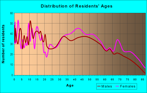
| Males: | 1,065 |
| Females: | 1,363 |
Males:
| This neighborhood: | 39.8 years |
| Whole city: | 36.1 years |
| This neighborhood: | 40.5 years |
| Whole city: | 37.9 years |
Average household size:
| Sherwood Forest: | 5.6 people |
| Rome: | 2.5 people |
Percentage of family households:
| Sherwood Forest: | 44.6% |
| Rome: | 45.4% |
| Here: | 39.5% |
| Rome: | 36.6% |
Percentage of married-couple families with children (among all households):
| Sherwood Forest: | 19.5% |
| Rome: | 22.4% |
Percentage of single-mother households (among all households):
| Sherwood Forest: | 32.2% |
| Rome: | 15.0% |
Percentage of never married males 15 years old and over:
Percentage of never married females 15 years old and over:
| Sherwood Forest: | 18.1% |
| Rome: | 19.0% |
Percentage of never married females 15 years old and over:
| Sherwood Forest: | 17.4% |
| city: | 20.3% |
Percentage of people that speak English not well or not at all:
| Sherwood Forest: | 0.6% |
| Rome: | 5.6% |
Percentage of people born in this state:
Percentage of people born in another U.S. state:
Percentage of native residents but born outside the U.S.:
Percentage of foreign born residents:
| Here: | 71.0% |
| Rome: | 66.1% |
Percentage of people born in another U.S. state:
| Sherwood Forest: | 26.4% |
| Rome: | 20.8% |
Percentage of native residents but born outside the U.S.:
| Here: | 0.1% |
| city: | 0.6% |
Percentage of foreign born residents:
| Here: | 2.4% |
| Rome: | 12.4% |

Owner-occupied
Renter-occupied


- Rooms in owner-occupied houses and condos in Sherwood Forest
- 01 room
- 192 rooms
- 863 rooms
- 844 rooms
- 625 rooms
- 2756 rooms
- 2297 rooms
- 838 rooms
- 1119+ rooms

- Rooms in renter-occupied apartments in Sherwood Forest
- 1911 room
- 4082 rooms
- 2353 rooms
- 5534 rooms
- 455 rooms
- 276 rooms
- 747 rooms
- 3528 rooms
- 109+ rooms
Owner-occupied
Renter-occupied

- Bedrooms in owner-occupied houses and condos in Sherwood Forest
- 0no bedroom
- 321 bedroom
- 1212 bedrooms
- 4423 bedrooms
- 1584 bedrooms
- 1115+ bedrooms

- Bedrooms in renter-occupied apartments in Sherwood Forest
- 191no bedroom
- 4631 bedroom
- 4932 bedrooms
- 1113 bedrooms
- 284 bedrooms
- 05+ bedrooms
Average number of cars or other vehicles available in houses/condos:
Average number of cars or other vehicles available in apartments:
| This neighborhood: | 1.0 |
| Rome: | 2.1 |
Average number of cars or other vehicles available in apartments:
| Here: | 6.6 |
| city: | 1.0 |
Percentage of units with a mortgage:
| Sherwood Forest: | 55.1% |
| Rome: | 54.9% |
Average estimated value of detached houses in 2022 (78.5% of all units):
| Sherwood Forest: | $153,978 |
| Georgia: | $376,364 |

- Year house built in Sherwood Forest
- 222020 or later
- 1342010 to 2019
- 1762000 to 2009
- 1071990 to 1999
- 491980 to 1989
- 1381970 to 1979
- 1171960 to 1969
- 2841950 to 1959
- 741940 to 1949
- 901939 or earlier

City-data.com crime index for city in 2020 (higher means more crime):
| City: | 213.7 |
| U.S. average: | 219.5 |
Travel time to work (commute)
![Travel time to work (commute)]()
- 40Less than 5 minutes
- 845 to 9 minutes
- 43610 to 14 minutes
- 38515 to 19 minutes
- 10920 to 24 minutes
- 6325 to 29 minutes
- 23430 to 34 minutes
- 1535 to 39 minutes
- 2940 to 44 minutes
- 10945 to 59 minutes
- 4360 to 89 minutes
- 13390 or more minutes

Means of transportation to work
![Means of transportation to work]()
- 84.3%745Drove a car alone
- 4.1%36Carpooled
- 3.3%29Bus
- 0.3%3Ferryboat
- 1.2%11Taxi
- 0.6%5Walked
- 1.8%16Other means
- 12.3%109Worked at home

Time leaving home to go to work
![Time leaving home to go to work]()
- 8312:00 a.m. to 4:59 a.m.
- 415:00 a.m. to 5:29 a.m.
- 1065:30 a.m. to 5:59 a.m.
- 356:00 a.m. to 6:29 a.m.
- 1776:30 a.m. to 6:59 a.m.
- 2517:00 a.m. to 7:29 a.m.
- 2147:30 a.m. to 7:59 a.m.
- 1128:00 a.m. to 8:29 a.m.
- 1308:30 a.m. to 8:59 a.m.
- 1539:00 a.m. to 9:59 a.m.
- 3410:00 a.m. to 10:59 a.m.
- 1111:00 a.m. to 11:59 a.m.
- 11912:00 p.m. to 3:59 p.m.
- 864:00 p.m. to 11:59 p.m.

Occupations of males:
- Percentage of males in management occupations (except farmers):
Here: 15.1% city: 10.2%
- Percentage of males in business and financial operations occupations:
Here: 4.0% city: 2.8%
- Percentage of males in computer and mathematical occupations:
Here: 3.3% city: 1.8%
- Percentage of males in architecture and engineering occupations:
Here: 1.8% city: 1.8%
- Percentage of males in community and social services occupations:
Here: 10.1% city: 1.7%
- Percentage of males in legal occupations:
Here: 2.7% city: 1.0%
- Percentage of males in education, training, and library occupations:
Here: 4.3% city: 4.0%
- Percentage of males in healthcare practitioners and technical occupations:
Here: 1.6% city: 4.1%
- Percentage of males in service occupations:
Here: 7.8% city: 18.0%
- Percentage of males in sales and office occupations:
Here: 7.4% city: 11.4%
- Percentage of males in production occupations:
Here: 8.6% city: 15.0%
- Percentage of males in transportation occupations:
Here: 13.1% city: 3.2%
- Percentage of males in material moving occupations:
Here: 16.7% city: 5.6%
Occupations of females:
- Percentage of females in management occupations (except farmers):
Here: 7.4% city: 3.3%
- Percentage of females in computer and mathematical occupations:
Here: 1.6% city: 0.7%
- Percentage of females in life, physical, and social science occupations:
Here: 1.4% city: 0.5%
- Percentage of females in community and social services occupations:
Here: 3.8% city: 3.5%
- Percentage of females in legal occupations:
Here: 8.4% city: 1.1%
- Percentage of females in education, training, and library occupations:
Here: 21.5% city: 9.2%
- Percentage of females in arts, design, entertainment, sports, and media occupations:
Here: 7.6% city: 1.7%
- Percentage of females in healthcare practitioners and technical occupations:
Here: 6.7% city: 10.6%
- Percentage of females in service occupations:
Here: 15.5% city: 26.4%
- Percentage of females in sales and office occupations:
Here: 15.3% city: 23.6%
- Percentage of females in construction, extraction, and maintenance occupations:
Here: 2.2% city: 0.4%
- Percentage of females in production occupations:
Here: 16.1% city: 9.7%
Education in this neighborhood (subdivision or community):
- Percentage of people 3 years and older in K-12 schools:
Sherwood Forest: 26.2% Rome: 18.8%
- Percentage of people 3 years and older in undergraduate colleges:
Sherwood Forest: 7.1% Rome: 4.7%
- Percentage of people 3 years and older in grad. or professional schools:
Sherwood Forest: 5.1% Rome: 1.0%
- Percentage of students K-12 enrolled in private schools:
Sherwood Forest: 108.3% Rome: 14.1%
Percentage of population below poverty level:
| Sherwood Forest: | 12.5% |
| Rome: | 22.2% |
Percentage of married-couple families with both working:
| Sherwood Forest: | 112.6% |
| Rome: | 68.1% |

- 48.3%Electricity
- 35.6%Utility gas
- 5.4%No fuel used
- 5.2%Bottled, tank, or LP gas
- 2.4%Other fuel
- 1.8%Wood
- 1.3%Solar energy
Highways in this neighborhood:
State Loop 1 (E Rome Byp)
Length: 6.86 miles
Directions: N-S, SE-NW
Directions: N-S, SE-NW
State Rte 53 (Martin Luther King Jr Blvd)
Length: 3.49 miles
Directions: E-W, SW-NE
Address range: 900 to 1899
Directions: E-W, SW-NE
Address range: 900 to 1899
State Rte 293 (Kingston Hwy NE)
Length: 0.80 miles
Directions: E-W, SE-NW
Address range: 1409 to 1699
Directions: E-W, SE-NW
Address range: 1409 to 1699
State Rte 1 (State Rte 20, US Hwy 27, Turner McCall Blvd)
Length: 0.18 miles
Direction: N-S
Direction: N-S
Roads and streets:
Turner Chapel Rd SE
Length: 2.59 miles
Directions: E-W, N-S, SE-NW, SW-NE
Address range: 1 to 1103
Directions: E-W, N-S, SE-NW, SW-NE
Address range: 1 to 1103
Robin Hood Rd
Length: 1.49 miles
Directions: E-W, N-S, SE-NW, SW-NE
Address range: 1 to 499
Directions: E-W, N-S, SE-NW, SW-NE
Address range: 1 to 499
Calhoun Ave
Length: 1.45 miles
Directions: E-W, SW-NE
Address range: 4 to 1549
Directions: E-W, SW-NE
Address range: 4 to 1549
Wilshire Rd NE
Length: 1.31 miles
Directions: E-W, N-S, SE-NW, SW-NE
Address range: 1 to 599
Directions: E-W, N-S, SE-NW, SW-NE
Address range: 1 to 599
Kingston Ave NE
Length: 1.12 miles
Directions: E-W, SE-NW
Address range: 4 to 1099
Directions: E-W, SE-NW
Address range: 4 to 1099
Valley Brook Dr
Length: 0.95 miles
Direction: E-W
Address range: 1 to 299
Direction: E-W
Address range: 1 to 299
Kingston Rd NE
Length: 0.94 miles
Directions: E-W, SE-NW
Address range: 1006 to 2357
Directions: E-W, SE-NW
Address range: 1006 to 2357
Surrey Trl
Length: 0.83 miles
Directions: E-W, N-S, SE-NW, SW-NE
Address range: 1 to 99
Directions: E-W, N-S, SE-NW, SW-NE
Address range: 1 to 99
Sequoia Dr SE
Length: 0.75 miles
Directions: E-W, N-S, SE-NW, SW-NE
Address range: 100 to 199
Directions: E-W, N-S, SE-NW, SW-NE
Address range: 100 to 199
Church St
Length: 0.72 miles
Directions: N-S, SE-NW
Address range: 1 to 499
Directions: N-S, SE-NW
Address range: 1 to 499
Spider Webb Dr
Length: 0.72 miles
Directions: E-W, SE-NW, SW-NE
Address range: 800 to 1299
Directions: E-W, SE-NW, SW-NE
Address range: 800 to 1299
Calhoun Hwy NE (Calhoun Rd NE)
Length: 0.71 miles
Directions: E-W, SW-NE
Address range: 1528 to 1847
Directions: E-W, SW-NE
Address range: 1528 to 1847
Wade St NE
Length: 0.65 miles
Directions: E-W, N-S, SE-NW, SW-NE
Address range: 1 to 293
Directions: E-W, N-S, SE-NW, SW-NE
Address range: 1 to 293
View Dr SE
Length: 0.64 miles
Directions: E-W, N-S, SE-NW, SW-NE
Address range: 1 to 99
Directions: E-W, N-S, SE-NW, SW-NE
Address range: 1 to 99
Lakeshore Dr
Length: 0.62 miles
Directions: E-W, N-S, SE-NW, SW-NE
Address range: 1 to 235
Directions: E-W, N-S, SE-NW, SW-NE
Address range: 1 to 235
Atteiram Dr
Length: 0.60 miles
Directions: E-W, N-S, SE-NW, SW-NE
Address range: 1 to 199
Directions: E-W, N-S, SE-NW, SW-NE
Address range: 1 to 199
Gordon St
Length: 0.59 miles
Direction: E-W
Address range: 1300 to 1899
Direction: E-W
Address range: 1300 to 1899
Mitchell Cir
Length: 0.58 miles
Directions: E-W, N-S, SE-NW, SW-NE
Address range: 1 to 99
Directions: E-W, N-S, SE-NW, SW-NE
Address range: 1 to 99
E Valley Rd
Length: 0.57 miles
Directions: E-W, N-S, SE-NW
Address range: 1 to 399
Directions: E-W, N-S, SE-NW
Address range: 1 to 399
Ford Rd SE
Length: 0.56 miles
Directions: E-W, N-S, SE-NW
Address range: 1 to 99
Directions: E-W, N-S, SE-NW
Address range: 1 to 99
Doncaster Dr
Length: 0.54 miles
Directions: N-S, SW-NE
Address range: 1 to 99
Directions: N-S, SW-NE
Address range: 1 to 99
Watters St
Length: 0.54 miles
Directions: E-W, N-S, SW-NE
Address range: 1 to 499
Directions: E-W, N-S, SW-NE
Address range: 1 to 499
Berkshire Dr
Length: 0.54 miles
Directions: E-W, N-S, SE-NW, SW-NE
Address range: 1 to 93
Directions: E-W, N-S, SE-NW, SW-NE
Address range: 1 to 93
Ford Dr SE
Length: 0.53 miles
Directions: E-W, N-S, SE-NW
Address range: 1 to 99
Directions: E-W, N-S, SE-NW
Address range: 1 to 99
Mimosa Dr
Length: 0.53 miles
Directions: E-W, N-S, SE-NW, SW-NE
Address range: 1 to 299
Directions: E-W, N-S, SE-NW, SW-NE
Address range: 1 to 299
Northwood Dr
Length: 0.53 miles
Directions: E-W, N-S, SE-NW, SW-NE
Address range: 1 to 499
Directions: E-W, N-S, SE-NW, SW-NE
Address range: 1 to 499
Fieldwood Rd
Length: 0.52 miles
Directions: E-W, N-S, SE-NW, SW-NE
Address range: 1 to 299
Directions: E-W, N-S, SE-NW, SW-NE
Address range: 1 to 299
Stonewall St
Length: 0.52 miles
Directions: N-S, SE-NW
Address range: 114 to 499
Directions: N-S, SE-NW
Address range: 114 to 499
Keown Rd
Length: 0.50 miles
Directions: E-W, N-S, SW-NE
Address range: 19 to 199
Directions: E-W, N-S, SW-NE
Address range: 19 to 199
Nelm St
Length: 0.49 miles
Directions: E-W, SE-NW
Address range: 1300 to 1899
Directions: E-W, SE-NW
Address range: 1300 to 1899
Perkins St
Length: 0.48 miles
Directions: N-S, SE-NW
Address range: 13 to 599
Directions: N-S, SE-NW
Address range: 13 to 599
Maplewood Sq
Length: 0.46 miles
Directions: E-W, N-S, SE-NW, SW-NE
Address range: 2 to 99
Directions: E-W, N-S, SE-NW, SW-NE
Address range: 2 to 99
Friar Tuck Rd
Length: 0.46 miles
Directions: E-W, N-S, SE-NW, SW-NE
Address range: 1 to 199
Directions: E-W, N-S, SE-NW, SW-NE
Address range: 1 to 199
S Ivy Ridge Rd
Length: 0.44 miles
Directions: E-W, N-S, SE-NW, SW-NE
Directions: E-W, N-S, SE-NW, SW-NE
Maple Crest Ln
Length: 0.44 miles
Directions: E-W, N-S, SE-NW, SW-NE
Directions: E-W, N-S, SE-NW, SW-NE
Lady Marian Dr
Length: 0.44 miles
Directions: E-W, N-S, SE-NW, SW-NE
Address range: 1 to 99
Directions: E-W, N-S, SE-NW, SW-NE
Address range: 1 to 99
Maplewood Dr
Length: 0.44 miles
Direction: E-W
Address range: 1 to 299
Direction: E-W
Address range: 1 to 299
Dekle Dr NE
Length: 0.42 miles
Directions: E-W, N-S, SW-NE
Address range: 1 to 199
Directions: E-W, N-S, SW-NE
Address range: 1 to 199
Etowah Dr SE
Length: 0.42 miles
Direction: N-S
Address range: 1 to 199
Direction: N-S
Address range: 1 to 199
Brittany Ln SE
Length: 0.42 miles
Directions: E-W, SE-NW
Directions: E-W, SE-NW
Burton Rd NE
Length: 0.42 miles
Directions: E-W, N-S, SE-NW, SW-NE
Address range: 1 to 199
Directions: E-W, N-S, SE-NW, SW-NE
Address range: 1 to 199
Bridgeview Dr SE
Length: 0.41 miles
Directions: E-W, N-S, SE-NW, SW-NE
Address range: 1 to 99
Directions: E-W, N-S, SE-NW, SW-NE
Address range: 1 to 99
Tate Estates Rd SE
Length: 0.41 miles
Directions: E-W, N-S, SE-NW
Address range: 1 to 199
Directions: E-W, N-S, SE-NW
Address range: 1 to 199
Gibbons St
Length: 0.39 miles
Directions: N-S, SW-NE
Address range: 1 to 199
Directions: N-S, SW-NE
Address range: 1 to 199
Washington Dr
Length: 0.39 miles
Directions: E-W, N-S, SE-NW, SW-NE
Address range: 1 to 99
Directions: E-W, N-S, SE-NW, SW-NE
Address range: 1 to 99
Cottage Pkwy
Length: 0.39 miles
Directions: E-W, N-S, SE-NW, SW-NE
Directions: E-W, N-S, SE-NW, SW-NE
Parkway Dr
Length: 0.38 miles
Directions: E-W, N-S, SE-NW, SW-NE
Address range: 2 to 199
Directions: E-W, N-S, SE-NW, SW-NE
Address range: 2 to 199
Glen Ridge Rd
Length: 0.38 miles
Directions: E-W, N-S, SE-NW, SW-NE
Address range: 1 to 299
Directions: E-W, N-S, SE-NW, SW-NE
Address range: 1 to 299
Highland Cir
Length: 0.36 miles
Directions: E-W, N-S, SE-NW, SW-NE
Address range: 2000 to 2099
Directions: E-W, N-S, SE-NW, SW-NE
Address range: 2000 to 2099
Chambers St
Length: 0.36 miles
Direction: N-S
Address range: 13 to 399
Direction: N-S
Address range: 13 to 399
Lionel Ln
Length: 0.33 miles
Directions: E-W, N-S, SW-NE
Address range: 1 to 99
Directions: E-W, N-S, SW-NE
Address range: 1 to 99
Waddell St
Length: 0.33 miles
Direction: N-S
Address range: 100 to 399
Direction: N-S
Address range: 100 to 399
George Griffin Jr Dr
Length: 0.33 miles
Direction: N-S
Direction: N-S
S Cloudview Rd SE
Length: 0.33 miles
Directions: E-W, N-S, SE-NW
Directions: E-W, N-S, SE-NW
Laurchris Dr SE
Length: 0.33 miles
Directions: E-W, N-S, SE-NW, SW-NE
Address range: 1 to 99
Directions: E-W, N-S, SE-NW, SW-NE
Address range: 1 to 99
Lakeview Dr SE
Length: 0.31 miles
Directions: E-W, N-S, SE-NW
Address range: 1 to 99
Directions: E-W, N-S, SE-NW
Address range: 1 to 99
Barnesdale Way
Length: 0.31 miles
Directions: E-W, SE-NW
Address range: 1 to 99
Directions: E-W, SE-NW
Address range: 1 to 99
Mae Bill St
Length: 0.31 miles
Directions: E-W, SW-NE
Address range: 201 to 215
Directions: E-W, SW-NE
Address range: 201 to 215
Pine View Way
Length: 0.30 miles
Directions: E-W, SE-NW
Address range: 1 to 299
Directions: E-W, SE-NW
Address range: 1 to 299
Jim Lee Dr
Length: 0.30 miles
Directions: E-W, SE-NW, SW-NE
Address range: 100 to 199
Directions: E-W, SE-NW, SW-NE
Address range: 100 to 199
Williamson
Length: 0.30 miles
Directions: N-S, SE-NW, SW-NE
Directions: N-S, SE-NW, SW-NE
Lakemore Dr
Length: 0.28 miles
Directions: E-W, N-S, SE-NW
Address range: 1 to 99
Directions: E-W, N-S, SE-NW
Address range: 1 to 99
Hillcroft Dr
Length: 0.27 miles
Directions: E-W, N-S, SW-NE
Address range: 1 to 99
Directions: E-W, N-S, SW-NE
Address range: 1 to 99
Atkins Dr SE
Length: 0.27 miles
Directions: E-W, N-S
Address range: 1 to 199
Directions: E-W, N-S
Address range: 1 to 199
Heather Rd
Length: 0.27 miles
Directions: E-W, N-S, SE-NW, SW-NE
Address range: 1 to 99
Directions: E-W, N-S, SE-NW, SW-NE
Address range: 1 to 99
Shadowood Dr
Length: 0.26 miles
Directions: E-W, N-S, SE-NW, SW-NE
Address range: 1 to 99
Directions: E-W, N-S, SE-NW, SW-NE
Address range: 1 to 99
Wells Dr
Length: 0.26 miles
Directions: N-S, SW-NE
Address range: 1 to 199
Directions: N-S, SW-NE
Address range: 1 to 199
Heights Dr SE
Length: 0.26 miles
Direction: N-S
Address range: 1 to 99
Direction: N-S
Address range: 1 to 99
N Ivy Ridge Rd SE (Navy Ridge Rd SE)
Length: 0.25 miles
Directions: E-W, N-S, SW-NE
Address range: 1 to 99
Directions: E-W, N-S, SW-NE
Address range: 1 to 99
Hood Dr
Length: 0.24 miles
Direction: SE-NW
Address range: 1 to 299
Direction: SE-NW
Address range: 1 to 299
Kings Ct
Length: 0.24 miles
Directions: E-W, N-S, SE-NW, SW-NE
Address range: 1 to 199
Directions: E-W, N-S, SE-NW, SW-NE
Address range: 1 to 199
Ambleside Dr
Length: 0.23 miles
Directions: E-W, SW-NE
Address range: 8 to 399
Directions: E-W, SW-NE
Address range: 8 to 399
Woodland Dr
Length: 0.23 miles
Direction: E-W
Address range: 7 to 22
Direction: E-W
Address range: 7 to 22
Riverside Dr SE
Length: 0.22 miles
Direction: E-W
Address range: 2 to 199
Direction: E-W
Address range: 2 to 199
Little John Cir
Length: 0.22 miles
Directions: E-W, N-S, SE-NW, SW-NE
Address range: 3 to 99
Directions: E-W, N-S, SE-NW, SW-NE
Address range: 3 to 99
E Greer Dr NE
Length: 0.22 miles
Direction: E-W
Address range: 11 to 13
Direction: E-W
Address range: 11 to 13
Hillcrest Ave
Length: 0.21 miles
Directions: E-W, SW-NE
Address range: 1 to 199
Directions: E-W, SW-NE
Address range: 1 to 199
Echles Dr NE
Length: 0.21 miles
Directions: N-S, SW-NE
Address range: 1 to 199
Directions: N-S, SW-NE
Address range: 1 to 199
Breckenridge Rd SE
Length: 0.21 miles
Directions: N-S, SE-NW
Address range: 1 to 99
Directions: N-S, SE-NW
Address range: 1 to 99
Highland St NE
Length: 0.21 miles
Direction: SE-NW
Address range: 1 to 199
Direction: SE-NW
Address range: 1 to 199
Goodman Rd
Length: 0.21 miles
Directions: N-S, SW-NE
Address range: 1 to 99
Directions: N-S, SW-NE
Address range: 1 to 99
Dibrell St
Length: 0.21 miles
Direction: SW-NE
Address range: 1 to 99
Direction: SW-NE
Address range: 1 to 99
Luminosa Ter
Length: 0.20 miles
Directions: N-S, SW-NE
Address range: 1 to 99
Directions: N-S, SW-NE
Address range: 1 to 99
Grady Ave
Length: 0.20 miles
Direction: N-S
Address range: 200 to 399
Direction: N-S
Address range: 200 to 399
Broad St
Length: 0.19 miles
Direction: E-W
Address range: 900 to 1005
Direction: E-W
Address range: 900 to 1005
Victory Dr
Length: 0.19 miles
Directions: E-W, N-S, SE-NW, SW-NE
Address range: 1 to 99
Directions: E-W, N-S, SE-NW, SW-NE
Address range: 1 to 99
Nottingham Way
Length: 0.18 miles
Directions: N-S, SW-NE
Address range: 1 to 99
Directions: N-S, SW-NE
Address range: 1 to 99
Green & Gold Blvd
Length: 0.18 miles
Directions: E-W, SE-NW
Address range: 1 to 99
Directions: E-W, SE-NW
Address range: 1 to 99
Oakfield Dr SE
Length: 0.18 miles
Direction: E-W
Address range: 1 to 99
Direction: E-W
Address range: 1 to 99
Wadsworth St
Length: 0.17 miles
Direction: N-S
Address range: 1 to 199
Direction: N-S
Address range: 1 to 199
Poinsettias Dr
Length: 0.17 miles
Direction: E-W
Address range: 1 to 99
Direction: E-W
Address range: 1 to 99
Mitchell Way
Length: 0.17 miles
Directions: E-W, SE-NW
Address range: 16 to 28
Directions: E-W, SE-NW
Address range: 16 to 28
Carrington Pl
Length: 0.16 miles
Directions: E-W, N-S, SW-NE
Address range: 1 to 99
Directions: E-W, N-S, SW-NE
Address range: 1 to 99
Reservation St
Length: 0.15 miles
Directions: E-W, N-S, SE-NW, SW-NE
Address range: 1 to 299
Directions: E-W, N-S, SE-NW, SW-NE
Address range: 1 to 299
Sheibley St
Length: 0.15 miles
Directions: N-S, SW-NE
Address range: 1 to 99
Directions: N-S, SW-NE
Address range: 1 to 99
Kyle St
Length: 0.15 miles
Directions: E-W, SW-NE
Address range: 1 to 99
Directions: E-W, SW-NE
Address range: 1 to 99
Bray Rd
Length: 0.14 miles
Directions: E-W, SE-NW
Address range: 1 to 71
Directions: E-W, SE-NW
Address range: 1 to 71
Penncrest Dr
Length: 0.14 miles
Directions: E-W, N-S, SE-NW, SW-NE
Address range: 1 to 199
Directions: E-W, N-S, SE-NW, SW-NE
Address range: 1 to 199
Pembroke Pl
Length: 0.14 miles
Direction: E-W
Direction: E-W
N Cloudview Rd SE
Length: 0.13 miles
Directions: N-S, SE-NW
Address range: 1 to 99
Directions: N-S, SE-NW
Address range: 1 to 99
Tate Dr
Length: 0.13 miles
Directions: E-W, SE-NW
Directions: E-W, SE-NW
Old Wilshire Rd
Length: 0.13 miles
Direction: E-W
Direction: E-W
Dell Pl
Length: 0.13 miles
Directions: N-S, SW-NE
Address range: 1 to 99
Directions: N-S, SW-NE
Address range: 1 to 99
Orchard St
Length: 0.13 miles
Direction: N-S
Address range: 1 to 99
Direction: N-S
Address range: 1 to 99
Haynes Creek Rd
Length: 0.13 miles
Direction: SE-NW
Address range: 1 to 99
Direction: SE-NW
Address range: 1 to 99
Crane Dr
Length: 0.12 miles
Direction: E-W
Address range: 1 to 99
Direction: E-W
Address range: 1 to 99
North Ave SE
Length: 0.12 miles
Direction: E-W
Address range: 1 to 99
Direction: E-W
Address range: 1 to 99
Village Blvd
Length: 0.12 miles
Directions: E-W, N-S, SW-NE
Directions: E-W, N-S, SW-NE
Pearl St
Length: 0.11 miles
Directions: E-W, SW-NE
Address range: 300 to 399
Directions: E-W, SW-NE
Address range: 300 to 399
Tasso Cir
Length: 0.11 miles
Directions: N-S, SW-NE
Address range: 1 to 99
Directions: N-S, SW-NE
Address range: 1 to 99
Short Dr
Length: 0.11 miles
Direction: SW-NE
Address range: 220 to 299
Direction: SW-NE
Address range: 220 to 299
W Center Rd SE
Length: 0.10 miles
Direction: E-W
Address range: 1 to 99
Direction: E-W
Address range: 1 to 99
Primulas Dr
Length: 0.10 miles
Direction: E-W
Address range: 1 to 99
Direction: E-W
Address range: 1 to 99
Turkey Run Rd
Length: 0.10 miles
Directions: N-S, SE-NW
Address range: 1 to 99
Directions: N-S, SE-NW
Address range: 1 to 99
E North Ave SE
Length: 0.10 miles
Direction: SE-NW
Address range: 1 to 699
Direction: SE-NW
Address range: 1 to 699
Windmere Ln
Length: 0.09 miles
Directions: N-S, SW-NE
Address range: 1 to 99
Directions: N-S, SW-NE
Address range: 1 to 99
Akins Ct
Length: 0.09 miles
Directions: E-W, SW-NE
Directions: E-W, SW-NE
Ferndell Rd
Length: 0.09 miles
Direction: N-S
Address range: 2 to 99
Direction: N-S
Address range: 2 to 99
Neals Ln
Length: 0.09 miles
Directions: N-S, SW-NE
Directions: N-S, SW-NE
Ruth Pl
Length: 0.09 miles
Directions: N-S, SW-NE
Directions: N-S, SW-NE
House St
Length: 0.09 miles
Directions: N-S, SE-NW
Address range: 1 to 99
Directions: N-S, SE-NW
Address range: 1 to 99
Banister Dr NE
Length: 0.09 miles
Direction: SE-NW
Address range: 1 to 99
Direction: SE-NW
Address range: 1 to 99
Elliott Dr SE
Length: 0.08 miles
Directions: E-W, SW-NE
Address range: 1 to 99
Directions: E-W, SW-NE
Address range: 1 to 99
McGinnis Dr SE
Length: 0.08 miles
Direction: N-S
Address range: 1 to 99
Direction: N-S
Address range: 1 to 99
Duke St
Length: 0.08 miles
Directions: E-W, SE-NW
Directions: E-W, SE-NW
Lester Ln
Length: 0.08 miles
Direction: N-S
Address range: 1 to 99
Direction: N-S
Address range: 1 to 99
Coach Trl
Length: 0.08 miles
Direction: SW-NE
Address range: 1 to 99
Direction: SW-NE
Address range: 1 to 99
St James Dr SE
Length: 0.08 miles
Directions: E-W, SW-NE
Directions: E-W, SW-NE
Nottingham Ct
Length: 0.08 miles
Directions: E-W, N-S, SE-NW
Address range: 1 to 99
Directions: E-W, N-S, SE-NW
Address range: 1 to 99
S Cloudview Rd
Length: 0.07 miles
Direction: N-S
Direction: N-S
S Shadowood Dr
Length: 0.07 miles
Direction: N-S
Address range: 1 to 99
Direction: N-S
Address range: 1 to 99
Juniper Dr NE
Length: 0.07 miles
Direction: N-S
Address range: 1 to 99
Direction: N-S
Address range: 1 to 99
Forest Ln
Length: 0.07 miles
Direction: N-S
Address range: 1 to 99
Direction: N-S
Address range: 1 to 99
Smith St
Length: 0.07 miles
Direction: N-S
Address range: 1 to 99
Direction: N-S
Address range: 1 to 99
Berkshire Ln
Length: 0.07 miles
Direction: N-S
Address range: 1 to 99
Direction: N-S
Address range: 1 to 99
E Center Rd SE
Length: 0.07 miles
Direction: E-W
Address range: 1 to 99
Direction: E-W
Address range: 1 to 99
E Lake Dr SE
Length: 0.06 miles
Direction: SW-NE
Address range: 1 to 99
Direction: SW-NE
Address range: 1 to 99
Wildflower Rd NE
Length: 0.06 miles
Direction: E-W
Address range: 1 to 299
Direction: E-W
Address range: 1 to 299
Scarlet Ln
Length: 0.06 miles
Direction: E-W
Address range: 1 to 99
Direction: E-W
Address range: 1 to 99
N Shadowood Dr
Length: 0.05 miles
Direction: N-S
Address range: 2 to 29
Direction: N-S
Address range: 2 to 29
Spurlock St
Length: 0.05 miles
Direction: E-W
Address range: 100 to 199
Direction: E-W
Address range: 100 to 199
Jackson Hill Dr
Length: 0.05 miles
Direction: SE-NW
Address range: 1 to 99
Direction: SE-NW
Address range: 1 to 99
W Greer Dr
Length: 0.05 miles
Direction: E-W
Address range: 1 to 99
Direction: E-W
Address range: 1 to 99
Don Ct
Length: 0.04 miles
Direction: SE-NW
Direction: SE-NW
Clervue Cir NE
Length: 0.03 miles
Direction: N-S
Address range: 45 to 99
Direction: N-S
Address range: 45 to 99
Brogdon Ct
Length: 0.02 miles
Direction: SW-NE
Direction: SW-NE
Railroad features:
Southern Rlwy
Length: 1.06 miles
Directions: N-S, SW-NE
Directions: N-S, SW-NE
Other features:
Etowah Riv
Length: 2.12 miles
Directions: E-W, SE-NW, SW-NE
Directions: E-W, SE-NW, SW-NE
Burwell Crk
Length: 0.20 miles
Directions: E-W, SE-NW, SW-NE
Directions: E-W, SE-NW, SW-NE