Perry Heights (Perry Hts.) neighborhood in Massillon, Ohio (OH), 44646, 44708 detailed profile
Settings
X


Business Search - 14 Million verified businesses
Area: 3.747 square miles
Population: 8,377
Population density:
| Perry Heights (Perry Hts.): | 2,236 people per square mile |
| Massillon: | 1,921 people per square mile |

- 7,59687.2%White
- 2913.3%Black
- 2913.3%Hispanic or Latino
- 2332.7%Some other race
- 1812.1%Asian
- 891.0%Two or more races
- 250.3%Native Hawaiian and Other
Pacific Islander - 80.09%American Indian

Median household income in 2022:
| Perry Heights (Perry Hts.): | $66,836 |
| Massillon: | $53,699 |
Distribution of median household income
![Distribution of median household income]()
- 94Less than $10,000
- 339$10,000 to $19,999
- 347$20,000 to $29,999
- 416$30,000 to $39,999
- 695$40,000 to $49,999
- 423$50,000 to $59,999
- 371$60,000 to $74,999
- 354$75,000 to $99,999
- 463$100,000 to $124,999
- 151$125,000 to $149,999
- 229$150,000 to $199,999
- 173$200,000 or more

Distribution of owner-occupied house/condo value
![Distribution of owner-occupied house/condo value]()
- 663Less than $50,000
- 1,275$50,000 to $99,999
- 803$100,000 to $149,999
- 442$150,000 to $199,999
- 231$200,000 to $249,999
- 102$250,000 to $299,999
- 70$300,000 to $399,999
- 37$400,000 to $499,999
- 633$500,000 to $749,999
- 111$750,000 to $999,999

Distribution of rent paid by renters
![Distribution of rent paid by renters]()
- 73Less than $100
- 20$100 to $199
- 141$200 to $299
- 76$300 to $399
- 264$400 to $499
- 510$500 to $599
- 341$600 to $699
- 488$700 to $799
- 74$800 to $899
- 85$900 to $999
- 453$1,000 to $1,249
- 65$1,250 to $1,499
- 97$1,500 to $1,999

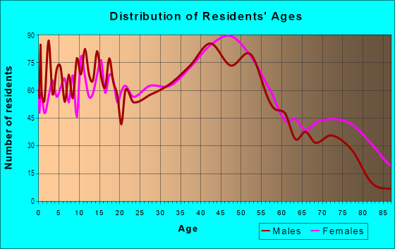
| Males: | 4,137 |
| Females: | 4,240 |
Males:
| This neighborhood: | 42.8 years |
| Whole city: | 39.7 years |
| This neighborhood: | 48.5 years |
| Whole city: | 41.9 years |
Average household size:
| Perry Heights (Perry Hts.): | 2.3 people |
| Massillon: | 2.2 people |
Percentage of family households:
| Perry Heights (Perry Hts.): | 49.0% |
| Massillon: | 43.2% |
| Here: | 39.3% |
| Massillon: | 39.0% |
Percentage of married-couple families with children (among all households):
| Perry Heights (Perry Hts.): | 22.4% |
| Massillon: | 23.1% |
Percentage of single-mother households (among all households):
| Perry Heights (Perry Hts.): | 21.6% |
| Massillon: | 14.2% |
Percentage of never married males 15 years old and over:
Percentage of never married females 15 years old and over:
| Perry Heights (Perry Hts.): | 22.1% |
| Massillon: | 17.6% |
Percentage of never married females 15 years old and over:
| Perry Heights (Perry Hts.): | 16.3% |
| city: | 14.6% |
Percentage of people that speak English not well or not at all:
| Perry Heights (Perry Hts.): | 1.1% |
| Massillon: | 0.3% |
Percentage of people born in this state:
Percentage of people born in another U.S. state:
Percentage of native residents but born outside the U.S.:
Percentage of foreign born residents:
| Here: | 86.7% |
| Massillon: | 84.9% |
Percentage of people born in another U.S. state:
| Perry Heights (Perry Hts.): | 9.9% |
| Massillon: | 13.4% |
Percentage of native residents but born outside the U.S.:
| Here: | 1.1% |
| city: | 0.3% |
Percentage of foreign born residents:
| Here: | 2.3% |
| Massillon: | 1.4% |

Owner-occupied
Renter-occupied


- Rooms in owner-occupied houses and condos in Perry Heights <
> - 141 room
- 02 rooms
- 663 rooms
- 4894 rooms
- 4265 rooms
- 4206 rooms
- 3807 rooms
- 3268 rooms
- 3259+ rooms

- Rooms in renter-occupied apartments in Perry Heights <
> - 91 room
- 82 rooms
- 773 rooms
- 7514 rooms
- 2805 rooms
- 4366 rooms
- 747 rooms
- 1698 rooms
- 609+ rooms
Owner-occupied
Renter-occupied

- Bedrooms in owner-occupied houses and condos in Perry Heights <
> - 14no bedroom
- 541 bedroom
- 5922 bedrooms
- 1,1693 bedrooms
- 1724 bedrooms
- 3465+ bedrooms

- Bedrooms in renter-occupied apartments in Perry Heights <
> - 9no bedroom
- 1921 bedroom
- 6672 bedrooms
- 3223 bedrooms
- 514 bedrooms
- 05+ bedrooms
Average number of cars or other vehicles available in houses/condos:
Average number of cars or other vehicles available in apartments:
| This neighborhood: | 2.1 |
| Massillon: | 2.0 |
Average number of cars or other vehicles available in apartments:
| Here: | 1.6 |
| city: | 1.3 |
Percentage of units with a mortgage:
| Perry Heights (Perry Hts.): | 73.4% |
| Massillon: | 63.6% |
Average estimated value of detached houses in 2022 (76.0% of all units):
| Perry Heights (Perry Hts.): | $194,693 |
| Ohio: | $254,366 |

- Year house built in Perry Heights <
> - 272020 or later
- 1282010 to 2019
- 1002000 to 2009
- 3281990 to 1999
- 1441980 to 1989
- 6941970 to 1979
- 6801960 to 1969
- 8141950 to 1959
- 6741940 to 1949
- 4911939 or earlier

City-data.com crime index for city in 2020 (higher means more crime):
| City: | 180.9 |
| U.S. average: | 219.5 |
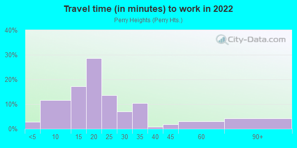
Travel time to work (commute)
![Travel time to work (commute)]()
- 89Less than 5 minutes
- 3745 to 9 minutes
- 55210 to 14 minutes
- 92315 to 19 minutes
- 44120 to 24 minutes
- 22425 to 29 minutes
- 33630 to 34 minutes
- 2835 to 39 minutes
- 5740 to 44 minutes
- 9445 to 59 minutes
- 11860 to 89 minutes
- 1690 or more minutes
Means of transportation to work
![Means of transportation to work]()
- 84.2%3,579Drove a car alone
- 3.4%143Carpooled
- 1.6%70Bus
- 2.3%99Walked
- 4.0%171Other means
- 9.8%415Worked at home

Time leaving home to go to work
![Time leaving home to go to work]()
- 11912:00 a.m. to 4:59 a.m.
- 1235:00 a.m. to 5:29 a.m.
- 645:30 a.m. to 5:59 a.m.
- 2156:00 a.m. to 6:29 a.m.
- 4286:30 a.m. to 6:59 a.m.
- 5697:00 a.m. to 7:29 a.m.
- 3437:30 a.m. to 7:59 a.m.
- 1568:00 a.m. to 8:29 a.m.
- 1168:30 a.m. to 8:59 a.m.
- 1599:00 a.m. to 9:59 a.m.
- 6610:00 a.m. to 10:59 a.m.
- 10411:00 a.m. to 11:59 a.m.
- 32612:00 p.m. to 3:59 p.m.
- 4304:00 p.m. to 11:59 p.m.

Occupations of males:
- Percentage of males in management occupations (except farmers):
Here: 10.5% city: 11.6%
- Percentage of males in computer and mathematical occupations:
Here: 3.9% city: 2.0%
- Percentage of males in life, physical, and social science occupations:
Here: 2.2% city: 0.3%
- Percentage of males in arts, design, entertainment, sports, and media occupations:
Here: 2.4% city: 0.7%
- Percentage of males in service occupations:
Here: 27.4% city: 14.4%
- Percentage of males in sales and office occupations:
Here: 5.6% city: 14.1%
- Percentage of males in construction, extraction, and maintenance occupations:
Here: 10.9% city: 5.2%
- Percentage of males in production occupations:
Here: 11.7% city: 16.4%
- Percentage of males in transportation occupations:
Here: 10.2% city: 7.4%
- Percentage of males in material moving occupations:
Here: 6.6% city: 12.9%
Occupations of females:
- Percentage of females in management occupations (except farmers):
Here: 7.1% city: 6.4%
- Percentage of females in business and financial operations occupations:
Here: 3.5% city: 4.7%
- Percentage of females in education, training, and library occupations:
Here: 2.4% city: 8.1%
- Percentage of females in arts, design, entertainment, sports, and media occupations:
Here: 1.8% city: 1.3%
- Percentage of females in healthcare practitioners and technical occupations:
Here: 14.1% city: 6.6%
- Percentage of females in service occupations:
Here: 30.1% city: 28.1%
- Percentage of females in sales and office occupations:
Here: 23.0% city: 30.1%
- Percentage of females in production occupations:
Here: 12.3% city: 5.3%
- Percentage of females in material moving occupations:
Here: 5.1% city: 1.8%
Education in this neighborhood (subdivision or community):
- Percentage of people 3 years and older in K-12 schools:
Perry Heights (Perry Hts.): 26.5% Massillon: 15.5%
- Percentage of people 3 years and older in undergraduate colleges:
Perry Heights (Perry Hts.): 4.0% Massillon: 3.0%
- Percentage of people 3 years and older in grad. or professional schools:
Perry Heights (Perry Hts.): 8.2% Massillon: 0.6%
- Percentage of students K-12 enrolled in private schools:
Perry Heights (Perry Hts.): 16.9% Massillon: 10.0%
Percentage of population below poverty level:
| Perry Heights (Perry Hts.): | 12.5% |
| Massillon: | 14.5% |
Median year owner moved in (as recorded in 2022):
| Perry Heights (Perry Hts.): | 2005 |
| Massillon: | 2007 |
Percentage of married-couple families with both working:
| Perry Heights (Perry Hts.): | 101.3% |
| Massillon: | 82.9% |

- 89.0%Utility gas
- 7.1%Electricity
- 1.7%Bottled, tank, or LP gas
- 1.3%Fuel oil, kerosene, etc.
- 1.0%Wood
Highways in this neighborhood:
State Hwy 172 (Lincoln Way E)
Length: 2.42 miles
Direction: E-W
Address range: 2700 to 4699
Direction: E-W
Address range: 2700 to 4699
State Hwy 172 (Tuscarawas St W)
Length: 0.26 miles
Direction: E-W
Address range: 5100 to 5231
Direction: E-W
Address range: 5100 to 5231
Roads and streets:
12th St NW (240)
Length: 2.48 miles
Directions: E-W, SW-NE
Address range: 2800 to 6059
Directions: E-W, SW-NE
Address range: 2800 to 6059
223 (4th St NW)
Length: 1.69 miles
Directions: E-W, N-S, SE-NW
Address range: 100 to 5299
Directions: E-W, N-S, SE-NW
Address range: 100 to 5299
Bailey St NW
Length: 1.51 miles
Directions: E-W, N-S, SE-NW
Address range: 2700 to 4199
Directions: E-W, N-S, SE-NW
Address range: 2700 to 4199
13th St SW (1457)
Length: 1.33 miles
Direction: E-W
Address range: 5100 to 5399
Direction: E-W
Address range: 5100 to 5399
Genoa Ave NW
Length: 1.23 miles
Direction: N-S
Address range: 100 to 1399
Direction: N-S
Address range: 100 to 1399
Marion Ave NW
Length: 1.10 miles
Directions: E-W, N-S, SW-NE
Address range: 100 to 1149
Directions: E-W, N-S, SW-NE
Address range: 100 to 1149
2607 (Summerdale Ave NW)
Length: 1.06 miles
Directions: E-W, N-S, SE-NW, SW-NE
Address range: 500 to 1399
Directions: E-W, N-S, SE-NW, SW-NE
Address range: 500 to 1399
Hilton St NW (1384)
Length: 0.95 miles
Directions: E-W, SE-NW
Address range: 2900 to 3599
Directions: E-W, SE-NW
Address range: 2900 to 3599
1419 (12th St SW)
Length: 0.79 miles
Direction: E-W
Address range: 3730 to 5250
Direction: E-W
Address range: 3730 to 5250
Meadowood St NW (1371)
Length: 0.74 miles
Directions: E-W, SW-NE
Address range: 2900 to 3499
Directions: E-W, SW-NE
Address range: 2900 to 3499
2621 (Georgia St NW)
Length: 0.74 miles
Directions: E-W, N-S, SE-NW
Address range: 3700 to 4299
Directions: E-W, N-S, SE-NW
Address range: 3700 to 4299
27th St NE
Length: 0.74 miles
Direction: N-S
Address range: 600 to 1199
Direction: N-S
Address range: 600 to 1199
1409 (Roxbury Ave NW)
Length: 0.73 miles
Directions: E-W, N-S, SE-NW
Address range: 100 to 699
Directions: E-W, N-S, SE-NW
Address range: 100 to 699
Pine Hills Dr SW (2623)
Length: 0.71 miles
Directions: E-W, N-S, SE-NW, SW-NE
Address range: 700 to 3299
Directions: E-W, N-S, SE-NW, SW-NE
Address range: 700 to 3299
1414 (Stewart Ave SW)
Length: 0.71 miles
Directions: N-S, SE-NW
Address range: 100 to 599
Directions: N-S, SE-NW
Address range: 100 to 599
Mollane St NW (1422)
Length: 0.67 miles
Directions: E-W, SW-NE
Address range: 3300 to 3899
Directions: E-W, SW-NE
Address range: 3300 to 3899
1416 (Harding Ave NW)
Length: 0.60 miles
Directions: N-S, SW-NE
Address range: 100 to 638
Directions: N-S, SW-NE
Address range: 100 to 638
Crown Point St NW (2902)
Length: 0.59 miles
Directions: E-W, N-S, SE-NW, SW-NE
Address range: 3200 to 3599
Directions: E-W, N-S, SE-NW, SW-NE
Address range: 3200 to 3599
1411 (Foch St NW)
Length: 0.58 miles
Directions: E-W, SW-NE
Address range: 4000 to 4623
Directions: E-W, SW-NE
Address range: 4000 to 4623
1466 (27th St SE)
Length: 0.58 miles
Direction: N-S
Address range: 100 to 725
Direction: N-S
Address range: 100 to 725
243 (Genoa Ave SW)
Length: 0.56 miles
Direction: N-S
Address range: 119 to 899
Direction: N-S
Address range: 119 to 899
1397 (Kolpwood Ave NW)
Length: 0.55 miles
Direction: N-S
Address range: 100 to 899
Direction: N-S
Address range: 100 to 899
1415 (Locke Ave SW)
Length: 0.54 miles
Directions: E-W, N-S, SE-NW
Address range: 100 to 599
Directions: E-W, N-S, SE-NW
Address range: 100 to 599
1399 (Snively Ave NW)
Length: 0.53 miles
Direction: N-S
Address range: 100 to 899
Direction: N-S
Address range: 100 to 899
Crescentview Dr SW (1379)
Length: 0.53 miles
Directions: E-W, N-S, SE-NW, SW-NE
Address range: 100 to 3198
Directions: E-W, N-S, SE-NW, SW-NE
Address range: 100 to 3198
Harsh Ave SE (1391)
Length: 0.52 miles
Directions: E-W, SW-NE
Address range: 2770 to 3321
Directions: E-W, SW-NE
Address range: 2770 to 3321
Westland Ave SW (1413)
Length: 0.51 miles
Direction: N-S
Address range: 100 to 599
Direction: N-S
Address range: 100 to 599
Buckwalter Dr SW (2239)
Length: 0.50 miles
Directions: E-W, N-S, SE-NW, SW-NE
Address range: 550 to 3398
Directions: E-W, N-S, SE-NW, SW-NE
Address range: 550 to 3398
Shoreline Ave NW (3647)
Length: 0.49 miles
Directions: E-W, N-S, SE-NW, SW-NE
Address range: 100 to 199
Directions: E-W, N-S, SE-NW, SW-NE
Address range: 100 to 199
Perry Dr SW (225)
Length: 0.48 miles
Direction: N-S
Address range: 100 to 1535
Direction: N-S
Address range: 100 to 1535
Rowford Ave SW
Length: 0.48 miles
Directions: E-W, N-S, SE-NW, SW-NE
Address range: 100 to 3099
Directions: E-W, N-S, SE-NW, SW-NE
Address range: 100 to 3099
3552 (Burlawn St NW)
Length: 0.48 miles
Directions: E-W, N-S, SE-NW
Address range: 5113 to 5368
Directions: E-W, N-S, SE-NW
Address range: 5113 to 5368
2615 (Pheasant Grove Ave NW)
Length: 0.48 miles
Directions: N-S, SW-NE
Address range: 600 to 1056
Directions: N-S, SW-NE
Address range: 600 to 1056
3110 (Canford Ave NW)
Length: 0.48 miles
Directions: E-W, N-S, SE-NW
Address range: 400 to 749
Directions: E-W, N-S, SE-NW
Address range: 400 to 749
3344 (Banyan St NW)
Length: 0.47 miles
Directions: E-W, SE-NW, SW-NE
Address range: 3300 to 3599
Directions: E-W, SE-NW, SW-NE
Address range: 3300 to 3599
Rowmont Rd SW (1380)
Length: 0.47 miles
Directions: E-W, N-S, SW-NE
Address range: 100 to 3198
Directions: E-W, N-S, SW-NE
Address range: 100 to 3198
Shelia St NW (3335)
Length: 0.46 miles
Directions: E-W, SW-NE
Address range: 2900 to 3199
Directions: E-W, SW-NE
Address range: 2900 to 3199
Netherwood Ave NW (3555)
Length: 0.46 miles
Directions: E-W, N-S, SE-NW, SW-NE
Address range: 400 to 1024
Directions: E-W, N-S, SE-NW, SW-NE
Address range: 400 to 1024
1405 (Albany Dr NW)
Length: 0.43 miles
Directions: N-S, SE-NW, SW-NE
Address range: 161 to 399
Directions: N-S, SE-NW, SW-NE
Address range: 161 to 399
Marta St SW (2240)
Length: 0.43 miles
Direction: E-W
Address range: 3000 to 3199
Direction: E-W
Address range: 3000 to 3199
Severn Cir NW
Length: 0.42 miles
Directions: E-W, N-S, SE-NW, SW-NE
Address range: 5400 to 5699
Directions: E-W, N-S, SE-NW, SW-NE
Address range: 5400 to 5699
241 (Mill Ridge Path NE)
Length: 0.42 miles
Directions: E-W, N-S, SW-NE
Address range: 900 to 2999
Directions: E-W, N-S, SW-NE
Address range: 900 to 2999
1401 (Elizabeth Ave SW)
Length: 0.41 miles
Direction: N-S
Address range: 100 to 599
Direction: N-S
Address range: 100 to 599
Greenpark St NW (2612)
Length: 0.41 miles
Directions: E-W, N-S, SE-NW
Address range: 3018 to 3299
Directions: E-W, N-S, SE-NW
Address range: 3018 to 3299
14th St SW (1468)
Length: 0.39 miles
Direction: E-W
Address range: 5100 to 5299
Direction: E-W
Address range: 5100 to 5299
1390 (Lennox Ave NW)
Length: 0.38 miles
Direction: N-S
Address range: 101 to 399
Direction: N-S
Address range: 101 to 399
Tanya Ave NW (3445)
Length: 0.38 miles
Directions: N-S, SW-NE
Address range: 240 to 742
Directions: N-S, SW-NE
Address range: 240 to 742
Bernower Ave SW (1402)
Length: 0.38 miles
Direction: N-S
Address range: 100 to 549
Direction: N-S
Address range: 100 to 549
Connecticut St SW (1375)
Length: 0.37 miles
Direction: E-W
Address range: 2800 to 3099
Direction: E-W
Address range: 2800 to 3099
Jeffrey Ave NW
Length: 0.35 miles
Directions: N-S, SE-NW
Address range: 500 to 818
Directions: N-S, SE-NW
Address range: 500 to 818
1403 (Gnau Ave SW)
Length: 0.35 miles
Direction: N-S
Address range: 100 to 599
Direction: N-S
Address range: 100 to 599
Overmont Ave SW
Length: 0.33 miles
Direction: N-S
Address range: 100 to 507
Direction: N-S
Address range: 100 to 507
Pershing Ave NW (1410)
Length: 0.32 miles
Direction: N-S
Address range: 100 to 399
Direction: N-S
Address range: 100 to 399
Conover St NW
Length: 0.32 miles
Directions: E-W, SE-NW
Address range: 3000 to 3199
Directions: E-W, SE-NW
Address range: 3000 to 3199
Lennox Ave SW
Length: 0.32 miles
Direction: N-S
Address range: 100 to 599
Direction: N-S
Address range: 100 to 599
Windamere Ave NW
Length: 0.31 miles
Directions: N-S, SE-NW
Address range: 431 to 628
Directions: N-S, SE-NW
Address range: 431 to 628
Linway Ave NW (1424)
Length: 0.31 miles
Direction: N-S
Address range: 100 to 499
Direction: N-S
Address range: 100 to 499
1386 (Freeman Ave NW)
Length: 0.31 miles
Direction: N-S
Address range: 100 to 451
Direction: N-S
Address range: 100 to 451
Ingall Ave NW
Length: 0.31 miles
Direction: N-S
Address range: 100 to 499
Direction: N-S
Address range: 100 to 499
442 (Tyner St NW)
Length: 0.31 miles
Directions: E-W, SE-NW
Address range: 5100 to 5299
Directions: E-W, SE-NW
Address range: 5100 to 5299
3553 (Arrowbrook St NW)
Length: 0.31 miles
Direction: E-W
Address range: 5100 to 5299
Direction: E-W
Address range: 5100 to 5299
Elmford Ave SW (1381)
Length: 0.31 miles
Direction: N-S
Address range: 100 to 599
Direction: N-S
Address range: 100 to 599
1407 (Dupont St NW)
Length: 0.30 miles
Direction: E-W
Address range: 4300 to 4599
Direction: E-W
Address range: 4300 to 4599
Edgewater Ave NW (1406)
Length: 0.30 miles
Direction: N-S
Address range: 100 to 399
Direction: N-S
Address range: 100 to 399
1393 (Avis Ave NW)
Length: 0.30 miles
Direction: N-S
Address range: 100 to 454
Direction: N-S
Address range: 100 to 454
1395 (Austin Ave NW)
Length: 0.30 miles
Direction: N-S
Address range: 100 to 499
Direction: N-S
Address range: 100 to 499
1408 (Eden Ave NW)
Length: 0.29 miles
Direction: N-S
Address range: 100 to 399
Direction: N-S
Address range: 100 to 399
1420 (Wrexham Ave SW)
Length: 0.29 miles
Direction: N-S
Address range: 100 to 599
Direction: N-S
Address range: 100 to 599
Hinderer Ave SW
Length: 0.29 miles
Direction: N-S
Address range: 100 to 599
Direction: N-S
Address range: 100 to 599
2616 (Carolina St NW)
Length: 0.29 miles
Direction: E-W
Address range: 3600 to 3799
Direction: E-W
Address range: 3600 to 3799
Edgewood Ave SW
Length: 0.28 miles
Direction: N-S
Address range: 600 to 761
Direction: N-S
Address range: 600 to 761
Leonard Ave NW (1503)
Length: 0.28 miles
Directions: N-S, SE-NW
Address range: 100 to 402
Directions: N-S, SE-NW
Address range: 100 to 402
1418 (Highland Ave SW)
Length: 0.28 miles
Direction: N-S
Address range: 100 to 599
Direction: N-S
Address range: 100 to 599
Bellarbor Ave NW (3556)
Length: 0.28 miles
Directions: N-S, SE-NW
Address range: 620 to 1037
Directions: N-S, SE-NW
Address range: 620 to 1037
Tillman St NW (2617)
Length: 0.28 miles
Directions: E-W, SW-NE
Address range: 3600 to 3799
Directions: E-W, SW-NE
Address range: 3600 to 3799
Fairlawn Ave SW (1417)
Length: 0.28 miles
Direction: N-S
Address range: 100 to 599
Direction: N-S
Address range: 100 to 599
Woodrich St SW (2624)
Length: 0.27 miles
Directions: E-W, N-S, SE-NW, SW-NE
Address range: 700 to 3199
Directions: E-W, N-S, SE-NW, SW-NE
Address range: 700 to 3199
Jackson Ave NW
Length: 0.27 miles
Direction: N-S
Address range: 200 to 599
Direction: N-S
Address range: 200 to 599
Harding Ave SW (1416)
Length: 0.26 miles
Direction: N-S
Address range: 121 to 526
Direction: N-S
Address range: 121 to 526
Charldon Ave SW
Length: 0.26 miles
Directions: N-S, SW-NE
Address range: 600 to 751
Directions: N-S, SW-NE
Address range: 600 to 751
Belle Ave NW (1421)
Length: 0.25 miles
Direction: N-S
Address range: 100 to 499
Direction: N-S
Address range: 100 to 499
Cooper Ave SW (2281)
Length: 0.25 miles
Directions: E-W, N-S, SE-NW, SW-NE
Address range: 200 to 302
Directions: E-W, N-S, SE-NW, SW-NE
Address range: 200 to 302
Sippo Ave SW
Length: 0.25 miles
Direction: N-S
Address range: 100 to 1399
Direction: N-S
Address range: 100 to 1399
Swepstone St NW (3557)
Length: 0.24 miles
Direction: E-W
Address range: 5270 to 5405
Direction: E-W
Address range: 5270 to 5405
Parkland Ave SW
Length: 0.24 miles
Direction: N-S
Address range: 100 to 349
Direction: N-S
Address range: 100 to 349
Gray Ridge Ave SE
Length: 0.23 miles
Directions: E-W, SE-NW
Directions: E-W, SE-NW
3545 (Partridge St NW)
Length: 0.23 miles
Direction: E-W
Address range: 3400 to 3521
Direction: E-W
Address range: 3400 to 3521
1423 (Montrose Ave NW)
Length: 0.23 miles
Directions: N-S, SE-NW
Address range: 400 to 627
Directions: N-S, SE-NW
Address range: 400 to 627
2610 (Citadel Ave NW)
Length: 0.22 miles
Directions: N-S, SE-NW, SW-NE
Address range: 900 to 1099
Directions: N-S, SE-NW, SW-NE
Address range: 900 to 1099
Leonard Ave SW (1412)
Length: 0.22 miles
Direction: N-S
Address range: 100 to 599
Direction: N-S
Address range: 100 to 599
Cinwood Ave NW (4192)
Length: 0.22 miles
Direction: E-W
Address range: 3800 to 4099
Direction: E-W
Address range: 3800 to 4099
3346 (Bayberry Dr NW)
Length: 0.22 miles
Directions: E-W, N-S, SE-NW
Address range: 800 to 955
Directions: E-W, N-S, SE-NW
Address range: 800 to 955
1464 (Zern Ave SW)
Length: 0.22 miles
Direction: N-S
Address range: 100 to 599
Direction: N-S
Address range: 100 to 599
3399 (Brook Ave NW)
Length: 0.21 miles
Directions: N-S, SW-NE
Address range: 1000 to 1333
Directions: N-S, SW-NE
Address range: 1000 to 1333
Proudley Ave SW (3170)
Length: 0.21 miles
Direction: N-S
Address range: 101 to 599
Direction: N-S
Address range: 101 to 599
2672 (Elmbreeze St NW)
Length: 0.21 miles
Direction: E-W
Address range: 2700 to 2849
Direction: E-W
Address range: 2700 to 2849
2620 (Delford Ave NW)
Length: 0.20 miles
Directions: N-S, SE-NW, SW-NE
Address range: 500 to 620
Directions: N-S, SE-NW, SW-NE
Address range: 500 to 620
Wattova Rd NW (2423)
Length: 0.20 miles
Directions: E-W, N-S, SW-NE
Address range: 3000 to 3199
Directions: E-W, N-S, SW-NE
Address range: 3000 to 3199
Singing Brook Ave NW
Length: 0.20 miles
Direction: N-S
Address range: 1100 to 1299
Direction: N-S
Address range: 1100 to 1299
Lynch St SW
Length: 0.19 miles
Directions: E-W, SE-NW
Address range: 3100 to 3299
Directions: E-W, SE-NW
Address range: 3100 to 3299
Newport Ave NW (1394)
Length: 0.19 miles
Direction: N-S
Address range: 100 to 399
Direction: N-S
Address range: 100 to 399
Bayer Cir NW (1398)
Length: 0.19 miles
Directions: E-W, N-S, SE-NW, SW-NE
Address range: 3000 to 3035
Directions: E-W, N-S, SE-NW, SW-NE
Address range: 3000 to 3035
3542 (Norwich Ave NW)
Length: 0.19 miles
Directions: E-W, N-S, SW-NE
Address range: 939 to 1041
Directions: E-W, N-S, SW-NE
Address range: 939 to 1041
Star Ridge St SE
Length: 0.18 miles
Directions: E-W, N-S, SE-NW
Directions: E-W, N-S, SE-NW
Prescot Ave NW (4064)
Length: 0.18 miles
Directions: E-W, N-S, SE-NW
Address range: 900 to 1199
Directions: E-W, N-S, SE-NW
Address range: 900 to 1199
Meadowridge Ave NW
Length: 0.17 miles
Directions: N-S, SW-NE
Address range: 500 to 720
Directions: N-S, SW-NE
Address range: 500 to 720
Minuteman Ave NW (4063)
Length: 0.17 miles
Direction: N-S
Address range: 900 to 1199
Direction: N-S
Address range: 900 to 1199
1389 (Dalecrest St NW)
Length: 0.17 miles
Direction: E-W
Address range: 3400 to 3499
Direction: E-W
Address range: 3400 to 3499
Lewis Ct NW
Length: 0.17 miles
Direction: E-W
Direction: E-W
3547 (Rachel Cir NW)
Length: 0.17 miles
Directions: E-W, N-S, SW-NE
Address range: 500 to 599
Directions: E-W, N-S, SW-NE
Address range: 500 to 599
Spindle St NW (3345)
Length: 0.17 miles
Direction: E-W
Address range: 3436 to 3544
Direction: E-W
Address range: 3436 to 3544
Wattova Dr NW
Length: 0.16 miles
Direction: E-W
Address range: 2900 to 3007
Direction: E-W
Address range: 2900 to 3007
Cliffwood Ave NW (3644)
Length: 0.16 miles
Directions: N-S, SW-NE
Address range: 1100 to 1199
Directions: N-S, SW-NE
Address range: 1100 to 1199
Maytime St NW (3448)
Length: 0.16 miles
Direction: E-W
Address range: 3000 to 3129
Direction: E-W
Address range: 3000 to 3129
Holodale St SW
Length: 0.16 miles
Directions: E-W, SE-NW
Address range: 3000 to 3099
Directions: E-W, SE-NW
Address range: 3000 to 3099
4062 (Bunker Hill St NW)
Length: 0.16 miles
Directions: E-W, SE-NW
Address range: 3600 to 3699
Directions: E-W, SE-NW
Address range: 3600 to 3699
Russ Ranch St NW
Length: 0.15 miles
Direction: E-W
Address range: 3200 to 3299
Direction: E-W
Address range: 3200 to 3299
Rayanna St NW (2422)
Length: 0.15 miles
Directions: E-W, SW-NE
Address range: 3200 to 3299
Directions: E-W, SW-NE
Address range: 3200 to 3299
Pinewood Ave SW (2241)
Length: 0.15 miles
Directions: N-S, SW-NE
Address range: 600 to 699
Directions: N-S, SW-NE
Address range: 600 to 699
Colina Vista Ave NW
Length: 0.14 miles
Direction: SW-NE
Address range: 900 to 969
Direction: SW-NE
Address range: 900 to 969
Rohr Ave NW
Length: 0.13 miles
Direction: N-S
Address range: 100 to 399
Direction: N-S
Address range: 100 to 399
12th St NW (4321)
Length: 0.12 miles
Direction: E-W
Address range: 2632 to 2799
Direction: E-W
Address range: 2632 to 2799
Willwood St NW (2954)
Length: 0.12 miles
Direction: E-W
Address range: 3833 to 3875
Direction: E-W
Address range: 3833 to 3875
Shoreview Cir NW (4087)
Length: 0.12 miles
Directions: E-W, N-S, SE-NW
Address range: 5100 to 5199
Directions: E-W, N-S, SE-NW
Address range: 5100 to 5199
Pirates Cove St NW
Length: 0.12 miles
Direction: E-W
Address range: 4200 to 4247
Direction: E-W
Address range: 4200 to 4247
Ext
Length: 0.11 miles
Directions: N-S, SE-NW
Directions: N-S, SE-NW
Hilton St NW
Length: 0.11 miles
Directions: E-W, N-S, SE-NW
Directions: E-W, N-S, SE-NW
Lakeshore Cir NW
Length: 0.11 miles
Direction: E-W
Address range: 4300 to 4428
Direction: E-W
Address range: 4300 to 4428
Ashby St NW
Length: 0.11 miles
Direction: E-W
Address range: 5300 to 5399
Direction: E-W
Address range: 5300 to 5399
Mill Creek Run NE
Length: 0.11 miles
Direction: E-W
Address range: 2700 to 2851
Direction: E-W
Address range: 2700 to 2851
3558 (Ridgeglen Cir NW)
Length: 0.11 miles
Direction: E-W
Address range: 5120 to 5170
Direction: E-W
Address range: 5120 to 5170
1376 (Wildwood Cir SW)
Length: 0.10 miles
Directions: E-W, N-S, SE-NW, SW-NE
Address range: 3159 to 3199
Directions: E-W, N-S, SE-NW, SW-NE
Address range: 3159 to 3199
Persia Cir SW (1377)
Length: 0.10 miles
Directions: E-W, N-S, SE-NW, SW-NE
Address range: 3265 to 3299
Directions: E-W, N-S, SE-NW, SW-NE
Address range: 3265 to 3299
1374 (Elizabeth Ave NW)
Length: 0.10 miles
Direction: N-S
Address range: 100 to 313
Direction: N-S
Address range: 100 to 313
Summitview Cir NW (3649)
Length: 0.10 miles
Direction: SE-NW
Address range: 5100 to 5199
Direction: SE-NW
Address range: 5100 to 5199
Rolena Cir NW
Length: 0.10 miles
Direction: N-S
Address range: 1116 to 1179
Direction: N-S
Address range: 1116 to 1179
1373 (Star Cir SW)
Length: 0.09 miles
Directions: E-W, N-S, SE-NW, SW-NE
Address range: 102 to 149
Directions: E-W, N-S, SE-NW, SW-NE
Address range: 102 to 149
242 (Jackson Ave NW)
Length: 0.09 miles
Direction: N-S
Direction: N-S
Tabor St SW
Length: 0.09 miles
Direction: E-W
Address range: 3500 to 3599
Direction: E-W
Address range: 3500 to 3599
Brockton Ave NW
Length: 0.09 miles
Direction: SW-NE
Address range: 952 to 998
Direction: SW-NE
Address range: 952 to 998
Seaview Cir NW (3651)
Length: 0.09 miles
Directions: E-W, SE-NW
Address range: 5100 to 5139
Directions: E-W, SE-NW
Address range: 5100 to 5139
Belmont Ave NW
Length: 0.08 miles
Directions: N-S, SW-NE
Address range: 3437 to 3449
Directions: N-S, SW-NE
Address range: 3437 to 3449
Bridgeton St NE
Length: 0.07 miles
Direction: E-W
Direction: E-W
4191 (Lorwood St NW)
Length: 0.07 miles
Direction: E-W
Address range: 3833 to 3867
Direction: E-W
Address range: 3833 to 3867
Sickels Cir SE
Length: 0.07 miles
Direction: E-W
Direction: E-W
Sippo Ave NW (1469)
Length: 0.07 miles
Direction: N-S
Address range: 200 to 299
Direction: N-S
Address range: 200 to 299
Ventura Cir NW (3115)
Length: 0.06 miles
Directions: E-W, SE-NW
Address range: 3100 to 3199
Directions: E-W, SE-NW
Address range: 3100 to 3199
Falcon Cir NW (4189)
Length: 0.06 miles
Directions: E-W, SE-NW
Address range: 4000 to 4099
Directions: E-W, SE-NW
Address range: 4000 to 4099
Beachview Cir NW (3650)
Length: 0.06 miles
Direction: E-W
Address range: 5100 to 5331
Direction: E-W
Address range: 5100 to 5331
Kitzmiller Ave SW (3171)
Length: 0.06 miles
Direction: E-W
Address range: 3300 to 3314
Direction: E-W
Address range: 3300 to 3314
Kingston Ave NW
Length: 0.06 miles
Directions: N-S, SE-NW, SW-NE
Address range: 329 to 360
Directions: N-S, SE-NW, SW-NE
Address range: 329 to 360
Barrington Cir SE
Length: 0.06 miles
Direction: N-S
Direction: N-S
Tyner St NW
Length: 0.06 miles
Direction: E-W
Address range: 5300 to 5399
Direction: E-W
Address range: 5300 to 5399
Connecticut Ave SE (1375)
Length: 0.05 miles
Direction: E-W
Address range: 2700 to 2799
Direction: E-W
Address range: 2700 to 2799
Seifert Ct NW
Length: 0.05 miles
Direction: E-W
Address range: 100 to 199
Direction: E-W
Address range: 100 to 199
Harsh Ave SE (1278)
Length: 0.05 miles
Direction: E-W
Address range: 2700 to 2769
Direction: E-W
Address range: 2700 to 2769
Mallard Cir NW (3546)
Length: 0.05 miles
Direction: N-S
Address range: 700 to 736
Direction: N-S
Address range: 700 to 736
Waterline Cir NW (3648)
Length: 0.04 miles
Direction: E-W
Address range: 5200 to 5299
Direction: E-W
Address range: 5200 to 5299
Grouse Cir NW (3397)
Length: 0.04 miles
Direction: SE-NW
Address range: 763 to 780
Direction: SE-NW
Address range: 763 to 780
2902 (Crownpoint St NW)
Length: 0.04 miles
Direction: E-W
Address range: 3209 to 3599
Direction: E-W
Address range: 3209 to 3599
4321 (Boron St NW)
Length: 0.04 miles
Direction: E-W
Address range: 2794 to 2830
Direction: E-W
Address range: 2794 to 2830
Kitzmiller St SW (1379)
Length: 0.04 miles
Direction: E-W
Address range: 3308 to 3315
Direction: E-W
Address range: 3308 to 3315
3398 (Winter Hills Cir NW)
Length: 0.04 miles
Direction: E-W
Address range: 3300 to 3343
Direction: E-W
Address range: 3300 to 3343
Lighthouse Cir NW
Length: 0.04 miles
Direction: SW-NE
Address range: 4200 to 4263
Direction: SW-NE
Address range: 4200 to 4263
Southview Cir NW
Length: 0.03 miles
Directions: E-W, SW-NE
Address range: 1140 to 1151
Directions: E-W, SW-NE
Address range: 1140 to 1151
Shoreway Cir NW
Length: 0.03 miles
Direction: N-S
Address range: 600 to 699
Direction: N-S
Address range: 600 to 699
Willowlane Cir NW (2143)
Length: 0.03 miles
Direction: N-S
Address range: 1200 to 1249
Direction: N-S
Address range: 1200 to 1249
Harsh St SW
Length: 0.03 miles
Direction: E-W
Address range: 3050 to 3075
Direction: E-W
Address range: 3050 to 3075
3544 (Bridgeton St NW)
Length: 0.03 miles
Direction: E-W
Address range: 2912 to 2970
Direction: E-W
Address range: 2912 to 2970
Bridgton Ave NE
Length: 0.03 miles
Direction: E-W
Address range: 2906 to 2914
Direction: E-W
Address range: 2906 to 2914
3544 (Bridgton St NW)
Length: 0.02 miles
Directions: E-W, SE-NW
Address range: 2900 to 2999
Directions: E-W, SE-NW
Address range: 2900 to 2999
Bass Cir NW
Length: 0.02 miles
Direction: N-S
Address range: 1100 to 1199
Direction: N-S
Address range: 1100 to 1199
2626 (5th St NW)
Length: 0.02 miles
Direction: E-W
Address range: 5200 to 5299
Direction: E-W
Address range: 5200 to 5299
Railroad features:
Conrail RR
Length: 2.72 miles
Direction: E-W
Direction: E-W
Other features:
Sippo Crk
Length: 2.62 miles
Directions: E-W, N-S, SE-NW, SW-NE
Directions: E-W, N-S, SE-NW, SW-NE