Ocean Crest neighborhood in San Diego, California (CA), 92154 detailed profile
Settings
X


Business Search - 14 Million verified businesses
Area: 2.946 square miles
Population: 22,530
Population density:
| Ocean Crest: | 7,648 people per square mile |
| San Diego: | 4,258 people per square mile |

- 15,62268.1%Hispanic or Latino
- 3,42314.9%Asian
- 1,5576.8%White
- 9874.3%Black
- 9434.1%Two or more races
- 3661.6%Native Hawaiian and Other
Pacific Islander - 420.2%Some other race

Median household income in 2022:
| Ocean Crest: | $95,754 |
| San Diego: | $100,010 |
Distribution of median household income
![Distribution of median household income]()
- 307Less than $10,000
- 456$10,000 to $19,999
- 237$20,000 to $29,999
- 335$30,000 to $39,999
- 845$40,000 to $49,999
- 366$50,000 to $59,999
- 445$60,000 to $74,999
- 1,329$75,000 to $99,999
- 771$100,000 to $124,999
- 546$125,000 to $149,999
- 1,052$150,000 to $199,999
- 683$200,000 or more

Distribution of owner-occupied house/condo value
![Distribution of owner-occupied house/condo value]()
- 323Less than $50,000
- 60$50,000 to $99,999
- 177$150,000 to $199,999
- 59$200,000 to $249,999
- 6$250,000 to $299,999
- 167$300,000 to $399,999
- 1,499$400,000 to $499,999
- 3,375$500,000 to $749,999
- 266$750,000 to $999,999
- 9$1,000,000 or more

Distribution of rent paid by renters
![Distribution of rent paid by renters]()
- 25$500 to $599
- 23$700 to $799
- 282$1,500 to $1,999
- 490$2,000 or more

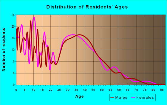
| Males: | 11,039 |
| Females: | 11,491 |
Males:
| This neighborhood: | 32.6 years |
| Whole city: | 35.4 years |
| This neighborhood: | 39.5 years |
| Whole city: | 37.2 years |
Average household size:
| Ocean Crest: | 14.9 people |
| San Diego: | 2.5 people |
Percentage of family households:
| Ocean Crest: | 54.7% |
| San Diego: | 41.7% |
| Here: | 64.5% |
| San Diego: | 43.2% |
Percentage of married-couple families with children (among all households):
| Ocean Crest: | 23.8% |
| San Diego: | 27.8% |
Percentage of single-mother households (among all households):
| Ocean Crest: | 3.9% |
| San Diego: | 7.9% |
Percentage of never married males 15 years old and over:
Percentage of never married females 15 years old and over:
| Ocean Crest: | 15.4% |
| San Diego: | 23.4% |
Percentage of never married females 15 years old and over:
| Ocean Crest: | 14.8% |
| city: | 18.8% |
Percentage of people that speak English not well or not at all:
| Ocean Crest: | 5.2% |
| San Diego: | 5.9% |
Percentage of people born in this state:
Percentage of people born in another U.S. state:
Percentage of native residents but born outside the U.S.:
Percentage of foreign born residents:
| Here: | 54.6% |
| San Diego: | 48.1% |
Percentage of people born in another U.S. state:
| Ocean Crest: | 13.7% |
| San Diego: | 24.9% |
Percentage of native residents but born outside the U.S.:
| Here: | 3.5% |
| city: | 2.4% |
Percentage of foreign born residents:
| Here: | 28.2% |
| San Diego: | 24.6% |

Owner-occupied
Renter-occupied


- Rooms in owner-occupied houses and condos in Ocean Crest
- 2091 room
- 02 rooms
- 863 rooms
- 1,0284 rooms
- 1,0105 rooms
- 1,1816 rooms
- 8407 rooms
- 7578 rooms
- 4829+ rooms

- Rooms in renter-occupied apartments in Ocean Crest
- 541 room
- 832 rooms
- 3913 rooms
- 2094 rooms
- 2175 rooms
- 2316 rooms
- 1777 rooms
- 858 rooms
- 499+ rooms
Owner-occupied
Renter-occupied

- Bedrooms in owner-occupied houses and condos in Ocean Crest
- 209no bedroom
- 01 bedroom
- 1892 bedrooms
- 2,6683 bedrooms
- 1,6664 bedrooms
- 7955+ bedrooms

- Bedrooms in renter-occupied apartments in Ocean Crest
- 54no bedroom
- 1491 bedroom
- 3242 bedrooms
- 2663 bedrooms
- 2224 bedrooms
- 1585+ bedrooms
Average number of cars or other vehicles available in houses/condos:
Average number of cars or other vehicles available in apartments:
| This neighborhood: | 1.7 |
| San Diego: | 2.1 |
Average number of cars or other vehicles available in apartments:
| Here: | 2.4 |
| city: | 1.6 |
Percentage of units with a mortgage:
| Ocean Crest: | 76.1% |
| San Diego: | 69.2% |
Average estimated value of detached houses in 2022 (97.0% of all units):
| Ocean Crest: | $545,706 |
| San Diego: | $1,227,596 |

- Year house built in Ocean Crest
- 02020 or later
- 02010 to 2019
- 1132000 to 2009
- 2761990 to 1999
- 1,8441980 to 1989
- 2,4281970 to 1979
- 1,7971960 to 1969
- 1461950 to 1959
- 511940 to 1949
- 01939 or earlier

City-data.com crime index for city in 2020 (higher means more crime):
| City: | 197.8 |
| U.S. average: | 219.5 |
Travel time to work (commute)
![Travel time to work (commute)]()
- 18Less than 5 minutes
- 465 to 9 minutes
- 21210 to 14 minutes
- 19015 to 19 minutes
- 16020 to 24 minutes
- 16125 to 29 minutes
- 43730 to 34 minutes
- 10335 to 39 minutes
- 18440 to 44 minutes
- 1,12545 to 59 minutes
- 22260 to 89 minutes
- 6990 or more minutes

Means of transportation to work
![Means of transportation to work]()
- 77.7%8,677Drove a car alone
- 10.5%1,173Carpooled
- 4.2%471Bus
- 0.9%102Subway or elevated rail
- 5.6%627Light rail, streetcar or trolley
- 0.2%20Taxi
- 0.8%85Walked
- 0.3%31Other means
- 4.9%545Worked at home

Time leaving home to go to work
![Time leaving home to go to work]()
- 21912:00 a.m. to 4:59 a.m.
- 2395:00 a.m. to 5:29 a.m.
- 1045:30 a.m. to 5:59 a.m.
- 2296:00 a.m. to 6:29 a.m.
- 1096:30 a.m. to 6:59 a.m.
- 3117:00 a.m. to 7:29 a.m.
- 2067:30 a.m. to 7:59 a.m.
- 1288:00 a.m. to 8:29 a.m.
- 478:30 a.m. to 8:59 a.m.
- 519:00 a.m. to 9:59 a.m.
- 5910:00 a.m. to 10:59 a.m.
- 2211:00 a.m. to 11:59 a.m.
- 8812:00 p.m. to 3:59 p.m.
- 1554:00 p.m. to 11:59 p.m.

Occupations of males:
- Percentage of males in management occupations (except farmers):
Here: 7.2% city: 12.7%
- Percentage of males in business and financial operations occupations:
Here: 6.3% city: 6.6%
- Percentage of males in computer and mathematical occupations:
Here: 5.2% city: 8.8%
- Percentage of males in architecture and engineering occupations:
Here: 2.2% city: 6.5%
- Percentage of males in life, physical, and social science occupations:
Here: 1.1% city: 2.6%
- Percentage of males in healthcare practitioners and technical occupations:
Here: 2.4% city: 3.8%
- Percentage of males in service occupations:
Here: 19.0% city: 14.6%
- Percentage of males in sales and office occupations:
Here: 13.7% city: 13.9%
- Percentage of males in construction, extraction, and maintenance occupations:
Here: 9.0% city: 5.9%
- Percentage of males in production occupations:
Here: 7.9% city: 4.6%
- Percentage of males in transportation occupations:
Here: 5.5% city: 3.9%
- Percentage of males in material moving occupations:
Here: 18.1% city: 3.3%
Occupations of females:
- Percentage of females in management occupations (except farmers):
Here: 24.7% city: 10.2%
- Percentage of females in business and financial operations occupations:
Here: 3.1% city: 9.0%
- Percentage of females in life, physical, and social science occupations:
Here: 1.0% city: 3.2%
- Percentage of females in community and social services occupations:
Here: 6.5% city: 2.5%
- Percentage of females in education, training, and library occupations:
Here: 2.9% city: 8.2%
- Percentage of females in healthcare practitioners and technical occupations:
Here: 2.2% city: 9.7%
- Percentage of females in service occupations:
Here: 13.8% city: 19.9%
- Percentage of females in sales and office occupations:
Here: 34.7% city: 22.0%
- Percentage of females in construction, extraction, and maintenance occupations:
Here: 5.8% city: 0.2%
- Percentage of females in production occupations:
Here: 3.6% city: 2.8%
Percentage of people 16-64 in Armed Forces:
| Ocean Crest: | 0.8% |
| San Diego: | 4.0% |
Education in this neighborhood (subdivision or community):
- Percentage of people 3 years and older in K-12 schools:
Ocean Crest: 16.6% San Diego: 13.8%
- Percentage of people 3 years and older in undergraduate colleges:
Ocean Crest: 5.7% San Diego: 8.5%
- Percentage of people 3 years and older in grad. or professional schools:
Ocean Crest: 1.0% San Diego: 2.3%
- Percentage of students K-12 enrolled in private schools:
Ocean Crest: 9.3% San Diego: 13.6%
Percentage of population below poverty level:
| Ocean Crest: | 8.2% |
| San Diego: | 11.3% |
Median year owner moved in (as recorded in 2022):
| Ocean Crest: | 1995 |
| San Diego: | 2010 |
Percentage of married-couple families with both working:
| Ocean Crest: | 69.2% |
| San Diego: | 66.0% |

- 69.2%Utility gas
- 25.2%Electricity
- 3.0%No fuel used
- 2.6%Solar energy
Limited-access highways (interstate or state) in this neighborhood:
State Hwy 905
Length: 1.50 miles
Direction: E-W
Direction: E-W
Otay Mesa Rd (State Hwy 905)
Length: 1.21 miles
Direction: E-W
Address range: 5300 to 6096
Direction: E-W
Address range: 5300 to 6096
I- 805 (Jacob Dekema Fwy)
Length: 0.68 miles
Direction: N-S
Direction: N-S
Roads and streets:
Dennery Rd
Length: 2.03 miles
Directions: E-W, N-S, SE-NW, SW-NE
Address range: 400 to 1299
Directions: E-W, N-S, SE-NW, SW-NE
Address range: 400 to 1299
Ocean View Hills Pkwy
Length: 1.85 miles
Directions: E-W, N-S, SE-NW
Directions: E-W, N-S, SE-NW
Ave de Las Vistas
Length: 1.30 miles
Directions: E-W, N-S, SE-NW
Directions: E-W, N-S, SE-NW
del Sol Blvd
Length: 0.79 miles
Directions: E-W, SE-NW, SW-NE
Directions: E-W, SE-NW, SW-NE
Sea Reef Dr
Length: 0.58 miles
Directions: E-W, N-S, SE-NW, SW-NE
Address range: 1000 to 1499
Directions: E-W, N-S, SE-NW, SW-NE
Address range: 1000 to 1499
Seaglen Way
Length: 0.57 miles
Directions: E-W, SE-NW, SW-NE
Directions: E-W, SE-NW, SW-NE
Corporate Center Dr
Length: 0.57 miles
Directions: E-W, N-S, SW-NE
Directions: E-W, N-S, SW-NE
Innovative Dr
Length: 0.50 miles
Direction: N-S
Direction: N-S
Surf Crest Dr
Length: 0.48 miles
Directions: E-W, N-S, SE-NW
Address range: 1100 to 1199
Directions: E-W, N-S, SE-NW
Address range: 1100 to 1199
Westport View Dr
Length: 0.42 miles
Directions: E-W, N-S, SE-NW
Directions: E-W, N-S, SE-NW
Riviera Shores St
Length: 0.41 miles
Directions: E-W, N-S, SE-NW, SW-NE
Directions: E-W, N-S, SE-NW, SW-NE
Surfwood Ln
Length: 0.39 miles
Directions: E-W, N-S, SW-NE
Address range: 1000 to 1399
Directions: E-W, N-S, SW-NE
Address range: 1000 to 1399
Black Coral Way
Length: 0.37 miles
Directions: N-S, SE-NW, SW-NE
Address range: 500 to 599
Directions: N-S, SE-NW, SW-NE
Address range: 500 to 599
Sea Coral Dr
Length: 0.37 miles
Directions: E-W, N-S, SE-NW
Directions: E-W, N-S, SE-NW
Regatta Ln
Length: 0.36 miles
Directions: E-W, SE-NW
Address range: 4700 to 4899
Directions: E-W, SE-NW
Address range: 4700 to 4899
Topsail Dr
Length: 0.36 miles
Directions: E-W, N-S, SW-NE
Directions: E-W, N-S, SW-NE
Island Breeze Ln
Length: 0.36 miles
Directions: E-W, N-S, SE-NW
Address range: 400 to 599
Directions: E-W, N-S, SE-NW
Address range: 400 to 599
Falconhurst Ter
Length: 0.35 miles
Directions: E-W, N-S, SE-NW, SW-NE
Address range: 4700 to 4899
Directions: E-W, N-S, SE-NW, SW-NE
Address range: 4700 to 4899
Sea Bird Way
Length: 0.35 miles
Directions: E-W, N-S, SE-NW, SW-NE
Address range: 1100 to 1199
Directions: E-W, N-S, SE-NW, SW-NE
Address range: 1100 to 1199
Vis Santa Catarina
Length: 0.35 miles
Directions: E-W, N-S, SE-NW, SW-NE
Address range: 5800 to 6199
Directions: E-W, N-S, SE-NW, SW-NE
Address range: 5800 to 6199
Palm Ave
Length: 0.32 miles
Direction: E-W
Address range: 5500 to 5599
Direction: E-W
Address range: 5500 to 5599
Riviera Summit Rd
Length: 0.31 miles
Directions: E-W, N-S, SW-NE
Directions: E-W, N-S, SW-NE
Mariner Dr
Length: 0.31 miles
Directions: E-W, N-S, SE-NW, SW-NE
Directions: E-W, N-S, SE-NW, SW-NE
Lighthouse View Pl
Length: 0.31 miles
Directions: E-W, SW-NE
Directions: E-W, SW-NE
Progressive Ave
Length: 0.29 miles
Direction: E-W
Direction: E-W
Hidden Trails Rd
Length: 0.28 miles
Directions: N-S, SW-NE
Directions: N-S, SW-NE
Pso Aurora
Length: 0.28 miles
Directions: N-S, SE-NW, SW-NE
Directions: N-S, SE-NW, SW-NE
del Sol Bl
Length: 0.27 miles
Directions: E-W, N-S, SE-NW
Directions: E-W, N-S, SE-NW
Sea Water Ln
Length: 0.27 miles
Directions: E-W, N-S, SE-NW, SW-NE
Address range: 4700 to 4899
Directions: E-W, N-S, SE-NW, SW-NE
Address range: 4700 to 4899
Seagreen Pl
Length: 0.26 miles
Directions: E-W, N-S, SE-NW
Directions: E-W, N-S, SE-NW
Marsh Harbor Dr
Length: 0.25 miles
Directions: N-S, SE-NW, SW-NE
Address range: 399 to 599
Directions: N-S, SE-NW, SW-NE
Address range: 399 to 599
Golden Sands Pl
Length: 0.24 miles
Directions: N-S, SE-NW
Address range: 700 to 799
Directions: N-S, SE-NW
Address range: 700 to 799
Kentmere Ter
Length: 0.23 miles
Directions: E-W, N-S, SE-NW
Address range: 700 to 899
Directions: E-W, N-S, SE-NW
Address range: 700 to 899
Wheelhouse Dr
Length: 0.23 miles
Directions: E-W, SW-NE
Address range: 4800 to 4999
Directions: E-W, SW-NE
Address range: 4800 to 4999
Royal Island Way
Length: 0.23 miles
Direction: E-W
Address range: 4800 to 4999
Direction: E-W
Address range: 4800 to 4999
Lyndhurst Ter
Length: 0.23 miles
Directions: N-S, SW-NE
Address range: 700 to 899
Directions: N-S, SW-NE
Address range: 700 to 899
Sea Isle Dr
Length: 0.22 miles
Directions: E-W, SW-NE
Address range: 500 to 599
Directions: E-W, SW-NE
Address range: 500 to 599
Topside Ln
Length: 0.22 miles
Directions: E-W, N-S, SW-NE
Directions: E-W, N-S, SW-NE
Vis San Javier
Length: 0.22 miles
Directions: E-W, N-S, SE-NW, SW-NE
Address range: 600 to 799
Directions: E-W, N-S, SE-NW, SW-NE
Address range: 600 to 799
Sunset Crossing Pt
Length: 0.22 miles
Directions: E-W, N-S, SE-NW, SW-NE
Directions: E-W, N-S, SE-NW, SW-NE
Parsons Lndg
Length: 0.22 miles
Directions: N-S, SE-NW
Directions: N-S, SE-NW
Spinnaker Point Trl
Length: 0.22 miles
Directions: E-W, N-S, SE-NW, SW-NE
Directions: E-W, N-S, SE-NW, SW-NE
Pacific Riviera Way
Length: 0.21 miles
Directions: E-W, N-S, SE-NW, SW-NE
Directions: E-W, N-S, SE-NW, SW-NE
Surfside Dr
Length: 0.20 miles
Direction: E-W
Address range: 5000 to 5099
Direction: E-W
Address range: 5000 to 5099
Quarterdeck Ln
Length: 0.20 miles
Directions: E-W, N-S, SE-NW
Directions: E-W, N-S, SE-NW
Walmart Driveway
Length: 0.20 miles
Direction: E-W
Direction: E-W
Palm Promenade Driveway
Length: 0.20 miles
Direction: E-W
Direction: E-W
Sea Drift Way
Length: 0.20 miles
Direction: E-W
Address range: 1146 to 5099
Direction: E-W
Address range: 1146 to 5099
Sea Lavender Way
Length: 0.19 miles
Directions: E-W, SW-NE
Address range: 4800 to 4999
Directions: E-W, SW-NE
Address range: 4800 to 4999
Vis San Matias
Length: 0.19 miles
Directions: E-W, N-S, SE-NW, SW-NE
Address range: 700 to 899
Directions: E-W, N-S, SE-NW, SW-NE
Address range: 700 to 899
Vis San Juanico
Length: 0.19 miles
Directions: E-W, N-S, SE-NW, SW-NE
Address range: 5600 to 5799
Directions: E-W, N-S, SE-NW, SW-NE
Address range: 5600 to 5799
Bus Center Ct
Length: 0.19 miles
Direction: E-W
Address range: 6100 to 6199
Direction: E-W
Address range: 6100 to 6199
Riviera Pointe St
Length: 0.18 miles
Directions: E-W, N-S, SE-NW, SW-NE
Directions: E-W, N-S, SE-NW, SW-NE
Castaway Cv
Length: 0.18 miles
Directions: E-W, N-S, SE-NW, SW-NE
Directions: E-W, N-S, SE-NW, SW-NE
Exposition Way
Length: 0.18 miles
Direction: N-S
Direction: N-S
Vis Santa Rosalia
Length: 0.18 miles
Directions: N-S, SW-NE
Address range: 600 to 799
Directions: N-S, SW-NE
Address range: 600 to 799
Vis San Guadalupe
Length: 0.18 miles
Directions: E-W, SE-NW
Address range: 5800 to 5999
Directions: E-W, SE-NW
Address range: 5800 to 5999
Vis San Simeon
Length: 0.17 miles
Directions: E-W, N-S, SE-NW
Address range: 5400 to 5599
Directions: E-W, N-S, SE-NW
Address range: 5400 to 5599
Vis San Ignacio
Length: 0.17 miles
Directions: E-W, N-S
Address range: 600 to 699
Directions: E-W, N-S
Address range: 600 to 699
Angler Pl
Length: 0.17 miles
Directions: E-W, N-S, SE-NW
Directions: E-W, N-S, SE-NW
Starfish Way
Length: 0.17 miles
Directions: E-W, N-S
Address range: 5000 to 5099
Directions: E-W, N-S
Address range: 5000 to 5099
Ebbtide Way
Length: 0.16 miles
Directions: E-W, N-S, SE-NW
Address range: 4800 to 4999
Directions: E-W, N-S, SE-NW
Address range: 4800 to 4999
Vis San Isidro
Length: 0.16 miles
Directions: E-W, N-S
Address range: 5900 to 6099
Directions: E-W, N-S
Address range: 5900 to 6099
Vis San Lucas
Length: 0.15 miles
Directions: SE-NW, SW-NE
Directions: SE-NW, SW-NE
Belle Crest Way
Length: 0.15 miles
Directions: E-W, SE-NW, SW-NE
Directions: E-W, SE-NW, SW-NE
Briarpoint Pl
Length: 0.14 miles
Directions: E-W, N-S, SE-NW, SW-NE
Directions: E-W, N-S, SE-NW, SW-NE
Otay Valley Rd
Length: 0.14 miles
Direction: N-S
Address range: 5555 to 53510
Direction: N-S
Address range: 5555 to 53510
Vis San Rafael
Length: 0.13 miles
Directions: N-S, SE-NW
Address range: 600 to 699
Directions: N-S, SE-NW
Address range: 600 to 699
Anchor Cv
Length: 0.13 miles
Directions: E-W, N-S, SW-NE
Directions: E-W, N-S, SW-NE
Vis San Francisquito
Length: 0.13 miles
Directions: E-W, SE-NW
Address range: 5800 to 5999
Directions: E-W, SE-NW
Address range: 5800 to 5999
Red Coral Ln
Length: 0.13 miles
Directions: E-W, N-S, SE-NW
Directions: E-W, N-S, SE-NW
Home Depot Driveway
Length: 0.13 miles
Directions: E-W, SW-NE
Directions: E-W, SW-NE
Camberley Ct
Length: 0.13 miles
Directions: E-W, SE-NW, SW-NE
Address range: 4700 to 4799
Directions: E-W, SE-NW, SW-NE
Address range: 4700 to 4799
Sea Strand Ln
Length: 0.13 miles
Direction: N-S
Direction: N-S
Breakers Way
Length: 0.12 miles
Directions: N-S, SW-NE
Directions: N-S, SW-NE
Portside Pl
Length: 0.12 miles
Direction: SE-NW
Direction: SE-NW
Jade Cove Ct
Length: 0.12 miles
Directions: N-S, SW-NE
Directions: N-S, SW-NE
Compass Way
Length: 0.12 miles
Directions: E-W, N-S, SE-NW, SW-NE
Directions: E-W, N-S, SE-NW, SW-NE
Vis San Pedro Martir
Length: 0.12 miles
Directions: SE-NW, SW-NE
Address range: 600 to 699
Directions: SE-NW, SW-NE
Address range: 600 to 699
Daysailor Ct
Length: 0.11 miles
Directions: E-W, SE-NW
Address range: 4800 to 4999
Directions: E-W, SE-NW
Address range: 4800 to 4999
Sand Drift Pt
Length: 0.11 miles
Directions: N-S, SW-NE
Directions: N-S, SW-NE
Crystal Cv
Length: 0.11 miles
Directions: SE-NW, SW-NE
Directions: SE-NW, SW-NE
Surfpoint Way
Length: 0.10 miles
Direction: SE-NW
Direction: SE-NW
Surfbreaker Pt
Length: 0.10 miles
Directions: E-W, SE-NW, SW-NE
Address range: 5000 to 5199
Directions: E-W, SE-NW, SW-NE
Address range: 5000 to 5199
Emerald Cv
Length: 0.09 miles
Directions: SE-NW, SW-NE
Directions: SE-NW, SW-NE
Casa Nova Ct
Length: 0.09 miles
Directions: N-S, SE-NW
Directions: N-S, SE-NW
Vis Santo Thomas
Length: 0.09 miles
Directions: N-S, SW-NE
Address range: 600 to 799
Directions: N-S, SW-NE
Address range: 600 to 799
Sea Reef Pl
Length: 0.09 miles
Direction: E-W
Address range: 5000 to 5099
Direction: E-W
Address range: 5000 to 5099
Heathbrook Ct
Length: 0.09 miles
Directions: SE-NW, SW-NE
Address range: 4700 to 4799
Directions: SE-NW, SW-NE
Address range: 4700 to 4799
Black Coral Ct
Length: 0.09 miles
Directions: E-W, SE-NW, SW-NE
Address range: 4800 to 4999
Directions: E-W, SE-NW, SW-NE
Address range: 4800 to 4999
Breakwater Pt
Length: 0.09 miles
Directions: E-W, N-S, SE-NW, SW-NE
Directions: E-W, N-S, SE-NW, SW-NE
Pso Orion
Length: 0.09 miles
Directions: E-W, N-S, SE-NW, SW-NE
Directions: E-W, N-S, SE-NW, SW-NE
Red Sails Way
Length: 0.08 miles
Directions: E-W, SW-NE
Address range: 4700 to 4799
Directions: E-W, SW-NE
Address range: 4700 to 4799
Cove View Way
Length: 0.08 miles
Directions: N-S, SE-NW, SW-NE
Address range: 1000 to 1199
Directions: N-S, SE-NW, SW-NE
Address range: 1000 to 1199
Executive Center Ct
Length: 0.08 miles
Direction: E-W
Direction: E-W
Home Deport Driveway
Length: 0.08 miles
Direction: E-W
Direction: E-W
Sea Fire Pt
Length: 0.08 miles
Directions: N-S, SW-NE
Directions: N-S, SW-NE
Essington Ct
Length: 0.07 miles
Directions: E-W, N-S, SW-NE
Address range: 4700 to 4799
Directions: E-W, N-S, SW-NE
Address range: 4700 to 4799
Seafield Pl
Length: 0.07 miles
Direction: E-W
Address range: 5000 to 5099
Direction: E-W
Address range: 5000 to 5099
Seahill Ct
Length: 0.07 miles
Direction: SW-NE
Direction: SW-NE
Sea Robin Ct
Length: 0.07 miles
Directions: E-W, N-S, SW-NE
Directions: E-W, N-S, SW-NE
Beryl Cove Pt
Length: 0.07 miles
Directions: E-W, N-S, SW-NE
Directions: E-W, N-S, SW-NE
Vis San Margarita
Length: 0.07 miles
Directions: SE-NW, SW-NE
Directions: SE-NW, SW-NE
Vis Santa Clara
Length: 0.07 miles
Directions: E-W, SE-NW, SW-NE
Address range: 6200 to 6299
Directions: E-W, SE-NW, SW-NE
Address range: 6200 to 6299
Northern Moon Way
Length: 0.07 miles
Direction: E-W
Direction: E-W
Surftide Ln
Length: 0.07 miles
Directions: E-W, N-S, SE-NW
Address range: 1300 to 1399
Directions: E-W, N-S, SE-NW
Address range: 1300 to 1399
Cove View Pl
Length: 0.06 miles
Direction: E-W
Address range: 5000 to 5099
Direction: E-W
Address range: 5000 to 5099
Opal Cv
Length: 0.06 miles
Direction: E-W
Direction: E-W
Starry Way
Length: 0.06 miles
Directions: E-W, N-S, SW-NE
Directions: E-W, N-S, SW-NE
Sea Tern Ct
Length: 0.06 miles
Directions: E-W, SE-NW
Address range: 4700 to 4799
Directions: E-W, SE-NW
Address range: 4700 to 4799
Cassiopeia Ln
Length: 0.06 miles
Direction: N-S
Direction: N-S
Vis San Carlos
Length: 0.05 miles
Directions: E-W, SE-NW, SW-NE
Address range: 6200 to 6299
Directions: E-W, SE-NW, SW-NE
Address range: 6200 to 6299
Whalers Ct
Length: 0.05 miles
Directions: N-S, SW-NE
Directions: N-S, SW-NE
Vis San Pedro
Length: 0.05 miles
Directions: SE-NW, SW-NE
Address range: 600 to 699
Directions: SE-NW, SW-NE
Address range: 600 to 699
Sea Lily Ct
Length: 0.05 miles
Directions: N-S, SE-NW, SW-NE
Directions: N-S, SE-NW, SW-NE
Sea Urchin Dr
Length: 0.05 miles
Directions: E-W, N-S
Address range: 4800 to 4899
Directions: E-W, N-S
Address range: 4800 to 4899
Sandy Cape Ct
Length: 0.05 miles
Directions: E-W, N-S
Directions: E-W, N-S
Fathom Ct
Length: 0.04 miles
Directions: E-W, N-S
Address range: 500 to 599
Directions: E-W, N-S
Address range: 500 to 599
Sea Maid Ct
Length: 0.04 miles
Directions: E-W, SE-NW, SW-NE
Directions: E-W, SE-NW, SW-NE
Castle Island Cove
Length: 0.04 miles
Directions: E-W, N-S
Address range: 4700 to 4799
Directions: E-W, N-S
Address range: 4700 to 4799
Silver Shoals Pt
Length: 0.04 miles
Directions: N-S, SE-NW, SW-NE
Address range: 700 to 799
Directions: N-S, SE-NW, SW-NE
Address range: 700 to 799
Surfcliff Pt
Length: 0.04 miles
Direction: E-W
Address range: 4900 to 4999
Direction: E-W
Address range: 4900 to 4999
Corona Borealis
Length: 0.04 miles
Directions: E-W, SE-NW, SW-NE
Directions: E-W, SE-NW, SW-NE
Avalon Vista Ct
Length: 0.04 miles
Directions: SE-NW, SW-NE
Directions: SE-NW, SW-NE
Offshore Pt
Length: 0.04 miles
Directions: E-W, N-S
Address range: 500 to 599
Directions: E-W, N-S
Address range: 500 to 599
Island Ketch Ct
Length: 0.04 miles
Directions: E-W, SE-NW
Directions: E-W, SE-NW
Casa del Sol Ct
Length: 0.04 miles
Directions: E-W, SE-NW
Directions: E-W, SE-NW
Sea Holly Ct
Length: 0.03 miles
Directions: E-W, N-S
Directions: E-W, N-S
Sea Cove Pt
Length: 0.03 miles
Directions: N-S, SW-NE
Directions: N-S, SW-NE
Avnda Aquila
Length: 0.03 miles
Direction: E-W
Direction: E-W
Celestial Way
Length: 0.03 miles
Direction: E-W
Direction: E-W
Surf Shoal Pt
Length: 0.03 miles
Direction: SE-NW
Address range: 5000 to 5099
Direction: SE-NW
Address range: 5000 to 5099
Avnda Halley
Length: 0.03 miles
Direction: E-W
Direction: E-W
Home Depot Dy
Length: 0.01 miles
Direction: E-W
Direction: E-W