Mount Hope (Mt Hope) neighborhood in Roslindale, Massachusetts (MA), 02131 detailed profile
Settings
X


Area: 0.864 square miles
Population: 15,874
Population density: 18,366 people per square mile

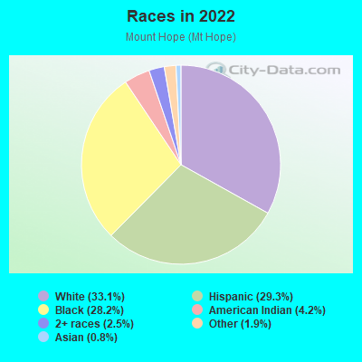
- 5,54733.1%White
- 4,90729.3%Hispanic or Latino
- 4,73528.2%Black
- 7074.2%American Indian
- 4122.5%Two or more races
- 3181.9%Some other race
- 1420.8%Asian
Median household income in 2022:
| Mount Hope (Mt Hope): | $101,421 |
| Massachusetts: | $94,488 |
Distribution of median household income
![Distribution of median household income]()
- 378Less than $10,000
- 372$10,000 to $19,999
- 466$20,000 to $29,999
- 643$30,000 to $39,999
- 142$40,000 to $49,999
- 296$50,000 to $59,999
- 688$60,000 to $74,999
- 1,091$75,000 to $99,999
- 444$100,000 to $124,999
- 289$125,000 to $149,999
- 467$150,000 to $199,999
- 1,295$200,000 or more

Distribution of owner-occupied house/condo value
![Distribution of owner-occupied house/condo value]()
- 296Less than $50,000
- 194$50,000 to $99,999
- 80$100,000 to $149,999
- 72$150,000 to $199,999
- 101$200,000 to $249,999
- 231$250,000 to $299,999
- 163$300,000 to $399,999
- 861$400,000 to $499,999
- 1,381$500,000 to $749,999
- 668$750,000 to $999,999
- 171$1,000,000 or more

Distribution of rent paid by renters
![Distribution of rent paid by renters]()
- 298Less than $100
- 224$100 to $199
- 346$200 to $299
- 166$300 to $399
- 359$400 to $499
- 1,623$500 to $599
- 488$600 to $699
- 102$800 to $899
- 266$900 to $999
- 794$1,000 to $1,249
- 1,028$1,250 to $1,499
- 753$1,500 to $1,999
- 741$2,000 or more

Median rent in 2022:
| Mount Hope (Mt Hope): | $1,592 |
| Massachusetts: | $1,446 |
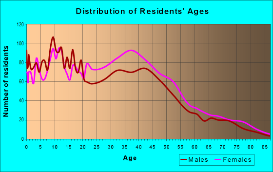
| Males: | 7,695 |
| Females: | 8,178 |
| Males: | 35.7 years |
| Females: | 38.3 years |
Average household size:
| Mount Hope (Mt Hope): | 2.5 people |
| Massachusetts: | 2.4 people |
Percentage of family households:
| Mount Hope (Mt Hope): | 54.4% |
| Massachusetts: | 43.1% |
| Here: | 37.1% |
| Massachusetts: | 45.2% |
Percentage of married-couple families with children (among all households):
| Mount Hope (Mt Hope): | 22.6% |
| Massachusetts: | 56.2% |
Percentage of single-mother households (among all households):
| Mount Hope (Mt Hope): | 10.4% |
| Massachusetts: | 8.7% |
Percentage of never married males 15 years old and over:
Percentage of never married females 15 years old and over:
| Mount Hope (Mt Hope): | 21.6% |
| Massachusetts: | 19.4% |
Percentage of never married females 15 years old and over:
| Mount Hope (Mt Hope): | 18.6% |
| Massachusetts: | 18.4% |
Percentage of people that speak English not well or not at all:
| Mount Hope (Mt Hope): | 11.2% |
| Massachusetts: | 5.2% |
Percentage of people born in this state:
Percentage of people born in another U.S. state:
Percentage of native residents but born outside the U.S.:
Percentage of foreign born residents:
| Here: | 52.2% |
| Massachusetts: | 58.6% |
Percentage of people born in another U.S. state:
| Mount Hope (Mt Hope): | 11.3% |
| Massachusetts: | 20.5% |
Percentage of native residents but born outside the U.S.:
| Here: | 5.2% |
| Massachusetts: | 2.8% |
Percentage of foreign born residents:
| Here: | 31.3% |
| Massachusetts: | 18.0% |
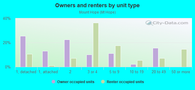
Owner-occupied
Renter-occupied

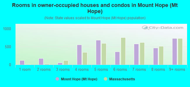
- Rooms in owner-occupied houses and condos in Mount Hope <
> - 1181 room
- 1772 rooms
- 593 rooms
- 5614 rooms
- 6855 rooms
- 3646 rooms
- 5847 rooms
- 4678 rooms
- 7359+ rooms
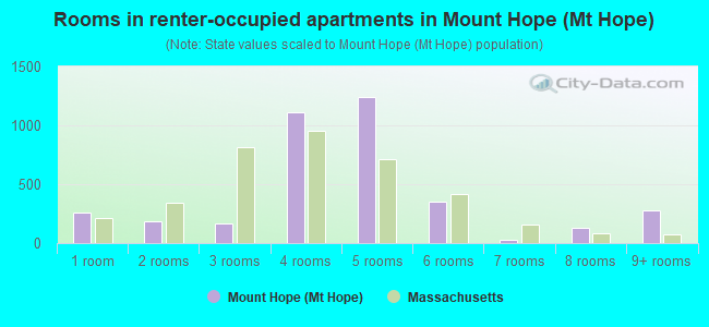
- Rooms in renter-occupied apartments in Mount Hope <
> - 2631 room
- 1812 rooms
- 1713 rooms
- 1,1144 rooms
- 1,2425 rooms
- 3566 rooms
- 297 rooms
- 1328 rooms
- 2799+ rooms
Owner-occupied
Renter-occupied
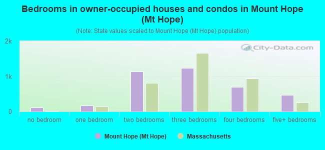
- Bedrooms in owner-occupied houses and condos in Mount Hope <
> - 118no bedroom
- 1641 bedroom
- 1,1292 bedrooms
- 1,2313 bedrooms
- 7024 bedrooms
- 4745+ bedrooms
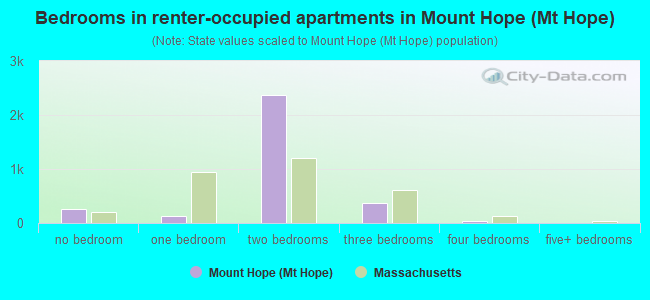
- Bedrooms in renter-occupied apartments in Mount Hope <
> - 263no bedroom
- 1311 bedroom
- 2,3622 bedrooms
- 3633 bedrooms
- 344 bedrooms
- 05+ bedrooms
Average number of cars or other vehicles available in houses/condos:
Average number of cars or other vehicles available in apartments:
| This neighborhood: | 1.4 |
| Massachusetts: | 2.0 |
Average number of cars or other vehicles available in apartments:
| Here: | 0.8 |
| Massachusetts: | 1.1 |
Percentage of units with a mortgage:
| Mount Hope (Mt Hope): | 86.5% |
| Massachusetts: | 65.5% |
Housing prices:
- Average estimated value of detached houses in 2022 (19.9% of all units):
Mount Hope (Mt Hope): $663,192 Massachusetts: $651,570
- Average estimated value of townhouses or other attached units in 2022 (8.5% of all units):
This neighborhood: $506,401 Massachusetts: $617,749
- Average estimated value of housing units in 2-unit structures in 2022 (18.8% of all units):
This neighborhood: $660,653 Massachusetts: $594,808
- Average estimated '22 value of housing units in 3-to-4-unit structures (33.8% of all units):
Mount Hope (Mt Hope): $584,295 Massachusetts: $601,912
- Average estimated '22 value of housing units in 5-or-more-unit structures (9.9% of all units):
Mount Hope (Mt Hope): $272,193 Massachusetts: $555,768
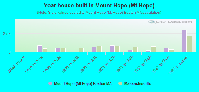
- Year house built in Mount Hope <
> - 762020 or later
- 8902010 to 2019
- 5592000 to 2009
- 901990 to 1999
- 6871980 to 1989
- 8951970 to 1979
- 3481960 to 1969
- 2451950 to 1959
- 5681940 to 1949
- 2,9821939 or earlier
Travel time to work (commute)
![Travel time to work (commute)]()
- 87Less than 5 minutes
- 715 to 9 minutes
- 17610 to 14 minutes
- 1,52115 to 19 minutes
- 62020 to 24 minutes
- 95525 to 29 minutes
- 1,85530 to 34 minutes
- 35635 to 39 minutes
- 49540 to 44 minutes
- 1,00045 to 59 minutes
- 82460 to 89 minutes
- 20490 or more minutes

Means of transportation to work
![Means of transportation to work]()
- 59.3%4,842Drove a car alone
- 4.3%349Carpooled
- 7.6%619Bus
- 14.0%1,143Subway or elevated rail
- 2.7%223Long-distance train or commuter rail
- 0.3%25Taxi
- 2.1%168Bicycle
- 2.1%168Walked
- 0.9%71Other means
- 7.6%619Worked at home

Time leaving home to go to work
![Time leaving home to go to work]()
- 17512:00 a.m. to 4:59 a.m.
- 3055:00 a.m. to 5:29 a.m.
- 4015:30 a.m. to 5:59 a.m.
- 1,2956:00 a.m. to 6:29 a.m.
- 4966:30 a.m. to 6:59 a.m.
- 1,0777:00 a.m. to 7:29 a.m.
- 1,2817:30 a.m. to 7:59 a.m.
- 7878:00 a.m. to 8:29 a.m.
- 3888:30 a.m. to 8:59 a.m.
- 9539:00 a.m. to 9:59 a.m.
- 25910:00 a.m. to 10:59 a.m.
- 21311:00 a.m. to 11:59 a.m.
- 45512:00 p.m. to 3:59 p.m.
- 764:00 p.m. to 11:59 p.m.

Occupations of males:
- Percentage of males in management occupations (except farmers):
Here: 4.8% Massachusetts: 14.0%
- Percentage of males in business and financial operations occupations:
Here: 7.4% Massachusetts: 6.5%
- Percentage of males in computer and mathematical occupations:
Here: 6.9% Massachusetts: 6.9%
- Percentage of males in architecture and engineering occupations:
Here: 5.9% Massachusetts: 4.2%
- Percentage of males in legal occupations:
Here: 3.3% Massachusetts: 1.5%
- Percentage of males in education, training, and library occupations:
Here: 4.3% Massachusetts: 4.3%
- Percentage of males in arts, design, entertainment, sports, and media occupations:
Here: 11.0% Massachusetts: 2.2%
- Percentage of males in healthcare practitioners and technical occupations:
Here: 5.6% Massachusetts: 3.2%
- Percentage of males in service occupations:
Here: 9.8% Massachusetts: 13.5%
- Percentage of males in sales and office occupations:
Here: 13.4% Massachusetts: 14.0%
- Percentage of males in construction, extraction, and maintenance occupations:
Here: 1.2% Massachusetts: 8.2%
- Percentage of males in production occupations:
Here: 4.5% Massachusetts: 5.1%
- Percentage of males in transportation occupations:
Here: 11.1% Massachusetts: 4.9%
- Percentage of males in material moving occupations:
Here: 1.5% Massachusetts: 3.5%
Occupations of females:
- Percentage of females in management occupations (except farmers):
Here: 5.1% Massachusetts: 11.3%
- Percentage of females in business and financial operations occupations:
Here: 11.2% Massachusetts: 7.6%
- Percentage of females in computer and mathematical occupations:
Here: 1.6% Massachusetts: 2.6%
- Percentage of females in community and social services occupations:
Here: 2.5% Massachusetts: 3.1%
- Percentage of females in legal occupations:
Here: 7.3% Massachusetts: 1.5%
- Percentage of females in education, training, and library occupations:
Here: 12.8% Massachusetts: 10.9%
- Percentage of females in arts, design, entertainment, sports, and media occupations:
Here: 1.4% Massachusetts: 2.6%
- Percentage of females in healthcare practitioners and technical occupations:
Here: 5.8% Massachusetts: 10.8%
- Percentage of females in service occupations:
Here: 38.6% Massachusetts: 18.3%
- Percentage of females in sales and office occupations:
Here: 10.7% Massachusetts: 22.6%
- Percentage of females in production occupations:
Here: 1.1% Massachusetts: 2.5%
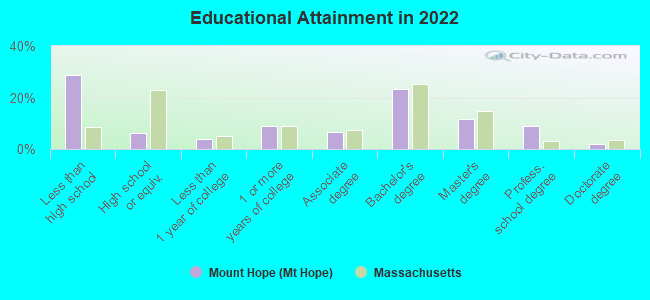
Education in this neighborhood (subdivision or community):
- Percentage of people 3 years and older in K-12 schools:
Mount Hope (Mt Hope): 21.9% Massachusetts: 14.7%
- Percentage of people 3 years and older in undergraduate colleges:
Mount Hope (Mt Hope): 6.1% Massachusetts: 5.9%
- Percentage of people 3 years and older in grad. or professional schools:
Mount Hope (Mt Hope): 3.0% Massachusetts: 2.2%
- Percentage of students K-12 enrolled in private schools:
Mount Hope (Mt Hope): 38.4% Massachusetts: 11.0%
Percentage of population below poverty level:
| Mount Hope (Mt Hope): | 12.7% |
| Massachusetts: | 10.4% |
Median year owner moved in (as recorded in 2022):
Median year renter moved in (as recorded in 2022):
| Mount Hope (Mt Hope): | 2009 |
| Massachusetts: | 2009 |
Median year renter moved in (as recorded in 2022):
| Mount Hope (Mt Hope): | 2014 |
| Massachusetts: | 2019 |
Percentage of married-couple families with both working:
| Mount Hope (Mt Hope): | 108.0% |
| Massachusetts: | 78.0% |
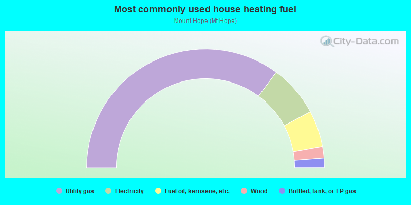
- 70.3%Utility gas
- 14.1%Electricity
- 9.9%Fuel oil, kerosene, etc.
- 3.2%Wood
- 2.5%Bottled, tank, or LP gas
Roads and streets:
Canterbury St
Length: 0.97 miles
Directions: E-W, N-S, SE-NW, SW-NE
Address range: 626 to 977
Directions: E-W, N-S, SE-NW, SW-NE
Address range: 626 to 977
American Legion Hwy
Length: 0.87 miles
Directions: N-S, SE-NW, SW-NE
Address range: 581 to 948
Directions: N-S, SE-NW, SW-NE
Address range: 581 to 948
Washington St
Length: 0.71 miles
Direction: SW-NE
Address range: 3937 to 4231
Direction: SW-NE
Address range: 3937 to 4231
Mount Hope St
Length: 0.67 miles
Directions: N-S, SE-NW
Address range: 1 to 194
Directions: N-S, SE-NW
Address range: 1 to 194
Cummins Hwy
Length: 0.58 miles
Directions: E-W, SE-NW
Address range: 24 to 473
Directions: E-W, SE-NW
Address range: 24 to 473
Florence St
Length: 0.56 miles
Directions: E-W, N-S, SE-NW, SW-NE
Address range: 51 to 299
Directions: E-W, N-S, SE-NW, SW-NE
Address range: 51 to 299
South St
Length: 0.54 miles
Directions: E-W, N-S, SE-NW, SW-NE
Address range: 561 to 768
Directions: E-W, N-S, SE-NW, SW-NE
Address range: 561 to 768
Harvard St
Length: 0.49 miles
Directions: E-W, N-S, SW-NE
Address range: 679 to 1099
Directions: E-W, N-S, SW-NE
Address range: 679 to 1099
Hyde Park Ave
Length: 0.44 miles
Direction: N-S
Address range: 462 to 636
Direction: N-S
Address range: 462 to 636
Johnswood Rd
Length: 0.32 miles
Directions: E-W, N-S, SE-NW, SW-NE
Address range: 1 to 99
Directions: E-W, N-S, SE-NW, SW-NE
Address range: 1 to 99
Fawndale Rd
Length: 0.29 miles
Directions: E-W, N-S, SE-NW, SW-NE
Address range: 1 to 170
Directions: E-W, N-S, SE-NW, SW-NE
Address range: 1 to 170
Brown Ave
Length: 0.29 miles
Directions: N-S, SW-NE
Address range: 52 to 209
Directions: N-S, SW-NE
Address range: 52 to 209
Rowe St
Length: 0.28 miles
Directions: N-S, SE-NW
Address range: 1 to 120
Directions: N-S, SE-NW
Address range: 1 to 120
Stella Rd
Length: 0.28 miles
Directions: E-W, SE-NW
Address range: 1 to 99
Directions: E-W, SE-NW
Address range: 1 to 99
Granfield Ave
Length: 0.23 miles
Directions: E-W, SE-NW
Address range: 1 to 99
Directions: E-W, SE-NW
Address range: 1 to 99
Stellman Rd
Length: 0.23 miles
Directions: E-W, SE-NW
Address range: 1 to 99
Directions: E-W, SE-NW
Address range: 1 to 99
Brookway Rd
Length: 0.22 miles
Directions: N-S, SE-NW, SW-NE
Address range: 18 to 132
Directions: N-S, SE-NW, SW-NE
Address range: 18 to 132
Mount Calvary Rd
Length: 0.22 miles
Directions: N-S, SW-NE
Address range: 1 to 27
Directions: N-S, SW-NE
Address range: 1 to 27
Prospect Ave
Length: 0.22 miles
Directions: E-W, SE-NW
Address range: 1 to 99
Directions: E-W, SE-NW
Address range: 1 to 99
Bradeen St
Length: 0.22 miles
Directions: E-W, SE-NW
Address range: 1 to 99
Directions: E-W, SE-NW
Address range: 1 to 99
Sherwood St
Length: 0.21 miles
Directions: E-W, SW-NE
Address range: 45 to 199
Directions: E-W, SW-NE
Address range: 45 to 199
Walk Hill St
Length: 0.20 miles
Direction: SE-NW
Address range: 372 to 426
Direction: SE-NW
Address range: 372 to 426
Sycamore St
Length: 0.20 miles
Direction: SW-NE
Address range: 141 to 199
Direction: SW-NE
Address range: 141 to 199
Harding Rd
Length: 0.20 miles
Directions: E-W, N-S, SE-NW, SW-NE
Address range: 1 to 70
Directions: E-W, N-S, SE-NW, SW-NE
Address range: 1 to 70
Firth Rd
Length: 0.20 miles
Direction: SE-NW
Address range: 1 to 99
Direction: SE-NW
Address range: 1 to 99
Bexley Rd
Length: 0.19 miles
Direction: SE-NW
Address range: 1 to 47
Direction: SE-NW
Address range: 1 to 47
Brookdale St
Length: 0.19 miles
Directions: E-W, SE-NW, SW-NE
Address range: 1 to 99
Directions: E-W, SE-NW, SW-NE
Address range: 1 to 99
Navarre St
Length: 0.19 miles
Directions: N-S, SE-NW
Address range: 1 to 81
Directions: N-S, SE-NW
Address range: 1 to 81
Ridge St
Length: 0.19 miles
Direction: SE-NW
Address range: 1 to 99
Direction: SE-NW
Address range: 1 to 99
Starbird Ave
Length: 0.19 miles
Direction: SW-NE
Address range: 1 to 99
Direction: SW-NE
Address range: 1 to 99
Murray Hill Rd
Length: 0.19 miles
Direction: SE-NW
Address range: 1 to 99
Direction: SE-NW
Address range: 1 to 99
Whipple Ave
Length: 0.15 miles
Directions: E-W, SE-NW
Address range: 1 to 49
Directions: E-W, SE-NW
Address range: 1 to 49
Bradstreet Ave
Length: 0.15 miles
Directions: N-S, SE-NW, SW-NE
Address range: 1 to 99
Directions: N-S, SE-NW, SW-NE
Address range: 1 to 99
Clare Ave
Length: 0.15 miles
Directions: N-S, SW-NE
Address range: 1 to 49
Directions: N-S, SW-NE
Address range: 1 to 49
Manning St
Length: 0.14 miles
Directions: E-W, SW-NE
Address range: 1 to 99
Directions: E-W, SW-NE
Address range: 1 to 99
Marion St
Length: 0.14 miles
Directions: SE-NW, SW-NE
Address range: 1 to 99
Directions: SE-NW, SW-NE
Address range: 1 to 99
Archdale Rd
Length: 0.14 miles
Direction: SE-NW
Address range: 23 to 199
Direction: SE-NW
Address range: 23 to 199
Lindall St
Length: 0.12 miles
Direction: SW-NE
Address range: 1 to 99
Direction: SW-NE
Address range: 1 to 99
Taft Hill Ter
Length: 0.12 miles
Direction: SW-NE
Address range: 1 to 99
Direction: SW-NE
Address range: 1 to 99
Basile St
Length: 0.12 miles
Direction: SE-NW
Address range: 1 to 99
Direction: SE-NW
Address range: 1 to 99
Legion Pl
Length: 0.12 miles
Direction: SE-NW
Address range: 1 to 99
Direction: SE-NW
Address range: 1 to 99
Destefano Rd
Length: 0.12 miles
Direction: SE-NW
Address range: 1 to 49
Direction: SE-NW
Address range: 1 to 49
Wilmot St
Length: 0.11 miles
Direction: E-W
Address range: 1 to 99
Direction: E-W
Address range: 1 to 99
Gilman St
Length: 0.10 miles
Direction: SE-NW
Address range: 1 to 99
Direction: SE-NW
Address range: 1 to 99
Ramsdell Ave
Length: 0.10 miles
Directions: E-W, SE-NW
Address range: 24 to 99
Directions: E-W, SE-NW
Address range: 24 to 99
Lesher St
Length: 0.09 miles
Direction: SE-NW
Address range: 1 to 99
Direction: SE-NW
Address range: 1 to 99
Brookway Ter
Length: 0.09 miles
Directions: N-S, SE-NW
Address range: 1 to 99
Directions: N-S, SE-NW
Address range: 1 to 99
Gardenside St
Length: 0.09 miles
Direction: SE-NW
Address range: 1 to 99
Direction: SE-NW
Address range: 1 to 99
Curley St
Length: 0.09 miles
Directions: N-S, SE-NW
Address range: 1 to 99
Directions: N-S, SE-NW
Address range: 1 to 99
Sammett Ave
Length: 0.09 miles
Direction: N-S
Address range: 2 to 99
Direction: N-S
Address range: 2 to 99
Allen St
Length: 0.09 miles
Direction: SE-NW
Address range: 2 to 105
Direction: SE-NW
Address range: 2 to 105
Harrison St
Length: 0.09 miles
Direction: SW-NE
Address range: 1 to 49
Direction: SW-NE
Address range: 1 to 49
Mosgrove Ave
Length: 0.09 miles
Direction: SE-NW
Address range: 1 to 99
Direction: SE-NW
Address range: 1 to 99
Elven Rd
Length: 0.08 miles
Direction: SE-NW
Address range: 1 to 99
Direction: SE-NW
Address range: 1 to 99
Hadwin Way
Length: 0.08 miles
Direction: E-W
Address range: 1 to 99
Direction: E-W
Address range: 1 to 99
Charme Ave
Length: 0.07 miles
Direction: N-S
Address range: 1 to 33
Direction: N-S
Address range: 1 to 33
Holly Rd
Length: 0.07 miles
Direction: SE-NW
Address range: 1 to 99
Direction: SE-NW
Address range: 1 to 99
Lee Hill Rd
Length: 0.07 miles
Direction: SE-NW
Address range: 1 to 99
Direction: SE-NW
Address range: 1 to 99
Claxton St
Length: 0.07 miles
Directions: E-W, SE-NW
Address range: 1 to 99
Directions: E-W, SE-NW
Address range: 1 to 99
Delford St
Length: 0.06 miles
Direction: SW-NE
Address range: 1 to 99
Direction: SW-NE
Address range: 1 to 99
Toppan Ave
Length: 0.06 miles
Direction: E-W
Direction: E-W
Jewett St
Length: 0.06 miles
Direction: SW-NE
Address range: 11 to 99
Direction: SW-NE
Address range: 11 to 99
Fowle St
Length: 0.06 miles
Direction: E-W
Address range: 1 to 99
Direction: E-W
Address range: 1 to 99
Paine St
Length: 0.05 miles
Directions: E-W, SW-NE
Address range: 61 to 99
Directions: E-W, SW-NE
Address range: 61 to 99
Palfrey St
Length: 0.05 miles
Direction: E-W
Address range: 10 to 98
Direction: E-W
Address range: 10 to 98
Blakemore St
Length: 0.04 miles
Direction: E-W
Address range: 2 to 99
Direction: E-W
Address range: 2 to 99
List Pl
Length: 0.02 miles
Direction: N-S
Address range: 1 to 99
Direction: N-S
Address range: 1 to 99
Railroad features:
Amtrak RR (Mbta Commuter Rail)
Length: 1.00 miles
Directions: N-S, SW-NE
Directions: N-S, SW-NE