Margaretta Township (Margaretta) neighborhood in Sandusky, Ohio (OH), 44824, 44870 detailed profile
Settings
X


Business Search - 14 Million verified businesses
Area: 51.183 square miles
Population: 10,219
Population density:
| Margaretta Township (Margaretta): | 200 people per square mile |
| Sandusky: | 2,484 people per square mile |

- 9,49068.0%White
- 3,47924.9%Black
- 3892.8%Asian
- 2752.0%Two or more races
- 1831.3%Some other race
- 970.7%Hispanic or Latino
- 390.3%American Indian
- 60.04%Native Hawaiian and Other
Pacific Islander

Median household income in 2022:
| Margaretta Township (Margaretta): | $76,350 |
| Sandusky: | $47,375 |
Distribution of median household income
![Distribution of median household income]()
- 257Less than $10,000
- 317$10,000 to $19,999
- 596$20,000 to $29,999
- 217$30,000 to $39,999
- 580$40,000 to $49,999
- 319$50,000 to $59,999
- 454$60,000 to $74,999
- 618$75,000 to $99,999
- 296$100,000 to $124,999
- 219$125,000 to $149,999
- 518$150,000 to $199,999
- 258$200,000 or more

Distribution of owner-occupied house/condo value
![Distribution of owner-occupied house/condo value]()
- 900Less than $50,000
- 1,250$50,000 to $99,999
- 767$100,000 to $149,999
- 929$150,000 to $199,999
- 320$200,000 to $249,999
- 516$250,000 to $299,999
- 212$300,000 to $399,999
- 37$400,000 to $499,999
- 72$500,000 to $749,999
- 9$750,000 to $999,999
- 9$1,000,000 or more

Distribution of rent paid by renters
![Distribution of rent paid by renters]()
- 10$100 to $199
- 8$200 to $299
- 501$300 to $399
- 63$400 to $499
- 50$500 to $599
- 1,863$600 to $699
- 258$700 to $799
- 248$800 to $899
- 1,127$900 to $999
- 60$1,000 to $1,249
- 14$1,500 to $1,999

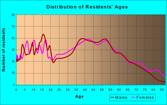
| Males: | 5,101 |
| Females: | 5,118 |
Males:
| This neighborhood: | 41.3 years |
| Whole city: | 36.3 years |
| This neighborhood: | 43.6 years |
| Whole city: | 39.3 years |
Average household size:
| Margaretta Township (Margaretta): | 5.1 people |
| Sandusky: | 2.2 people |
Percentage of family households:
| Margaretta Township (Margaretta): | 41.7% |
| Sandusky: | 44.7% |
| Here: | 48.6% |
| Sandusky: | 27.8% |
Percentage of married-couple families with children (among all households):
| Margaretta Township (Margaretta): | 31.5% |
| Sandusky: | 12.3% |
Percentage of single-mother households (among all households):
| Margaretta Township (Margaretta): | 10.6% |
| Sandusky: | 27.8% |
Percentage of never married males 15 years old and over:
Percentage of never married females 15 years old and over:
| Margaretta Township (Margaretta): | 17.0% |
| Sandusky: | 21.4% |
Percentage of never married females 15 years old and over:
| Margaretta Township (Margaretta): | 11.7% |
| city: | 22.8% |
Percentage of people that speak English not well or not at all:
| Margaretta Township (Margaretta): | 0.0% |
| Sandusky: | 0.6% |
Percentage of people born in this state:
Percentage of people born in another U.S. state:
Percentage of native residents but born outside the U.S.:
Percentage of foreign born residents:
| Here: | 82.7% |
| Sandusky: | 81.0% |
Percentage of people born in another U.S. state:
| Margaretta Township (Margaretta): | 16.5% |
| Sandusky: | 16.8% |
Percentage of native residents but born outside the U.S.:
| Here: | 0.7% |
| city: | 0.9% |
Percentage of foreign born residents:
| Here: | 0.6% |
| Sandusky: | 1.3% |

Owner-occupied
Renter-occupied


- Rooms in owner-occupied houses and condos in Margaretta Township <
> - 461 room
- 712 rooms
- 473 rooms
- 3304 rooms
- 5985 rooms
- 7556 rooms
- 6327 rooms
- 2918 rooms
- 6269+ rooms

- Rooms in renter-occupied apartments in Margaretta Township <
> - 01 room
- 1,2202 rooms
- 23 rooms
- 7634 rooms
- 2675 rooms
- 1886 rooms
- 3527 rooms
- 1448 rooms
- 169+ rooms
Owner-occupied
Renter-occupied

- Bedrooms in owner-occupied houses and condos in Margaretta Township <
> - 46no bedroom
- 201 bedroom
- 6682 bedrooms
- 1,7663 bedrooms
- 5424 bedrooms
- 2285+ bedrooms

- Bedrooms in renter-occupied apartments in Margaretta Township <
> - 0no bedroom
- 2391 bedroom
- 1,4862 bedrooms
- 2113 bedrooms
- 3154 bedrooms
- 145+ bedrooms
Average number of cars or other vehicles available in houses/condos:
Average number of cars or other vehicles available in apartments:
| This neighborhood: | 2.0 |
| Sandusky: | 1.8 |
Average number of cars or other vehicles available in apartments:
| Here: | |
| city: |
Percentage of units with a mortgage:
| Margaretta Township (Margaretta): | 61.7% |
| Sandusky: | 58.4% |
Average estimated value of detached houses in 2022 (68.9% of all units):
| Margaretta Township (Margaretta): | $179,020 |
| Sandusky: | $137,106 |

- Year house built in Margaretta Township <
> - 02020 or later
- 1412010 to 2019
- 2,9102000 to 2009
- 1631990 to 1999
- 2,0291980 to 1989
- 6851970 to 1979
- 5581960 to 1969
- 8151950 to 1959
- 2881940 to 1949
- 6911939 or earlier

City-data.com crime index for city in 2020 (higher means more crime):
| City: | 198.9 |
| U.S. average: | 219.5 |
Travel time to work (commute)
![Travel time to work (commute)]()
- 367Less than 5 minutes
- 1,6995 to 9 minutes
- 99010 to 14 minutes
- 92115 to 19 minutes
- 45720 to 24 minutes
- 12125 to 29 minutes
- 46930 to 34 minutes
- 6535 to 39 minutes
- 6740 to 44 minutes
- 17545 to 59 minutes
- 8760 to 89 minutes
- 17890 or more minutes

Means of transportation to work
![Means of transportation to work]()
- 92.1%3,994Drove a car alone
- 3.5%151Carpooled
- 8.5%368Bus
- 1.4%62Motorcycle
- 0.2%7Bicycle
- 1.0%43Walked
- 1.4%59Other means
- 2.3%101Worked at home

Time leaving home to go to work
![Time leaving home to go to work]()
- 46712:00 a.m. to 4:59 a.m.
- 1335:00 a.m. to 5:29 a.m.
- 2015:30 a.m. to 5:59 a.m.
- 3476:00 a.m. to 6:29 a.m.
- 6066:30 a.m. to 6:59 a.m.
- 6857:00 a.m. to 7:29 a.m.
- 8447:30 a.m. to 7:59 a.m.
- 5778:00 a.m. to 8:29 a.m.
- 2698:30 a.m. to 8:59 a.m.
- 1969:00 a.m. to 9:59 a.m.
- 8410:00 a.m. to 10:59 a.m.
- 2011:00 a.m. to 11:59 a.m.
- 59512:00 p.m. to 3:59 p.m.
- 3774:00 p.m. to 11:59 p.m.

Occupations of males:
- Percentage of males in management occupations (except farmers):
Here: 21.7% city: 8.6%
- Percentage of males in business and financial operations occupations:
Here: 1.5% city: 3.9%
- Percentage of males in computer and mathematical occupations:
Here: 5.7% city: 2.0%
- Percentage of males in architecture and engineering occupations:
Here: 4.9% city: 1.0%
- Percentage of males in education, training, and library occupations:
Here: 3.4% city: 3.0%
- Percentage of males in arts, design, entertainment, sports, and media occupations:
Here: 1.4% city: 2.4%
- Percentage of males in service occupations:
Here: 13.6% city: 13.6%
- Percentage of males in sales and office occupations:
Here: 14.9% city: 15.6%
- Percentage of males in construction, extraction, and maintenance occupations:
Here: 7.9% city: 6.2%
- Percentage of males in production occupations:
Here: 7.2% city: 16.9%
- Percentage of males in transportation occupations:
Here: 2.3% city: 5.2%
- Percentage of males in material moving occupations:
Here: 4.6% city: 12.8%
Occupations of females:
- Percentage of females in management occupations (except farmers):
Here: 4.8% city: 5.7%
- Percentage of females in business and financial operations occupations:
Here: 9.5% city: 2.7%
- Percentage of females in community and social services occupations:
Here: 2.7% city: 1.8%
- Percentage of females in legal occupations:
Here: 1.4% city: 0.1%
- Percentage of females in education, training, and library occupations:
Here: 7.6% city: 7.8%
- Percentage of females in arts, design, entertainment, sports, and media occupations:
Here: 1.2% city: 0.0%
- Percentage of females in healthcare practitioners and technical occupations:
Here: 15.4% city: 7.8%
- Percentage of females in service occupations:
Here: 27.1% city: 31.0%
- Percentage of females in sales and office occupations:
Here: 24.0% city: 25.8%
- Percentage of females in production occupations:
Here: 5.5% city: 12.1%
Percentage of people 16-64 in Armed Forces:
| Margaretta Township (Margaretta): | 0.2% |
| Sandusky: | 0.0% |
Education in this neighborhood (subdivision or community):
- Percentage of people 3 years and older in K-12 schools:
Margaretta Township (Margaretta): 18.6% Sandusky: 15.0%
- Percentage of people 3 years and older in undergraduate colleges:
Margaretta Township (Margaretta): 11.1% Sandusky: 2.5%
- Percentage of people 3 years and older in grad. or professional schools:
Margaretta Township (Margaretta): 5.6% Sandusky: 1.2%
- Percentage of students K-12 enrolled in private schools:
Margaretta Township (Margaretta): 105.6% Sandusky: 15.8%
Percentage of population below poverty level:
| Margaretta Township (Margaretta): | 5.5% |
| Sandusky: | 20.5% |
Median year owner moved in (as recorded in 2022):
| Margaretta Township (Margaretta): | 2006 |
| Sandusky: | 2005 |
Percentage of married-couple families with both working:
| Margaretta Township (Margaretta): | 85.1% |
| Sandusky: | 90.6% |

- 36.0%Utility gas
- 27.7%Electricity
- 23.1%Bottled, tank, or LP gas
- 4.9%Wood
- 4.1%Other fuel
- 2.4%No fuel used
- 1.9%Fuel oil, kerosene, etc.
Highways in this neighborhood:
State Rte 269 (State Rte 2)
Length: 17.68 miles
Directions: E-W, N-S, SE-NW
Directions: E-W, N-S, SE-NW
Lima Sandusky Rd (US Rte 6, US Hwy 6)
Length: 4.67 miles
Directions: E-W, SW-NE
Address range: 1200 to 4999
Directions: E-W, SW-NE
Address range: 1200 to 4999
State Rte 4 (Hayes Ave, Wright Brothers Memorial Hwy)
Length: 3.05 miles
Directions: N-S, SW-NE
Address range: 4500 to 7601
Directions: N-S, SW-NE
Address range: 4500 to 7601
Tiffin Ave (State Rte 101)
Length: 2.90 miles
Directions: E-W, SW-NE
Address range: 3720 to 6299
Directions: E-W, SW-NE
Address range: 3720 to 6299
State Rte 269 (State Rte 269 S)
Length: 2.58 miles
Directions: N-S, SW-NE
Address range: 600 to 6023
Directions: N-S, SW-NE
Address range: 600 to 6023
Sandusky-Clyde Rd (State Rte 101, State Rte 101 W)
Length: 2.54 miles
Directions: E-W, N-S, SW-NE
Address range: 8000 to 10075
Directions: E-W, N-S, SW-NE
Address range: 8000 to 10075
State Rte 269 (Prairie Rd)
Length: 2.21 miles
Directions: N-S, SE-NW
Address range: 900 to 1699
Directions: N-S, SE-NW
Address range: 900 to 1699
Bailey St (Martin Point Rd, State Rte 269)
Length: 1.95 miles
Direction: N-S
Address range: 1000 to 2398
Direction: N-S
Address range: 1000 to 2398
US Rte 6 (US Hwy 6, Fremont Ave)
Length: 1.24 miles
Directions: E-W, SW-NE
Address range: 200 to 1199
Directions: E-W, SW-NE
Address range: 200 to 1199
State Rte 101 (State Rte 101 W, W Lucas St)
Length: 0.69 miles
Direction: E-W
Address range: 100 to 7999
Direction: E-W
Address range: 100 to 7999
N Washington St (State Rte 269)
Length: 0.62 miles
Directions: N-S, SE-NW
Address range: 100 to 699
Directions: N-S, SE-NW
Address range: 100 to 699
S Washington St (State Rte 269)
Length: 0.45 miles
Directions: N-S, SE-NW
Address range: 100 to 616
Directions: N-S, SE-NW
Address range: 100 to 616
State Rte 101 (Depot St)
Length: 0.39 miles
Direction: E-W
Address range: 200 to 235
Direction: E-W
Address range: 200 to 235
Roads and streets:
Maple Ave
Length: 6.76 miles
Directions: E-W, N-S, SE-NW, SW-NE
Address range: 700 to 5999
Directions: E-W, N-S, SE-NW, SW-NE
Address range: 700 to 5999
Heywood Rd
Length: 5.55 miles
Directions: E-W, SE-NW, SW-NE
Address range: 1101 to 7199
Directions: E-W, SE-NW, SW-NE
Address range: 1101 to 7199
Wahl Rd
Length: 5.29 miles
Directions: E-W, N-S, SE-NW, SW-NE
Address range: 4000 to 7899
Directions: E-W, N-S, SE-NW, SW-NE
Address range: 4000 to 7899
Bardshar Rd
Length: 5.09 miles
Directions: N-S, SE-NW
Address range: 400 to 5617
Directions: N-S, SE-NW
Address range: 400 to 5617
Co Hwy 13 (Mason Rd)
Length: 3.91 miles
Direction: E-W
Address range: 7706 to 11799
Direction: E-W
Address range: 7706 to 11799
Barrett Rd
Length: 3.27 miles
Directions: E-W, SE-NW
Address range: 5500 to 8199
Directions: E-W, SE-NW
Address range: 5500 to 8199
Miller Rd
Length: 3.22 miles
Directions: E-W, N-S, SE-NW
Address range: 2500 to 5799
Directions: E-W, N-S, SE-NW
Address range: 2500 to 5799
Bogart Rd W
Length: 3.19 miles
Direction: E-W
Address range: 3560 to 6499
Direction: E-W
Address range: 3560 to 6499
Homegardner Rd
Length: 2.74 miles
Directions: E-W, SE-NW, SW-NE
Address range: 4774 to 7022
Directions: E-W, SE-NW, SW-NE
Address range: 4774 to 7022
Old Railroad Rd
Length: 2.48 miles
Direction: SW-NE
Address range: 4156 to 6599
Direction: SW-NE
Address range: 4156 to 6599
Twp Hwy 27 (Parker Rd)
Length: 2.39 miles
Direction: E-W
Address range: 6000 to 7899
Direction: E-W
Address range: 6000 to 7899
McCartney Rd
Length: 2.24 miles
Directions: E-W, SE-NW, SW-NE
Address range: 5100 to 6614
Directions: E-W, SE-NW, SW-NE
Address range: 5100 to 6614
Oxbo Rd
Length: 1.60 miles
Direction: E-W
Address range: 8600 to 9099
Direction: E-W
Address range: 8600 to 9099
Thicket Rd
Length: 1.43 miles
Direction: E-W
Address range: 6600 to 7599
Direction: E-W
Address range: 6600 to 7599
Lake St (Billings Rd)
Length: 1.29 miles
Direction: N-S
Address range: 4100 to 5265
Direction: N-S
Address range: 4100 to 5265
Co Rd 10 (W Bogart Rd)
Length: 1.22 miles
Direction: E-W
Address range: 2877 to 3899
Direction: E-W
Address range: 2877 to 3899
Bardwell Rd
Length: 1.14 miles
Directions: E-W, SE-NW
Address range: 300 to 6299
Directions: E-W, SE-NW
Address range: 300 to 6299
Co Hwy 42 (Skadden Rd)
Length: 1.12 miles
Direction: SE-NW
Address range: 5340 to 6267
Direction: SE-NW
Address range: 5340 to 6267
Billings Rd (Twp Hwy 38)
Length: 0.91 miles
Direction: N-S
Address range: 5266 to 5914
Direction: N-S
Address range: 5266 to 5914
Main St
Length: 0.90 miles
Directions: E-W, SW-NE
Address range: 100 to 714
Directions: E-W, SW-NE
Address range: 100 to 714
E Lucas St
Length: 0.89 miles
Directions: E-W, SW-NE
Address range: 100 to 599
Directions: E-W, SW-NE
Address range: 100 to 599
Twp Hwy 102 (Deyo Rd)
Length: 0.86 miles
Direction: N-S
Address range: 5901 to 6265
Direction: N-S
Address range: 5901 to 6265
Rogers Rd (Twp Hwy 28)
Length: 0.83 miles
Direction: E-W
Address range: 6800 to 8143
Direction: E-W
Address range: 6800 to 8143
Crystal Rock Ave
Length: 0.79 miles
Directions: N-S, SE-NW
Address range: 100 to 799
Directions: N-S, SE-NW
Address range: 100 to 799
Sunset Plz
Length: 0.72 miles
Directions: E-W, N-S, SE-NW
Address range: 1000 to 1899
Directions: E-W, N-S, SE-NW
Address range: 1000 to 1899
E Bayview Dr
Length: 0.70 miles
Directions: E-W, SE-NW
Address range: 201 to 1499
Directions: E-W, SE-NW
Address range: 201 to 1499
S Wood Trl
Length: 0.63 miles
Directions: E-W, N-S, SE-NW
Directions: E-W, N-S, SE-NW
Venice Rd (Barrett Rd)
Length: 0.59 miles
Direction: SE-NW
Address range: 4800 to 5499
Direction: SE-NW
Address range: 4800 to 5499
W Bayview Dr
Length: 0.59 miles
Directions: E-W, N-S, SE-NW, SW-NE
Address range: 106 to 199
Directions: E-W, N-S, SE-NW, SW-NE
Address range: 106 to 199
Newberry Ave
Length: 0.55 miles
Directions: N-S, SE-NW, SW-NE
Address range: 100 to 299
Directions: N-S, SE-NW, SW-NE
Address range: 100 to 299
Ridgewood Dr
Length: 0.53 miles
Direction: E-W
Address range: 6500 to 6899
Direction: E-W
Address range: 6500 to 6899
Grand Pass
Length: 0.52 miles
Direction: SE-NW
Address range: 100 to 1199
Direction: SE-NW
Address range: 100 to 1199
Cement St
Length: 0.50 miles
Directions: E-W, SW-NE
Address range: 200 to 407
Directions: E-W, SW-NE
Address range: 200 to 407
Northwest Rd
Length: 0.50 miles
Direction: N-S
Direction: N-S
Herr Rd
Length: 0.50 miles
Directions: E-W, N-S, SE-NW, SW-NE
Address range: 8700 to 8822
Directions: E-W, N-S, SE-NW, SW-NE
Address range: 8700 to 8822
Alspaugh Dr
Length: 0.48 miles
Direction: E-W
Address range: 6500 to 6730
Direction: E-W
Address range: 6500 to 6730
Bayshore Rd
Length: 0.47 miles
Directions: E-W, SW-NE
Address range: 4300 to 4999
Directions: E-W, SW-NE
Address range: 4300 to 4999
Brunner Rd
Length: 0.47 miles
Direction: N-S
Direction: N-S
Adams Ave (Adams St)
Length: 0.46 miles
Directions: E-W, N-S, SW-NE
Address range: 100 to 338
Directions: E-W, N-S, SW-NE
Address range: 100 to 338
Susan Dr
Length: 0.44 miles
Directions: E-W, N-S, SE-NW
Address range: 5601 to 6899
Directions: E-W, N-S, SE-NW
Address range: 5601 to 6899
W Cherokee Trl
Length: 0.43 miles
Directions: E-W, SW-NE
Address range: 1 to 299
Directions: E-W, SW-NE
Address range: 1 to 299
Lester St
Length: 0.41 miles
Directions: E-W, SW-NE
Address range: 100 to 345
Directions: E-W, SW-NE
Address range: 100 to 345
W Cayuga Trl
Length: 0.38 miles
Directions: E-W, N-S, SW-NE
Address range: 100 to 299
Directions: E-W, N-S, SW-NE
Address range: 100 to 299
Rockwood Dr
Length: 0.38 miles
Directions: E-W, SE-NW
Address range: 5100 to 5399
Directions: E-W, SE-NW
Address range: 5100 to 5399
Wilson Ave
Length: 0.37 miles
Direction: N-S
Address range: 1 to 1200
Direction: N-S
Address range: 1 to 1200
Muirwood Dr
Length: 0.37 miles
Directions: E-W, N-S, SE-NW, SW-NE
Directions: E-W, N-S, SE-NW, SW-NE
Willow Point Rd
Length: 0.36 miles
Directions: N-S, SE-NW
Directions: N-S, SE-NW
Laurel Dr
Length: 0.36 miles
Directions: E-W, N-S, SW-NE
Address range: 5600 to 5898
Directions: E-W, N-S, SW-NE
Address range: 5600 to 5898
Fishing Pier
Length: 0.32 miles
Direction: N-S
Direction: N-S
Delores Dr
Length: 0.30 miles
Direction: E-W
Address range: 5600 to 5726
Direction: E-W
Address range: 5600 to 5726
Debra Dr
Length: 0.30 miles
Direction: E-W
Address range: 5600 to 5721
Direction: E-W
Address range: 5600 to 5721
Maple Hills Dr
Length: 0.30 miles
Direction: E-W
Address range: 6000 to 6211
Direction: E-W
Address range: 6000 to 6211
Howard Dr
Length: 0.29 miles
Directions: N-S, SE-NW
Directions: N-S, SE-NW
Pfeil Ln
Length: 0.29 miles
Directions: E-W, N-S, SW-NE
Directions: E-W, N-S, SW-NE
Providence Dr
Length: 0.28 miles
Directions: E-W, SE-NW
Address range: 4901 to 5100
Directions: E-W, SE-NW
Address range: 4901 to 5100
E Oneida Trl
Length: 0.28 miles
Direction: SW-NE
Address range: 100 to 199
Direction: SW-NE
Address range: 100 to 199
Comanche Trl
Length: 0.28 miles
Direction: N-S
Address range: 2100 to 2198
Direction: N-S
Address range: 2100 to 2198
E Cherokee Trl
Length: 0.27 miles
Direction: SW-NE
Address range: 101 to 149
Direction: SW-NE
Address range: 101 to 149
Barden St
Length: 0.27 miles
Direction: SE-NW
Address range: 100 to 299
Direction: SE-NW
Address range: 100 to 299
W Mohegan Trl
Length: 0.27 miles
Direction: E-W
Address range: 100 to 140
Direction: E-W
Address range: 100 to 140
E Mohegan Trl
Length: 0.26 miles
Direction: SW-NE
Address range: 100 to 146
Direction: SW-NE
Address range: 100 to 146
Lowell St
Length: 0.26 miles
Direction: SE-NW
Address range: 100 to 299
Direction: SE-NW
Address range: 100 to 299
E Cayuga Trl
Length: 0.26 miles
Direction: SW-NE
Address range: 100 to 147
Direction: SW-NE
Address range: 100 to 147
Bellevue Ave
Length: 0.25 miles
Directions: N-S, SE-NW
Address range: 100 to 437
Directions: N-S, SE-NW
Address range: 100 to 437
W Iroquois Trl
Length: 0.25 miles
Direction: E-W
Address range: 100 to 137
Direction: E-W
Address range: 100 to 137
Park View Trl
Length: 0.24 miles
Direction: E-W
Direction: E-W
E Iroquois Trl
Length: 0.24 miles
Direction: SW-NE
Address range: 100 to 144
Direction: SW-NE
Address range: 100 to 144
E Seminole Trl
Length: 0.24 miles
Direction: SW-NE
Address range: 101 to 147
Direction: SW-NE
Address range: 101 to 147
W Tuscarawas Trl
Length: 0.23 miles
Direction: E-W
Address range: 100 to 142
Direction: E-W
Address range: 100 to 142
E Tuscarawas Trl
Length: 0.23 miles
Direction: SW-NE
Address range: 100 to 199
Direction: SW-NE
Address range: 100 to 199
Woodland Trl
Length: 0.21 miles
Directions: E-W, SW-NE
Address range: 1 to 199
Directions: E-W, SW-NE
Address range: 1 to 199
E Algonquin Trl
Length: 0.21 miles
Direction: SW-NE
Address range: 100 to 138
Direction: SW-NE
Address range: 100 to 138
Edgewater Trailer Park
Length: 0.21 miles
Directions: E-W, N-S, SW-NE
Directions: E-W, N-S, SW-NE
W Algonquin Trl
Length: 0.21 miles
Direction: E-W
Address range: 100 to 133
Direction: E-W
Address range: 100 to 133
Norwood Ave
Length: 0.21 miles
Directions: N-S, SW-NE
Address range: 100 to 299
Directions: N-S, SW-NE
Address range: 100 to 299
Castalia Ave
Length: 0.21 miles
Directions: E-W, N-S, SE-NW, SW-NE
Address range: 100 to 299
Directions: E-W, N-S, SE-NW, SW-NE
Address range: 100 to 299
Chickasaw Trl
Length: 0.20 miles
Direction: N-S
Address range: 2100 to 2148
Direction: N-S
Address range: 2100 to 2148
E Ogontz Trl
Length: 0.20 miles
Direction: SW-NE
Address range: 100 to 137
Direction: SW-NE
Address range: 100 to 137
Gary Dr
Length: 0.20 miles
Direction: N-S
Address range: 3700 to 3728
Direction: N-S
Address range: 3700 to 3728
Fairview Ave
Length: 0.20 miles
Direction: N-S
Address range: 100 to 299
Direction: N-S
Address range: 100 to 299
Jefferson St
Length: 0.20 miles
Direction: E-W
Address range: 100 to 214
Direction: E-W
Address range: 100 to 214
Spring St
Length: 0.20 miles
Directions: E-W, SE-NW
Address range: 113 to 220
Directions: E-W, SE-NW
Address range: 113 to 220
Ronald Dr
Length: 0.20 miles
Direction: N-S
Address range: 3700 to 5604
Direction: N-S
Address range: 3700 to 5604
Harrison Ct
Length: 0.20 miles
Direction: N-S
Direction: N-S
Strouse Ln
Length: 0.19 miles
Directions: E-W, SW-NE
Address range: 6281 to 6290
Directions: E-W, SW-NE
Address range: 6281 to 6290
W Ogontz Trl
Length: 0.19 miles
Direction: E-W
Address range: 100 to 128
Direction: E-W
Address range: 100 to 128
Church St
Length: 0.19 miles
Directions: N-S, SW-NE
Address range: 101 to 223
Directions: N-S, SW-NE
Address range: 101 to 223
E Miami Trl
Length: 0.19 miles
Direction: SW-NE
Address range: 100 to 132
Direction: SW-NE
Address range: 100 to 132
Westwood Dr
Length: 0.19 miles
Directions: E-W, N-S, SE-NW
Address range: 1100 to 1439
Directions: E-W, N-S, SE-NW
Address range: 1100 to 1439
E Menominee Trl
Length: 0.18 miles
Direction: SW-NE
Address range: 100 to 199
Direction: SW-NE
Address range: 100 to 199
Briarcrest Dr
Length: 0.18 miles
Direction: N-S
Address range: 3500 to 3620
Direction: N-S
Address range: 3500 to 3620
W Miami Trl
Length: 0.17 miles
Direction: E-W
Address range: 100 to 124
Direction: E-W
Address range: 100 to 124
Wagner Ave
Length: 0.17 miles
Directions: N-S, SE-NW, SW-NE
Address range: 100 to 112
Directions: N-S, SE-NW, SW-NE
Address range: 100 to 112
Linwood Ave
Length: 0.17 miles
Direction: N-S
Address range: 100 to 299
Direction: N-S
Address range: 100 to 299
E Shawnee Trl
Length: 0.17 miles
Direction: SW-NE
Address range: 100 to 126
Direction: SW-NE
Address range: 100 to 126
Maple Rd (Teal Trl)
Length: 0.17 miles
Direction: N-S
Address range: 1 to 1299
Direction: N-S
Address range: 1 to 1299
Market St
Length: 0.17 miles
Direction: N-S
Address range: 300 to 415
Direction: N-S
Address range: 300 to 415
Sandusky Ave
Length: 0.16 miles
Direction: N-S
Address range: 100 to 299
Direction: N-S
Address range: 100 to 299
Columbus Crystal Rock Ave
Length: 0.16 miles
Direction: N-S
Address range: 100 to 299
Direction: N-S
Address range: 100 to 299
W Menominee Trl
Length: 0.16 miles
Direction: E-W
Address range: 100 to 116
Direction: E-W
Address range: 100 to 116
Martin Ave
Length: 0.16 miles
Direction: N-S
Address range: 100 to 299
Direction: N-S
Address range: 100 to 299
Rainbow Ave
Length: 0.15 miles
Directions: E-W, N-S, SW-NE
Address range: 1100 to 1299
Directions: E-W, N-S, SW-NE
Address range: 1100 to 1299
Winkel Ct
Length: 0.15 miles
Direction: E-W
Direction: E-W
South Ave
Length: 0.15 miles
Direction: E-W
Direction: E-W
E Seneca Trl
Length: 0.15 miles
Direction: SW-NE
Address range: 100 to 124
Direction: SW-NE
Address range: 100 to 124
Potawatomi Trl
Length: 0.15 miles
Direction: N-S
Direction: N-S
Reed Ct
Length: 0.14 miles
Directions: E-W, SE-NW
Address range: 100 to 199
Directions: E-W, SE-NW
Address range: 100 to 199
Sunset Ave
Length: 0.14 miles
Directions: E-W, N-S, SE-NW, SW-NE
Address range: 1100 to 1299
Directions: E-W, N-S, SE-NW, SW-NE
Address range: 1100 to 1299
W Shawnee Trl
Length: 0.14 miles
Direction: E-W
Address range: 100 to 121
Direction: E-W
Address range: 100 to 121
S 101 (Tiffin Ave, S 101, State Rte 101)
Length: 0.14 miles
Direction: SW-NE
Direction: SW-NE
Harding Ave (Harding Rd)
Length: 0.14 miles
Direction: N-S
Address range: 1 to 1299
Direction: N-S
Address range: 1 to 1299
Bayshore Ct
Length: 0.14 miles
Directions: E-W, N-S, SE-NW, SW-NE
Address range: 4400 to 4499
Directions: E-W, N-S, SE-NW, SW-NE
Address range: 4400 to 4499
W Seneca Trl
Length: 0.13 miles
Direction: E-W
Address range: 100 to 119
Direction: E-W
Address range: 100 to 119
Landsrush St
Length: 0.13 miles
Direction: E-W
Address range: 100 to 699
Direction: E-W
Address range: 100 to 699
Clyde Ave
Length: 0.13 miles
Direction: N-S
Address range: 200 to 299
Direction: N-S
Address range: 200 to 299
Niagara St
Length: 0.13 miles
Directions: E-W, SW-NE
Address range: 100 to 210
Directions: E-W, SW-NE
Address range: 100 to 210
Langston Pl
Length: 0.13 miles
Directions: E-W, N-S, SE-NW, SW-NE
Address range: 101 to 698
Directions: E-W, N-S, SE-NW, SW-NE
Address range: 101 to 698
Hillcrest Dr
Length: 0.12 miles
Directions: N-S, SW-NE
Address range: 5200 to 5312
Directions: N-S, SW-NE
Address range: 5200 to 5312
W Delaware Trl
Length: 0.11 miles
Direction: E-W
Address range: 100 to 116
Direction: E-W
Address range: 100 to 116
Walnut St
Length: 0.11 miles
Direction: N-S
Address range: 212 to 315
Direction: N-S
Address range: 212 to 315
E Delaware Trl
Length: 0.11 miles
Direction: SW-NE
Direction: SW-NE
Swan St
Length: 0.11 miles
Directions: N-S, SE-NW
Address range: 300 to 314
Directions: N-S, SE-NW
Address range: 300 to 314
Portland Ave
Length: 0.11 miles
Directions: E-W, SW-NE
Address range: 100 to 298
Directions: E-W, SW-NE
Address range: 100 to 298
Willow Ave
Length: 0.11 miles
Directions: N-S, SW-NE
Directions: N-S, SW-NE
McCreery Ct
Length: 0.10 miles
Directions: E-W, SE-NW
Directions: E-W, SE-NW
Greenfield Ave
Length: 0.10 miles
Directions: E-W, SW-NE
Address range: 7500 to 7527
Directions: E-W, SW-NE
Address range: 7500 to 7527
Marigold Dr
Length: 0.09 miles
Direction: N-S
Address range: 5300 to 5314
Direction: N-S
Address range: 5300 to 5314
S Water
Length: 0.09 miles
Direction: N-S
Address range: 139 to 210
Direction: N-S
Address range: 139 to 210
Ward St
Length: 0.09 miles
Directions: E-W, SE-NW
Address range: 4800 to 4908
Directions: E-W, SE-NW
Address range: 4800 to 4908
Pleasant Ln
Length: 0.09 miles
Direction: SW-NE
Address range: 1100 to 1199
Direction: SW-NE
Address range: 1100 to 1199
Oak St
Length: 0.08 miles
Direction: N-S
Address range: 300 to 319
Direction: N-S
Address range: 300 to 319
Sandusky
Length: 0.07 miles
Directions: E-W, SE-NW
Address range: 201 to 207
Directions: E-W, SE-NW
Address range: 201 to 207
Brailey St
Length: 0.07 miles
Direction: E-W
Address range: 100 to 110
Direction: E-W
Address range: 100 to 110
Burton St
Length: 0.07 miles
Direction: SW-NE
Direction: SW-NE
East Dr
Length: 0.06 miles
Directions: N-S, SW-NE
Address range: 300 to 399
Directions: N-S, SW-NE
Address range: 300 to 399
Windswood Way
Length: 0.06 miles
Directions: N-S, SE-NW
Address range: 101 to 998
Directions: N-S, SE-NW
Address range: 101 to 998
N Water St
Length: 0.06 miles
Direction: N-S
Address range: 101 to 113
Direction: N-S
Address range: 101 to 113
Oak Ln
Length: 0.06 miles
Directions: E-W, SW-NE
Directions: E-W, SW-NE
Inland Ave
Length: 0.06 miles
Directions: E-W, SE-NW
Address range: 438 to 499
Directions: E-W, SE-NW
Address range: 438 to 499
Carson Pass
Length: 0.06 miles
Direction: E-W
Direction: E-W
Custer Pass
Length: 0.06 miles
Direction: E-W
Direction: E-W
Mohawk Path
Length: 0.06 miles
Direction: SE-NW
Direction: SE-NW
Cody Pass
Length: 0.06 miles
Direction: E-W
Direction: E-W
Sunnydale Dr
Length: 0.06 miles
Direction: E-W
Direction: E-W
Pemington Pl
Length: 0.05 miles
Direction: E-W
Address range: 101 to 398
Direction: E-W
Address range: 101 to 398
Eastwood Dr
Length: 0.05 miles
Direction: N-S
Address range: 1500 to 1599
Direction: N-S
Address range: 1500 to 1599
South Pass
Length: 0.05 miles
Directions: N-S, SE-NW
Address range: 1500 to 1599
Directions: N-S, SE-NW
Address range: 1500 to 1599
Willow Glen Dr
Length: 0.04 miles
Direction: N-S
Address range: 3400 to 3422
Direction: N-S
Address range: 3400 to 3422
Mitchell St
Length: 0.03 miles
Direction: N-S
Direction: N-S
Center Dr
Length: 0.03 miles
Direction: N-S
Address range: 200 to 299
Direction: N-S
Address range: 200 to 299
Sheffield Way
Length: 0.03 miles
Direction: SW-NE
Address range: 101 to 498
Direction: SW-NE
Address range: 101 to 498
West Dr
Length: 0.03 miles
Direction: N-S
Address range: 100 to 199
Direction: N-S
Address range: 100 to 199
Choctaw Path
Length: 0.02 miles
Direction: N-S
Direction: N-S
Railroad features:
Conrail RR
Length: 3.89 miles
Direction: SE-NW
Direction: SE-NW
Norfolk and Western Rlwy
Length: 3.34 miles
Directions: N-S, SW-NE
Directions: N-S, SW-NE
Other features:
Mills Crk
Length: 5.26 miles
Directions: E-W, N-S, SE-NW, SW-NE
Directions: E-W, N-S, SE-NW, SW-NE
Liles Ditch
Length: 2.63 miles
Directions: E-W, N-S, SE-NW, SW-NE
Directions: E-W, N-S, SE-NW, SW-NE
Little Pickerel Crk
Length: 0.82 miles
Directions: E-W, SW-NE
Directions: E-W, SW-NE
Cold Crk
Length: 0.67 miles
Directions: N-S, SW-NE
Directions: N-S, SW-NE
Gypsum Road
Length: 0.43 miles
Directions: E-W, N-S, SE-NW, SW-NE
Directions: E-W, N-S, SE-NW, SW-NE
Dahs Ditch
Length: 0.42 miles
Directions: N-S, SE-NW
Directions: N-S, SE-NW
Roads and streets:
Bay Blvd (Co Rd 283)
Length: 0.14 miles
Directions: E-W, SW-NE
Address range: 5940 to 5999
Directions: E-W, SW-NE
Address range: 5940 to 5999
Glad Ave (Co Rd 281)
Length: 0.12 miles
Direction: E-W
Address range: 5900 to 5999
Direction: E-W
Address range: 5900 to 5999
Co Rd 285 (Willow Rd)
Length: 0.08 miles
Direction: SW-NE
Address range: 6000 to 6029
Direction: SW-NE
Address range: 6000 to 6029
Co Rd 333
Length: 0.07 miles
Direction: E-W
Direction: E-W
Tolliver Pl (Co Rd 338)
Length: 0.05 miles
Direction: SE-NW
Address range: 3000 to 3099
Direction: SE-NW
Address range: 3000 to 3099
Paseka Pl (Co Rd 334)
Length: 0.05 miles
Direction: SE-NW
Address range: 3000 to 3099
Direction: SE-NW
Address range: 3000 to 3099
Co Rd 336 (Barr Pl)
Length: 0.04 miles
Direction: SE-NW
Address range: 3000 to 3099
Direction: SE-NW
Address range: 3000 to 3099
Hill Pl (Co Rd 340)
Length: 0.04 miles
Direction: N-S
Address range: 3070 to 3099
Direction: N-S
Address range: 3070 to 3099
Hill Rd (Co Rd 290)
Length: 0.04 miles
Direction: N-S
Address range: 3080 to 3099
Direction: N-S
Address range: 3080 to 3099
Custer Ps (Co Rd 312, Northwest Rd)
Length: 0.01 miles
Direction: N-S
Direction: N-S