Laurence Harbor (Laurence Harbor CDP) neighborhood in South Amboy, New Jersey (NJ), 07735, 08879 detailed profile
Settings
X


Business Search - 14 Million verified businesses
Area: 2.904 square miles
Population: 8,282
Population density:
| Laurence Harbor (Laurence Harbor CDP): | 2,852 people per square mile |
| South Amboy: | 6,020 people per square mile |

- 4,54552.7%White
- 1,44716.8%Hispanic or Latino
- 88410.3%Black
- 8039.3%Two or more races
- 7168.3%Asian
- 2232.6%Some other race

Median household income in 2022:
| Laurence Harbor (Laurence Harbor CDP): | $96,292 |
| South Amboy: | $94,776 |
Distribution of median household income
![Distribution of median household income]()
- 104Less than $10,000
- 442$10,000 to $19,999
- 338$20,000 to $29,999
- 567$30,000 to $39,999
- 178$40,000 to $49,999
- 803$50,000 to $59,999
- 625$60,000 to $74,999
- 616$75,000 to $99,999
- 517$100,000 to $124,999
- 373$125,000 to $149,999
- 332$150,000 to $199,999
- 396$200,000 or more

Distribution of owner-occupied house/condo value
![Distribution of owner-occupied house/condo value]()
- 61Less than $50,000
- 170$50,000 to $99,999
- 109$100,000 to $149,999
- 599$150,000 to $199,999
- 506$200,000 to $249,999
- 1,071$250,000 to $299,999
- 764$300,000 to $399,999
- 754$400,000 to $499,999
- 218$500,000 to $749,999
- 82$750,000 to $999,999
- 209$1,000,000 or more

Distribution of rent paid by renters
![Distribution of rent paid by renters]()
- 26Less than $100
- 93$500 to $599
- 43$600 to $699
- 41$700 to $799
- 17$800 to $899
- 43$900 to $999
- 341$1,000 to $1,249
- 453$1,250 to $1,499
- 320$1,500 to $1,999
- 762$2,000 or more

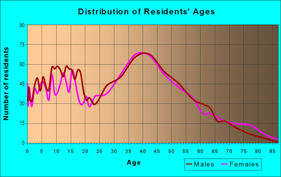
| Males: | 3,894 |
| Females: | 4,388 |
Males:
| This neighborhood: | 40.3 years |
| Whole city: | 40.8 years |
| This neighborhood: | 43.7 years |
| Whole city: | 41.1 years |
Average household size:
| Laurence Harbor (Laurence Harbor CDP): | 2.4 people |
| South Amboy: | 2.3 people |
Percentage of family households:
| Laurence Harbor (Laurence Harbor CDP): | 49.5% |
| South Amboy: | 53.0% |
| Here: | 45.7% |
| South Amboy: | 48.3% |
Percentage of married-couple families with children (among all households):
| Laurence Harbor (Laurence Harbor CDP): | 32.5% |
| South Amboy: | 25.9% |
Percentage of single-mother households (among all households):
| Laurence Harbor (Laurence Harbor CDP): | 24.4% |
| South Amboy: | 17.2% |
Percentage of never married males 15 years old and over:
Percentage of never married females 15 years old and over:
| Laurence Harbor (Laurence Harbor CDP): | 15.3% |
| South Amboy: | 15.9% |
Percentage of never married females 15 years old and over:
| Laurence Harbor (Laurence Harbor CDP): | 12.7% |
| city: | 15.1% |
Percentage of people that speak English not well or not at all:
| Laurence Harbor (Laurence Harbor CDP): | 1.4% |
| South Amboy: | 5.3% |
Percentage of people born in this state:
Percentage of people born in another U.S. state:
Percentage of native residents but born outside the U.S.:
Percentage of foreign born residents:
| Here: | 64.5% |
| South Amboy: | 62.4% |
Percentage of people born in another U.S. state:
| Laurence Harbor (Laurence Harbor CDP): | 15.4% |
| South Amboy: | 16.1% |
Percentage of native residents but born outside the U.S.:
| Here: | 4.0% |
| city: | 2.8% |
Percentage of foreign born residents:
| Here: | 16.0% |
| South Amboy: | 18.7% |
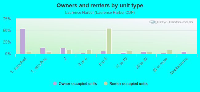
Owner-occupied
Renter-occupied

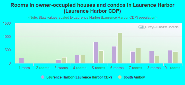
- Rooms in owner-occupied houses and condos in Laurence Harbor <
> - 2061 room
- 02 rooms
- 1373 rooms
- 3124 rooms
- 8105 rooms
- 6416 rooms
- 4437 rooms
- 4638 rooms
- 4859+ rooms
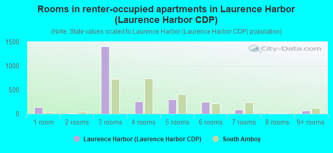
- Rooms in renter-occupied apartments in Laurence Harbor <
> - 1421 room
- 122 rooms
- 1,4013 rooms
- 2514 rooms
- 3025 rooms
- 2506 rooms
- 847 rooms
- 138 rooms
- 699+ rooms
Owner-occupied
Renter-occupied
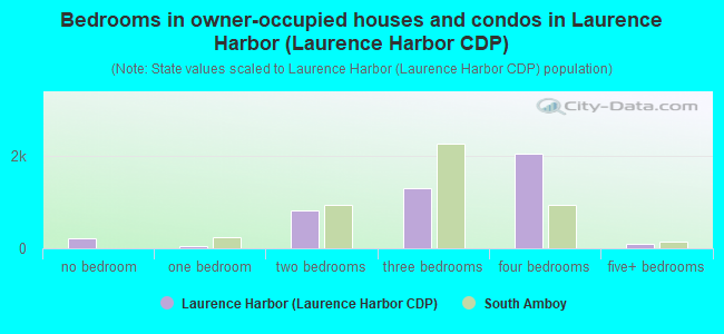
- Bedrooms in owner-occupied houses and condos in Laurence Harbor <
> - 206no bedroom
- 511 bedroom
- 8242 bedrooms
- 1,2973 bedrooms
- 2,0614 bedrooms
- 955+ bedrooms
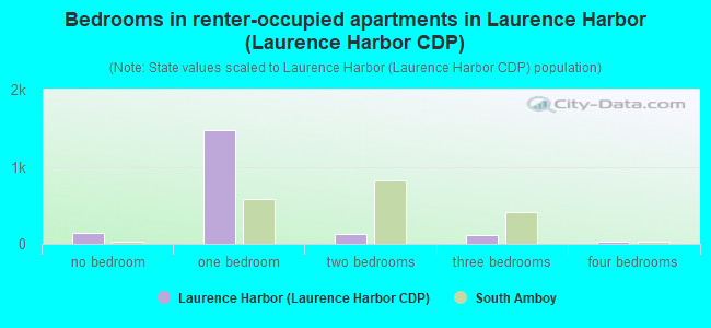
- Bedrooms in renter-occupied apartments in Laurence Harbor <
> - 144no bedroom
- 1,4701 bedroom
- 1222 bedrooms
- 1203 bedrooms
- 234 bedrooms
- 05+ bedrooms
Average number of cars or other vehicles available in houses/condos:
Average number of cars or other vehicles available in apartments:
| This neighborhood: | 2.3 |
| South Amboy: | 2.0 |
Average number of cars or other vehicles available in apartments:
| Here: | |
| city: |
Percentage of units with a mortgage:
| Laurence Harbor (Laurence Harbor CDP): | 76.2% |
| South Amboy: | 61.8% |
Average estimated value of detached houses in 2022 (70.4% of all units):
| Laurence Harbor (Laurence Harbor CDP): | $271,203 |
| South Amboy: | $362,730 |

- Year house built in Laurence Harbor <
> - 1192020 or later
- 3882010 to 2019
- 8982000 to 2009
- 1,2621990 to 1999
- 2921980 to 1989
- 2801970 to 1979
- 4511960 to 1969
- 6441950 to 1959
- 1711940 to 1949
- 7041939 or earlier
City-data.com crime index for city in 2020 (higher means more crime):
| City: | 80.9 |
| U.S. average: | 219.5 |
Travel time to work (commute)
![Travel time to work (commute)]()
- 41Less than 5 minutes
- 605 to 9 minutes
- 22610 to 14 minutes
- 23515 to 19 minutes
- 46120 to 24 minutes
- 18425 to 29 minutes
- 33430 to 34 minutes
- 3835 to 39 minutes
- 18040 to 44 minutes
- 30845 to 59 minutes
- 42760 to 89 minutes
- 22390 or more minutes

Means of transportation to work
![Means of transportation to work]()
- 68.6%2,811Drove a car alone
- 14.6%599Carpooled
- 2.2%89Bus
- 1.1%45Subway or elevated rail
- 3.1%125Long-distance train or commuter rail
- 20.3%833Ferryboat
- 3.2%130Taxi
- 0.4%16Bicycle
- 1.4%56Walked
- 20.9%858Other means
- 11.5%473Worked at home

Time leaving home to go to work
![Time leaving home to go to work]()
- 4812:00 a.m. to 4:59 a.m.
- 1245:00 a.m. to 5:29 a.m.
- 925:30 a.m. to 5:59 a.m.
- 2586:00 a.m. to 6:29 a.m.
- 2516:30 a.m. to 6:59 a.m.
- 3287:00 a.m. to 7:29 a.m.
- 3967:30 a.m. to 7:59 a.m.
- 3178:00 a.m. to 8:29 a.m.
- 1978:30 a.m. to 8:59 a.m.
- 1099:00 a.m. to 9:59 a.m.
- 1710:00 a.m. to 10:59 a.m.
- 14111:00 a.m. to 11:59 a.m.
- 27512:00 p.m. to 3:59 p.m.
- 954:00 p.m. to 11:59 p.m.

Occupations of males:
- Percentage of males in management occupations (except farmers):
Here: 6.1% city: 6.6%
- Percentage of males in business and financial operations occupations:
Here: 6.3% city: 2.8%
- Percentage of males in computer and mathematical occupations:
Here: 2.2% city: 4.5%
- Percentage of males in education, training, and library occupations:
Here: 8.4% city: 2.3%
- Percentage of males in healthcare practitioners and technical occupations:
Here: 3.2% city: 2.6%
- Percentage of males in service occupations:
Here: 22.6% city: 6.9%
- Percentage of males in sales and office occupations:
Here: 15.9% city: 18.7%
- Percentage of males in construction, extraction, and maintenance occupations:
Here: 3.9% city: 6.6%
- Percentage of males in production occupations:
Here: 4.9% city: 5.7%
- Percentage of males in transportation occupations:
Here: 6.6% city: 18.2%
- Percentage of males in material moving occupations:
Here: 8.2% city: 6.2%
Occupations of females:
- Percentage of females in management occupations (except farmers):
Here: 8.6% city: 10.8%
- Percentage of females in business and financial operations occupations:
Here: 10.0% city: 6.5%
- Percentage of females in computer and mathematical occupations:
Here: 2.4% city: 2.2%
- Percentage of females in community and social services occupations:
Here: 3.6% city: 1.8%
- Percentage of females in education, training, and library occupations:
Here: 5.5% city: 7.8%
- Percentage of females in healthcare practitioners and technical occupations:
Here: 12.3% city: 11.0%
- Percentage of females in service occupations:
Here: 22.3% city: 12.1%
- Percentage of females in sales and office occupations:
Here: 29.0% city: 34.7%
- Percentage of females in production occupations:
Here: 1.5% city: 1.4%
- Percentage of females in transportation occupations:
Here: 1.3% city: 0.5%
- Percentage of females in material moving occupations:
Here: 2.6% city: 0.7%
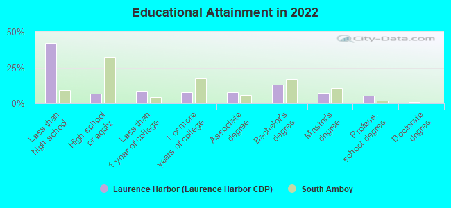
Education in this neighborhood (subdivision or community):
- Percentage of people 3 years and older in K-12 schools:
Laurence Harbor (Laurence Harbor CDP): 34.6% South Amboy: 11.8%
- Percentage of people 3 years and older in undergraduate colleges:
Laurence Harbor (Laurence Harbor CDP): 8.5% South Amboy: 5.0%
- Percentage of people 3 years and older in grad. or professional schools:
Laurence Harbor (Laurence Harbor CDP): 6.6% South Amboy: 0.3%
- Percentage of students K-12 enrolled in private schools:
Laurence Harbor (Laurence Harbor CDP): 139.7% South Amboy: 8.4%
Percentage of population below poverty level:
| Laurence Harbor (Laurence Harbor CDP): | 4.9% |
| South Amboy: | 7.3% |
Median year owner moved in (as recorded in 2022):
| Laurence Harbor (Laurence Harbor CDP): | 2007 |
| South Amboy: | 2005 |
Percentage of married-couple families with both working:
| Laurence Harbor (Laurence Harbor CDP): | 70.6% |
| South Amboy: | 54.2% |
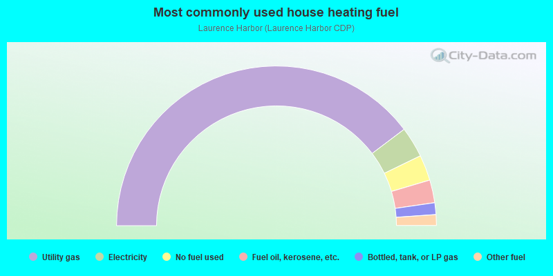
- 79.5%Utility gas
- 6.2%Electricity
- 5.2%No fuel used
- 4.6%Fuel oil, kerosene, etc.
- 2.4%Bottled, tank, or LP gas
- 2.2%Other fuel
Highways in this neighborhood:
State Rte 35
Length: 2.27 miles
Direction: SE-NW
Address range: 1 to 7099
Direction: SE-NW
Address range: 1 to 7099
Roads and streets:
Cheesequake Park Rd
Length: 1.58 miles
Directions: E-W, N-S, SE-NW, SW-NE
Directions: E-W, N-S, SE-NW, SW-NE
Laurence Pkwy (Co Rd 689)
Length: 0.99 miles
Directions: N-S, SE-NW, SW-NE
Address range: 20 to 732
Directions: N-S, SE-NW, SW-NE
Address range: 20 to 732
Ocean Blvd
Length: 0.96 miles
Directions: E-W, N-S, SE-NW, SW-NE
Address range: 1 to 452
Directions: E-W, N-S, SE-NW, SW-NE
Address range: 1 to 452
Shoreland Cir
Length: 0.93 miles
Directions: E-W, N-S, SE-NW, SW-NE
Address range: 1 to 389
Directions: E-W, N-S, SE-NW, SW-NE
Address range: 1 to 389
Matawan Rd (Co Rd 689)
Length: 0.88 miles
Directions: N-S, SW-NE
Address range: 1 to 978
Directions: N-S, SW-NE
Address range: 1 to 978
Raritan Blvd
Length: 0.87 miles
Directions: E-W, N-S, SE-NW, SW-NE
Address range: 1 to 501
Directions: E-W, N-S, SE-NW, SW-NE
Address range: 1 to 501
Greenwood Ave
Length: 0.67 miles
Directions: E-W, SW-NE
Address range: 154 to 807
Directions: E-W, SW-NE
Address range: 154 to 807
Alexandria Pkwy
Length: 0.52 miles
Directions: E-W, N-S, SE-NW, SW-NE
Directions: E-W, N-S, SE-NW, SW-NE
Forest Ave
Length: 0.51 miles
Direction: SW-NE
Address range: 613 to 899
Direction: SW-NE
Address range: 613 to 899
Boulevard E
Length: 0.49 miles
Directions: E-W, N-S, SE-NW, SW-NE
Address range: 1 to 99
Directions: E-W, N-S, SE-NW, SW-NE
Address range: 1 to 99
Furman Blvd
Length: 0.49 miles
Direction: SW-NE
Address range: 75 to 323
Direction: SW-NE
Address range: 75 to 323
Prospect Ave
Length: 0.49 miles
Direction: SW-NE
Address range: 256 to 768
Direction: SW-NE
Address range: 256 to 768
Harding Rd
Length: 0.48 miles
Directions: E-W, N-S, SE-NW, SW-NE
Address range: 2 to 599
Directions: E-W, N-S, SE-NW, SW-NE
Address range: 2 to 599
Bayview Dr
Length: 0.45 miles
Direction: E-W
Address range: 1 to 499
Direction: E-W
Address range: 1 to 499
Woodland Ave
Length: 0.44 miles
Direction: SE-NW
Address range: 644 to 682
Direction: SE-NW
Address range: 644 to 682
Charles St
Length: 0.44 miles
Directions: E-W, SE-NW
Directions: E-W, SE-NW
Summerfield Ave
Length: 0.41 miles
Direction: SE-NW
Address range: 2 to 903
Direction: SE-NW
Address range: 2 to 903
Palmer Ave
Length: 0.41 miles
Direction: E-W
Address range: 500 to 599
Direction: E-W
Address range: 500 to 599
Industrial Dr
Length: 0.41 miles
Direction: SW-NE
Address range: 3 to 99
Direction: SW-NE
Address range: 3 to 99
Valley Ave
Length: 0.40 miles
Directions: E-W, N-S, SE-NW
Address range: 1 to 599
Directions: E-W, N-S, SE-NW
Address range: 1 to 599
Boulevard W
Length: 0.40 miles
Directions: E-W, SE-NW, SW-NE
Address range: 53 to 116
Directions: E-W, SE-NW, SW-NE
Address range: 53 to 116
Arthur Ave
Length: 0.40 miles
Directions: E-W, N-S, SE-NW
Directions: E-W, N-S, SE-NW
Lucerne Dr
Length: 0.38 miles
Directions: E-W, SE-NW, SW-NE
Directions: E-W, SE-NW, SW-NE
Brookside Ave
Length: 0.38 miles
Direction: SW-NE
Address range: 201 to 497
Direction: SW-NE
Address range: 201 to 497
Biondi Ave (Biondi St)
Length: 0.35 miles
Directions: N-S, SW-NE
Address range: 20 to 85
Directions: N-S, SW-NE
Address range: 20 to 85
Groben Ave (Groben St)
Length: 0.35 miles
Directions: E-W, SE-NW
Address range: 615 to 641
Directions: E-W, SE-NW
Address range: 615 to 641
Cook Ave
Length: 0.34 miles
Directions: E-W, SE-NW, SW-NE
Address range: 645 to 1130
Directions: E-W, SE-NW, SW-NE
Address range: 645 to 1130
Pacific Blvd
Length: 0.33 miles
Direction: SW-NE
Address range: 1 to 116
Direction: SW-NE
Address range: 1 to 116
Britton Ave
Length: 0.33 miles
Direction: E-W
Address range: 200 to 299
Direction: E-W
Address range: 200 to 299
State Park Rd
Length: 0.33 miles
Directions: E-W, N-S, SE-NW, SW-NE
Directions: E-W, N-S, SE-NW, SW-NE
Pomona Blvd
Length: 0.33 miles
Directions: E-W, SW-NE
Address range: 12 to 88
Directions: E-W, SW-NE
Address range: 12 to 88
Holly Trl
Length: 0.32 miles
Directions: E-W, SW-NE
Directions: E-W, SW-NE
Capica Ct
Length: 0.32 miles
Directions: SE-NW, SW-NE
Address range: 1 to 47
Directions: SE-NW, SW-NE
Address range: 1 to 47
Orchard Ave
Length: 0.32 miles
Directions: E-W, SW-NE
Address range: 100 to 398
Directions: E-W, SW-NE
Address range: 100 to 398
Hilltop Ave
Length: 0.32 miles
Directions: E-W, SE-NW
Address range: 700 to 799
Directions: E-W, SE-NW
Address range: 700 to 799
Rosewood Dr
Length: 0.32 miles
Directions: E-W, SW-NE
Address range: 60 to 152
Directions: E-W, SW-NE
Address range: 60 to 152
Woodshore W
Length: 0.31 miles
Directions: E-W, SE-NW, SW-NE
Address range: 2 to 99
Directions: E-W, SE-NW, SW-NE
Address range: 2 to 99
Hilltop Blvd
Length: 0.31 miles
Directions: E-W, SW-NE
Address range: 131 to 189
Directions: E-W, SW-NE
Address range: 131 to 189
Woodshore E
Length: 0.30 miles
Directions: N-S, SE-NW, SW-NE
Address range: 1 to 48
Directions: N-S, SE-NW, SW-NE
Address range: 1 to 48
Birchwood Dr
Length: 0.28 miles
Directions: E-W, N-S, SW-NE
Address range: 1 to 298
Directions: E-W, N-S, SW-NE
Address range: 1 to 298
Linden Ter
Length: 0.28 miles
Directions: E-W, N-S, SE-NW
Directions: E-W, N-S, SE-NW
Norwood Ave
Length: 0.27 miles
Directions: E-W, N-S
Address range: 102 to 398
Directions: E-W, N-S
Address range: 102 to 398
Miller Ave
Length: 0.27 miles
Directions: E-W, SW-NE
Address range: 326 to 1106
Directions: E-W, SW-NE
Address range: 326 to 1106
Morningside Ave
Length: 0.24 miles
Directions: E-W, N-S, SW-NE
Address range: 2 to 199
Directions: E-W, N-S, SW-NE
Address range: 2 to 199
Rozalyn Ln
Length: 0.23 miles
Directions: E-W, N-S
Address range: 1 to 56
Directions: E-W, N-S
Address range: 1 to 56
Oakdale Ave
Length: 0.21 miles
Direction: SW-NE
Direction: SW-NE
Roosevelt Ave
Length: 0.21 miles
Directions: E-W, N-S, SE-NW
Address range: 87 to 199
Directions: E-W, N-S, SE-NW
Address range: 87 to 199
Charles St (Braney St)
Length: 0.21 miles
Directions: N-S, SW-NE
Address range: 326 to 445
Directions: N-S, SW-NE
Address range: 326 to 445
Grove Ave
Length: 0.20 miles
Direction: SW-NE
Address range: 616 to 963
Direction: SW-NE
Address range: 616 to 963
Hillcrest Ave
Length: 0.20 miles
Directions: E-W, N-S, SE-NW, SW-NE
Address range: 100 to 228
Directions: E-W, N-S, SE-NW, SW-NE
Address range: 100 to 228
Catherine Ct
Length: 0.20 miles
Directions: E-W, N-S, SE-NW
Address range: 1 to 51
Directions: E-W, N-S, SE-NW
Address range: 1 to 51
Gordon St
Length: 0.20 miles
Direction: SE-NW
Address range: 2 to 8
Direction: SE-NW
Address range: 2 to 8
Lake Ave
Length: 0.19 miles
Directions: E-W, N-S, SE-NW
Address range: 1 to 99
Directions: E-W, N-S, SE-NW
Address range: 1 to 99
Pine Island Ter
Length: 0.18 miles
Directions: E-W, SE-NW
Address range: 132 to 150
Directions: E-W, SE-NW
Address range: 132 to 150
Bridge Pointe Dr
Length: 0.18 miles
Direction: N-S
Address range: 1 to 15
Direction: N-S
Address range: 1 to 15
Lantana Way
Length: 0.18 miles
Directions: N-S, SE-NW
Address range: 24 to 105
Directions: N-S, SE-NW
Address range: 24 to 105
Maurer Ave
Length: 0.18 miles
Directions: E-W, SE-NW, SW-NE
Address range: 400 to 824
Directions: E-W, SE-NW, SW-NE
Address range: 400 to 824
Cleveland Ave
Length: 0.17 miles
Direction: SW-NE
Address range: 197 to 299
Direction: SW-NE
Address range: 197 to 299
Ely Ave
Length: 0.17 miles
Direction: E-W
Address range: 3 to 1148
Direction: E-W
Address range: 3 to 1148
McKinley Ave
Length: 0.17 miles
Directions: N-S, SW-NE
Address range: 100 to 199
Directions: N-S, SW-NE
Address range: 100 to 199
Lea Ave
Length: 0.17 miles
Direction: E-W
Address range: 328 to 443
Direction: E-W
Address range: 328 to 443
Sunset Blvd
Length: 0.17 miles
Directions: SE-NW, SW-NE
Address range: 300 to 312
Directions: SE-NW, SW-NE
Address range: 300 to 312
Columbus Ave
Length: 0.17 miles
Directions: N-S, SW-NE
Address range: 1 to 99
Directions: N-S, SW-NE
Address range: 1 to 99
Chimney Ct
Length: 0.16 miles
Directions: E-W, N-S
Address range: 1 to 36
Directions: E-W, N-S
Address range: 1 to 36
Linbrook Dr
Length: 0.16 miles
Direction: SE-NW
Address range: 1 to 100
Direction: SE-NW
Address range: 1 to 100
Outlook Blvd
Length: 0.16 miles
Directions: E-W, SW-NE
Address range: 217 to 282
Directions: E-W, SW-NE
Address range: 217 to 282
Boulevard S
Length: 0.16 miles
Directions: E-W, SE-NW
Address range: 1 to 99
Directions: E-W, SE-NW
Address range: 1 to 99
Evergreen Pl
Length: 0.16 miles
Direction: SW-NE
Direction: SW-NE
Central Ave
Length: 0.15 miles
Direction: SE-NW
Address range: 100 to 148
Direction: SE-NW
Address range: 100 to 148
Naples Ave
Length: 0.15 miles
Direction: SW-NE
Address range: 3 to 99
Direction: SW-NE
Address range: 3 to 99
Oliver Ave
Length: 0.14 miles
Direction: E-W
Address range: 1 to 199
Direction: E-W
Address range: 1 to 199
Alpine Way
Length: 0.14 miles
Directions: N-S, SE-NW
Address range: 231 to 299
Directions: N-S, SE-NW
Address range: 231 to 299
Garfield Ave
Length: 0.14 miles
Direction: N-S
Address range: 200 to 299
Direction: N-S
Address range: 200 to 299
Woodbine Way
Length: 0.13 miles
Directions: E-W, SE-NW
Address range: 242 to 352
Directions: E-W, SE-NW
Address range: 242 to 352
Meeker Ave
Length: 0.13 miles
Directions: E-W, N-S, SE-NW
Address range: 1 to 70
Directions: E-W, N-S, SE-NW
Address range: 1 to 70
Sunset Ave
Length: 0.13 miles
Directions: E-W, SW-NE
Address range: 2 to 107
Directions: E-W, SW-NE
Address range: 2 to 107
Arbutus Way
Length: 0.13 miles
Direction: SE-NW
Address range: 1000 to 1099
Direction: SE-NW
Address range: 1000 to 1099
Middlesex Blvd (Middlesex Ave)
Length: 0.13 miles
Direction: SE-NW
Address range: 1 to 22
Direction: SE-NW
Address range: 1 to 22
Savoy Ave
Length: 0.12 miles
Direction: SW-NE
Address range: 3 to 42
Direction: SW-NE
Address range: 3 to 42
Henry Pl
Length: 0.12 miles
Direction: SE-NW
Direction: SE-NW
Lincoln Ave
Length: 0.12 miles
Direction: N-S
Address range: 200 to 399
Direction: N-S
Address range: 200 to 399
Strachan St
Length: 0.11 miles
Directions: N-S, SE-NW
Address range: 100 to 120
Directions: N-S, SE-NW
Address range: 100 to 120
Monroe Ave
Length: 0.10 miles
Direction: N-S
Address range: 300 to 399
Direction: N-S
Address range: 300 to 399
Madison Ave
Length: 0.10 miles
Direction: N-S
Address range: 361 to 405
Direction: N-S
Address range: 361 to 405
Twilight Ave
Length: 0.09 miles
Direction: SW-NE
Address range: 100 to 161
Direction: SW-NE
Address range: 100 to 161
Ocean Ave
Length: 0.09 miles
Direction: SW-NE
Address range: 100 to 298
Direction: SW-NE
Address range: 100 to 298
Harbor Way
Length: 0.09 miles
Direction: SW-NE
Address range: 73 to 144
Direction: SW-NE
Address range: 73 to 144
Seaview Ave
Length: 0.09 miles
Direction: SW-NE
Address range: 219 to 299
Direction: SW-NE
Address range: 219 to 299
Shadyside Ave
Length: 0.09 miles
Direction: N-S
Address range: 2 to 99
Direction: N-S
Address range: 2 to 99
Cliffwood Way
Length: 0.08 miles
Direction: SW-NE
Address range: 1 to 50
Direction: SW-NE
Address range: 1 to 50
Ravine Ave
Length: 0.08 miles
Direction: E-W
Direction: E-W
Bayshore Ave
Length: 0.08 miles
Direction: SE-NW
Address range: 2 to 41
Direction: SE-NW
Address range: 2 to 41
Rowan Way
Length: 0.08 miles
Directions: N-S, SE-NW, SW-NE
Address range: 1 to 11
Directions: N-S, SE-NW, SW-NE
Address range: 1 to 11
E Beachwood Ave
Length: 0.08 miles
Direction: SW-NE
Address range: 201 to 298
Direction: SW-NE
Address range: 201 to 298
Daleron Pl
Length: 0.07 miles
Directions: N-S, SE-NW, SW-NE
Address range: 1 to 22
Directions: N-S, SE-NW, SW-NE
Address range: 1 to 22
Raymond Pl
Length: 0.07 miles
Directions: E-W, N-S, SE-NW, SW-NE
Address range: 1100 to 1162
Directions: E-W, N-S, SE-NW, SW-NE
Address range: 1100 to 1162
Lakeview Rd
Length: 0.07 miles
Direction: SW-NE
Address range: 39 to 98
Direction: SW-NE
Address range: 39 to 98
Wilson Ave
Length: 0.07 miles
Directions: E-W, N-S, SW-NE
Address range: 1 to 98
Directions: E-W, N-S, SW-NE
Address range: 1 to 98
N Franklin Pl
Length: 0.07 miles
Directions: E-W, N-S
Directions: E-W, N-S
Neptune Pl
Length: 0.07 miles
Direction: E-W
Address range: 79 to 125
Direction: E-W
Address range: 79 to 125
Laurel St
Length: 0.07 miles
Direction: SE-NW
Direction: SE-NW
Delray Pl
Length: 0.07 miles
Direction: SW-NE
Address range: 26 to 99
Direction: SW-NE
Address range: 26 to 99
Donamar Ln
Length: 0.06 miles
Direction: E-W
Address range: 1 to 17
Direction: E-W
Address range: 1 to 17
Crestwood Pl
Length: 0.06 miles
Direction: SW-NE
Direction: SW-NE
Hillsdale Ter
Length: 0.06 miles
Directions: E-W, N-S, SE-NW, SW-NE
Address range: 85 to 99
Directions: E-W, N-S, SE-NW, SW-NE
Address range: 85 to 99
Jefferson Ave
Length: 0.06 miles
Direction: N-S
Address range: 393 to 499
Direction: N-S
Address range: 393 to 499
Woodshore Center
Length: 0.06 miles
Direction: SW-NE
Address range: 33 to 43
Direction: SW-NE
Address range: 33 to 43
Ridge Pl
Length: 0.05 miles
Direction: SE-NW
Direction: SE-NW
Lakeview Ave
Length: 0.05 miles
Direction: SW-NE
Address range: 50 to 898
Direction: SW-NE
Address range: 50 to 898
Dodd St
Length: 0.05 miles
Direction: N-S
Address range: 48 to 99
Direction: N-S
Address range: 48 to 99
Sunset St
Length: 0.05 miles
Direction: N-S
Direction: N-S
Pratt Ave
Length: 0.04 miles
Direction: E-W
Direction: E-W
Sullivan Way
Length: 0.04 miles
Direction: SW-NE
Direction: SW-NE
Rondell Ln
Length: 0.04 miles
Direction: N-S
Address range: 1 to 20
Direction: N-S
Address range: 1 to 20
Wilbur Ave (Matawan Rd, Wilbur Pl)
Length: 0.04 miles
Direction: E-W
Address range: 1001 to 1003
Direction: E-W
Address range: 1001 to 1003
Woodlawn Cir
Length: 0.04 miles
Direction: E-W
Address range: 1 to 20
Direction: E-W
Address range: 1 to 20
Park Pl
Length: 0.04 miles
Direction: SE-NW
Direction: SE-NW
Shoreline Ave
Length: 0.03 miles
Direction: SE-NW
Address range: 1 to 22
Direction: SE-NW
Address range: 1 to 22
Seaglade Cir
Length: 0.03 miles
Direction: E-W
Address range: 1 to 20
Direction: E-W
Address range: 1 to 20
Metro Park S
Length: 0.02 miles
Direction: E-W
Direction: E-W
Picaron Pl
Length: 0.02 miles
Direction: N-S
Address range: 1 to 19
Direction: N-S
Address range: 1 to 19
Lee Lee Ln
Length: 0.02 miles
Direction: N-S
Address range: 1 to 60
Direction: N-S
Address range: 1 to 60
Railroad features:
Conrail RR
Length: 1.96 miles
Direction: SE-NW
Direction: SE-NW
New York and Long Branch RR
Length: 0.10 miles
Direction: SE-NW
Direction: SE-NW
Other features:
Whale Crk
Length: 1.56 miles
Directions: E-W, N-S, SE-NW, SW-NE
Directions: E-W, N-S, SE-NW, SW-NE
Margarets Crk
Length: 1.10 miles
Directions: E-W, N-S, SE-NW, SW-NE
Directions: E-W, N-S, SE-NW, SW-NE
Stump Crk
Length: 0.98 miles
Directions: E-W, N-S, SE-NW, SW-NE
Directions: E-W, N-S, SE-NW, SW-NE
Marquis Crk
Length: 0.12 miles
Directions: E-W, SW-NE
Directions: E-W, SW-NE
Highways in this neighborhood:
Other features:
Whale Crk
Length: 0.06 miles
Direction: SW-NE
Direction: SW-NE