International Center neighborhood in Bolingbrook, Illinois (IL), 60544, 60439, 60440, 60446 detailed profile
Settings
X


Business Search - 14 Million verified businesses
Area: 13.640 square miles
Population: 7,438
Population density:
| International Center: | 545 people per square mile |
| Bolingbrook: | 3,679 people per square mile |

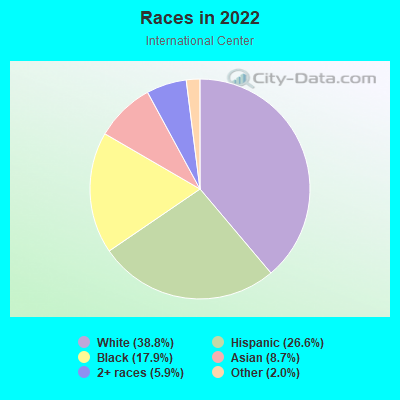
- 3,31738.8%White
- 2,27426.6%Hispanic or Latino
- 1,53417.9%Black
- 7428.7%Asian
- 5055.9%Two or more races
- 1752.0%Some other race
Median household income in 2022:
| International Center: | $87,032 |
| Bolingbrook: | $91,928 |
Distribution of median household income
![Distribution of median household income]()
- 197Less than $10,000
- 114$10,000 to $19,999
- 269$20,000 to $29,999
- 181$30,000 to $39,999
- 863$40,000 to $49,999
- 536$50,000 to $59,999
- 253$60,000 to $74,999
- 437$75,000 to $99,999
- 352$100,000 to $124,999
- 327$125,000 to $149,999
- 177$150,000 to $199,999
- 278$200,000 or more

Distribution of owner-occupied house/condo value
![Distribution of owner-occupied house/condo value]()
- 1,012Less than $50,000
- 1,829$50,000 to $99,999
- 243$100,000 to $149,999
- 756$150,000 to $199,999
- 537$200,000 to $249,999
- 180$250,000 to $299,999
- 520$300,000 to $399,999
- 234$400,000 to $499,999
- 110$500,000 to $749,999
- 336$1,000,000 or more

Distribution of rent paid by renters
![Distribution of rent paid by renters]()
- 34Less than $100
- 403$400 to $499
- 103$500 to $599
- 271$600 to $699
- 2,551$700 to $799
- 44$800 to $899
- 672$900 to $999
- 129$1,000 to $1,249
- 261$1,250 to $1,499
- 21$1,500 to $1,999
- 25$2,000 or more

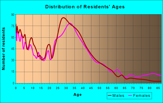
| Males: | 3,745 |
| Females: | 3,693 |
Males:
| This neighborhood: | 44.5 years |
| Whole city: | 40.3 years |
| This neighborhood: | 39.6 years |
| Whole city: | 41.4 years |
Average household size:
| International Center: | 3.0 people |
| Bolingbrook: | 2.8 people |
Percentage of family households:
| International Center: | 67.8% |
| Bolingbrook: | 53.7% |
| Here: | 50.5% |
| Bolingbrook: | 57.4% |
Percentage of married-couple families with children (among all households):
| International Center: | 20.2% |
| Bolingbrook: | 26.8% |
Percentage of single-mother households (among all households):
| International Center: | 8.8% |
| Bolingbrook: | 7.0% |
Percentage of never married males 15 years old and over:
Percentage of never married females 15 years old and over:
| International Center: | 20.0% |
| Bolingbrook: | 18.1% |
Percentage of never married females 15 years old and over:
| International Center: | 18.5% |
| village: | 14.7% |
Percentage of people that speak English not well or not at all:
| International Center: | 3.9% |
| Bolingbrook: | 4.8% |
Percentage of people born in this state:
Percentage of people born in another U.S. state:
Percentage of native residents but born outside the U.S.:
Percentage of foreign born residents:
| Here: | 71.2% |
| Bolingbrook: | 60.8% |
Percentage of people born in another U.S. state:
| International Center: | 7.9% |
| Bolingbrook: | 12.9% |
Percentage of native residents but born outside the U.S.:
| Here: | 0.7% |
| village: | 0.8% |
Percentage of foreign born residents:
| Here: | 20.2% |
| Bolingbrook: | 25.6% |
Owner-occupied
Renter-occupied

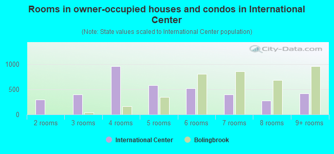
- Rooms in owner-occupied houses and condos in International Center
- 01 room
- 3012 rooms
- 3993 rooms
- 9644 rooms
- 5885 rooms
- 5246 rooms
- 3967 rooms
- 2828 rooms
- 4219+ rooms

- Rooms in renter-occupied apartments in International Center
- 01 room
- 312 rooms
- 933 rooms
- 8054 rooms
- 185 rooms
- 546 rooms
- 2347 rooms
- 2448 rooms
- 399+ rooms
Owner-occupied
Renter-occupied

- Bedrooms in owner-occupied houses and condos in International Center
- 0no bedroom
- 3011 bedroom
- 9902 bedrooms
- 1,2343 bedrooms
- 4724 bedrooms
- 2325+ bedrooms
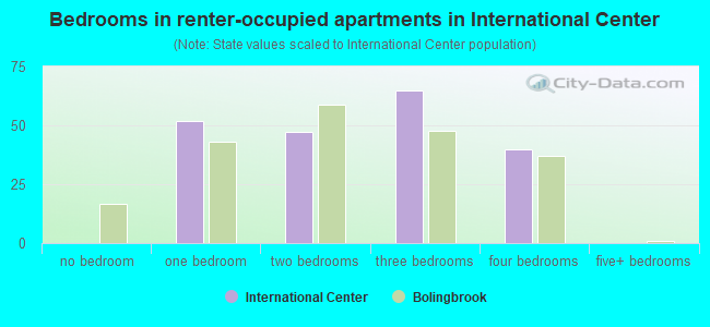
- Bedrooms in renter-occupied apartments in International Center
- 0no bedroom
- 521 bedroom
- 472 bedrooms
- 653 bedrooms
- 404 bedrooms
- 05+ bedrooms
Average number of cars or other vehicles available in houses/condos:
Average number of cars or other vehicles available in apartments:
| This neighborhood: | 14.5 |
| Bolingbrook: | 2.1 |
Average number of cars or other vehicles available in apartments:
| Here: | |
| village: |
Percentage of units with a mortgage:
| International Center: | 77.7% |
| Bolingbrook: | 72.8% |
Average estimated value of detached houses in 2022 (61.8% of all units):
| International Center: | $290,898 |
| Illinois: | $310,164 |
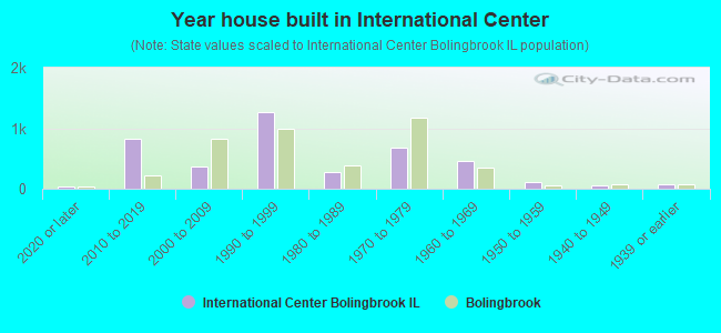
- Year house built in International Center
- 372020 or later
- 8192010 to 2019
- 3672000 to 2009
- 1,2701990 to 1999
- 2751980 to 1989
- 6871970 to 1979
- 4651960 to 1969
- 1061950 to 1959
- 611940 to 1949
- 661939 or earlier
City-data.com crime index for village in 2020 (higher means more crime):
| City: | 93.0 |
| U.S. average: | 219.5 |
Travel time to work (commute)
![Travel time to work (commute)]()
- 70Less than 5 minutes
- 2565 to 9 minutes
- 33210 to 14 minutes
- 27515 to 19 minutes
- 32420 to 24 minutes
- 21725 to 29 minutes
- 47230 to 34 minutes
- 9735 to 39 minutes
- 6840 to 44 minutes
- 49745 to 59 minutes
- 40860 to 89 minutes
- 7290 or more minutes

Means of transportation to work
![Means of transportation to work]()
- 78.7%3,121Drove a car alone
- 9.2%365Carpooled
- 0.7%26Bus
- 1.7%66Long-distance train or commuter rail
- 19.0%752Light rail, streetcar or trolley
- 1.5%58Taxi
- 1.6%62Bicycle
- 1.9%76Walked
- 15.8%626Other means
- 5.5%219Worked at home

Time leaving home to go to work
![Time leaving home to go to work]()
- 32112:00 a.m. to 4:59 a.m.
- 915:00 a.m. to 5:29 a.m.
- 4705:30 a.m. to 5:59 a.m.
- 2066:00 a.m. to 6:29 a.m.
- 3246:30 a.m. to 6:59 a.m.
- 1947:00 a.m. to 7:29 a.m.
- 2707:30 a.m. to 7:59 a.m.
- 1648:00 a.m. to 8:29 a.m.
- 1558:30 a.m. to 8:59 a.m.
- 1959:00 a.m. to 9:59 a.m.
- 5810:00 a.m. to 10:59 a.m.
- 5411:00 a.m. to 11:59 a.m.
- 39812:00 p.m. to 3:59 p.m.
- 1614:00 p.m. to 11:59 p.m.

Occupations of males:
- Percentage of males in management occupations (except farmers):
Here: 10.7% village: 13.3%
- Percentage of males in business and financial operations occupations:
Here: 2.0% village: 4.7%
- Percentage of males in computer and mathematical occupations:
Here: 1.0% village: 7.1%
- Percentage of males in service occupations:
Here: 20.4% village: 11.0%
- Percentage of males in sales and office occupations:
Here: 17.8% village: 16.8%
- Percentage of males in construction, extraction, and maintenance occupations:
Here: 13.2% village: 7.0%
- Percentage of males in production occupations:
Here: 2.8% village: 8.4%
- Percentage of males in transportation occupations:
Here: 9.4% village: 6.6%
- Percentage of males in material moving occupations:
Here: 14.1% village: 9.2%
Occupations of females:
- Percentage of females in management occupations (except farmers):
Here: 6.7% village: 9.2%
- Percentage of females in business and financial operations occupations:
Here: 4.6% village: 8.3%
- Percentage of females in computer and mathematical occupations:
Here: 2.5% village: 2.8%
- Percentage of females in community and social services occupations:
Here: 1.3% village: 2.2%
- Percentage of females in education, training, and library occupations:
Here: 3.1% village: 7.5%
- Percentage of females in healthcare practitioners and technical occupations:
Here: 16.9% village: 11.2%
- Percentage of females in service occupations:
Here: 23.1% village: 16.1%
- Percentage of females in sales and office occupations:
Here: 38.4% village: 29.0%
- Percentage of females in production occupations:
Here: 2.6% village: 4.0%
Percentage of people 16-64 in Armed Forces:
| International Center: | 0.0% |
| Bolingbrook: | 0.0% |
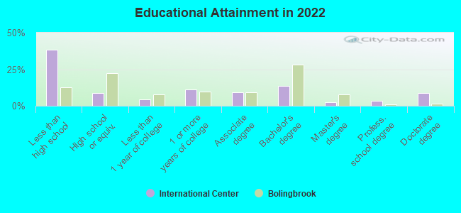
Education in this neighborhood (subdivision or community):
- Percentage of people 3 years and older in K-12 schools:
International Center: 30.4% Bolingbrook: 17.2%
- Percentage of people 3 years and older in undergraduate colleges:
International Center: 9.3% Bolingbrook: 4.0%
- Percentage of people 3 years and older in grad. or professional schools:
International Center: 2.2% Bolingbrook: 1.7%
- Percentage of students K-12 enrolled in private schools:
International Center: 81.3% Bolingbrook: 5.1%
Percentage of population below poverty level:
| International Center: | 9.0% |
| Bolingbrook: | 8.6% |
Median year owner moved in (as recorded in 2022):
| International Center: | 2004 |
| Bolingbrook: | 2008 |
Percentage of married-couple families with both working:
| International Center: | 95.0% |
| Bolingbrook: | 74.8% |
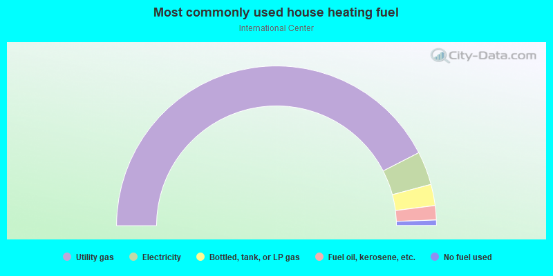
- 84.9%Utility gas
- 6.8%Electricity
- 4.3%Bottled, tank, or LP gas
- 2.9%Fuel oil, kerosene, etc.
- 1.1%No fuel used
Limited-access highways (interstate or state) in this neighborhood:
I- 55
Length: 0.41 miles
Directions: E-W, SW-NE
Directions: E-W, SW-NE
Roads and streets:
Internationale Pkwy
Length: 1.58 miles
Directions: E-W, SW-NE
Address range: 1000 to 2459
Directions: E-W, SW-NE
Address range: 1000 to 2459
Davey Rd
Length: 1.08 miles
Directions: E-W, SE-NW, SW-NE
Address range: 1401 to 17455
Directions: E-W, SE-NW, SW-NE
Address range: 1401 to 17455
101st St
Length: 1.04 miles
Direction: E-W
Address range: 1003 to 1799
Direction: E-W
Address range: 1003 to 1799
103rd St
Length: 0.89 miles
Direction: E-W
Address range: 15848 to 16799
Direction: E-W
Address range: 15848 to 16799
Woodward Ave
Length: 0.89 miles
Directions: N-S, SE-NW
Directions: N-S, SE-NW
International Pkwy (Internationale Pkwy)
Length: 0.78 miles
Directions: E-W, SW-NE
Address range: 1600 to 1898
Directions: E-W, SW-NE
Address range: 1600 to 1898
Werch Dr
Length: 0.65 miles
Directions: E-W, N-S, SE-NW, SW-NE
Address range: 10220 to 10321
Directions: E-W, N-S, SE-NW, SW-NE
Address range: 10220 to 10321
Lemont Rd
Length: 0.64 miles
Direction: N-S
Direction: N-S
Length: 0.27 miles
Direction: E-W
Direction: E-W
Argonne Dr
Length: 0.25 miles
Direction: N-S
Address range: 10304 to 10399
Direction: N-S
Address range: 10304 to 10399
Morey Dr
Length: 0.24 miles
Direction: N-S
Direction: N-S
Rising Ct
Length: 0.12 miles
Directions: N-S, SE-NW
Directions: N-S, SE-NW
Argonne Woods Dr
Length: 0.10 miles
Direction: N-S
Address range: 10300 to 10499
Direction: N-S
Address range: 10300 to 10499
Murphy Rd
Length: 0.05 miles
Direction: SE-NW
Direction: SE-NW
Length: 0.03 miles
Direction: N-S
Direction: N-S
Railroad features:
at and Sf Rlwy
Length: 1.76 miles
Directions: E-W, N-S, SW-NE
Directions: E-W, N-S, SW-NE
Atchison Topeka and Santa Fe RR
Length: 0.28 miles
Direction: E-W
Direction: E-W
Other features:
Black Partridge Crk
Length: 0.56 miles
Directions: E-W, N-S, SE-NW
Directions: E-W, N-S, SE-NW
Limited-access highways (interstate or state) in this neighborhood:
I- 55
Length: 10.00 miles
Directions: E-W, SW-NE
Directions: E-W, SW-NE
Highways in this neighborhood:
Joliet Rd
Length: 2.81 miles
Directions: N-S, SW-NE
Address range: 100 to 11357
Directions: N-S, SW-NE
Address range: 100 to 11357
S Bolingbrook Dr (State Rte 53)
Length: 1.09 miles
Direction: N-S
Address range: 300 to 650
Direction: N-S
Address range: 300 to 650
State Rte 53 (Bolingbrook Dr)
Length: 0.92 miles
Directions: N-S, SW-NE
Address range: 1300 to 1399
Directions: N-S, SW-NE
Address range: 1300 to 1399
N Independence Blvd (State Rte 53)
Length: 0.68 miles
Direction: SW-NE
Address range: 1254 to 1499
Direction: SW-NE
Address range: 1254 to 1499
Roads and streets:
Crossroads Pkwy
Length: 4.91 miles
Directions: E-W, N-S, SE-NW, SW-NE
Address range: 100 to 1199
Directions: E-W, N-S, SE-NW, SW-NE
Address range: 100 to 1199
Remington Blvd
Length: 4.68 miles
Directions: E-W, N-S, SE-NW, SW-NE
Address range: 103 to 1699
Directions: E-W, N-S, SE-NW, SW-NE
Address range: 103 to 1699
S Frontage Rd
Length: 3.39 miles
Directions: E-W, N-S, SE-NW, SW-NE
Address range: 1 to 11999
Directions: E-W, N-S, SE-NW, SW-NE
Address range: 1 to 11999
SW Frontage Rd
Length: 2.89 miles
Directions: E-W, N-S, SW-NE
Address range: 12857 to 13299
Directions: E-W, N-S, SW-NE
Address range: 12857 to 13299
Normantown Rd
Length: 2.71 miles
Directions: E-W, N-S, SW-NE
Address range: 20652 to 20799
Directions: E-W, N-S, SW-NE
Address range: 20652 to 20799
N Frontage Rd
Length: 2.67 miles
Directions: E-W, SW-NE
Address range: 200 to 280
Directions: E-W, SW-NE
Address range: 200 to 280
I-55 (I 55 Nb)
Length: 2.31 miles
Directions: E-W, SW-NE
Directions: E-W, SW-NE
E South Frontage Rd
Length: 2.10 miles
Directions: E-W, SE-NW, SW-NE
Address range: 503 to 699
Directions: E-W, SE-NW, SW-NE
Address range: 503 to 699
Bluff Rd
Length: 2.03 miles
Directions: E-W, SW-NE
Address range: 1401 to 17828
Directions: E-W, SW-NE
Address range: 1401 to 17828
W Normantown Rd
Length: 1.90 miles
Directions: E-W, SE-NW
Address range: 1001 to 20589
Directions: E-W, SE-NW
Address range: 1001 to 20589
S Schmidt Rd (Schmidt Rd)
Length: 1.85 miles
Direction: N-S
Address range: 600 to 699
Direction: N-S
Address range: 600 to 699
Davey Rd
Length: 1.56 miles
Directions: E-W, SW-NE
Directions: E-W, SW-NE
Naperville Dr (Naper-Romeo Rd)
Length: 1.53 miles
Directions: E-W, N-S, SW-NE
Address range: 101 to 1399
Directions: E-W, N-S, SW-NE
Address range: 101 to 1399
Old Chicago Dr
Length: 1.34 miles
Directions: E-W, N-S, SE-NW, SW-NE
Address range: 1 to 599
Directions: E-W, N-S, SE-NW, SW-NE
Address range: 1 to 599
Internationale Pkwy (Internationale Pkwy)
Length: 1.28 miles
Directions: E-W, SE-NW, SW-NE
Directions: E-W, SE-NW, SW-NE
Veterans Pkwy (S Naper Romeo Rd, S Naperville Rd)
Length: 1.23 miles
Direction: SE-NW
Address range: 1338 to 12451
Direction: SE-NW
Address range: 1338 to 12451
Territorial Dr
Length: 1.18 miles
Directions: E-W, N-S, SE-NW, SW-NE
Address range: 500 to 699
Directions: E-W, N-S, SE-NW, SW-NE
Address range: 500 to 699
S Naperville Rd (Naper-Romeo Rd)
Length: 1.14 miles
Directions: E-W, SE-NW
Address range: 12452 to 13499
Directions: E-W, SE-NW
Address range: 12452 to 13499
Normantown Rd (Frontage Rd)
Length: 1.11 miles
Directions: E-W, N-S, SW-NE
Address range: 20592 to 20651
Directions: E-W, N-S, SW-NE
Address range: 20592 to 20651
Weber Rd
Length: 1.09 miles
Direction: N-S
Direction: N-S
W S Frontage Rd
Length: 1.08 miles
Directions: E-W, SW-NE
Address range: 100 to 299
Directions: E-W, SW-NE
Address range: 100 to 299
Lakeview Dr
Length: 1.05 miles
Directions: E-W, N-S, SW-NE
Address range: 1200 to 1344
Directions: E-W, N-S, SW-NE
Address range: 1200 to 1344
Marquette Dr
Length: 1.04 miles
Directions: E-W, SW-NE
Address range: 200 to 1399
Directions: E-W, SW-NE
Address range: 200 to 1399
Rebecca Ln
Length: 1.03 miles
Directions: E-W, N-S, SE-NW, SW-NE
Address range: 400 to 899
Directions: E-W, N-S, SE-NW, SW-NE
Address range: 400 to 899
Dalton Ln
Length: 0.90 miles
Directions: E-W, N-S, SE-NW
Directions: E-W, N-S, SE-NW
Bluebird Dr
Length: 0.89 miles
Directions: E-W, N-S, SW-NE
Address range: 400 to 899
Directions: E-W, N-S, SW-NE
Address range: 400 to 899
Woodcreek Dr
Length: 0.87 miles
Directions: N-S, SE-NW, SW-NE
Address range: 328 to 699
Directions: N-S, SE-NW, SW-NE
Address range: 328 to 699
Wallace Way (Wallace Way)
Length: 0.87 miles
Directions: E-W, SW-NE
Directions: E-W, SW-NE
W 115th St
Length: 0.86 miles
Directions: E-W, SW-NE
Address range: 1100 to 20347
Directions: E-W, SW-NE
Address range: 1100 to 20347
Windham Pkwy
Length: 0.84 miles
Direction: E-W
Address range: 1100 to 1297
Direction: E-W
Address range: 1100 to 1297
Beaudin Blvd
Length: 0.81 miles
Directions: N-S, SE-NW
Directions: N-S, SE-NW
Gibralter Dr
Length: 0.81 miles
Directions: E-W, SE-NW, SW-NE
Address range: 200 to 499
Directions: E-W, SE-NW, SW-NE
Address range: 200 to 499
Enterprise Dr
Length: 0.77 miles
Directions: N-S, SE-NW, SW-NE
Address range: 1200 to 1499
Directions: N-S, SE-NW, SW-NE
Address range: 1200 to 1499
St James Gate
Length: 0.73 miles
Directions: E-W, N-S, SE-NW
Address range: 500 to 599
Directions: E-W, N-S, SE-NW
Address range: 500 to 599
Kingsbrooke Xing
Length: 0.73 miles
Directions: E-W, N-S, SE-NW
Address range: 400 to 799
Directions: E-W, N-S, SE-NW
Address range: 400 to 799
W 119th St (Rodeo Dr)
Length: 0.67 miles
Direction: E-W
Address range: 21033 to 21450
Direction: E-W
Address range: 21033 to 21450
E 107th St
Length: 0.65 miles
Direction: E-W
Address range: 600 to 698
Direction: E-W
Address range: 600 to 698
Fox Bend Cir
Length: 0.63 miles
Directions: E-W, N-S, SE-NW, SW-NE
Address range: 146 to 398
Directions: E-W, N-S, SE-NW, SW-NE
Address range: 146 to 398
Wildflower Way
Length: 0.56 miles
Directions: E-W, N-S, SE-NW, SW-NE
Address range: 300 to 699
Directions: E-W, N-S, SE-NW, SW-NE
Address range: 300 to 699
Carlow Dr
Length: 0.56 miles
Directions: E-W, N-S, SE-NW
Address range: 900 to 999
Directions: E-W, N-S, SE-NW
Address range: 900 to 999
Lakeside Dr
Length: 0.54 miles
Directions: N-S, SE-NW
Address range: 1200 to 1399
Directions: N-S, SE-NW
Address range: 1200 to 1399
Remington Bl
Length: 0.53 miles
Direction: E-W
Direction: E-W
Hillcrest Dr
Length: 0.51 miles
Direction: E-W
Address range: 400 to 799
Direction: E-W
Address range: 400 to 799
Orchard Dr
Length: 0.50 miles
Directions: E-W, N-S
Address range: 300 to 517
Directions: E-W, N-S
Address range: 300 to 517
Honeytree Dr
Length: 0.49 miles
Directions: E-W, N-S, SE-NW, SW-NE
Address range: 2 to 599
Directions: E-W, N-S, SE-NW, SW-NE
Address range: 2 to 599
Internationale Blvd (Internationale Dr)
Length: 0.45 miles
Directions: E-W, SE-NW
Address range: 200 to 399
Directions: E-W, SE-NW
Address range: 200 to 399
Six Pines Dr
Length: 0.45 miles
Directions: E-W, N-S, SE-NW, SW-NE
Address range: 102 to 899
Directions: E-W, N-S, SE-NW, SW-NE
Address range: 102 to 899
Marmon Dr
Length: 0.43 miles
Direction: N-S
Address range: 300 to 399
Direction: N-S
Address range: 300 to 399
Bush Bl
Length: 0.42 miles
Directions: E-W, N-S, SE-NW, SW-NE
Directions: E-W, N-S, SE-NW, SW-NE
S 224th Ave (Essington Rd)
Length: 0.41 miles
Direction: N-S
Address range: 1478 to 13131
Direction: N-S
Address range: 1478 to 13131
Anton Dr
Length: 0.41 miles
Direction: E-W
Address range: 100 to 199
Direction: E-W
Address range: 100 to 199
Arbor Dr
Length: 0.41 miles
Direction: E-W
Address range: 1100 to 1199
Direction: E-W
Address range: 1100 to 1199
N Sleepy Hollow Ln
Length: 0.40 miles
Directions: E-W, N-S, SE-NW
Directions: E-W, N-S, SE-NW
Quadrangle Dr
Length: 0.39 miles
Direction: N-S
Address range: 400 to 498
Direction: N-S
Address range: 400 to 498
Foxborough Trl
Length: 0.39 miles
Directions: E-W, N-S
Address range: 300 to 599
Directions: E-W, N-S
Address range: 300 to 599
Larkspur Dr (Larkspur St)
Length: 0.39 miles
Directions: E-W, N-S, SE-NW, SW-NE
Address range: 400 to 624
Directions: E-W, N-S, SE-NW, SW-NE
Address range: 400 to 624
N Misty Ridge Dr
Length: 0.38 miles
Directions: N-S, SE-NW, SW-NE
Directions: N-S, SE-NW, SW-NE
Crossing Rd
Length: 0.36 miles
Direction: SW-NE
Address range: 300 to 399
Direction: SW-NE
Address range: 300 to 399
Lindsey Ln
Length: 0.36 miles
Direction: SW-NE
Direction: SW-NE
Brunswick Ln
Length: 0.35 miles
Directions: N-S, SW-NE
Directions: N-S, SW-NE
Pro Logis Pkwy
Length: 0.34 miles
Directions: N-S, SE-NW
Directions: N-S, SE-NW
Katherines Xing
Length: 0.33 miles
Direction: N-S
Direction: N-S
Columbine Ln (Columbine Dr)
Length: 0.33 miles
Directions: E-W, N-S, SE-NW, SW-NE
Address range: 401 to 599
Directions: E-W, N-S, SE-NW, SW-NE
Address range: 401 to 599
Hejka Ln
Length: 0.32 miles
Directions: N-S, SW-NE
Directions: N-S, SW-NE
Medical Center Dr
Length: 0.31 miles
Direction: E-W
Address range: 400 to 499
Direction: E-W
Address range: 400 to 499
Kings Rd
Length: 0.31 miles
Direction: N-S
Direction: N-S
Bell Flower Ln
Length: 0.30 miles
Directions: E-W, SE-NW
Address range: 808 to 872
Directions: E-W, SE-NW
Address range: 808 to 872
Romeo Rd (W 135th St, 135th)
Length: 0.30 miles
Direction: E-W
Direction: E-W
Gateway Dr
Length: 0.30 miles
Direction: SE-NW
Direction: SE-NW
Meadowlark Dr
Length: 0.29 miles
Directions: E-W, N-S, SE-NW, SW-NE
Address range: 300 to 498
Directions: E-W, N-S, SE-NW, SW-NE
Address range: 300 to 498
N Sunrise Dr
Length: 0.28 miles
Directions: E-W, N-S, SW-NE
Directions: E-W, N-S, SW-NE
Sherman Rd
Length: 0.27 miles
Directions: E-W, N-S, SW-NE
Address range: 1400 to 1499
Directions: E-W, N-S, SW-NE
Address range: 1400 to 1499
W Mystic Ln
Length: 0.27 miles
Directions: E-W, N-S, SE-NW
Directions: E-W, N-S, SE-NW
Lincoln Ave
Length: 0.27 miles
Direction: E-W
Direction: E-W
Bloomfield Dr
Length: 0.26 miles
Directions: E-W, SW-NE
Address range: 400 to 599
Directions: E-W, SW-NE
Address range: 400 to 599
Alcott Ln
Length: 0.26 miles
Direction: E-W
Address range: 500 to 599
Direction: E-W
Address range: 500 to 599
Honeybear Ln
Length: 0.24 miles
Direction: E-W
Address range: 1 to 99
Direction: E-W
Address range: 1 to 99
Cloverdale Ln
Length: 0.24 miles
Direction: E-W
Address range: 800 to 899
Direction: E-W
Address range: 800 to 899
Greystone Ln
Length: 0.23 miles
Direction: E-W
Address range: 500 to 699
Direction: E-W
Address range: 500 to 699
Normantown Rd (W 127th St)
Length: 0.23 miles
Direction: E-W
Address range: 21176 to 21218
Direction: E-W
Address range: 21176 to 21218
Theodore Ct
Length: 0.23 miles
Direction: N-S
Address range: 700 to 799
Direction: N-S
Address range: 700 to 799
Plainview Dr
Length: 0.21 miles
Directions: N-S, SE-NW, SW-NE
Address range: 342 to 422
Directions: N-S, SE-NW, SW-NE
Address range: 342 to 422
Hummingbird Ln
Length: 0.21 miles
Directions: E-W, N-S, SE-NW
Address range: 300 to 499
Directions: E-W, N-S, SE-NW
Address range: 300 to 499
Monarch Ln
Length: 0.21 miles
Directions: E-W, N-S, SW-NE
Address range: 389 to 499
Directions: E-W, N-S, SW-NE
Address range: 389 to 499
Earl Ct
Length: 0.21 miles
Directions: E-W, N-S, SE-NW, SW-NE
Directions: E-W, N-S, SE-NW, SW-NE
Reagan Bl
Length: 0.20 miles
Directions: N-S, SE-NW
Directions: N-S, SE-NW
Cedarbend Dr
Length: 0.20 miles
Directions: E-W, SW-NE
Address range: 100 to 214
Directions: E-W, SW-NE
Address range: 100 to 214
W Hillcrest Dr
Length: 0.19 miles
Direction: E-W
Direction: E-W
Wilshire Ln
Length: 0.18 miles
Direction: N-S
Address range: 400 to 599
Direction: N-S
Address range: 400 to 599
Birchwood Dr
Length: 0.18 miles
Directions: E-W, N-S, SE-NW, SW-NE
Address range: 200 to 399
Directions: E-W, N-S, SE-NW, SW-NE
Address range: 200 to 399
Brookview Ln
Length: 0.18 miles
Directions: N-S, SE-NW
Directions: N-S, SE-NW
Highknob Rd
Length: 0.16 miles
Directions: N-S, SE-NW
Address range: 300 to 399
Directions: N-S, SE-NW
Address range: 300 to 399
Elmwood Rd
Length: 0.15 miles
Directions: E-W, N-S, SE-NW, SW-NE
Address range: 100 to 312
Directions: E-W, N-S, SE-NW, SW-NE
Address range: 100 to 312
Gardiner Ct
Length: 0.15 miles
Directions: E-W, N-S
Address range: 500 to 599
Directions: E-W, N-S
Address range: 500 to 599
Jane Addams Rd
Length: 0.15 miles
Directions: E-W, SE-NW
Address range: 863 to 887
Directions: E-W, SE-NW
Address range: 863 to 887
Territorial Ct
Length: 0.14 miles
Direction: N-S
Address range: 1 to 99
Direction: N-S
Address range: 1 to 99
Robbin Dr
Length: 0.14 miles
Directions: E-W, N-S, SE-NW, SW-NE
Address range: 100 to 299
Directions: E-W, N-S, SE-NW, SW-NE
Address range: 100 to 299
Payton Ln
Length: 0.14 miles
Direction: E-W
Address range: 500 to 599
Direction: E-W
Address range: 500 to 599
Fernwood Dr
Length: 0.14 miles
Direction: E-W
Direction: E-W
Chambers Dr
Length: 0.13 miles
Direction: SE-NW
Direction: SE-NW
Hosler Dr ()
Length: 0.13 miles
Direction: N-S
Direction: N-S
Timber Ct
Length: 0.13 miles
Direction: E-W
Address range: 1 to 99
Direction: E-W
Address range: 1 to 99
Farmbrook Ct
Length: 0.12 miles
Directions: E-W, N-S
Address range: 400 to 499
Directions: E-W, N-S
Address range: 400 to 499
Wildwood Ct
Length: 0.12 miles
Directions: E-W, N-S
Address range: 400 to 499
Directions: E-W, N-S
Address range: 400 to 499
Sammons Ct
Length: 0.12 miles
Directions: N-S, SE-NW
Address range: 1 to 99
Directions: N-S, SE-NW
Address range: 1 to 99
Allenhurst Ct
Length: 0.11 miles
Directions: E-W, N-S
Directions: E-W, N-S
Savannah Ln
Length: 0.11 miles
Direction: N-S
Address range: 400 to 599
Direction: N-S
Address range: 400 to 599
Vanessa Ln
Length: 0.11 miles
Direction: N-S
Address range: 400 to 599
Direction: N-S
Address range: 400 to 599
Overland Ct
Length: 0.11 miles
Direction: N-S
Direction: N-S
Naperville Rd
Length: 0.11 miles
Direction: N-S
Direction: N-S
Long Ln
Length: 0.10 miles
Direction: N-S
Address range: 400 to 499
Direction: N-S
Address range: 400 to 499
Fox Grove Ct
Length: 0.10 miles
Directions: N-S, SW-NE
Address range: 2 to 99
Directions: N-S, SW-NE
Address range: 2 to 99
Northpoint Ct
Length: 0.10 miles
Directions: N-S, SE-NW
Address range: 1 to 5
Directions: N-S, SE-NW
Address range: 1 to 5
Beechwood Rd
Length: 0.10 miles
Direction: E-W
Address range: 300 to 399
Direction: E-W
Address range: 300 to 399
Arbury Ct
Length: 0.09 miles
Directions: E-W, N-S
Address range: 700 to 799
Directions: E-W, N-S
Address range: 700 to 799
Saybrook Ct
Length: 0.09 miles
Directions: E-W, N-S
Address range: 700 to 799
Directions: E-W, N-S
Address range: 700 to 799
Pinetree Ct
Length: 0.09 miles
Directions: E-W, N-S
Address range: 700 to 799
Directions: E-W, N-S
Address range: 700 to 799
Sherwood Ct
Length: 0.09 miles
Directions: E-W, N-S
Address range: 600 to 699
Directions: E-W, N-S
Address range: 600 to 699
115th St
Length: 0.09 miles
Directions: E-W, N-S
Directions: E-W, N-S
Plainview Ct
Length: 0.09 miles
Directions: E-W, SW-NE
Address range: 1 to 11
Directions: E-W, SW-NE
Address range: 1 to 11
W Remington Bl
Length: 0.08 miles
Direction: E-W
Direction: E-W
Cranbrook Ct
Length: 0.08 miles
Direction: E-W
Address range: 500 to 599
Direction: E-W
Address range: 500 to 599
Gleneagle Ln
Length: 0.08 miles
Direction: N-S
Direction: N-S
Crossways Pkwy
Length: 0.07 miles
Directions: E-W, N-S, SW-NE
Directions: E-W, N-S, SW-NE
Stevenson Dr
Length: 0.07 miles
Directions: N-S, SE-NW
Address range: 400 to 499
Directions: N-S, SE-NW
Address range: 400 to 499
Willow Ct
Length: 0.07 miles
Direction: E-W
Address range: 500 to 599
Direction: E-W
Address range: 500 to 599
Hedgerow Ln
Length: 0.07 miles
Direction: SW-NE
Direction: SW-NE
Gateway Ct
Length: 0.06 miles
Direction: SE-NW
Address range: 1 to 99
Direction: SE-NW
Address range: 1 to 99
N Mother Ct
Length: 0.06 miles
Directions: N-S, SW-NE
Directions: N-S, SW-NE
Cedar Ct
Length: 0.06 miles
Direction: E-W
Address range: 600 to 699
Direction: E-W
Address range: 600 to 699
W Lakeview Ct
Length: 0.06 miles
Direction: E-W
Address range: 1200 to 1299
Direction: E-W
Address range: 1200 to 1299
I-355 (North-South Tollway, I 355 Sb)
Length: 0.06 miles
Direction: N-S
Direction: N-S
Brookside Ct
Length: 0.06 miles
Directions: N-S, SW-NE
Directions: N-S, SW-NE
Devon Ln
Length: 0.05 miles
Direction: E-W
Address range: 600 to 699
Direction: E-W
Address range: 600 to 699
Dunbridge Ln
Length: 0.05 miles
Direction: E-W
Address range: 900 to 999
Direction: E-W
Address range: 900 to 999
Harris Ln
Length: 0.05 miles
Direction: E-W
Address range: 800 to 899
Direction: E-W
Address range: 800 to 899
Windsor Ln
Length: 0.05 miles
Direction: E-W
Address range: 700 to 799
Direction: E-W
Address range: 700 to 799
Glenhurst Ct
Length: 0.05 miles
Direction: E-W
Address range: 600 to 722
Direction: E-W
Address range: 600 to 722
Chamberlin Dr
Length: 0.04 miles
Direction: N-S
Direction: N-S
Kingsbrooke Ct
Length: 0.04 miles
Directions: N-S, SE-NW
Address range: 1 to 99
Directions: N-S, SE-NW
Address range: 1 to 99
Walden Ct
Length: 0.04 miles
Direction: E-W
Address range: 400 to 499
Direction: E-W
Address range: 400 to 499
Rolling Meadows Ct
Length: 0.03 miles
Direction: SW-NE
Address range: 1 to 99
Direction: SW-NE
Address range: 1 to 99
Hedgerow Ct
Length: 0.03 miles
Direction: SW-NE
Address range: 1 to 99
Direction: SW-NE
Address range: 1 to 99
Railroad features:
at and Sf Rlwy
Length: 2.25 miles
Directions: E-W, N-S, SW-NE
Directions: E-W, N-S, SW-NE
Other features:
Lily Cache Crk
Length: 1.46 miles
Directions: E-W, N-S, SE-NW, SW-NE
Directions: E-W, N-S, SE-NW, SW-NE
Powerlines:
Commonwealth Edison Transmisson Line
Length: 0.84 miles
Direction: N-S
Direction: N-S
Other features:
Black Partridge Crk
Length: 0.08 miles
Directions: E-W, N-S, SW-NE
Directions: E-W, N-S, SW-NE