Hollydale neighborhood in South Gate, California (CA), 90242, 90262, 90280, 90723 detailed profile
Settings
X


Business Search - 14 Million verified businesses
Area: 2.017 square miles
Population: 19,842
Population density:
| Hollydale: | 9,839 people per square mile |
| South Gate: | 12,346 people per square mile |

- 16,42968.2%Hispanic or Latino
- 2,63010.9%Some other race
- 2,43910.1%Black
- 8853.7%Asian
- 8133.4%White
- 5892.4%Two or more races
- 3151.3%American Indian

Median household income in 2022:
| Hollydale: | $83,831 |
| South Gate: | $70,939 |
Distribution of median household income
![Distribution of median household income]()
- 194Less than $10,000
- 340$10,000 to $19,999
- 451$20,000 to $29,999
- 2,093$30,000 to $39,999
- 304$40,000 to $49,999
- 511$50,000 to $59,999
- 689$60,000 to $74,999
- 675$75,000 to $99,999
- 803$100,000 to $124,999
- 534$125,000 to $149,999
- 438$150,000 to $199,999
- 504$200,000 or more

Distribution of owner-occupied house/condo value
![Distribution of owner-occupied house/condo value]()
- 186Less than $50,000
- 305$50,000 to $99,999
- 23$100,000 to $149,999
- 637$150,000 to $199,999
- 175$200,000 to $249,999
- 51$250,000 to $299,999
- 192$300,000 to $399,999
- 811$400,000 to $499,999
- 1,258$500,000 to $749,999
- 302$750,000 to $999,999
- 774$1,000,000 or more

Distribution of rent paid by renters
![Distribution of rent paid by renters]()
- 20$200 to $299
- 109$300 to $399
- 361$400 to $499
- 114$500 to $599
- 204$600 to $699
- 62$700 to $799
- 368$800 to $899
- 211$900 to $999
- 496$1,000 to $1,249
- 383$1,250 to $1,499
- 826$1,500 to $1,999
- 1,981$2,000 or more

Median rent in 2022:
| Hollydale: | $1,494 |
| South Gate: | $1,326 |
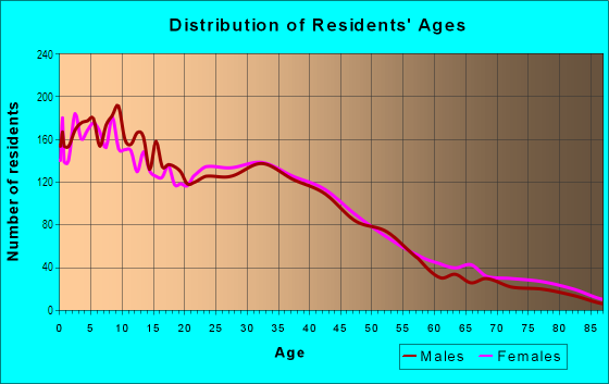
| Males: | 10,140 |
| Females: | 9,702 |
Males:
| This neighborhood: | 33.3 years |
| Whole city: | 35.2 years |
| This neighborhood: | 32.1 years |
| Whole city: | 34.6 years |
Average household size:
| Hollydale: | 8.0 people |
| South Gate: | 3.6 people |
Percentage of family households:
| Hollydale: | 61.0% |
| South Gate: | 54.9% |
| Here: | 53.2% |
| South Gate: | 49.6% |
Percentage of married-couple families with children (among all households):
| Hollydale: | 19.0% |
| South Gate: | 17.0% |
Percentage of single-mother households (among all households):
| Hollydale: | 5.0% |
| South Gate: | 7.6% |
Percentage of never married males 15 years old and over:
Percentage of never married females 15 years old and over:
| Hollydale: | 23.5% |
| South Gate: | 21.7% |
Percentage of never married females 15 years old and over:
| Hollydale: | 20.7% |
| city: | 22.9% |
Percentage of people that speak English not well or not at all:
| Hollydale: | 17.3% |
| South Gate: | 22.7% |
Percentage of people born in this state:
Percentage of people born in another U.S. state:
Percentage of native residents but born outside the U.S.:
Percentage of foreign born residents:
| Here: | 60.8% |
| South Gate: | 56.0% |
Percentage of people born in another U.S. state:
| Hollydale: | 2.9% |
| South Gate: | 3.0% |
Percentage of native residents but born outside the U.S.:
| Here: | 1.0% |
| city: | 1.2% |
Percentage of foreign born residents:
| Here: | 35.4% |
| South Gate: | 39.8% |

Owner-occupied
Renter-occupied


- Rooms in owner-occupied houses and condos in Hollydale
- 1141 room
- 562 rooms
- 1213 rooms
- 7124 rooms
- 7695 rooms
- 5886 rooms
- 2767 rooms
- 2188 rooms
- 3639+ rooms

- Rooms in renter-occupied apartments in Hollydale
- 2761 room
- 1592 rooms
- 5213 rooms
- 1,2134 rooms
- 1,3345 rooms
- 2026 rooms
- 2117 rooms
- 1688 rooms
- 1819+ rooms
Owner-occupied
Renter-occupied

- Bedrooms in owner-occupied houses and condos in Hollydale
- 125no bedroom
- 351 bedroom
- 8882 bedrooms
- 1,1373 bedrooms
- 5024 bedrooms
- 1145+ bedrooms

- Bedrooms in renter-occupied apartments in Hollydale
- 350no bedroom
- 5411 bedroom
- 1,4522 bedrooms
- 3663 bedrooms
- 1214 bedrooms
- 2205+ bedrooms
Average number of cars or other vehicles available in houses/condos:
Average number of cars or other vehicles available in apartments:
| This neighborhood: | 2.9 |
| South Gate: | 2.8 |
Average number of cars or other vehicles available in apartments:
| Here: | 2.0 |
| city: | 1.6 |
Percentage of units with a mortgage:
| Hollydale: | 78.1% |
| South Gate: | 71.1% |
Average estimated value of detached houses in 2022 (55.5% of all units):
| Hollydale: | $601,545 |
| California: | $988,808 |

- Year house built in Hollydale
- 02020 or later
- 5202010 to 2019
- 1,0262000 to 2009
- 9611990 to 1999
- 1,3191980 to 1989
- 4791970 to 1979
- 3491960 to 1969
- 1,0871950 to 1959
- 1,0231940 to 1949
- 6331939 or earlier

City-data.com crime index for city in 2020 (higher means more crime):
| City: | 346.8 |
| U.S. average: | 219.5 |
Travel time to work (commute)
![Travel time to work (commute)]()
- 59Less than 5 minutes
- 4515 to 9 minutes
- 84210 to 14 minutes
- 98315 to 19 minutes
- 1,56220 to 24 minutes
- 30725 to 29 minutes
- 2,07430 to 34 minutes
- 14635 to 39 minutes
- 15740 to 44 minutes
- 78445 to 59 minutes
- 76760 to 89 minutes
- 40690 or more minutes

Means of transportation to work
![Means of transportation to work]()
- 71.3%6,909Drove a car alone
- 14.0%1,353Carpooled
- 1.6%152Bus
- 0.5%50Light rail, streetcar or trolley
- 1.8%171Taxi
- 6.0%579Motorcycle
- 2.2%217Bicycle
- 2.0%194Walked
- 2.4%228Other means
- 8.4%815Worked at home

Time leaving home to go to work
![Time leaving home to go to work]()
- 94812:00 a.m. to 4:59 a.m.
- 6155:00 a.m. to 5:29 a.m.
- 6415:30 a.m. to 5:59 a.m.
- 1,2396:00 a.m. to 6:29 a.m.
- 6346:30 a.m. to 6:59 a.m.
- 8597:00 a.m. to 7:29 a.m.
- 6947:30 a.m. to 7:59 a.m.
- 5648:00 a.m. to 8:29 a.m.
- 3248:30 a.m. to 8:59 a.m.
- 5739:00 a.m. to 9:59 a.m.
- 18510:00 a.m. to 10:59 a.m.
- 6011:00 a.m. to 11:59 a.m.
- 57112:00 p.m. to 3:59 p.m.
- 6634:00 p.m. to 11:59 p.m.

Occupations of males:
- Percentage of males in management occupations (except farmers):
Here: 3.3% city: 4.1%
- Percentage of males in business and financial operations occupations:
Here: 1.4% city: 2.2%
- Percentage of males in computer and mathematical occupations:
Here: 1.9% city: 1.4%
- Percentage of males in education, training, and library occupations:
Here: 1.5% city: 2.4%
- Percentage of males in arts, design, entertainment, sports, and media occupations:
Here: 2.6% city: 0.7%
- Percentage of males in healthcare practitioners and technical occupations:
Here: 2.2% city: 1.1%
- Percentage of males in service occupations:
Here: 23.2% city: 14.7%
- Percentage of males in sales and office occupations:
Here: 12.0% city: 17.5%
- Percentage of males in construction, extraction, and maintenance occupations:
Here: 11.8% city: 12.8%
- Percentage of males in production occupations:
Here: 8.9% city: 13.8%
- Percentage of males in transportation occupations:
Here: 14.3% city: 13.4%
- Percentage of males in material moving occupations:
Here: 9.2% city: 9.8%
Occupations of females:
- Percentage of females in management occupations (except farmers):
Here: 4.5% city: 6.5%
- Percentage of females in business and financial operations occupations:
Here: 4.5% city: 3.4%
- Percentage of females in computer and mathematical occupations:
Here: 1.3% city: 0.2%
- Percentage of females in community and social services occupations:
Here: 1.6% city: 3.1%
- Percentage of females in education, training, and library occupations:
Here: 8.9% city: 6.0%
- Percentage of females in healthcare practitioners and technical occupations:
Here: 8.8% city: 5.4%
- Percentage of females in service occupations:
Here: 30.9% city: 25.8%
- Percentage of females in sales and office occupations:
Here: 27.8% city: 31.9%
- Percentage of females in production occupations:
Here: 3.5% city: 7.6%
- Percentage of females in transportation occupations:
Here: 2.1% city: 2.5%
- Percentage of females in material moving occupations:
Here: 5.2% city: 5.7%
Education in this neighborhood (subdivision or community):
- Percentage of people 3 years and older in K-12 schools:
Hollydale: 24.5% South Gate: 17.4%
- Percentage of people 3 years and older in undergraduate colleges:
Hollydale: 6.6% South Gate: 6.9%
- Percentage of people 3 years and older in grad. or professional schools:
Hollydale: 3.8% South Gate: 1.3%
- Percentage of students K-12 enrolled in private schools:
Hollydale: 17.7% South Gate: 4.9%
Percentage of population below poverty level:
| Hollydale: | 15.2% |
| South Gate: | 17.5% |
Median year owner moved in (as recorded in 2022):
Median year renter moved in (as recorded in 2022):
| Hollydale: | 2005 |
| South Gate: | 2002 |
Median year renter moved in (as recorded in 2022):
| Hollydale: | 2012 |
| South Gate: | 2016 |
Percentage of married-couple families with both working:
| Hollydale: | 63.2% |
| South Gate: | 47.0% |

- 58.4%Utility gas
- 24.7%Electricity
- 5.6%No fuel used
- 5.4%Solar energy
- 3.0%Bottled, tank, or LP gas
- 2.1%Wood
- 0.9%Other fuel
Limited-access highways (interstate or state) in this neighborhood:
Glenn M Anderson Freeway and Transit (Interstate Highway 105, Century Freeway, I- 105, Glenn M Anderson Freeway and Transit, Century Fwy)
Length: 2.83 miles
Direction: E-W
Direction: E-W
Long Beach Fwy (I- 710)
Length: 1.68 miles
Direction: N-S
Direction: N-S
Highways in this neighborhood:
State Rte 90 (E Imperial Hwy, Imperial Hwy)
Length: 0.24 miles
Directions: E-W, SE-NW
Address range: 7746 to 7931
Directions: E-W, SE-NW
Address range: 7746 to 7931
Roads and streets:
Gardendale St
Length: 1.75 miles
Directions: E-W, N-S, SE-NW, SW-NE
Address range: 5400 to 8199
Directions: E-W, N-S, SE-NW, SW-NE
Address range: 5400 to 8199
McKinley Ave
Length: 1.32 miles
Directions: E-W, SE-NW
Address range: 5500 to 8199
Directions: E-W, SE-NW
Address range: 5500 to 8199
Garfield Ave
Length: 1.24 miles
Directions: N-S, SE-NW
Address range: 10989 to 13825
Directions: N-S, SE-NW
Address range: 10989 to 13825
Martin Luther King Jr Blvd (Century Blvd)
Length: 1.16 miles
Directions: E-W, N-S, SE-NW
Address range: 5400 to 8099
Directions: E-W, N-S, SE-NW
Address range: 5400 to 8099
Main St
Length: 0.94 miles
Directions: E-W, SE-NW
Address range: 5546 to 6199
Directions: E-W, SE-NW
Address range: 5546 to 6199
Paramount Blvd
Length: 0.92 miles
Directions: N-S, SW-NE
Address range: 12740 to 13799
Directions: N-S, SW-NE
Address range: 12740 to 13799
Wright Rd
Length: 0.73 miles
Directions: N-S, SW-NE
Address range: 10975 to 12603
Directions: N-S, SW-NE
Address range: 10975 to 12603
Wilson Ave
Length: 0.70 miles
Directions: E-W, SE-NW
Address range: 5700 to 6199
Directions: E-W, SE-NW
Address range: 5700 to 6199
Roosevelt Ave
Length: 0.66 miles
Directions: E-W, SE-NW
Address range: 5700 to 6199
Directions: E-W, SE-NW
Address range: 5700 to 6199
Center St
Length: 0.64 miles
Directions: N-S, SE-NW
Address range: 11500 to 12599
Directions: N-S, SE-NW
Address range: 11500 to 12599
Consuelo St
Length: 0.60 miles
Directions: E-W, N-S, SE-NW, SW-NE
Address range: 7600 to 7999
Directions: E-W, N-S, SE-NW, SW-NE
Address range: 7600 to 7999
Industrial Ave
Length: 0.60 miles
Direction: N-S
Address range: 11700 to 12599
Direction: N-S
Address range: 11700 to 12599
Harding Ave
Length: 0.59 miles
Directions: E-W, SE-NW
Address range: 5700 to 6199
Directions: E-W, SE-NW
Address range: 5700 to 6199
Utah Ave
Length: 0.57 miles
Direction: N-S
Address range: 11300 to 12199
Direction: N-S
Address range: 11300 to 12199
Oklahoma Ave
Length: 0.57 miles
Direction: N-S
Address range: 11300 to 12199
Direction: N-S
Address range: 11300 to 12199
Pennsylvania Ave
Length: 0.57 miles
Direction: N-S
Address range: 11300 to 12199
Direction: N-S
Address range: 11300 to 12199
Lincoln Ave
Length: 0.57 miles
Directions: E-W, SE-NW
Address range: 5700 to 6199
Directions: E-W, SE-NW
Address range: 5700 to 6199
Florence Ave
Length: 0.57 miles
Directions: E-W, SE-NW
Address range: 5700 to 8299
Directions: E-W, SE-NW
Address range: 5700 to 8299
Brock Ave
Length: 0.55 miles
Directions: N-S, SW-NE
Address range: 12743 to 13455
Directions: N-S, SW-NE
Address range: 12743 to 13455
Monroe Ave
Length: 0.55 miles
Directions: E-W, SW-NE
Address range: 5400 to 5799
Directions: E-W, SW-NE
Address range: 5400 to 5799
Erickson Ave
Length: 0.51 miles
Directions: N-S, SE-NW, SW-NE
Address range: 12650 to 13099
Directions: N-S, SE-NW, SW-NE
Address range: 12650 to 13099
Hoover Ave
Length: 0.51 miles
Direction: SW-NE
Address range: 11700 to 12599
Direction: SW-NE
Address range: 11700 to 12599
Flores St
Length: 0.50 miles
Directions: E-W, SE-NW
Address range: 7300 to 7699
Directions: E-W, SE-NW
Address range: 7300 to 7699
Bonita St
Length: 0.49 miles
Directions: SE-NW, SW-NE
Address range: 7400 to 7599
Directions: SE-NW, SW-NE
Address range: 7400 to 7599
Cortland Ave
Length: 0.48 miles
Directions: E-W, N-S
Address range: 7100 to 7499
Directions: E-W, N-S
Address range: 7100 to 7499
Louise Ave
Length: 0.47 miles
Directions: N-S, SW-NE
Address range: 11000 to 11316
Directions: N-S, SW-NE
Address range: 11000 to 11316
Puritan St
Length: 0.43 miles
Direction: SE-NW
Address range: 7800 to 8099
Direction: SE-NW
Address range: 7800 to 8099
Smallwood Ave
Length: 0.43 miles
Directions: N-S, SW-NE
Address range: 12600 to 12999
Directions: N-S, SW-NE
Address range: 12600 to 12999
Amigos Ave
Length: 0.43 miles
Directions: SE-NW, SW-NE
Address range: 7400 to 7799
Directions: SE-NW, SW-NE
Address range: 7400 to 7799
Dakota Ave
Length: 0.34 miles
Direction: N-S
Direction: N-S
Orange Ave
Length: 0.34 miles
Direction: N-S
Address range: 13500 to 13699
Direction: N-S
Address range: 13500 to 13699
S Somerset Ranch Rd
Length: 0.34 miles
Direction: E-W
Direction: E-W
Walnut Ave
Length: 0.33 miles
Directions: E-W, SE-NW
Address range: 7200 to 7499
Directions: E-W, SE-NW
Address range: 7200 to 7499
Merkel Ave
Length: 0.33 miles
Directions: N-S, SW-NE
Address range: 13200 to 13599
Directions: N-S, SW-NE
Address range: 13200 to 13599
Cloverlawn Dr
Length: 0.33 miles
Directions: E-W, N-S, SE-NW
Address range: 7100 to 7499
Directions: E-W, N-S, SE-NW
Address range: 7100 to 7499
Alhambra Ave
Length: 0.32 miles
Direction: SE-NW
Address range: 8000 to 8199
Direction: SE-NW
Address range: 8000 to 8199
Idaho Ave
Length: 0.32 miles
Directions: N-S, SW-NE
Address range: 11300 to 11699
Directions: N-S, SW-NE
Address range: 11300 to 11699
Adoree St
Length: 0.30 miles
Direction: SE-NW
Address range: 7800 to 8099
Direction: SE-NW
Address range: 7800 to 8099
Comolette St
Length: 0.30 miles
Direction: SE-NW
Address range: 7800 to 8101
Direction: SE-NW
Address range: 7800 to 8101
Devenir Ave
Length: 0.30 miles
Direction: SE-NW
Address range: 7800 to 8099
Direction: SE-NW
Address range: 7800 to 8099
Borwick Ave
Length: 0.30 miles
Direction: E-W
Address range: 5500 to 5699
Direction: E-W
Address range: 5500 to 5699
Samoline Ave
Length: 0.29 miles
Directions: N-S, SW-NE
Address range: 12700 to 12999
Directions: N-S, SW-NE
Address range: 12700 to 12999
Golondrinas St
Length: 0.29 miles
Directions: E-W, SE-NW
Address range: 7300 to 7799
Directions: E-W, SE-NW
Address range: 7300 to 7799
Lugo Ave
Length: 0.28 miles
Directions: E-W, SE-NW
Address range: 7201 to 7399
Directions: E-W, SE-NW
Address range: 7201 to 7399
Howery St
Length: 0.28 miles
Direction: E-W
Address range: 7200 to 7499
Direction: E-W
Address range: 7200 to 7499
N Somerset Ranch Rd
Length: 0.27 miles
Direction: E-W
Direction: E-W
Borson St
Length: 0.27 miles
Directions: E-W, SE-NW
Address range: 7800 to 7999
Directions: E-W, SE-NW
Address range: 7800 to 7999
Priscilla St
Length: 0.27 miles
Direction: SE-NW
Address range: 8000 to 8199
Direction: SE-NW
Address range: 8000 to 8199
Cheyenne Ave
Length: 0.27 miles
Directions: E-W, SE-NW
Address range: 8000 to 8199
Directions: E-W, SE-NW
Address range: 8000 to 8199
Laurel St
Length: 0.26 miles
Directions: N-S, SW-NE
Address range: 12800 to 13099
Directions: N-S, SW-NE
Address range: 12800 to 13099
Dahlia St (Dahlia Ave)
Length: 0.25 miles
Directions: E-W, SE-NW, SW-NE
Address range: 12800 to 13099
Directions: E-W, SE-NW, SW-NE
Address range: 12800 to 13099
Rives Ave
Length: 0.24 miles
Directions: E-W, SW-NE
Address range: 12594 to 12799
Directions: E-W, SW-NE
Address range: 12594 to 12799
Morning Ave
Length: 0.24 miles
Direction: SW-NE
Address range: 12800 to 12999
Direction: SW-NE
Address range: 12800 to 12999
Scott Ave
Length: 0.24 miles
Directions: E-W, N-S, SE-NW, SW-NE
Address range: 11000 to 11199
Directions: E-W, N-S, SE-NW, SW-NE
Address range: 11000 to 11199
Garfield Pl
Length: 0.23 miles
Direction: N-S
Address range: 10943 to 11150
Direction: N-S
Address range: 10943 to 11150
Esperanza St
Length: 0.23 miles
Directions: E-W, SE-NW
Address range: 7400 to 7599
Directions: E-W, SE-NW
Address range: 7400 to 7599
Lyndora St
Length: 0.23 miles
Directions: E-W, N-S, SE-NW, SW-NE
Address range: 7800 to 7999
Directions: E-W, N-S, SE-NW, SW-NE
Address range: 7800 to 7999
Arizona Ave
Length: 0.23 miles
Direction: SW-NE
Address range: 11700 to 12099
Direction: SW-NE
Address range: 11700 to 12099
Rancho Cam Dr
Length: 0.22 miles
Direction: N-S
Address range: 13400 to 13699
Direction: N-S
Address range: 13400 to 13699
Descanso St
Length: 0.22 miles
Direction: SE-NW
Address range: 7400 to 7599
Direction: SE-NW
Address range: 7400 to 7599
Dalen St
Length: 0.21 miles
Directions: N-S, SE-NW
Address range: 7800 to 7999
Directions: N-S, SE-NW
Address range: 7800 to 7999
Palmer Ave
Length: 0.20 miles
Direction: N-S
Address range: 11000 to 11199
Direction: N-S
Address range: 11000 to 11199
Nevada Ave
Length: 0.20 miles
Directions: E-W, SE-NW
Address range: 5700 to 6199
Directions: E-W, SE-NW
Address range: 5700 to 6199
Aliso St
Length: 0.19 miles
Directions: N-S, SE-NW
Address range: 7400 to 7599
Directions: N-S, SE-NW
Address range: 7400 to 7599
Golden Ave
Length: 0.19 miles
Directions: E-W, SE-NW, SW-NE
Address range: 8000 to 8136
Directions: E-W, SE-NW, SW-NE
Address range: 8000 to 8136
Ruther Ave
Length: 0.19 miles
Directions: N-S, SW-NE
Address range: 13400 to 13699
Directions: N-S, SW-NE
Address range: 13400 to 13699
Rawlings Ave
Length: 0.18 miles
Direction: E-W
Address range: 5500 to 5699
Direction: E-W
Address range: 5500 to 5699
Jefferson Ave
Length: 0.18 miles
Direction: E-W
Address range: 5700 to 5799
Direction: E-W
Address range: 5700 to 5799
Hawthorne Ave
Length: 0.17 miles
Directions: E-W, SW-NE
Address range: 12800 to 12899
Directions: E-W, SW-NE
Address range: 12800 to 12899
Juniper St
Length: 0.17 miles
Direction: SW-NE
Address range: 12900 to 13099
Direction: SW-NE
Address range: 12900 to 13099
Conklin St
Length: 0.16 miles
Direction: SE-NW
Address range: 7800 to 7999
Direction: SE-NW
Address range: 7800 to 7999
Facade Ave
Length: 0.15 miles
Direction: N-S
Address range: 13700 to 13843
Direction: N-S
Address range: 13700 to 13843
Taft Ave
Length: 0.15 miles
Direction: E-W
Address range: 5700 to 5799
Direction: E-W
Address range: 5700 to 5799
Racine Ave
Length: 0.15 miles
Direction: N-S
Address range: 13600 to 13799
Direction: N-S
Address range: 13600 to 13799
Denver St
Length: 0.14 miles
Directions: E-W, N-S
Address range: 7800 to 7899
Directions: E-W, N-S
Address range: 7800 to 7899
Florine Ave
Length: 0.14 miles
Direction: N-S
Address range: 13700 to 13899
Direction: N-S
Address range: 13700 to 13899
Orizaba Ave
Length: 0.13 miles
Direction: SW-NE
Address range: 13300 to 13399
Direction: SW-NE
Address range: 13300 to 13399
Obispo Ave
Length: 0.12 miles
Direction: SW-NE
Address range: 13300 to 13499
Direction: SW-NE
Address range: 13300 to 13499
Nebraska Ave
Length: 0.12 miles
Direction: SW-NE
Address range: 13600 to 13699
Direction: SW-NE
Address range: 13600 to 13699
Fairlock Ave
Length: 0.11 miles
Direction: N-S
Address range: 13700 to 13799
Direction: N-S
Address range: 13700 to 13799
Beechwood Ave
Length: 0.11 miles
Direction: E-W
Address range: 5300 to 5399
Direction: E-W
Address range: 5300 to 5399
Gneiss Ave
Length: 0.10 miles
Direction: SW-NE
Address range: 13000 to 13099
Direction: SW-NE
Address range: 13000 to 13099
Grove St
Length: 0.10 miles
Directions: E-W, N-S, SE-NW, SW-NE
Address range: 7700 to 7799
Directions: E-W, N-S, SE-NW, SW-NE
Address range: 7700 to 7799
Hidalgo St
Length: 0.10 miles
Directions: E-W, SE-NW
Address range: 7500 to 7599
Directions: E-W, SE-NW
Address range: 7500 to 7599
Grovetree Ave
Length: 0.09 miles
Directions: E-W, N-S, SE-NW, SW-NE
Address range: 12700 to 12799
Directions: E-W, N-S, SE-NW, SW-NE
Address range: 12700 to 12799
Vanna Dr
Length: 0.09 miles
Direction: E-W
Address range: 7100 to 7199
Direction: E-W
Address range: 7100 to 7199
Lugo St
Length: 0.08 miles
Direction: E-W
Address range: 7100 to 7199
Direction: E-W
Address range: 7100 to 7199
Hogee Dr
Length: 0.07 miles
Direction: E-W
Address range: 7100 to 7199
Direction: E-W
Address range: 7100 to 7199
Rio Hondo Dr
Length: 0.07 miles
Direction: SE-NW
Address range: 11500 to 11599
Direction: SE-NW
Address range: 11500 to 11599
Parker Pl
Length: 0.07 miles
Directions: N-S, SE-NW, SW-NE
Address range: 13500 to 13599
Directions: N-S, SE-NW, SW-NE
Address range: 13500 to 13599
Old River School Rd
Length: 0.06 miles
Directions: SE-NW, SW-NE
Address range: 12700 to 12799
Directions: SE-NW, SW-NE
Address range: 12700 to 12799
Mendy St
Length: 0.06 miles
Direction: E-W
Address range: 7610 to 7699
Direction: E-W
Address range: 7610 to 7699
McClure Ave
Length: 0.06 miles
Direction: N-S
Address range: 13800 to 13873
Direction: N-S
Address range: 13800 to 13873
Arthur Ave
Length: 0.06 miles
Direction: N-S
Address range: 13800 to 13871
Direction: N-S
Address range: 13800 to 13871
Rancho Valero Rd
Length: 0.05 miles
Directions: E-W, SW-NE
Address range: 8100 to 8199
Directions: E-W, SW-NE
Address range: 8100 to 8199
Rancho del Oro St
Length: 0.05 miles
Direction: E-W
Address range: 8100 to 8199
Direction: E-W
Address range: 8100 to 8199
Rancho Arroyo St
Length: 0.05 miles
Directions: E-W, SE-NW
Address range: 8100 to 8199
Directions: E-W, SE-NW
Address range: 8100 to 8199
Rancho Ponderosa Rd
Length: 0.05 miles
Directions: E-W, SE-NW
Address range: 8100 to 8199
Directions: E-W, SE-NW
Address range: 8100 to 8199
Fleet Dr
Length: 0.05 miles
Directions: N-S, SW-NE
Address range: 13600 to 13699
Directions: N-S, SW-NE
Address range: 13600 to 13699
Orilla Ave
Length: 0.05 miles
Direction: SW-NE
Address range: 12700 to 12799
Direction: SW-NE
Address range: 12700 to 12799
Kansas Ave
Length: 0.04 miles
Direction: N-S
Address range: 13600 to 13699
Direction: N-S
Address range: 13600 to 13699
Railroad features:
Union Pacific RR
Length: 1.30 miles
Directions: N-S, SE-NW
Directions: N-S, SE-NW