Fenway (Kenmore Square) neighborhood in Boston, Massachusetts (MA), 02115, 02215 detailed profile
Settings
X


Business Search - 14 Million verified businesses
Area: 1.227 square miles
Population: 21,918
Population density:
| Fenway (Kenmore Square): | 17,867 people per square mile |
| Boston: | 13,418 people per square mile |

- 13,71060.1%White
- 3,37614.8%Asian
- 2,1119.2%Hispanic or Latino
- 1,7247.6%Black
- 8733.8%Two or more races
- 8243.6%American Indian
- 2070.9%Some other race

Distribution of median household income
![Distribution of median household income]()
- 476Less than $10,000
- 675$10,000 to $19,999
- 328$20,000 to $29,999
- 1,055$30,000 to $39,999
- 1,033$40,000 to $49,999
- 511$50,000 to $59,999
- 194$60,000 to $74,999
- 148$75,000 to $99,999
- 281$100,000 to $124,999
- 227$125,000 to $149,999
- 283$150,000 to $199,999
- 603$200,000 or more

Distribution of owner-occupied house/condo value
![Distribution of owner-occupied house/condo value]()
- 609Less than $50,000
- 192$200,000 to $249,999
- 67$300,000 to $399,999
- 261$400,000 to $499,999
- 30$500,000 to $749,999
- 2,096$750,000 to $999,999
- 1,137$1,000,000 or more

Distribution of rent paid by renters
![Distribution of rent paid by renters]()
- 1,391Less than $100
- 522$100 to $199
- 472$200 to $299
- 51$300 to $399
- 4,619$400 to $499
- 362$500 to $599
- 4,307$700 to $799
- 673$800 to $899
- 861$900 to $999
- 188$1,000 to $1,249
- 1,585$1,250 to $1,499
- 124$1,500 to $1,999
- 6,707$2,000 or more

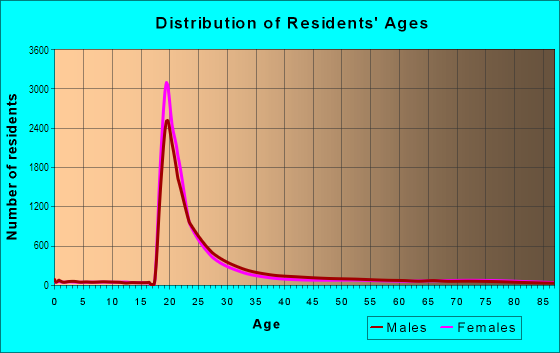
| Males: | 8,800 |
| Females: | 13,118 |
Males:
| This neighborhood: | 25.1 years |
| Whole city: | 32.7 years |
| This neighborhood: | 26.3 years |
| Whole city: | 34.1 years |
Average household size:
| Fenway (Kenmore Square): | 1.7 people |
| Boston: | 2.1 people |
Percentage of family households:
| Fenway (Kenmore Square): | 13.5% |
| Boston: | 34.5% |
| Here: | 10.4% |
| Boston: | 26.9% |
Percentage of married-couple families with children (among all households):
| Fenway (Kenmore Square): | 8.9% |
| Boston: | 24.9% |
Percentage of single-mother households (among all households):
| Fenway (Kenmore Square): | 292.7% |
| Boston: | 15.7% |
Percentage of never married males 15 years old and over:
Percentage of never married females 15 years old and over:
| Fenway (Kenmore Square): | 37.3% |
| Boston: | 26.8% |
Percentage of never married females 15 years old and over:
| Fenway (Kenmore Square): | 56.3% |
| city: | 28.3% |
Percentage of people that speak English not well or not at all:
| Fenway (Kenmore Square): | 1.1% |
| Boston: | 8.0% |
Percentage of people born in this state:
Percentage of people born in another U.S. state:
Percentage of native residents but born outside the U.S.:
Percentage of foreign born residents:
| Here: | 30.6% |
| Boston: | 42.4% |
Percentage of people born in another U.S. state:
| Fenway (Kenmore Square): | 45.2% |
| Boston: | 26.6% |
Percentage of native residents but born outside the U.S.:
| Here: | 2.0% |
| city: | 3.3% |
Percentage of foreign born residents:
| Here: | 22.2% |
| Boston: | 27.6% |

Owner-occupied
Renter-occupied


- Rooms in owner-occupied houses and condos in Fenway <
> - 441 room
- 682 rooms
- 8523 rooms
- 1584 rooms
- 4845 rooms
- 9056 rooms
- 7567 rooms
- 4178 rooms
- 7559+ rooms

- Rooms in renter-occupied apartments in Fenway <
> - 6981 room
- 4152 rooms
- 6933 rooms
- 6744 rooms
- 3335 rooms
- 756 rooms
- 357 rooms
- 3828 rooms
- 2319+ rooms
Owner-occupied
Renter-occupied

- Bedrooms in owner-occupied houses and condos in Fenway <
> - 44no bedroom
- 851 bedroom
- 6052 bedrooms
- 1853 bedrooms
- 8854 bedrooms
- 5795+ bedrooms

- Bedrooms in renter-occupied apartments in Fenway <
> - 809no bedroom
- 1,0321 bedroom
- 6482 bedrooms
- 4393 bedrooms
- 2024 bedrooms
- 2315+ bedrooms
Average number of cars or other vehicles available in houses/condos:
Average number of cars or other vehicles available in apartments:
| This neighborhood: | |
| Boston: |
Average number of cars or other vehicles available in apartments:
| Here: | 0.5 |
| city: | 0.7 |
Percentage of units with a mortgage:
| Fenway (Kenmore Square): | 29.0% |
| Boston: | 69.7% |

- Year house built in Fenway <
> - 5962020 or later
- 8,3252010 to 2019
- 4892000 to 2009
- 2691990 to 1999
- 1581980 to 1989
- 1731970 to 1979
- 1641960 to 1969
- 1631950 to 1959
- 5831940 to 1949
- 1,3931939 or earlier

City-data.com crime index for city in 2020 (higher means more crime):
| City: | 258.2 |
| U.S. average: | 219.5 |
Travel time to work (commute)
![Travel time to work (commute)]()
- 515Less than 5 minutes
- 2,1155 to 9 minutes
- 1,46210 to 14 minutes
- 1,46615 to 19 minutes
- 99520 to 24 minutes
- 31225 to 29 minutes
- 1,23330 to 34 minutes
- 21435 to 39 minutes
- 14740 to 44 minutes
- 21245 to 59 minutes
- 45560 to 89 minutes
- 10090 or more minutes

Means of transportation to work
![Means of transportation to work]()
- 8.8%866Drove a car alone
- 3.5%351Carpooled
- 3.8%377Bus
- 6.6%656Subway or elevated rail
- 2.6%254Long-distance train or commuter rail
- 2.0%201Light rail, streetcar or trolley
- 1.7%173Taxi
- 2.2%219Bicycle
- 58.9%5,823Walked
- 1.1%107Other means
- 15.9%1,576Worked at home

Time leaving home to go to work
![Time leaving home to go to work]()
- 11612:00 a.m. to 4:59 a.m.
- 1445:00 a.m. to 5:29 a.m.
- 2885:30 a.m. to 5:59 a.m.
- 1856:00 a.m. to 6:29 a.m.
- 2116:30 a.m. to 6:59 a.m.
- 7227:00 a.m. to 7:29 a.m.
- 7937:30 a.m. to 7:59 a.m.
- 1,0988:00 a.m. to 8:29 a.m.
- 8618:30 a.m. to 8:59 a.m.
- 1,3469:00 a.m. to 9:59 a.m.
- 42510:00 a.m. to 10:59 a.m.
- 80511:00 a.m. to 11:59 a.m.
- 1,32912:00 p.m. to 3:59 p.m.
- 1,2834:00 p.m. to 11:59 p.m.

Occupations of males:
- Percentage of males in management occupations (except farmers):
Here: 7.0% city: 12.7%
- Percentage of males in business and financial operations occupations:
Here: 7.4% city: 9.1%
- Percentage of males in computer and mathematical occupations:
Here: 5.9% city: 7.4%
- Percentage of males in architecture and engineering occupations:
Here: 1.1% city: 3.1%
- Percentage of males in life, physical, and social science occupations:
Here: 8.0% city: 3.9%
- Percentage of males in legal occupations:
Here: 1.5% city: 2.5%
- Percentage of males in education, training, and library occupations:
Here: 4.9% city: 5.7%
- Percentage of males in arts, design, entertainment, sports, and media occupations:
Here: 5.7% city: 2.7%
- Percentage of males in healthcare practitioners and technical occupations:
Here: 5.1% city: 4.4%
- Percentage of males in service occupations:
Here: 25.8% city: 16.0%
- Percentage of males in sales and office occupations:
Here: 25.0% city: 15.2%
- Percentage of males in transportation occupations:
Here: 1.2% city: 4.7%
Occupations of females:
- Percentage of females in management occupations (except farmers):
Here: 7.5% city: 12.2%
- Percentage of females in business and financial operations occupations:
Here: 5.1% city: 9.5%
- Percentage of females in computer and mathematical occupations:
Here: 3.5% city: 3.2%
- Percentage of females in architecture and engineering occupations:
Here: 2.1% city: 1.0%
- Percentage of females in life, physical, and social science occupations:
Here: 3.3% city: 3.3%
- Percentage of females in legal occupations:
Here: 1.5% city: 2.3%
- Percentage of females in education, training, and library occupations:
Here: 8.1% city: 9.4%
- Percentage of females in arts, design, entertainment, sports, and media occupations:
Here: 4.6% city: 3.4%
- Percentage of females in healthcare practitioners and technical occupations:
Here: 4.7% city: 10.2%
- Percentage of females in service occupations:
Here: 20.8% city: 18.6%
- Percentage of females in sales and office occupations:
Here: 36.0% city: 20.2%
- Percentage of females in material moving occupations:
Here: 1.4% city: 1.0%
Education in this neighborhood (subdivision or community):
- Percentage of people 3 years and older in K-12 schools:
Fenway (Kenmore Square): 36.7% Boston: 11.0%
- Percentage of people 3 years and older in undergraduate colleges:
Fenway (Kenmore Square): 77.3% Boston: 11.0%
- Percentage of people 3 years and older in grad. or professional schools:
Fenway (Kenmore Square): 8.4% Boston: 4.3%
- Percentage of students K-12 enrolled in private schools:
Fenway (Kenmore Square): 55.9% Boston: 13.8%
Percentage of population below poverty level:
| Fenway (Kenmore Square): | 32.0% |
| Boston: | 17.1% |
Percentage of married-couple families with both working:
| Fenway (Kenmore Square): | 374.2% |
| Boston: | 78.2% |

- 52.9%Electricity
- 37.8%Utility gas
- 2.7%Fuel oil, kerosene, etc.
- 2.5%No fuel used
- 1.5%Bottled, tank, or LP gas
- 1.4%Coal or coke
- 1.2%Other fuel
Highways in this neighborhood:
Commonwealth Ave (US Hwy 20)
Length: 0.27 miles
Direction: E-W
Direction: E-W
US Hwy 20 (Commonwealth Ave, Saint Marys St)
Length: 0.02 miles
Direction: E-W
Direction: E-W
Limited-access highways (interstate or state) in this neighborhood:
Massachusetts Tpke (I- 90)
Length: 1.82 miles
Directions: E-W, SE-NW
Directions: E-W, SE-NW
Highways in this neighborhood:
Huntington Ave (State Hwy 9)
Length: 3.41 miles
Directions: E-W, SW-NE
Directions: E-W, SW-NE
Commonwealth Ave (US Hwy 20)
Length: 2.39 miles
Direction: E-W
Address range: 430 to 558
Direction: E-W
Address range: 430 to 558
State Hwy 2 (Beacon St)
Length: 1.60 miles
Direction: E-W
Address range: 551 to 680
Direction: E-W
Address range: 551 to 680
Commonwealth Ave (Saint Marys St, US Hwy 20)
Length: 0.02 miles
Direction: E-W
Direction: E-W
Roads and streets:
Storrow Memorial Dr
Length: 1.92 miles
Directions: E-W, SW-NE
Directions: E-W, SW-NE
Park Dr
Length: 1.92 miles
Directions: E-W, N-S, SE-NW, SW-NE
Address range: 1 to 599
Directions: E-W, N-S, SE-NW, SW-NE
Address range: 1 to 599
Fenway
Length: 1.53 miles
Directions: E-W, N-S, SE-NW, SW-NE
Address range: 2 to 498
Directions: E-W, N-S, SE-NW, SW-NE
Address range: 2 to 498
Riverway
Length: 1.45 miles
Directions: E-W, N-S, SE-NW, SW-NE
Address range: 1 to 322
Directions: E-W, N-S, SE-NW, SW-NE
Address range: 1 to 322
Boylston St
Length: 1.25 miles
Directions: E-W, N-S, SE-NW, SW-NE
Address range: 1064 to 1499
Directions: E-W, N-S, SE-NW, SW-NE
Address range: 1064 to 1499
Bay State Rd
Length: 1.23 miles
Directions: E-W, SE-NW
Address range: 1 to 297
Directions: E-W, SE-NW
Address range: 1 to 297
Brookline Ave
Length: 1.14 miles
Direction: SW-NE
Address range: 1 to 466
Direction: SW-NE
Address range: 1 to 466
Longwood Ave
Length: 0.79 miles
Directions: E-W, SE-NW
Address range: 1 to 499
Directions: E-W, SE-NW
Address range: 1 to 499
Back St
Length: 0.63 miles
Directions: E-W, SW-NE
Directions: E-W, SW-NE
Hemenway St
Length: 0.57 miles
Directions: N-S, SW-NE
Address range: 1 to 298
Directions: N-S, SW-NE
Address range: 1 to 298
Ipswich St
Length: 0.57 miles
Directions: E-W, N-S, SE-NW, SW-NE
Address range: 1 to 298
Directions: E-W, N-S, SE-NW, SW-NE
Address range: 1 to 298
Gainsborough St
Length: 0.53 miles
Directions: E-W, SE-NW, SW-NE
Address range: 1 to 199
Directions: E-W, SE-NW, SW-NE
Address range: 1 to 199
Peterborough St
Length: 0.52 miles
Directions: E-W, SW-NE
Address range: 1 to 199
Directions: E-W, SW-NE
Address range: 1 to 199
Massachusetts Ave
Length: 0.48 miles
Directions: N-S, SE-NW
Address range: 117 to 404
Directions: N-S, SE-NW
Address range: 117 to 404
Queensberry St
Length: 0.46 miles
Direction: E-W
Address range: 1 to 199
Direction: E-W
Address range: 1 to 199
Ave of the Arts
Length: 0.42 miles
Direction: SW-NE
Direction: SW-NE
Norway St
Length: 0.40 miles
Directions: E-W, SE-NW, SW-NE
Address range: 1 to 199
Directions: E-W, SE-NW, SW-NE
Address range: 1 to 199
Ruggles St
Length: 0.39 miles
Directions: E-W, SE-NW
Address range: 228 to 391
Directions: E-W, SE-NW
Address range: 228 to 391
Westland Ave
Length: 0.38 miles
Directions: E-W, N-S, SE-NW, SW-NE
Address range: 1 to 198
Directions: E-W, N-S, SE-NW, SW-NE
Address range: 1 to 198
Forsyth St
Length: 0.38 miles
Directions: N-S, SE-NW, SW-NE
Address range: 6 to 199
Directions: N-S, SE-NW, SW-NE
Address range: 6 to 199
Jersey St
Length: 0.38 miles
Direction: SE-NW
Address range: 1 to 199
Direction: SE-NW
Address range: 1 to 199
Cummington St
Length: 0.37 miles
Directions: E-W, N-S
Address range: 1 to 199
Directions: E-W, N-S
Address range: 1 to 199
Evans Way
Length: 0.36 miles
Directions: E-W, N-S, SE-NW, SW-NE
Address range: 1 to 99
Directions: E-W, N-S, SE-NW, SW-NE
Address range: 1 to 99
Pilgrim Rd
Length: 0.36 miles
Directions: E-W, SW-NE
Address range: 1 to 99
Directions: E-W, SW-NE
Address range: 1 to 99
Van Ness St
Length: 0.33 miles
Direction: E-W
Address range: 1 to 99
Direction: E-W
Address range: 1 to 99
Newbury St
Length: 0.32 miles
Directions: E-W, SE-NW
Address range: 473 to 699
Directions: E-W, SE-NW
Address range: 473 to 699
Kilmarnock St
Length: 0.31 miles
Directions: N-S, SE-NW
Address range: 1 to 199
Directions: N-S, SE-NW
Address range: 1 to 199
Parker St
Length: 0.30 miles
Direction: SW-NE
Address range: 400 to 579
Direction: SW-NE
Address range: 400 to 579
St Stephen St
Length: 0.30 miles
Directions: E-W, SW-NE
Address range: 1 to 199
Directions: E-W, SW-NE
Address range: 1 to 199
Ave Louis Pasteur
Length: 0.29 miles
Directions: E-W, SW-NE
Address range: 1 to 199
Directions: E-W, SW-NE
Address range: 1 to 199
Mountfort St
Length: 0.29 miles
Directions: E-W, N-S, SE-NW
Address range: 1 to 123
Directions: E-W, N-S, SE-NW
Address range: 1 to 123
Saint Alphonsus St
Length: 0.29 miles
Directions: SE-NW, SW-NE
Address range: 1 to 127
Directions: SE-NW, SW-NE
Address range: 1 to 127
Lansdowne St (Ted Williams Way)
Length: 0.29 miles
Direction: E-W
Address range: 1 to 99
Direction: E-W
Address range: 1 to 99
St Botolph St
Length: 0.28 miles
Directions: E-W, SW-NE
Address range: 211 to 299
Directions: E-W, SW-NE
Address range: 211 to 299
Symphony Rd
Length: 0.25 miles
Direction: E-W
Address range: 1 to 99
Direction: E-W
Address range: 1 to 99
Charlesgate
Length: 0.25 miles
Directions: E-W, N-S, SW-NE
Address range: 1 to 6
Directions: E-W, N-S, SW-NE
Address range: 1 to 6
Palace Rd
Length: 0.24 miles
Direction: SW-NE
Address range: 1 to 199
Direction: SW-NE
Address range: 1 to 199
Edgerly Rd
Length: 0.23 miles
Directions: N-S, SE-NW
Address range: 1 to 99
Directions: N-S, SE-NW
Address range: 1 to 99
Agassiz Rd
Length: 0.22 miles
Direction: E-W
Address range: 1 to 99
Direction: E-W
Address range: 1 to 99
St Germain St
Length: 0.20 miles
Direction: E-W
Address range: 1 to 99
Direction: E-W
Address range: 1 to 99
Binney St
Length: 0.20 miles
Direction: SW-NE
Address range: 23 to 99
Direction: SW-NE
Address range: 23 to 99
Annunciation Rd
Length: 0.20 miles
Directions: E-W, SW-NE
Address range: 1 to 264
Directions: E-W, SW-NE
Address range: 1 to 264
Field St
Length: 0.19 miles
Directions: E-W, N-S, SE-NW, SW-NE
Address range: 1 to 99
Directions: E-W, N-S, SE-NW, SW-NE
Address range: 1 to 99
Burbank St
Length: 0.18 miles
Directions: E-W, SE-NW
Address range: 1 to 99
Directions: E-W, SE-NW
Address range: 1 to 99
Clearway St
Length: 0.17 miles
Direction: E-W
Address range: 1 to 99
Direction: E-W
Address range: 1 to 99
Leon St
Length: 0.17 miles
Direction: N-S
Address range: 1 to 99
Direction: N-S
Address range: 1 to 99
Deaconess Rd
Length: 0.17 miles
Direction: SE-NW
Address range: 1 to 99
Direction: SE-NW
Address range: 1 to 99
Charlesgate W
Length: 0.17 miles
Direction: N-S
Address range: 7 to 78
Direction: N-S
Address range: 7 to 78
Fullerton St
Length: 0.16 miles
Direction: SE-NW
Direction: SE-NW
Museum Rd
Length: 0.16 miles
Directions: E-W, SE-NW
Address range: 1 to 99
Directions: E-W, SE-NW
Address range: 1 to 99
Shattuck St
Length: 0.16 miles
Directions: E-W, SE-NW
Address range: 1 to 99
Directions: E-W, SE-NW
Address range: 1 to 99
Greenleaf St
Length: 0.16 miles
Directions: E-W, SE-NW
Address range: 1 to 99
Directions: E-W, SE-NW
Address range: 1 to 99
Overland St
Length: 0.15 miles
Directions: E-W, SE-NW
Address range: 1 to 99
Directions: E-W, SE-NW
Address range: 1 to 99
Forsyth
Length: 0.15 miles
Direction: SW-NE
Direction: SW-NE
Short St
Length: 0.15 miles
Direction: SE-NW
Address range: 1 to 8
Direction: SE-NW
Address range: 1 to 8
St Cecilia St
Length: 0.14 miles
Directions: E-W, N-S
Address range: 7 to 41
Directions: E-W, N-S
Address range: 7 to 41
Haviland St
Length: 0.13 miles
Direction: E-W
Address range: 1 to 99
Direction: E-W
Address range: 1 to 99
Hemenway Ter
Length: 0.13 miles
Directions: E-W, N-S, SE-NW
Directions: E-W, N-S, SE-NW
Buswell St
Length: 0.13 miles
Direction: E-W
Address range: 1 to 24
Direction: E-W
Address range: 1 to 24
Plymouth St
Length: 0.13 miles
Directions: E-W, N-S, SE-NW, SW-NE
Address range: 1 to 99
Directions: E-W, N-S, SE-NW, SW-NE
Address range: 1 to 99
Burlington Ave
Length: 0.13 miles
Direction: SE-NW
Address range: 1 to 99
Direction: SE-NW
Address range: 1 to 99
Blackfan St
Length: 0.12 miles
Direction: SW-NE
Address range: 1 to 99
Direction: SW-NE
Address range: 1 to 99
Deerfield St
Length: 0.12 miles
Directions: N-S, SE-NW
Address range: 1 to 99
Directions: N-S, SE-NW
Address range: 1 to 99
N389
Length: 0.12 miles
Directions: E-W, SE-NW, SW-NE
Directions: E-W, SE-NW, SW-NE
Speare Pl
Length: 0.12 miles
Direction: E-W
Address range: 1 to 13
Direction: E-W
Address range: 1 to 13
Tavern Rd
Length: 0.12 miles
Direction: SW-NE
Address range: 1 to 99
Direction: SW-NE
Address range: 1 to 99
Autumn St
Length: 0.12 miles
Directions: E-W, N-S, SE-NW, SW-NE
Address range: 1 to 99
Directions: E-W, N-S, SE-NW, SW-NE
Address range: 1 to 99
Louis Prang St
Length: 0.12 miles
Direction: SE-NW
Address range: 1 to 99
Direction: SE-NW
Address range: 1 to 99
Dalton St
Length: 0.11 miles
Directions: N-S, SE-NW, SW-NE
Address range: 1 to 24
Directions: N-S, SE-NW, SW-NE
Address range: 1 to 24
Stoneholm St
Length: 0.11 miles
Directions: E-W, N-S, SW-NE
Address range: 1 to 99
Directions: E-W, N-S, SW-NE
Address range: 1 to 99
Scotia St
Length: 0.11 miles
Direction: E-W
Address range: 1 to 99
Direction: E-W
Address range: 1 to 99
Sherborn St
Length: 0.10 miles
Direction: N-S
Address range: 1 to 99
Direction: N-S
Address range: 1 to 99
Medfield St
Length: 0.09 miles
Direction: E-W
Address range: 1 to 60
Direction: E-W
Address range: 1 to 60
Kenmore St
Length: 0.09 miles
Direction: N-S
Address range: 1 to 99
Direction: N-S
Address range: 1 to 99
Maitland St
Length: 0.09 miles
Directions: SE-NW, SW-NE
Directions: SE-NW, SW-NE
Granby St
Length: 0.09 miles
Direction: N-S
Address range: 1 to 99
Direction: N-S
Address range: 1 to 99
Fenway St
Length: 0.09 miles
Directions: E-W, SW-NE
Directions: E-W, SW-NE
Blandford St
Length: 0.09 miles
Direction: N-S
Address range: 1 to 99
Direction: N-S
Address range: 1 to 99
Charlesgate E
Length: 0.09 miles
Directions: N-S, SE-NW
Address range: 50 to 99
Directions: N-S, SE-NW
Address range: 50 to 99
Cambria St
Length: 0.08 miles
Direction: E-W
Address range: 1 to 99
Direction: E-W
Address range: 1 to 99
Aberdeen St
Length: 0.08 miles
Direction: SE-NW
Address range: 9 to 99
Direction: SE-NW
Address range: 9 to 99
Raleigh St
Length: 0.08 miles
Directions: N-S, SE-NW
Address range: 1 to 99
Directions: N-S, SE-NW
Address range: 1 to 99
Miner St
Length: 0.08 miles
Direction: SE-NW
Address range: 11 to 99
Direction: SE-NW
Address range: 11 to 99
Fenway Plz
Length: 0.07 miles
Direction: SE-NW
Address range: 1 to 99
Direction: SE-NW
Address range: 1 to 99
Joslin Pl
Length: 0.07 miles
Direction: SE-NW
Address range: 1 to 99
Direction: SE-NW
Address range: 1 to 99
University Rd
Length: 0.07 miles
Direction: N-S
Direction: N-S
Children's Rd
Length: 0.06 miles
Direction: SE-NW
Direction: SE-NW
Hinsdale St
Length: 0.06 miles
Direction: N-S
Direction: N-S
Vancouver St
Length: 0.06 miles
Direction: SW-NE
Address range: 1 to 33
Direction: SW-NE
Address range: 1 to 33
Arundel St
Length: 0.06 miles
Direction: SE-NW
Address range: 1 to 99
Direction: SE-NW
Address range: 1 to 99
Keswick St
Length: 0.06 miles
Direction: SE-NW
Address range: 1 to 99
Direction: SE-NW
Address range: 1 to 99
Tetlow St
Length: 0.06 miles
Direction: E-W
Address range: 1 to 99
Direction: E-W
Address range: 1 to 99
Fencourt Rd
Length: 0.06 miles
Directions: E-W, SE-NW
Directions: E-W, SE-NW
Worthington St
Length: 0.06 miles
Direction: SW-NE
Address range: 51 to 99
Direction: SW-NE
Address range: 51 to 99
Claremont St
Length: 0.06 miles
Directions: E-W, SW-NE
Address range: 73 to 99
Directions: E-W, SW-NE
Address range: 73 to 99
New Edgerly Rd
Length: 0.05 miles
Direction: E-W
Address range: 48 to 114
Direction: E-W
Address range: 48 to 114
Albemarle Ter
Length: 0.05 miles
Directions: SE-NW, SW-NE
Address range: 1 to 99
Directions: SE-NW, SW-NE
Address range: 1 to 99
Jimmy Fund Way
Length: 0.05 miles
Direction: SE-NW
Address range: 1 to 99
Direction: SE-NW
Address range: 1 to 99
Opera Pl
Length: 0.05 miles
Direction: SE-NW
Address range: 1 to 99
Direction: SE-NW
Address range: 1 to 99
Smith St
Length: 0.05 miles
Direction: E-W
Address range: 124 to 199
Direction: E-W
Address range: 124 to 199
Whipple St
Length: 0.05 miles
Direction: N-S
Direction: N-S
Tremont St
Length: 0.05 miles
Direction: E-W
Address range: 1560 to 1572
Direction: E-W
Address range: 1560 to 1572
Bills Ct
Length: 0.05 miles
Direction: SW-NE
Direction: SW-NE
Munson St
Length: 0.05 miles
Direction: SE-NW
Address range: 17 to 99
Direction: SE-NW
Address range: 17 to 99
Belvidere St
Length: 0.05 miles
Direction: E-W
Address range: 1 to 10
Direction: E-W
Address range: 1 to 10
Albemarle St
Length: 0.04 miles
Direction: SE-NW
Address range: 23 to 99
Direction: SE-NW
Address range: 23 to 99
Ward St
Length: 0.04 miles
Direction: E-W
Address range: 170 to 199
Direction: E-W
Address range: 170 to 199
Forsyth Way
Length: 0.04 miles
Direction: N-S
Direction: N-S
Brookwood Ter
Length: 0.03 miles
Direction: SE-NW
Address range: 1 to 99
Direction: SE-NW
Address range: 1 to 99
Railroad features:
Mbta Commuter Rail (Amtrak RR)
Length: 1.36 miles
Direction: E-W
Direction: E-W
Mbta Orange Line RR (Mbta Commuter Rail, Amtrak RR)
Length: 0.65 miles
Directions: N-S, SW-NE
Directions: N-S, SW-NE
Mass transit rail lines:
Mbta Green Line Trolley
Length: 1.28 miles
Directions: E-W, SW-NE
Directions: E-W, SW-NE
Other features:
Muddy Riv
Length: 0.74 miles
Directions: E-W, N-S, SE-NW, SW-NE
Directions: E-W, N-S, SE-NW, SW-NE