Downtown Ashland (Downtown) neighborhood in Ashland, Ohio (OH), 44805 detailed profile
Settings
X


Business Search - 14 Million verified businesses
Area: 1.957 square miles
Population: 8,770
Population density:
| Downtown Ashland (Downtown): | 4,482 people per square mile |
| Ashland: | 1,860 people per square mile |

- 8,04883.5%White
- 4154.3%Hispanic or Latino
- 3894.0%Some other race
- 3874.0%Two or more races
- 2062.1%Black
- 1521.6%Asian
- 390.4%American Indian

Distribution of median household income
![Distribution of median household income]()
- 397Less than $10,000
- 612$10,000 to $19,999
- 464$20,000 to $29,999
- 510$30,000 to $39,999
- 460$40,000 to $49,999
- 294$50,000 to $59,999
- 345$60,000 to $74,999
- 499$75,000 to $99,999
- 257$100,000 to $124,999
- 183$125,000 to $149,999
- 164$150,000 to $199,999
- 181$200,000 or more

Distribution of owner-occupied house/condo value
![Distribution of owner-occupied house/condo value]()
- 789Less than $50,000
- 1,040$50,000 to $99,999
- 619$100,000 to $149,999
- 757$150,000 to $199,999
- 161$200,000 to $249,999
- 171$250,000 to $299,999
- 205$300,000 to $399,999
- 215$400,000 to $499,999
- 118$500,000 to $749,999
- 39$750,000 to $999,999
- 17$1,000,000 or more

Distribution of rent paid by renters
![Distribution of rent paid by renters]()
- 59$100 to $199
- 324$200 to $299
- 492$300 to $399
- 435$400 to $499
- 589$500 to $599
- 525$600 to $699
- 520$700 to $799
- 328$800 to $899
- 259$900 to $999
- 118$1,000 to $1,249
- 426$1,500 to $1,999
- 97$2,000 or more

| Males: | 4,075 |
| Females: | 4,695 |
Males:
| This neighborhood: | 35.9 years |
| Whole city: | 36.9 years |
| This neighborhood: | 39.0 years |
| Whole city: | 40.8 years |
Average household size:
| Downtown Ashland (Downtown): | 4.8 people |
| Ashland: | 2.2 people |
Percentage of family households:
| Downtown Ashland (Downtown): | 38.0% |
| Ashland: | 37.8% |
| Here: | 40.9% |
| Ashland: | 42.5% |
Percentage of married-couple families with children (among all households):
| Downtown Ashland (Downtown): | 34.1% |
| Ashland: | 30.7% |
Percentage of single-mother households (among all households):
| Downtown Ashland (Downtown): | 10.6% |
| Ashland: | 8.7% |
Percentage of never married males 15 years old and over:
Percentage of never married females 15 years old and over:
| Downtown Ashland (Downtown): | 20.4% |
| Ashland: | 18.2% |
Percentage of never married females 15 years old and over:
| Downtown Ashland (Downtown): | 22.5% |
| city: | 15.9% |
Percentage of people that speak English not well or not at all:
| Downtown Ashland (Downtown): | 0.1% |
| Ashland: | 0.1% |
Percentage of people born in this state:
Percentage of people born in another U.S. state:
Percentage of native residents but born outside the U.S.:
Percentage of foreign born residents:
| Here: | 83.1% |
| Ashland: | 83.4% |
Percentage of people born in another U.S. state:
| Downtown Ashland (Downtown): | 13.8% |
| Ashland: | 14.7% |
Percentage of native residents but born outside the U.S.:
| Here: | 0.2% |
| city: | 0.2% |
Percentage of foreign born residents:
| Here: | 3.0% |
| Ashland: | 1.7% |

Owner-occupied
Renter-occupied


- Rooms in owner-occupied houses and condos in Downtown Ashland <
> - 01 room
- 12 rooms
- 1293 rooms
- 1604 rooms
- 2715 rooms
- 4276 rooms
- 3407 rooms
- 3818 rooms
- 3739+ rooms
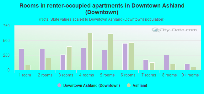
- Rooms in renter-occupied apartments in Downtown Ashland <
> - 3631 room
- 3542 rooms
- 2603 rooms
- 3764 rooms
- 3395 rooms
- 4526 rooms
- 1777 rooms
- 2568 rooms
- 1049+ rooms
Owner-occupied
Renter-occupied

- Bedrooms in owner-occupied houses and condos in Downtown Ashland <
> - 3no bedroom
- 661 bedroom
- 3822 bedrooms
- 9923 bedrooms
- 3394 bedrooms
- 1015+ bedrooms

- Bedrooms in renter-occupied apartments in Downtown Ashland <
> - 363no bedroom
- 5031 bedroom
- 6042 bedrooms
- 4573 bedrooms
- 3484 bedrooms
- 125+ bedrooms
Average number of cars or other vehicles available in houses/condos:
Average number of cars or other vehicles available in apartments:
| This neighborhood: | 2.0 |
| Ashland: | 1.9 |
Average number of cars or other vehicles available in apartments:
| Here: | 1.4 |
| city: | 1.3 |
Percentage of units with a mortgage:
| Downtown Ashland (Downtown): | 66.2% |
| Ashland: | 61.3% |
Average estimated value of detached houses in 2022 (60.3% of all units):
| Downtown Ashland (Downtown): | $168,480 |
| Ashland: | $145,354 |

- Year house built in Downtown Ashland <
> - 52020 or later
- 612010 to 2019
- 6862000 to 2009
- 5401990 to 1999
- 2141980 to 1989
- 5301970 to 1979
- 2921960 to 1969
- 4591950 to 1959
- 4061940 to 1949
- 1,5191939 or earlier

City-data.com crime index for city in 2020 (higher means more crime):
| City: | 126.7 |
| U.S. average: | 219.5 |
Travel time to work (commute)
![Travel time to work (commute)]()
- 285Less than 5 minutes
- 1,3985 to 9 minutes
- 72210 to 14 minutes
- 18715 to 19 minutes
- 30220 to 24 minutes
- 5525 to 29 minutes
- 35930 to 34 minutes
- 8935 to 39 minutes
- 5340 to 44 minutes
- 13545 to 59 minutes
- 17860 to 89 minutes
- 3990 or more minutes

Means of transportation to work
![Means of transportation to work]()
- 72.2%3,117Drove a car alone
- 10.6%456Carpooled
- 0.7%29Bus
- 1.7%75Taxi
- 0.1%5Motorcycle
- 10.1%436Bicycle
- 13.3%574Walked
- 0.2%9Other means
- 12.4%533Worked at home

Time leaving home to go to work
![Time leaving home to go to work]()
- 15412:00 a.m. to 4:59 a.m.
- 225:00 a.m. to 5:29 a.m.
- 1985:30 a.m. to 5:59 a.m.
- 1706:00 a.m. to 6:29 a.m.
- 4446:30 a.m. to 6:59 a.m.
- 3317:00 a.m. to 7:29 a.m.
- 7227:30 a.m. to 7:59 a.m.
- 2388:00 a.m. to 8:29 a.m.
- 2718:30 a.m. to 8:59 a.m.
- 1889:00 a.m. to 9:59 a.m.
- 11610:00 a.m. to 10:59 a.m.
- 9411:00 a.m. to 11:59 a.m.
- 46812:00 p.m. to 3:59 p.m.
- 4134:00 p.m. to 11:59 p.m.

Occupations of males:
- Percentage of males in management occupations (except farmers):
Here: 6.7% city: 4.8%
- Percentage of males in business and financial operations occupations:
Here: 5.6% city: 5.0%
- Percentage of males in computer and mathematical occupations:
Here: 3.6% city: 4.9%
- Percentage of males in architecture and engineering occupations:
Here: 3.1% city: 1.5%
- Percentage of males in community and social services occupations:
Here: 2.3% city: 2.7%
- Percentage of males in education, training, and library occupations:
Here: 2.3% city: 3.4%
- Percentage of males in arts, design, entertainment, sports, and media occupations:
Here: 1.6% city: 1.3%
- Percentage of males in healthcare practitioners and technical occupations:
Here: 2.9% city: 3.5%
- Percentage of males in service occupations:
Here: 12.1% city: 11.8%
- Percentage of males in sales and office occupations:
Here: 19.4% city: 17.1%
- Percentage of males in construction, extraction, and maintenance occupations:
Here: 4.0% city: 4.3%
- Percentage of males in production occupations:
Here: 11.3% city: 18.1%
- Percentage of males in transportation occupations:
Here: 7.2% city: 7.4%
- Percentage of males in material moving occupations:
Here: 12.3% city: 8.7%
Occupations of females:
- Percentage of females in management occupations (except farmers):
Here: 3.4% city: 6.1%
- Percentage of females in business and financial operations occupations:
Here: 8.0% city: 7.5%
- Percentage of females in computer and mathematical occupations:
Here: 1.0% city: 0.7%
- Percentage of females in life, physical, and social science occupations:
Here: 2.1% city: 1.3%
- Percentage of females in community and social services occupations:
Here: 2.1% city: 3.9%
- Percentage of females in education, training, and library occupations:
Here: 10.1% city: 8.7%
- Percentage of females in arts, design, entertainment, sports, and media occupations:
Here: 1.8% city: 1.0%
- Percentage of females in healthcare practitioners and technical occupations:
Here: 3.0% city: 6.1%
- Percentage of females in service occupations:
Here: 23.4% city: 19.0%
- Percentage of females in sales and office occupations:
Here: 34.2% city: 31.3%
- Percentage of females in production occupations:
Here: 5.7% city: 7.4%
- Percentage of females in transportation occupations:
Here: 1.2% city: 1.4%
- Percentage of females in material moving occupations:
Here: 3.3% city: 4.4%
Percentage of people 16-64 in Armed Forces:
| Downtown Ashland (Downtown): | 0.3% |
| Ashland: | 0.1% |
Education in this neighborhood (subdivision or community):
- Percentage of people 3 years and older in K-12 schools:
Downtown Ashland (Downtown): 22.2% Ashland: 15.9%
- Percentage of people 3 years and older in undergraduate colleges:
Downtown Ashland (Downtown): 20.4% Ashland: 8.9%
- Percentage of people 3 years and older in grad. or professional schools:
Downtown Ashland (Downtown): 2.7% Ashland: 0.7%
- Percentage of students K-12 enrolled in private schools:
Downtown Ashland (Downtown): 34.3% Ashland: 8.3%
Percentage of population below poverty level:
| Downtown Ashland (Downtown): | 18.3% |
| Ashland: | 13.9% |
Median year owner moved in (as recorded in 2022):
| Downtown Ashland (Downtown): | 2006 |
| Ashland: | 2008 |
Percentage of married-couple families with both working:
| Downtown Ashland (Downtown): | 124.5% |
| Ashland: | 74.5% |

- 61.7%Utility gas
- 16.9%Electricity
- 9.1%Fuel oil, kerosene, etc.
- 4.5%Bottled, tank, or LP gas
- 4.1%Wood
- 1.9%Other fuel
- 1.9%No fuel used
Highways in this neighborhood:
E Main St (US Hwy 250)
Length: 1.32 miles
Direction: E-W
Address range: 1 to 1099
Direction: E-W
Address range: 1 to 1099
State Rte 60 (State Rte 511, Center St)
Length: 0.95 miles
Directions: N-S, SE-NW
Address range: 140 to 1123
Directions: N-S, SE-NW
Address range: 140 to 1123
Sandusky St (State Rte 96)
Length: 0.49 miles
Directions: E-W, SE-NW
Address range: 200 to 614
Directions: E-W, SE-NW
Address range: 200 to 614
S Cottage St (State Rte 511, US Hwy 250, State Rte 60)
Length: 0.32 miles
Directions: N-S, SE-NW
Address range: 100 to 659
Directions: N-S, SE-NW
Address range: 100 to 659
State Rte 58 (Union St)
Length: 0.31 miles
Direction: N-S
Address range: 100 to 705
Direction: N-S
Address range: 100 to 705
Roads and streets:
Smith Rd
Length: 1.23 miles
Direction: E-W
Address range: 618 to 1256
Direction: E-W
Address range: 618 to 1256
Claremont Ave
Length: 1.20 miles
Directions: E-W, N-S, SW-NE
Address range: 120 to 1199
Directions: E-W, N-S, SW-NE
Address range: 120 to 1199
Co Rd 42B (Cleveland Ave)
Length: 1.18 miles
Direction: E-W
Address range: 220 to 1099
Direction: E-W
Address range: 220 to 1099
Broad St
Length: 1.16 miles
Directions: E-W, SW-NE
Address range: 100 to 1299
Directions: E-W, SW-NE
Address range: 100 to 1299
Hillcrest Dr
Length: 0.96 miles
Direction: E-W
Address range: 300 to 1099
Direction: E-W
Address range: 300 to 1099
E 7th St
Length: 0.84 miles
Direction: E-W
Address range: 1 to 998
Direction: E-W
Address range: 1 to 998
Samaritan Ave
Length: 0.80 miles
Direction: E-W
Address range: 1 to 526
Direction: E-W
Address range: 1 to 526
E 4th St
Length: 0.72 miles
Direction: E-W
Address range: 51 to 470
Direction: E-W
Address range: 51 to 470
E Liberty St
Length: 0.72 miles
Direction: E-W
Address range: 100 to 559
Direction: E-W
Address range: 100 to 559
E 8th St
Length: 0.71 miles
Directions: E-W, SW-NE
Address range: 300 to 799
Directions: E-W, SW-NE
Address range: 300 to 799
College Ave
Length: 0.70 miles
Direction: E-W
Address range: 1 to 599
Direction: E-W
Address range: 1 to 599
W Walnut St
Length: 0.68 miles
Directions: E-W, SE-NW
Address range: 100 to 651
Directions: E-W, SE-NW
Address range: 100 to 651
Eastern Ave
Length: 0.67 miles
Direction: N-S
Address range: 401 to 898
Direction: N-S
Address range: 401 to 898
Ashland Ave
Length: 0.61 miles
Directions: E-W, N-S, SW-NE
Address range: 117 to 739
Directions: E-W, N-S, SW-NE
Address range: 117 to 739
Commercial Ave
Length: 0.61 miles
Direction: E-W
Address range: 1 to 299
Direction: E-W
Address range: 1 to 299
Park St
Length: 0.58 miles
Directions: N-S, SE-NW
Address range: 400 to 1198
Directions: N-S, SE-NW
Address range: 400 to 1198
W Main St
Length: 0.58 miles
Direction: E-W
Address range: 1 to 607
Direction: E-W
Address range: 1 to 607
E Walnut St
Length: 0.58 miles
Direction: E-W
Address range: 2 to 465
Direction: E-W
Address range: 2 to 465
W Liberty St
Length: 0.58 miles
Directions: E-W, SE-NW
Address range: 200 to 541
Directions: E-W, SE-NW
Address range: 200 to 541
Sherman Ave
Length: 0.58 miles
Direction: N-S
Address range: 101 to 639
Direction: N-S
Address range: 101 to 639
Edgehill Ave
Length: 0.55 miles
Direction: N-S
Address range: 400 to 1198
Direction: N-S
Address range: 400 to 1198
Morgan Ave
Length: 0.54 miles
Directions: E-W, N-S, SE-NW
Address range: 1 to 251
Directions: E-W, N-S, SE-NW
Address range: 1 to 251
Grant St
Length: 0.51 miles
Direction: N-S
Address range: 500 to 1141
Direction: N-S
Address range: 500 to 1141
Steele Ave
Length: 0.51 miles
Direction: N-S
Address range: 117 to 531
Direction: N-S
Address range: 117 to 531
Chestnut St
Length: 0.50 miles
Direction: N-S
Address range: 501 to 1124
Direction: N-S
Address range: 501 to 1124
Thomas Dr
Length: 0.48 miles
Directions: N-S, SW-NE
Address range: 900 to 1199
Directions: N-S, SW-NE
Address range: 900 to 1199
Elmarna Ave
Length: 0.48 miles
Directions: E-W, N-S, SE-NW
Address range: 1019 to 1099
Directions: E-W, N-S, SE-NW
Address range: 1019 to 1099
Pleasant St
Length: 0.48 miles
Direction: E-W
Address range: 147 to 542
Direction: E-W
Address range: 147 to 542
E 3rd St
Length: 0.47 miles
Direction: E-W
Address range: 1 to 399
Direction: E-W
Address range: 1 to 399
W 4th St
Length: 0.45 miles
Direction: E-W
Address range: 1 to 398
Direction: E-W
Address range: 1 to 398
E Washington St
Length: 0.45 miles
Direction: E-W
Address range: 100 to 323
Direction: E-W
Address range: 100 to 323
Mifflin Ave
Length: 0.43 miles
Directions: E-W, N-S, SE-NW, SW-NE
Address range: 1028 to 1198
Directions: E-W, N-S, SE-NW, SW-NE
Address range: 1028 to 1198
Laurel Ave
Length: 0.42 miles
Direction: SE-NW
Address range: 800 to 1008
Direction: SE-NW
Address range: 800 to 1008
Vernon Ave
Length: 0.40 miles
Directions: E-W, N-S, SE-NW, SW-NE
Address range: 2 to 144
Directions: E-W, N-S, SE-NW, SW-NE
Address range: 2 to 144
High St
Length: 0.40 miles
Direction: E-W
Address range: 1 to 245
Direction: E-W
Address range: 1 to 245
Hale Ave
Length: 0.40 miles
Direction: N-S
Address range: 684 to 1123
Direction: N-S
Address range: 684 to 1123
E 5th St
Length: 0.38 miles
Direction: E-W
Address range: 500 to 621
Direction: E-W
Address range: 500 to 621
E Bank St
Length: 0.38 miles
Directions: E-W, SW-NE
Address range: 1 to 1099
Directions: E-W, SW-NE
Address range: 1 to 1099
Maple St
Length: 0.37 miles
Direction: E-W
Address range: 100 to 299
Direction: E-W
Address range: 100 to 299
Arthur St
Length: 0.37 miles
Directions: N-S, SE-NW
Address range: 134 to 649
Directions: N-S, SE-NW
Address range: 134 to 649
Hoover Dr
Length: 0.37 miles
Direction: E-W
Address range: 800 to 1026
Direction: E-W
Address range: 800 to 1026
Moss Hill Dr
Length: 0.37 miles
Directions: E-W, SE-NW, SW-NE
Address range: 830 to 973
Directions: E-W, SE-NW, SW-NE
Address range: 830 to 973
W Washington St
Length: 0.35 miles
Directions: E-W, SE-NW
Address range: 100 to 343
Directions: E-W, SE-NW
Address range: 100 to 343
Lincoln Ave
Length: 0.34 miles
Direction: N-S
Address range: 118 to 267
Direction: N-S
Address range: 118 to 267
Bank St
Length: 0.34 miles
Direction: E-W
Address range: 417 to 567
Direction: E-W
Address range: 417 to 567
Diamond St
Length: 0.33 miles
Direction: E-W
Address range: 200 to 499
Direction: E-W
Address range: 200 to 499
Miller St
Length: 0.33 miles
Direction: N-S
Address range: 200 to 613
Direction: N-S
Address range: 200 to 613
W 3rd St
Length: 0.32 miles
Directions: E-W, N-S, SE-NW
Address range: 200 to 399
Directions: E-W, N-S, SE-NW
Address range: 200 to 399
King Rd
Length: 0.32 miles
Direction: N-S
Address range: 1000 to 1199
Direction: N-S
Address range: 1000 to 1199
Garmon St
Length: 0.31 miles
Directions: E-W, N-S, SW-NE
Address range: 614 to 776
Directions: E-W, N-S, SW-NE
Address range: 614 to 776
Highland Blvd
Length: 0.31 miles
Direction: E-W
Address range: 2 to 253
Direction: E-W
Address range: 2 to 253
Orange St
Length: 0.31 miles
Direction: N-S
Address range: 300 to 699
Direction: N-S
Address range: 300 to 699
Ferrell Ave
Length: 0.29 miles
Direction: E-W
Address range: 1 to 326
Direction: E-W
Address range: 1 to 326
Duff Dr
Length: 0.28 miles
Direction: E-W
Address range: 800 to 926
Direction: E-W
Address range: 800 to 926
Evergreen St
Length: 0.28 miles
Direction: E-W
Address range: 500 to 627
Direction: E-W
Address range: 500 to 627
Luray Dr
Length: 0.27 miles
Direction: N-S
Address range: 800 to 1134
Direction: N-S
Address range: 800 to 1134
Jackson Dr
Length: 0.27 miles
Direction: N-S
Direction: N-S
Church St
Length: 0.27 miles
Direction: N-S
Address range: 100 to 699
Direction: N-S
Address range: 100 to 699
College Blvd
Length: 0.27 miles
Direction: N-S
Address range: 800 to 1199
Direction: N-S
Address range: 800 to 1199
Marlo Ave
Length: 0.26 miles
Direction: E-W
Address range: 601 to 634
Direction: E-W
Address range: 601 to 634
Quarry St
Length: 0.26 miles
Direction: E-W
Address range: 300 to 417
Direction: E-W
Address range: 300 to 417
Ronald Ave
Length: 0.25 miles
Directions: E-W, N-S, SE-NW
Address range: 114 to 299
Directions: E-W, N-S, SE-NW
Address range: 114 to 299
Oak Hill Cir
Length: 0.24 miles
Directions: E-W, N-S, SE-NW, SW-NE
Address range: 1000 to 1098
Directions: E-W, N-S, SE-NW, SW-NE
Address range: 1000 to 1098
Jacobs St
Length: 0.24 miles
Direction: SE-NW
Direction: SE-NW
Holbrook St
Length: 0.23 miles
Direction: N-S
Address range: 200 to 206
Direction: N-S
Address range: 200 to 206
Mathews Ave
Length: 0.23 miles
Directions: E-W, N-S, SW-NE
Address range: 121 to 267
Directions: E-W, N-S, SW-NE
Address range: 121 to 267
Bruce St
Length: 0.23 miles
Direction: E-W
Address range: 600 to 741
Direction: E-W
Address range: 600 to 741
Westview Ave
Length: 0.23 miles
Direction: SW-NE
Address range: 1024 to 2299
Direction: SW-NE
Address range: 1024 to 2299
Taylor St
Length: 0.23 miles
Directions: N-S, SE-NW
Address range: 200 to 529
Directions: N-S, SE-NW
Address range: 200 to 529
Buckeye St
Length: 0.22 miles
Direction: N-S
Address range: 400 to 727
Direction: N-S
Address range: 400 to 727
Banning Ave
Length: 0.21 miles
Direction: E-W
Address range: 101 to 299
Direction: E-W
Address range: 101 to 299
South St W (W South St)
Length: 0.21 miles
Direction: E-W
Address range: 1 to 499
Direction: E-W
Address range: 1 to 499
Mount Auburn Ave
Length: 0.20 miles
Direction: N-S
Address range: 900 to 1117
Direction: N-S
Address range: 900 to 1117
Virginia Ave
Length: 0.20 miles
Direction: N-S
Address range: 300 to 699
Direction: N-S
Address range: 300 to 699
Luther St
Length: 0.20 miles
Direction: N-S
Address range: 100 to 499
Direction: N-S
Address range: 100 to 499
Sloan Ave
Length: 0.20 miles
Direction: N-S
Address range: 300 to 599
Direction: N-S
Address range: 300 to 599
Pearl St
Length: 0.19 miles
Direction: E-W
Address range: 120 to 247
Direction: E-W
Address range: 120 to 247
Losier Ct
Length: 0.19 miles
Direction: E-W
Direction: E-W
E 2nd St
Length: 0.18 miles
Direction: E-W
Address range: 1 to 199
Direction: E-W
Address range: 1 to 199
Cherry Ave
Length: 0.18 miles
Direction: E-W
Address range: 500 to 563
Direction: E-W
Address range: 500 to 563
Hofer Dr
Length: 0.17 miles
Direction: E-W
Direction: E-W
Olympic Cir
Length: 0.17 miles
Directions: E-W, N-S, SE-NW, SW-NE
Address range: 436 to 650
Directions: E-W, N-S, SE-NW, SW-NE
Address range: 436 to 650
Rubber St
Length: 0.17 miles
Direction: E-W
Direction: E-W
W 2nd St
Length: 0.16 miles
Direction: E-W
Address range: 1 to 199
Direction: E-W
Address range: 1 to 199
Markley Ave
Length: 0.16 miles
Direction: E-W
Address range: 413 to 454
Direction: E-W
Address range: 413 to 454
Forestdale Rd
Length: 0.16 miles
Direction: E-W
Address range: 400 to 459
Direction: E-W
Address range: 400 to 459
Parkwood Dr
Length: 0.16 miles
Direction: E-W
Address range: 400 to 461
Direction: E-W
Address range: 400 to 461
Downs Ct
Length: 0.16 miles
Direction: E-W
Address range: 101 to 123
Direction: E-W
Address range: 101 to 123
Dorchester St
Length: 0.15 miles
Directions: N-S, SW-NE
Address range: 200 to 407
Directions: N-S, SW-NE
Address range: 200 to 407
Freer Ct
Length: 0.15 miles
Direction: E-W
Address range: 200 to 314
Direction: E-W
Address range: 200 to 314
Heltman Ave
Length: 0.14 miles
Direction: N-S
Address range: 604 to 748
Direction: N-S
Address range: 604 to 748
Jefferson St
Length: 0.14 miles
Direction: SE-NW
Address range: 621 to 698
Direction: SE-NW
Address range: 621 to 698
Diamond Ct (Diamond St)
Length: 0.14 miles
Directions: E-W, N-S, SE-NW
Address range: 100 to 199
Directions: E-W, N-S, SE-NW
Address range: 100 to 199
Berry Ave
Length: 0.13 miles
Direction: SE-NW
Address range: 801 to 918
Direction: SE-NW
Address range: 801 to 918
Electric Ave
Length: 0.13 miles
Directions: N-S, SW-NE
Directions: N-S, SW-NE
Zehner Ct
Length: 0.13 miles
Direction: E-W
Direction: E-W
E South St
Length: 0.13 miles
Direction: E-W
Address range: 1 to 299
Direction: E-W
Address range: 1 to 299
Charlott St
Length: 0.13 miles
Directions: E-W, N-S, SE-NW, SW-NE
Directions: E-W, N-S, SE-NW, SW-NE
Snader Ave
Length: 0.12 miles
Direction: N-S
Address range: 400 to 525
Direction: N-S
Address range: 400 to 525
Charlotte Ave
Length: 0.12 miles
Direction: N-S
Address range: 700 to 738
Direction: N-S
Address range: 700 to 738
Race St
Length: 0.12 miles
Direction: SW-NE
Address range: 120 to 234
Direction: SW-NE
Address range: 120 to 234
Morrs Ct
Length: 0.11 miles
Direction: N-S
Direction: N-S
Sharp St
Length: 0.11 miles
Direction: SW-NE
Address range: 300 to 428
Direction: SW-NE
Address range: 300 to 428
Perry St
Length: 0.11 miles
Direction: N-S
Address range: 400 to 506
Direction: N-S
Address range: 400 to 506
S Heltman Ave
Length: 0.11 miles
Direction: N-S
Address range: 900 to 949
Direction: N-S
Address range: 900 to 949
Davis St
Length: 0.11 miles
Direction: SE-NW
Address range: 700 to 799
Direction: SE-NW
Address range: 700 to 799
Fairbanks St
Length: 0.10 miles
Direction: SE-NW
Address range: 701 to 736
Direction: SE-NW
Address range: 701 to 736
Carroll St
Length: 0.10 miles
Direction: N-S
Address range: 300 to 599
Direction: N-S
Address range: 300 to 599
Jennings Ave
Length: 0.10 miles
Direction: N-S
Address range: 312 to 336
Direction: N-S
Address range: 312 to 336
Marian Ave
Length: 0.10 miles
Directions: E-W, SW-NE
Address range: 1080 to 1098
Directions: E-W, SW-NE
Address range: 1080 to 1098
Gayle Ct
Length: 0.10 miles
Directions: E-W, N-S, SW-NE
Address range: 1000 to 1099
Directions: E-W, N-S, SW-NE
Address range: 1000 to 1099
Covert Ct
Length: 0.09 miles
Direction: N-S
Address range: 358 to 371
Direction: N-S
Address range: 358 to 371
W Liberty Ct
Length: 0.09 miles
Direction: E-W
Address range: 101 to 125
Direction: E-W
Address range: 101 to 125
Wood St
Length: 0.08 miles
Direction: N-S
Direction: N-S
Jay St
Length: 0.08 miles
Direction: N-S
Address range: 500 to 530
Direction: N-S
Address range: 500 to 530
Vesper St
Length: 0.08 miles
Direction: SW-NE
Address range: 300 to 318
Direction: SW-NE
Address range: 300 to 318
Evergreen Ct
Length: 0.07 miles
Directions: N-S, SW-NE
Address range: 1 to 20
Directions: N-S, SW-NE
Address range: 1 to 20
Masters Ct
Length: 0.07 miles
Direction: E-W
Address range: 1 to 15
Direction: E-W
Address range: 1 to 15
Goodman Ct
Length: 0.06 miles
Direction: SW-NE
Direction: SW-NE
Ray Ave
Length: 0.05 miles
Direction: N-S
Address range: 506 to 522
Direction: N-S
Address range: 506 to 522
Sunset Annex
Length: 0.04 miles
Directions: N-S, SW-NE
Directions: N-S, SW-NE
Birch St
Length: 0.04 miles
Direction: N-S
Direction: N-S
Clark Ave
Length: 0.04 miles
Direction: N-S
Address range: 852 to 887
Direction: N-S
Address range: 852 to 887
Thomas Ct
Length: 0.03 miles
Direction: N-S
Address range: 1 to 17
Direction: N-S
Address range: 1 to 17
Railroad features:
C I C RR
Length: 1.15 miles
Directions: E-W, SE-NW, SW-NE
Directions: E-W, SE-NW, SW-NE
Conrail RR
Length: 0.73 miles
Directions: E-W, N-S, SE-NW, SW-NE
Directions: E-W, N-S, SE-NW, SW-NE
Other features:
Town Run
Length: 1.53 miles
Directions: E-W, SE-NW
Directions: E-W, SE-NW