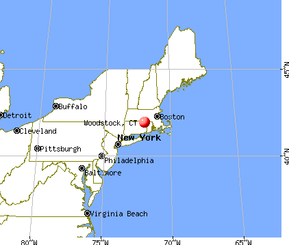
Woodstock, Connecticut
Woodstock: Muddy Pond Woodstock, CT October 2010

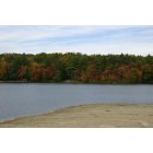
Woodstock: Roseland Lake

Woodstock: Roseland Lake Sunset

Woodstock: view of Roseland Lake from my backyard
- add
your


Submit your own pictures of this town and show them to the world
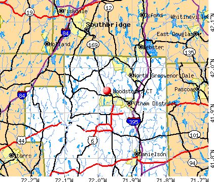
- OSM Map
- General Map
- Google Map
- MSN Map
Population change since 2000: +10.3%
 |
| Males: 3,944 | |
| Females: 4,020 |
| Median resident age: | 44.1 years |
| Connecticut median age: | 39.2 years |
Zip codes: 06281.
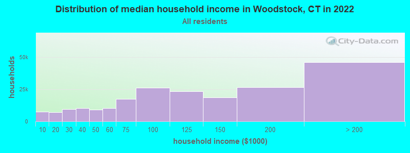
| Woodstock: | $90,688 |
| CT: | $88,429 |
Estimated per capita income in 2022: $45,422 (it was $25,331 in 2000)
Woodstock town income, earnings, and wages data
Estimated median house or condo value in 2022: $309,799 (it was $143,300 in 2000)
| Woodstock: | $309,799 |
| CT: | $347,200 |
Mean prices in 2022: all housing units: $270,250; detached houses: $283,786; townhouses or other attached units: $235,819; in 2-unit structures: $159,195; in 3-to-4-unit structures: $165,857; in 5-or-more-unit structures: $105,814; mobile homes: $180,020
Detailed information about poverty and poor residents in Woodstock, CT


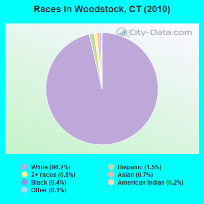
- 7,66296.2%White alone
- 1191.5%Hispanic
- 650.8%Two or more races
- 590.7%Asian alone
- 300.4%Black alone
- 190.2%American Indian alone
- 90.1%Other race alone
- 10.01%Native Hawaiian and Other
Pacific Islander alone
Races in Woodstock detailed stats: ancestries, foreign born residents, place of birth
According to our research of Connecticut and other state lists, there were 8 registered sex offenders living in Woodstock, Connecticut as of May 13, 2024.
The ratio of all residents to sex offenders in Woodstock is 996 to 1.
The ratio of registered sex offenders to all residents in this city is lower than the state average.
 Recent articles from our blog. Our writers, many of them Ph.D. graduates or candidates, create easy-to-read articles on a wide variety of topics.


 | 2024 Connecticut Town Tournament VI (Celebrating the 10-Year Anniversary & Dazzleman's Memorial) (915 replies) |
| Connecticut TOWN TOURNAMENT V (2022) (831 replies) |
| Current Real estate markets (3987 replies) |
| Windham County schools (Woodstock, Thompson, Killingly, etc) (3 replies) |
| Why are Manchester Housing Prices so low? (94 replies) |
| Connecticut TOWN TOURNAMENT IV (2020) (849 replies) |
Latest news from Woodstock, CT collected exclusively by city-data.com from local newspapers, TV, and radio stations
Woodstock, CT City Guides:
Ancestries: French (18.1%), Irish (17.6%), English (15.6%), German (10.5%), Polish (10.4%), French Canadian (9.4%).
Current Local Time: EST time zone
Incorporated on 03/1690
Elevation: 592 feet
Land area: 60.5 square miles.
Population density: 132 people per square mile (very low).
206 residents are foreign born (1.6% Europe, 0.5% Asia, 0.4% North America).
| This town: | 2.9% |
| Connecticut: | 10.9% |
| Woodstock town: | 1.3% ($1,929) |
| Connecticut: | 1.8% ($2,961) |
Nearest city with pop. 50,000+: Worcester, MA  (23.8 miles , pop. 172,648).
Nearest city with pop. 200,000+: Boston, MA (53.4 miles , pop. 589,141).
Nearest city with pop. 1,000,000+: Bronx, NY (123.6 miles , pop. 1,332,650).
Nearest cities:
), ), ), ), Latitude: 41.96 N, Longitude: 72.01 W

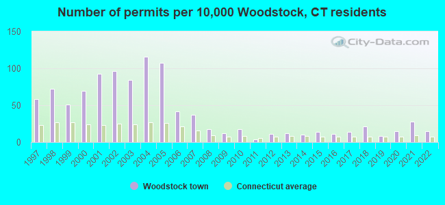
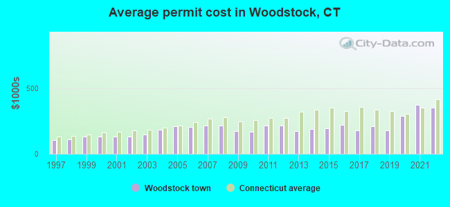
Single-family new house construction building permits:
- 2022: 11 buildings, average cost: $350,700
- 2021: 20 buildings, average cost: $376,200
- 2020: 11 buildings, average cost: $287,900
- 2019: 6 buildings, average cost: $179,700
- 2018: 15 buildings, average cost: $209,200
- 2017: 10 buildings, average cost: $179,100
- 2016: 8 buildings, average cost: $221,200
- 2015: 10 buildings, average cost: $193,800
- 2014: 7 buildings, average cost: $189,200
- 2013: 9 buildings, average cost: $174,200
- 2012: 8 buildings, average cost: $217,300
- 2011: 3 buildings, average cost: $213,500
- 2010: 13 buildings, average cost: $167,200
- 2009: 9 buildings, average cost: $176,100
- 2008: 13 buildings, average cost: $214,500
- 2007: 27 buildings, average cost: $215,400
- 2006: 30 buildings, average cost: $204,000
- 2005: 77 buildings, average cost: $213,300
- 2004: 84 buildings, average cost: $183,900
- 2003: 61 buildings, average cost: $145,300
- 2002: 69 buildings, average cost: $133,700
- 2001: 67 buildings, average cost: $130,700
- 2000: 50 buildings, average cost: $133,700
- 1999: 37 buildings, average cost: $134,000
- 1998: 52 buildings, average cost: $112,600
- 1997: 42 buildings, average cost: $104,200
| Here: | 3.1% |
| Connecticut: | 3.9% |
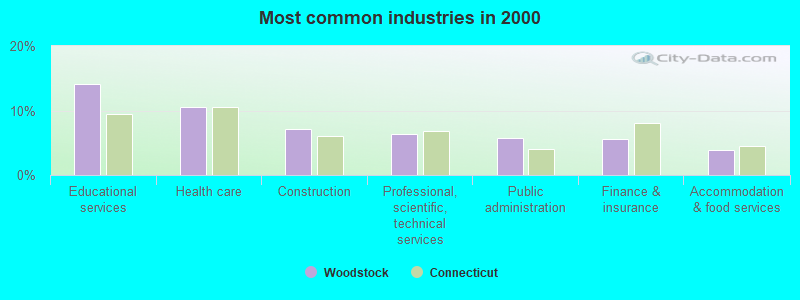
- Educational services (14.1%)
- Health care (10.5%)
- Construction (7.1%)
- Professional, scientific, technical services (6.3%)
- Public administration (5.7%)
- Finance & insurance (5.6%)
- Accommodation & food services (3.9%)
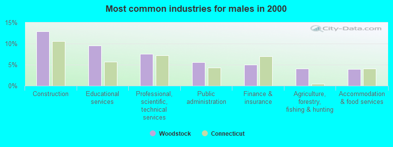
- Construction (12.9%)
- Educational services (9.5%)
- Professional, scientific, technical services (7.5%)
- Public administration (5.5%)
- Finance & insurance (5.0%)
- Agriculture, forestry, fishing & hunting (4.0%)
- Accommodation & food services (3.9%)
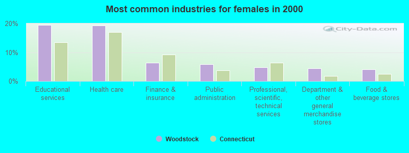
- Educational services (19.4%)
- Health care (19.2%)
- Finance & insurance (6.3%)
- Public administration (5.9%)
- Professional, scientific, technical services (4.9%)
- Department & other general merchandise stores (4.4%)
- Food & beverage stores (4.0%)
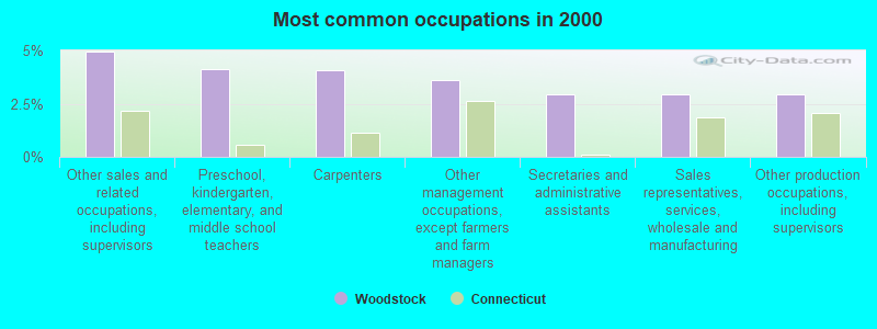
- Other sales and related occupations, including supervisors (4.9%)
- Preschool, kindergarten, elementary, and middle school teachers (4.1%)
- Carpenters (4.1%)
- Other management occupations, except farmers and farm managers (3.6%)
- Secretaries and administrative assistants (2.9%)
- Sales representatives, services, wholesale and manufacturing (2.9%)
- Other production occupations, including supervisors (2.9%)
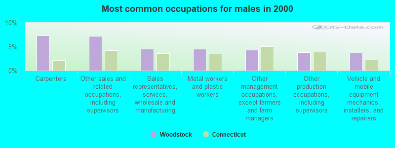
- Carpenters (7.3%)
- Other sales and related occupations, including supervisors (7.2%)
- Sales representatives, services, wholesale and manufacturing (4.6%)
- Metal workers and plastic workers (4.5%)
- Other management occupations, except farmers and farm managers (4.4%)
- Other production occupations, including supervisors (3.8%)
- Vehicle and mobile equipment mechanics, installers, and repairers (3.7%)
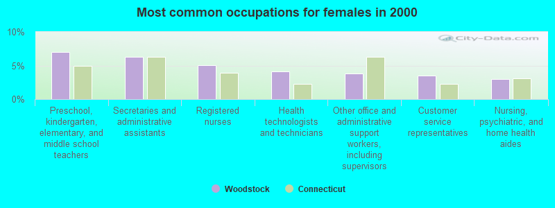
- Preschool, kindergarten, elementary, and middle school teachers (7.0%)
- Secretaries and administrative assistants (6.3%)
- Registered nurses (5.0%)
- Health technologists and technicians (4.1%)
- Other office and administrative support workers, including supervisors (3.9%)
- Customer service representatives (3.5%)
- Nursing, psychiatric, and home health aides (3.0%)
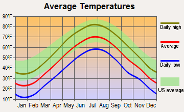
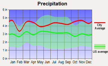
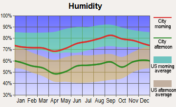
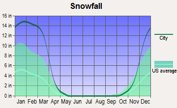
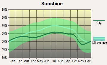
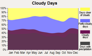
Average climate in Woodstock, Connecticut
Based on data reported by over 4,000 weather stations

(lower is better)
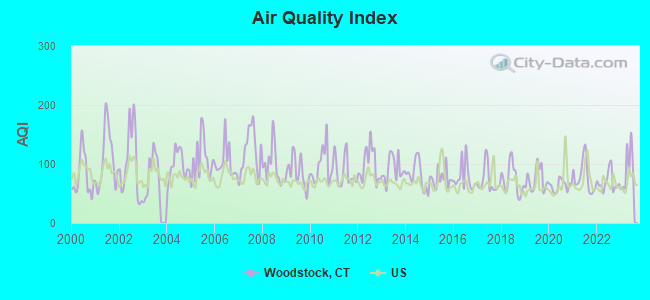
Air Quality Index (AQI) level in 2023 was 91.2. This is worse than average.
| City: | 91.2 |
| U.S.: | 72.6 |
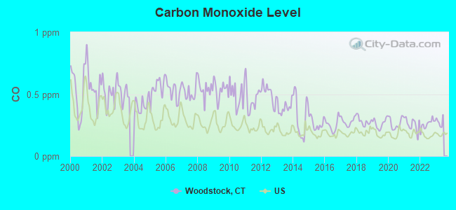
Carbon Monoxide (CO) [ppm] level in 2022 was 0.259. This is about average. Closest monitor was 23.2 miles away from the city center.
| City: | 0.259 |
| U.S.: | 0.251 |
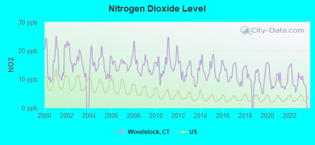
Nitrogen Dioxide (NO2) [ppb] level in 2022 was 10.1. This is significantly worse than average. Closest monitor was 5.8 miles away from the city center.
| City: | 10.1 |
| U.S.: | 5.1 |
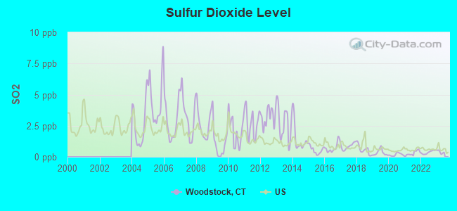
Sulfur Dioxide (SO2) [ppb] level in 2022 was 0.370. This is significantly better than average. Closest monitor was 5.8 miles away from the city center.
| City: | 0.370 |
| U.S.: | 1.515 |
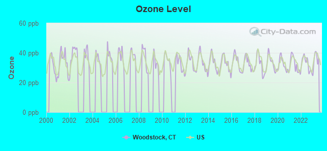
Ozone [ppb] level in 2023 was 35.2. This is about average. Closest monitor was 7.7 miles away from the city center.
| City: | 35.2 |
| U.S.: | 33.3 |
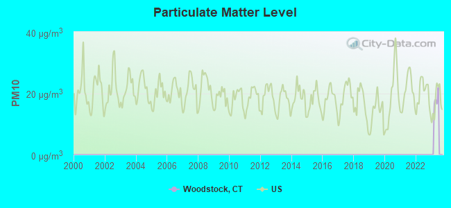
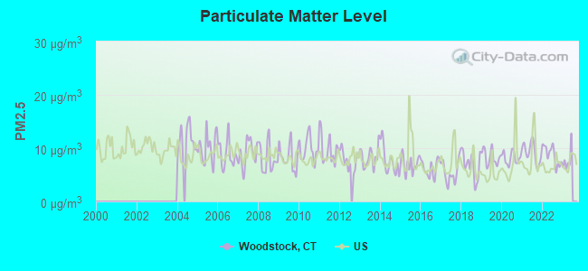
Particulate Matter (PM2.5) [µg/m3] level in 2022 was 8.71. This is about average. Closest monitor was 17.7 miles away from the city center.
| City: | 8.71 |
| U.S.: | 8.11 |
Tornado activity:
Woodstock-area historical tornado activity is near Connecticut state average. It is 24% smaller than the overall U.S. average.
On 6/9/1953, a category F4 (max. wind speeds 207-260 mph) tornado 34.4 miles away from the Woodstock town center killed 90 people and injured 1228 people and caused between $50,000,000 and $500,000,000 in damages.
On 10/3/1979, a category F4 tornado 34.4 miles away from the town center killed 3 people and injured 500 people and caused between $50,000,000 and $500,000,000 in damages.
Earthquake activity:
Woodstock-area historical earthquake activity is significantly above Connecticut state average. It is 72% smaller than the overall U.S. average.On 10/7/1983 at 10:18:46, a magnitude 5.3 (5.1 MB, 5.3 LG, 5.1 ML, Class: Moderate, Intensity: VI - VII) earthquake occurred 181.4 miles away from Woodstock center
On 4/20/2002 at 10:50:47, a magnitude 5.3 (5.3 ML, Depth: 3.0 mi) earthquake occurred 195.9 miles away from the city center
On 4/20/2002 at 10:50:47, a magnitude 5.2 (5.2 MB, 4.2 MS, 5.2 MW, 5.0 MW) earthquake occurred 194.8 miles away from the city center
On 1/19/1982 at 00:14:42, a magnitude 4.7 (4.5 MB, 4.7 MD, 4.5 LG, Class: Light, Intensity: IV - V) earthquake occurred 108.5 miles away from Woodstock center
On 10/16/2012 at 23:12:25, a magnitude 4.7 (4.7 ML, Depth: 10.0 mi) earthquake occurred 132.4 miles away from the city center
On 8/22/1992 at 12:20:32, a magnitude 4.8 (4.8 MB, 3.8 MS, 4.7 LG, Depth: 6.2 mi) earthquake occurred 216.5 miles away from the city center
Magnitude types: regional Lg-wave magnitude (LG), body-wave magnitude (MB), duration magnitude (MD), local magnitude (ML), surface-wave magnitude (MS), moment magnitude (MW)
Natural disasters:
The number of natural disasters in Windham County (24) is greater than the US average (15).Major Disasters (Presidential) Declared: 13
Emergencies Declared: 11
Causes of natural disasters: Hurricanes: 6, Storms: 6, Floods: 4, Snowstorms: 4, Blizzards: 3, Snows: 3, Winter Storms: 3, Snowfall: 1, Tropical Storm: 1, Wind: 1, Other: 1 (Note: some incidents may be assigned to more than one category).
Hospitals and medical centers near Woodstock:
- HOLY SPIRIT HEALTH CARE INC (Nursing Home, about 6 miles away; PUTNAM, CT)
- DAY KIMBALL HOSPITAL Acute Care Hospitals (about 7 miles away; PUTNAM, CT)
- LIBERTY HOUSE (Nursing Home, about 8 miles away; SOUTHBRIDGE, MA)
- PROVIDENCE HOUSE N H OF SOUTHBRIDGE (Nursing Home, about 8 miles away; SOUTHBRIDGE, MA)
- RADIUS HEALTHCARE-SOUTHBRIDGE (Nursing Home, about 8 miles away; SOUTHBRIDGE, MA)
- HARRINGTON MEMORIAL HOSPITAL Acute Care Hospitals (about 9 miles away; SOUTHBRIDGE, MA)
- MATULAITIS NURSING HOME (Nursing Home, about 9 miles away; PUTNAM, CT)
Colleges/universities with over 2000 students nearest to Woodstock:
- University of Connecticut (about 17 miles; Storrs, CT; Full-time enrollment: 22,037)
- Eastern Connecticut State University (about 20 miles; Willimantic, CT; FT enrollment: 4,985)
- College of the Holy Cross (about 22 miles; Worcester, MA; FT enrollment: 3,125)
- Clark University (about 23 miles; Worcester, MA; FT enrollment: 3,687)
- Worcester State University (about 23 miles; Worcester, MA; FT enrollment: 5,426)
- Worcester Polytechnic Institute (about 25 miles; Worcester, MA; FT enrollment: 3,930)
- Bryant University (about 25 miles; Smithfield, RI; FT enrollment: 3,440)
Public high school in Woodstock:
- WOODSTOCK ACADEMY (Students: 1,142, Location: 57 ACADEMY ROAD, Grades: 9-12)
Public elementary/middle schools in Woodstock:
- WOODSTOCK ELEMENTARY SCHOOL (Students: 618, Location: 24 FROG POND ROAD, Grades: PK-4)
- WOODSTOCK MIDDLE SCHOOL (Students: 376, Location: 147 ROUTE 169, Grades: 5-8)
Libraries in Woodstock:
- HOWARD W. BRACKEN MEMORIAL LIBRARY (Operating income: $22,412; Location: 57 ACADEMY ROAD; 25,140 books; 25 e-books; 500 audio materials; 1,700 video materials; 3 local licensed databases; 30 state licensed databases; 40 print serial subscriptions; 5 electronic serial subscriptions)
- WEST WOODSTOCK LIBRARY ASSOCIATION (Operating income: $15,870; Location: 5 BUNGAY HILL CONNECTOR; 7,354 books; 158 audio materials; 258 video materials; 36 state licensed databases; 93 print serial subscriptions)
- NORTH WOODSTOCK LIBRARY (Operating income: $15,274; Location: 1286 RT. 169; 10 books; 114 audio materials; 562 video materials; 30 state licensed databases; 1 other licensed databases; 9 print serial subscriptions)
Points of interest:
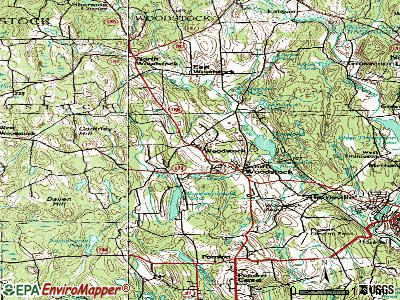
Notable locations in Woodstock: Saint Mary Camp (A), Woodstock Golf Course (B), Woodstock Fairgrounds (C), Camp Woodstock (D), Camp Keemosahbee (E), Meadowside Campground (F), Manna Campground (G), Black Pond Campground (H), Harrisville Golf Club (I), Chamberlain Lake Campground (J), Evergreen Park (K), Woodstock Fire Department Station 76 (L), Woodstock Town Highway Garage (M), Woodstock Town Hall (N), West Woodstock Library (O), Roseland Cottage (P), Photomobile Model Museum (Q), North Woodstock Library (R), Muddy Brook Fire Department Station 75 (S), May Memorial Library (T). Display/hide their locations on the map
Shopping Center: Little River Plaza Shopping Center (1). Display/hide its location on the map
Churches in Woodstock include: Church of the Good Shepherd (A), East Woodstock Congregational Church (B), Eastford Congregational Church (C), Evangelical Covenant Church (D), First Congregational Church of Woodstock (E), South Woodstock Baptist Church (F). Display/hide their locations on the map
Cemeteries: Bungee Cemetery (1), Quasset Cemetery (2), Woodstock Hill Cemetery (3), Woodstock Central Cemetery (4), Elmvale Cemetery (5), Marcy Cemetery (6), East Woodstock Cemetery (7). Display/hide their locations on the map
Lakes, reservoirs, and swamps: Cedar Swamp Pond (A), Wappaquasset Pond (B), Dickinson Pond (C), Hatchet Pond (D), Hiscox Pond (E), Keach Pond (F), Potter Pond (G), Morse Pond (H). Display/hide their locations on the map
Streams, rivers, and creeks: Little Brook (A), Lost Pond Brook (B), Mascraft Brook (C), May Brook (D), Mill Brook (E), Muddy Brook (F), North Ashford Brook (G), North Running Brook (H), Peake Brook (I). Display/hide their locations on the map
Park in Woodstock: Solair Recreation League (1). Display/hide its location on the map
Beach: Woodstock Town Beach (A). Display/hide its location on the map
Tourist attraction: Brighter Skies Balloon CO (77 Bull Hill Road) (1). Display/hide its approximate location on the map
Hotel: Inn at Woodstock Hill (94 Plaine Hill Road) (1). Display/hide its approximate location on the map
Birthplace of: Amasa Walker - Representative and economist, Caleb Davis - Politician, Kenneth Lee Pike - Linguist, Samuel C. Crafts - Politician, George McClellan (physician) - Physician, Jared W. Williams - Politician.
Drinking water stations with addresses in Woodstock and their reported violations in the past:
HYDE SCHOOL - SYSTEM #2 (RESIDENTIAL) (Population served: 310, Groundwater):Past health violations:SOLAIR RECREATIONAL LEAGUE - LOWER RIDGE (Population served: 150, Groundwater):Past monitoring violations:
- MCL, Average - Between APR-2011 and JUN-2011, Contaminant: Arsenic. Follow-up actions: St BCA signed (FEB-04-2010), St Public Notif requested (JUN-14-2011), St Violation/Reminder Notice (JUN-14-2011), St Public Notif received (JUL-02-2011), St Compliance achieved (SEP-30-2011)
- MCL, Average - Between JAN-2011 and MAR-2011, Contaminant: Arsenic. Follow-up actions: St BCA signed (FEB-04-2010), St Public Notif requested (MAR-14-2011), St Violation/Reminder Notice (MAR-14-2011), St Public Notif received (MAR-25-2011), St Compliance achieved (SEP-30-2011)
- MCL, Average - Between OCT-2010 and DEC-2010, Contaminant: Arsenic. Follow-up actions: St BCA signed (FEB-04-2010), St Public Notif requested (DEC-13-2010), St Violation/Reminder Notice (DEC-13-2010), St Public Notif received (DEC-22-2010), St Compliance achieved (SEP-30-2011)
- MCL, Average - Between JUL-2010 and SEP-2010, Contaminant: Arsenic. Follow-up actions: St BCA signed (FEB-04-2010), St Public Notif requested (SEP-20-2010), St Violation/Reminder Notice (SEP-20-2010), St Public Notif received (SEP-29-2010), St Compliance achieved (SEP-30-2011)
- MCL, Average - Between APR-2010 and JUN-2010, Contaminant: Arsenic. Follow-up actions: St BCA signed (FEB-04-2010), St Public Notif requested (JUL-14-2010), St Violation/Reminder Notice (JUL-14-2010), St Public Notif received (AUG-06-2010), St Compliance achieved (SEP-30-2011)
- MCL, Average - Between JAN-2010 and MAR-2010, Contaminant: Arsenic. Follow-up actions: St BCA signed (FEB-04-2010), St Public Notif requested (APR-13-2010), St Violation/Reminder Notice (APR-13-2010), St Public Notif received (APR-30-2010), St Compliance achieved (SEP-30-2011)
- 10 other older health violations
- Monitoring and Reporting (DBP) - Between JAN-2011 and DEC-2011, Contaminant: Total Haloacetic Acids (HAA5). Follow-up actions: St Public Notif requested (MAR-21-2012), St Violation/Reminder Notice (MAR-21-2012), St Compliance achieved (DEC-31-2012), St Public Notif received (JAN-14-2014)
- Monitoring and Reporting (DBP) - Between JAN-2011 and DEC-2011, Contaminant: TTHM. Follow-up actions: St Public Notif requested (MAR-21-2012), St Violation/Reminder Notice (MAR-21-2012), St Compliance achieved (DEC-31-2012), St Public Notif received (JAN-14-2014)
- 2 regular monitoring violations
Past monitoring violations:PINECREST CONDOMINIUMS (Population served: 110, Groundwater):
- Initial Tap Sampling for Pb and Cu - In JAN-01-2010, Contaminant: Lead and Copper Rule. Follow-up actions: St Public Notif requested (MAR-10-2010), St Violation/Reminder Notice (MAR-10-2010), St Public Notif received (FEB-14-2014)
- 145 regular monitoring violations
Past health violations:ROSELAND TERRACE ASSOCIATION, INC. (Population served: 100, Groundwater):
- MCL, Monthly (TCR) - In AUG-2014, Contaminant: Coliform. Follow-up actions: St Violation/Reminder Notice (SEP-25-2014), St Public Notif requested (SEP-25-2014)
- MCL, Average - Between OCT-2010 and DEC-2010, Contaminant: Arsenic. Follow-up actions: St BCA signed (AUG-01-2008), St Public Notif requested (JAN-10-2011), St Violation/Reminder Notice (JAN-10-2011), St Public Notif received (FEB-14-2011), St Compliance achieved (MAR-31-2011)
- MCL, Average - Between JUL-2010 and SEP-2010, Contaminant: Arsenic. Follow-up actions: St BCA signed (AUG-01-2008), St Public Notif requested (AUG-05-2010), St Violation/Reminder Notice (AUG-05-2010), St Public Notif received (AUG-13-2010), St Compliance achieved (MAR-31-2011)
- MCL, Average - Between APR-2010 and JUN-2010, Contaminant: Arsenic. Follow-up actions: St BCA signed (AUG-01-2008), St Public Notif requested (MAY-26-2010), St Violation/Reminder Notice (MAY-26-2010), St Public Notif received (JUN-01-2010), St Compliance achieved (MAR-31-2011)
- MCL, Average - Between JAN-2010 and MAR-2010, Contaminant: Arsenic. Follow-up actions: St BCA signed (AUG-01-2008), St Public Notif requested (FEB-17-2010), St Violation/Reminder Notice (FEB-17-2010), St Public Notif received (MAR-17-2010), St Compliance achieved (MAR-31-2011)
- MCL, Average - Between OCT-2009 and DEC-2009, Contaminant: Arsenic. Follow-up actions: St BCA signed (AUG-01-2008), St Public Notif requested (NOV-09-2009), St Violation/Reminder Notice (NOV-09-2009), St Public Notif received (NOV-16-2009), St Compliance achieved (MAR-31-2011)
- 10 other older health violations
Past health violations:FAWN RIDGE ASSOCIATION INC. (Population served: 36, Groundwater):Past monitoring violations:
- MCL, Monthly (TCR) - In JAN-2009, Contaminant: Coliform. Follow-up actions: St Public Notif requested (JAN-29-2009), St Violation/Reminder Notice (JAN-29-2009), St Public Notif received (FEB-10-2009), St Compliance achieved (FEB-28-2009)
- MCL, Monthly (TCR) - In DEC-2008, Contaminant: Coliform. Follow-up actions: St Public Notif requested (DEC-23-2008), St Violation/Reminder Notice (DEC-23-2008), St Public Notif received (DEC-29-2008), St Compliance achieved (FEB-28-2009)
- MCL, Acute (TCR) - In DEC-2008, Contaminant: Coliform. Follow-up actions: St Public Notif requested (DEC-23-2008), St Violation/Reminder Notice (DEC-23-2008), St Public Notif received (DEC-29-2008), St Compliance achieved (FEB-28-2009)
- MCL, Monthly (TCR) - In OCT-2008, Contaminant: Coliform. Follow-up actions: St Public Notif received (OCT-09-2008), St Public Notif requested (OCT-14-2008), St Violation/Reminder Notice (OCT-14-2008), St Compliance achieved (NOV-30-2008)
- MCL, Acute (TCR) - In OCT-2008, Contaminant: Coliform. Follow-up actions: St Public Notif received (OCT-09-2008), St Public Notif requested (OCT-14-2008), St Violation/Reminder Notice (OCT-14-2008), St Compliance achieved (NOV-30-2008)
- MCL, Monthly (TCR) - In AUG-2007, Contaminant: Coliform. Follow-up actions: St Public Notif requested (AUG-15-2007), St Violation/Reminder Notice (AUG-15-2007), St Public Notif received (AUG-24-2007), St Compliance achieved (MAR-31-2008)
- 4 other older health violations
- Monitoring, Repeat Major (TCR) - In JAN-2009, Contaminant: Coliform (TCR). Follow-up actions: St Compliance achieved (MAR-31-2009)
- One minor monitoring violation
- 3 regular monitoring violations
Past health violations:WOODSTOCK VALLEY MARKETPLACE (Population served: 25, Groundwater):Past monitoring violations:
- MCL, Monthly (TCR) - In MAR-2011, Contaminant: Coliform. Follow-up actions: St Public Notif requested (APR-11-2011), St Violation/Reminder Notice (APR-11-2011), St Compliance achieved (APR-30-2011), St Public Notif received (FEB-10-2014)
- Initial Tap Sampling for Pb and Cu - In JUL-01-2011, Contaminant: Lead and Copper Rule. Follow-up actions: St Public Notif requested (SEP-28-2011), St Violation/Reminder Notice (SEP-28-2011), St Compliance achieved (SEP-30-2011), St Public Notif received (OCT-24-2011)
- 2 routine major monitoring violations
- 376 regular monitoring violations
Past monitoring violations:
- One routine major monitoring violation
Drinking water stations with addresses in Woodstock that have no violations reported:
- WOODSTOCK TOWN HALL (Population served: 39, Primary Water Source Type: Groundwater)
| This town: | 2.5 people |
| Connecticut: | 2.5 people |
| This town: | 73.9% |
| Whole state: | 66.3% |
| This town: | 6.4% |
| Whole state: | 6.6% |
Likely homosexual households (counted as self-reported same-sex unmarried-partner households)
- Lesbian couples: 0.5% of all households
- Gay men: 0.4% of all households
| This town: | 4.2% |
| Whole state: | 7.9% |
| This town: | 1.4% |
| Whole state: | 3.9% |
Banks with branches in Woodstock (2011 data):
- First Niagara Bank, National Association: Woodstock Branch at 258 Route 171, branch established on 1995/03/08. Info updated 2011/06/09: Bank assets: $32,750.6 mil, Deposits: $19,595.4 mil, headquarters in Buffalo, NY, positive income, Commercial Lending Specialization, 351 total offices, Holding Company: First Niagara Financial Group, Inc.
- The Citizens National Bank: The Woodstock Branch at 148 Route 171, branch established on 1975/08/29. Info updated 2006/11/03: Bank assets: $340.5 mil, Deposits: $198.0 mil, headquarters in Putnam, CT, positive income, 5 total offices, Holding Company: Citizens National Bancorp, Inc.
For population 15 years and over in Woodstock:
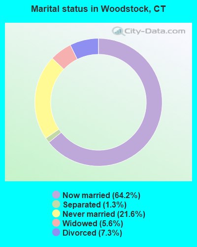
- Never married: 21.6%
- Now married: 64.2%
- Separated: 1.3%
- Widowed: 5.6%
- Divorced: 7.3%
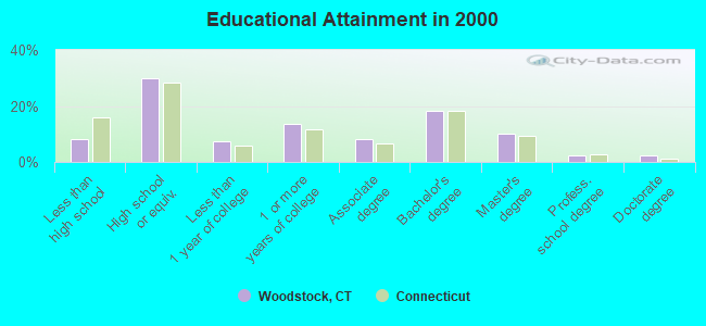
For population 25 years and over in Woodstock:
- High school or higher: 91.7%
- Bachelor's degree or higher: 32.8%
- Graduate or professional degree: 14.7%
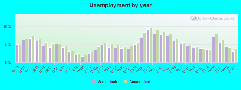
- Unemployed: 3.2%
- Mean travel time to work (commute): 29.0 minutes
| Here: | 11.0 |
| Connecticut average: | 12.8 |
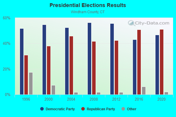
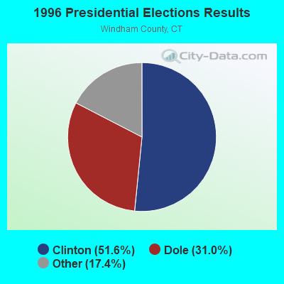
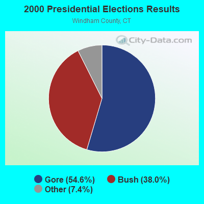
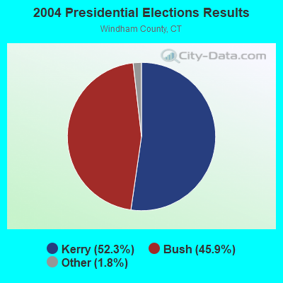
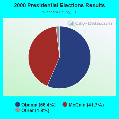

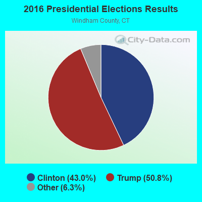
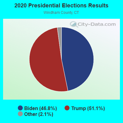
Graphs represent county-level data. Detailed 2008 Election Results
Religion statistics for Woodstock, CT (based on Windham County data)
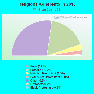
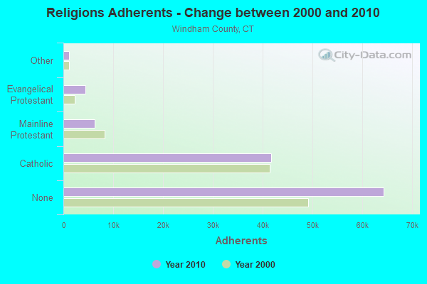
| Religion | Adherents | Congregations |
|---|---|---|
| Catholic | 41,700 | 18 |
| Mainline Protestant | 6,330 | 39 |
| Evangelical Protestant | 4,495 | 37 |
| Other | 1,119 | 12 |
| Orthodox | 205 | 2 |
| Black Protestant | 180 | 1 |
| None | 64,399 | - |
Food Environment Statistics:
| This county: | 1.63 / 10,000 pop. |
| State: | 2.21 / 10,000 pop. |
| This county: | 0.17 / 10,000 pop. |
| Connecticut: | 0.07 / 10,000 pop. |
| Windham County: | 1.11 / 10,000 pop. |
| State: | 1.02 / 10,000 pop. |
| This county: | 3.08 / 10,000 pop. |
| State: | 2.27 / 10,000 pop. |
| Windham County: | 6.76 / 10,000 pop. |
| State: | 9.19 / 10,000 pop. |
| Windham County: | 8.0% |
| Connecticut: | 7.3% |
| Windham County: | 26.6% |
| Connecticut: | 21.5% |
| Here: | 18.7% |
| Connecticut: | 15.8% |
Businesses in Woodstock, CT
- Decora Cabinetry: 2
- MasterBrand Cabinets: 3
- UPS: 1
Strongest AM radio stations in Woodstock:
- WCRN (830 AM; 50 kW; WORCESTER, MA; Owner: CARTER BROADCASTING CORPORATION)
- WALE (990 AM; 50 kW; GREENVILLE, RI; Owner: NORTH AMERICAN BROADCASTING CO., INC.)
- WVNE (760 AM; daytime; 25 kW; LEICESTER, MA; Owner: BLOUNT MASSCOM, INC.)
- WINY (1350 AM; 5 kW; PUTNAM, CT; Owner: OSBREY BROADCASTING COMPANY)
- WNNZ (640 AM; 50 kW; WESTFIELD, MA; Owner: CLEAR CHANNEL BROADCASTING LICENSES, INC.)
- WKOX (1200 AM; 50 kW; FRAMINGHAM, MA; Owner: CAPSTAR TX LIMITED PARTNERSHIP)
- WEEI (850 AM; 50 kW; BOSTON, MA; Owner: ENTERCOM BOSTON LICENSE, LLC)
- WBIX (1060 AM; 40 kW; NATICK, MA; Owner: LANGER BROADCASTING CORPORATION)
- WTIC (1080 AM; 50 kW; HARTFORD, CT; Owner: INFINITY RADIO OPERATIONS INC.)
- WRKO (680 AM; 50 kW; BOSTON, MA; Owner: ENTERCOM BOSTON LICENSE, LLC)
- WAMG (890 AM; 25 kW; DEDHAM, MA; Owner: MEGA COMMUNICATIONS OF DEDHAM LICENSEE, LLC)
- WESO (970 AM; 1 kW; SOUTHBRIDGE, MA)
- WWZN (1510 AM; 50 kW; BOSTON, MA; Owner: ROSE CITY RADIO CORPORATION)
Strongest FM radio stations in Woodstock:
- WWFX (100.1 FM; SOUTHBRIDGE, MA; Owner: CITADEL BROADCASTING COMPANY)
- WORC-FM (98.9 FM; WEBSTER, MA; Owner: CITADEL BROADCASTING COMPANY)
- WBVC (91.1 FM; POMFRET, CT; Owner: POMFRET SCHOOL)
- WAAF (107.3 FM; WORCESTER, MA; Owner: ENTERCOM BOSTON LICENSE, LLC)
- WYCM (90.1 FM; CHARLTON, MA; Owner: BAY PATH VOCATIONAL HIGH SCHOOL)
- WSRS (96.1 FM; WORCESTER, MA; Owner: CAPSTAR TX LIMITED PARTNERSHIP)
- WHUS (91.7 FM; STORRS, CT; Owner: THE BD. OF TRUSTEES, THE UNIV. OF CT)
- W258AC (99.5 FM; STORRS, CT; Owner: CONNECTICUT PUBLIC BROADCASTING, INC)
- WILI-FM (98.3 FM; WILLIMANTIC, CT; Owner: NUTMEG BROADCASTING COMPANY)
- WFCR (88.5 FM; AMHERST, MA; Owner: UNIVERSITY OF MASSACHUSETTS)
- WHYN-FM (93.1 FM; SPRINGFIELD, MA; Owner: CLEAR CHANNEL BROADCASTING LICENSES, INC.)
- WWBB (101.5 FM; PROVIDENCE, RI; Owner: CLEAR CHANNEL BROADCASTING LICENSES, INC.)
- WRCH (100.5 FM; NEW BRITAIN, CT; Owner: INFINITY RADIO OPERATIONS INC.)
- WWKX (106.3 FM; WOONSOCKET, RI; Owner: AAA ENTERTAINMENT LICENSING LLC)
- WBMX (98.5 FM; BOSTON, MA; Owner: INFINITY RADIO OPERATIONS INC.)
- WRNX (100.9 FM; AMHERST, MA; Owner: WESTERN MASSACHUSETTS RADIO COMPANY)
- WWRX-FM (103.7 FM; WESTERLY, RI; Owner: FNX BROADCASTING OF RHODE ISLAND, LLC)
- WJMN (94.5 FM; BOSTON, MA; Owner: AMFM RADIO LICENSES, L.L.C.)
- WCRB (102.5 FM; WALTHAM, MA; Owner: CHARLES RIVER BROADCASTING WCRB LICE)
- WTKK (96.9 FM; BOSTON, MA; Owner: GREATER BOSTON RADIO, INC.)
TV broadcast stations around Woodstock:
- WYDN (Channel 48; WORCESTER, MA; Owner: EDUCATIONAL PUBLIC TV CORPORATION)
- WPXQ (Channel 69; BLOCK ISLAND, RI; Owner: OCEAN STATE TELEVISION, L.L.C.)
- WUNI (Channel 27; WORCESTER, MA; Owner: ENTRAVISION HOLDINGS, LLC)
- WTIC-TV (Channel 61; HARTFORD, CT; Owner: TRIBUNE TELEVISION COMPANY)
- W11BJ (Channel 11; HARTFORD, CT; Owner: COMMUNICATIONS SITE MANAGEMENT LLC)
- WCVB-TV (Channel 5; BOSTON, MA; Owner: WCVB HEARST-ARGYLE TV, INC.)
- WGBH-TV (Channel 2; BOSTON, MA; Owner: WGBH EDUCATIONAL FOUNDATION)
- WUTF (Channel 66; MARLBOROUGH, MA; Owner: TELEFUTURA BOSTON LLC)
- WHPX (Channel 26; NEW LONDON, CT; Owner: PAXSON HARTFORD LICENSE, INC.)
- WTXX (Channel 20; WATERBURY, CT; Owner: WTXX INC.)
- WMFP (Channel 62; LAWRENCE, MA; Owner: WSAH LICENSE, INC.)
- WNAC-TV (Channel 64; PROVIDENCE, RI; Owner: WNAC, LLC)
- WBZ-TV (Channel 4; BOSTON, MA; Owner: VIACOM INC.)
- WGBX-TV (Channel 44; BOSTON, MA; Owner: WGBH EDUCATIONAL FOUNDATION)
- WSBK-TV (Channel 38; BOSTON, MA; Owner: VIACOM INC.)
- WLVI-TV (Channel 56; CAMBRIDGE, MA; Owner: WLVI, INC.)
- WUVN (Channel 18; HARTFORD, CT; Owner: ENTRAVISION HOLDINGS, LLC)
- WPRI-TV (Channel 12; PROVIDENCE, RI; Owner: TVL BROADCASTING OF RHODE ISLAND, LLC)
- WLNE-TV (Channel 6; NEW BEDFORD, MA; Owner: FREEDOM BROADCASTING OF SOUTHERN NEW ENGLAND, INC.)
- WFXT (Channel 25; BOSTON, MA; Owner: FOX TELEVISION STATIONS INC.)
- WJAR (Channel 10; PROVIDENCE, RI; Owner: OUTLET BROADCASTING, INC.)
- WVIT (Channel 30; NEW BRITAIN, CT; Owner: OUTLET BROADCASTING, INC)
- WSBE-TV (Channel 36; PROVIDENCE, RI; Owner: RHODE ISLAND PUBLIC TELECOM. AUTHORITY)
- WRIW-LP (Channel 50; PROVIDENCE, RI; Owner: ZGS PROVIDENCE, INC.)
- WCRN-LP (Channel 34; LEICESTER, MA; Owner: CARTER BROADCASTING CORPORATION)
- National Bridge Inventory (NBI) Statistics
- 10Number of bridges
- 49ft / 15.5mTotal length
- 30,659Total average daily traffic
- 1,076Total average daily truck traffic
- 45,555Total future (year 2036) average daily traffic
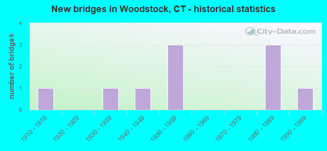
- New bridges - historical statistics
- 11910-1919
- 11930-1939
- 11940-1949
- 31950-1959
- 31980-1989
- 11990-1999
FCC Registered Cell Phone Towers:
2 (See the full list of FCC Registered Cell Phone Towers in Woodstock)FCC Registered Antenna Towers:
34 (See the full list of FCC Registered Antenna Towers)FCC Registered Private Land Mobile Towers:
3- 156 Lebanon Hill Rd (Lat: 42.027028 Lon: -72.035917), Type: Tower, Structure height: 91 m, Call Sign: WPJR828,
Assigned Frequencies: 929.187 MHz, Grant Date: 06/06/1997, Expiration Date: 06/06/2007, Cancellation Date: 08/08/2001, Certifier: Signature On File, Registrant: Fiorio Communications Consulting, 10451 Twin Rivers Rd Ste 207, Columbia, MD 21044, Fax: (301) 596-1121
- 156 Lebanon Hill Rd (Lat: 42.027028 Lon: -72.035917), Type: Tower, Structure height: 91 m, Call Sign: WPJX250,
Assigned Frequencies: 929.387 MHz, Grant Date: 11/29/1996, Expiration Date: 11/29/2006, Cancellation Date: 04/12/2001, Certifier: Signature On File, Registrant: Fiorio Communications Consulting, 10451 Twin Rivers Rd Ste 207, Columbia, MD 21044, Fax: (301) 596-1121
- 156 Lebanon Hill Rd (Lat: 42.027028 Lon: -72.035917), Type: Tower, Structure height: 91 m, Call Sign: WPKS805,
Assigned Frequencies: 929.512 MHz, Grant Date: 06/26/1997, Expiration Date: 06/26/2007, Cancellation Date: 08/08/2001, Certifier: Steven D Jacoby, Registrant: Fiorio Communications Consulting, 10451 Twin Rivers Rd Ste 207, Columbia, MD 21044, Fax: (301) 596-1121
FCC Registered Broadcast Land Mobile Towers:
4- ELEMENTARY SCHOOL, 24 Frog Pond Road (Lat: 41.944056 Lon: -71.962806), Type: Tower, Structure height: 18.2 m, Call Sign: KUU482,
Assigned Frequencies: 46.5400 MHz, Grant Date: 05/03/2014, Expiration Date: 06/28/2024, Registrant: Woodstock Public Works Dept., 215 Coatney Hill Road, Woodstock, CT 06281, Phone: (860) 974-0330, Fax: (860) 974-3103, Email:
- Int Cutler Hill Rd & New Sweden Rd (Lat: 41.928722 Lon: -72.014250), Call Sign: KNBT954, Licensee ID: L00010650,
Assigned Frequencies: 152.885 MHz, Grant Date: 07/07/2001, Expiration Date: 08/20/2011, Cancellation Date: 10/22/2011, Registrant: S A S Construction Inc, 468 New Sweden Rd, Woodstock, CT 06281, Phone: (203) 974-0418
- Butts Rd 0.5 Mi From Int Rd 169 (Lat: 41.927056 Lon: -71.953972), Call Sign: WXD246,
Assigned Frequencies: 49.5400 MHz, Grant Date: 04/09/2013, Expiration Date: 05/11/2023, Cancellation Date: 08/19/2023, Registrant: 159 Butt Road, Woodstock, CT 06281, Phone: (860) 928-5908
- Lat: 41.933056 Lon: -71.951944, Call Sign: WRNR742,
Assigned Frequencies: 158.392 MHz, Grant Date: 08/13/2021, Expiration Date: 08/13/2031, Certifier: David Miller, Registrant: J & S Radio Sales, Inc., 1147 Main St, Willimantic, CT 06226-2013, Phone: (860) 456-2667, Fax: (860) 456-4479, Email:
FCC Registered Microwave Towers:
3 (See the full list of FCC Registered Microwave Towers in this town)FCC Registered Paging Towers:
7 (See the full list of FCC Registered Paging Towers)FCC Registered Amateur Radio Licenses:
41 (See the full list of FCC Registered Amateur Radio Licenses in Woodstock)FAA Registered Aircraft Manufacturers and Dealers:
2 (See the full list of FAA Registered Manufacturers and Dealers in Woodstock)FAA Registered Aircraft:
10 (See the full list of FAA Registered Aircraft)2002 - 2018 National Fire Incident Reporting System (NFIRS) incidents
- Fire incident types reported to NFIRS in Woodstock, CT
- 25955.8%Structure Fires
- 13228.4%Outside Fires
- 469.9%Mobile Property/Vehicle Fires
- 275.8%Other
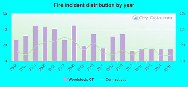 According to the data from the years 2002 - 2018 the average number of fire incidents per year is 27. The highest number of fires - 45 took place in 2008, and the least - 13 in 2014. The data has a dropping trend.
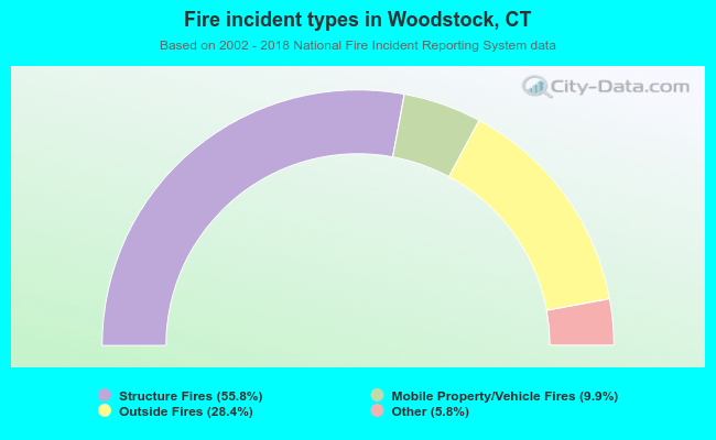 When looking into fire subcategories, the most incidents belonged to: Structure Fires (55.8%), and Outside Fires (28.4%).
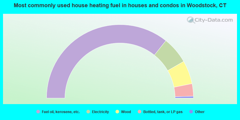
- 71.4%Fuel oil, kerosene, etc.
- 11.9%Electricity
- 10.3%Wood
- 5.5%Bottled, tank, or LP gas
- 0.4%Other fuel
- 0.3%Solar energy
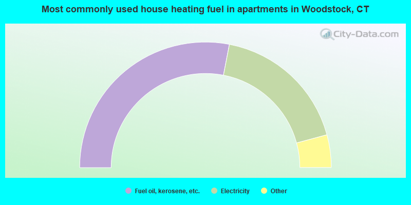
- 56.1%Fuel oil, kerosene, etc.
- 35.5%Electricity
- 3.0%Bottled, tank, or LP gas
- 3.0%Coal or coke
- 1.5%Wood
- 0.9%Other fuel
Woodstock compared to Connecticut state average:
- Unemployed percentage significantly below state average.
- Black race population percentage significantly below state average.
- Hispanic race population percentage significantly below state average.
- Median age above state average.
- Foreign-born population percentage significantly below state average.
- Renting percentage below state average.
- Length of stay since moving in significantly above state average.
- Number of rooms per house significantly below state average.
- House age significantly below state average.
Woodstock on our top lists:
- #8 on the list of "Top 101 cities with largest percentage of males in occupations: carpenters (population 5,000+)"
- #21 on the list of "Top 101 cities with largest percentage of females in occupations: bus drivers (population 5,000+)"
- #28 on the list of "Top 101 cities with largest percentage of females in occupations: judges, magistrates, and other judicial workers (population 5,000+)"
- #32 on the list of "Top 101 cities with largest percentage of males in industries: fuel dealers (population 5,000+)"
- #35 on the list of "Top 101 cities with largest percentage of females in occupations: therapists (population 5,000+)"
- #40 on the list of "Top 101 cities with the most residents born in United Kingdom (population 500+)"
- #40 on the list of "Top 101 cities with the most residents born in Yugoslavia (population 500+)"
- #40 on the list of "Top 101 cities with the most residents born in Asia, n.e.c. (population 500+)"
- #40 on the list of "Top 101 cities with the most residents born in Melanesia (population 500+)"
- #40 on the list of "Top 101 cities with the most residents born in Micronesia (population 500+)"
- #40 on the list of "Top 101 cities with the most residents born in Polynesia (population 500+)"
- #44 on the list of "Top 101 cities with largest percentage of males in occupations: postsecondary teachers (population 5,000+)"
- #46 on the list of "Top 101 cities with largest percentage of males in occupations: other construction workers and helpers (population 5,000+)"
- #47 on the list of "Top 101 cities with largest percentage of females in industries: professional and commercial equipment and supplies merchant wholesalers (population 5,000+)"
- #52 on the list of "Top 101 cities with largest percentage of males in industries: electrical equipment, appliances, and components (population 5,000+)"
- #52 on the list of "Top 101 cities with largest percentage of males in industries: professional and commercial equipment and supplies merchant wholesalers (population 5,000+)"
- #55 on the list of "Top 101 cities with largest percentage of females in industries: office supplies and stationery stores (population 5,000+)"
- #62 on the list of "Top 101 cities with the most residents born in Other South Eastern Asia (population 500+)"
- #63 on the list of "Top 101 cities with largest percentage of males in industries: plastics and rubber products (population 5,000+)"
- #68 on the list of "Top 101 cities with the most residents born in Born at sea (population 500+)"
- #61 (06281) on the list of "Top 101 zip codes with the largest percentage of French Canadian first ancestries (pop 5,000+)"
- #43 on the list of "Top 101 counties with the lowest total withdrawal of fresh water for public supply (pop. 50,000+)"
- #44 on the list of "Top 101 counties with the lowest surface withdrawal of fresh water for public supply (pop. 50,000+)"
- #60 on the list of "Top 101 counties with the lowest number of births per 1000 residents 2007-2013"
- #65 on the list of "Top 101 counties with highest percentage of residents voting for Obama (Democrat) in the 2012 Presidential Election"
- #95 on the list of "Top 101 counties with the largest decrease in the number of deaths per 1000 residents 2000-2006 to 2007-2013 (pop. 50,000+)"
State forum archive:

|
|
Total of 91 patent applications in 2008-2024.