Whiting, Maine
Submit your own pictures of this town and show them to the world
- OSM Map
- General Map
- Google Map
- MSN Map
Population change since 2000: +13.3%
 |
| Males: 241 | |
| Females: 246 |
| Median resident age: | 48.0 years |
| Maine median age: | 43.0 years |
Zip codes: 04691.
| Whiting: | $57,603 |
| ME: | $69,543 |
Estimated per capita income in 2022: $31,083 (it was $13,771 in 2000)
Whiting town income, earnings, and wages data
Estimated median house or condo value in 2022: $202,008 (it was $83,200 in 2000)
| Whiting: | $202,008 |
| ME: | $290,600 |
Mean prices in 2022: all housing units: $208,896; detached houses: $229,377; townhouses or other attached units: $190,242; in 2-unit structures: $139,050; in 3-to-4-unit structures: $456,045; in 5-or-more-unit structures: $413,457; mobile homes: $94,515; occupied boats, rvs, vans, etc.: $45,679
Detailed information about poverty and poor residents in Whiting, ME
Compare current foreclosures near Whiting, ME:
| Photo | Address | Area | Beds / Baths | Price | Details |
|---|---|---|---|---|---|

|
#1
Cutler Rd
East Machias, ME 04630
|
1,945 sq. feet
|
2 baths 3 beds |
$425,000
|
show details |

|
#2
Cathance Ln
Meddybemps, ME 04657
|
432 sq. feet
|
1 baths 3 beds |
show details | |

|
#3
County Rd
Eastport, ME 04631
|
- sq. feet
|
2 baths 3 beds |
show details | |

|
#4
Number Nine Rd
Cutler, ME 04626
|
- sq. feet
|
- baths - beds |
show details | |

|
#5
Church Ln
Machias, ME 04654
|
- sq. feet
|
- baths - beds |
show details | |

|
Check over 1 million property listings on Foreclosure.com!
|
browse all offers | |||

- 45092.4%White alone
- 112.3%Asian alone
- 91.8%Two or more races
- 61.2%American Indian alone
- 61.2%Hispanic
- 40.8%Other race alone
- 10.2%Black alone

Races in Whiting detailed stats: ancestries, foreign born residents, place of birth
According to our research of Maine and other state lists, there was 1 registered sex offender living in Whiting, Maine as of May 23, 2024.
The ratio of all residents to sex offenders in Whiting is 487 to 1.
The ratio of registered sex offenders to all residents in this city is near the state average.
 Recent articles from our blog. Our writers, many of them Ph.D. graduates or candidates, create easy-to-read articles on a wide variety of topics.

 | Thinking about rural Maine. (27 replies) |
| Suggestions for a Quiet Cottage in the Forest (49 replies) |
| Sorry, Maine - New York is Ruining Rea Estate. (29 replies) |
| homesteading which area, low cost while looking (13 replies) |
| Best town for kids (prior military) (12 replies) |
| Pembroke, ME (24 replies) |
Latest news from Whiting, ME collected exclusively by city-data.com from local newspapers, TV, and radio stations
Ancestries: English (25.3%), United States (16.5%), Irish (9.8%), French (6.5%), Italian (6.5%), German (3.5%).
Current Local Time: EST time zone
Incorporated on 02/15/1825
Elevation: 37 feet
Land area: 46.8 square miles.
Population density: 10 people per square mile (very low).
7 residents are foreign born
| This town: | 1.6% |
| Maine: | 2.9% |
| Whiting town: | 0.9% ($723) |
| Maine: | 1.5% ($1,417) |
Nearest city with pop. 50,000+: Portland, ME  (167.1 miles , pop. 64,249).
Nearest city with pop. 200,000+: Boston, MA (255.3 miles , pop. 589,141).
Nearest city with pop. 1,000,000+: Bronx, NY (430.7 miles , pop. 1,332,650).
Nearest cities:
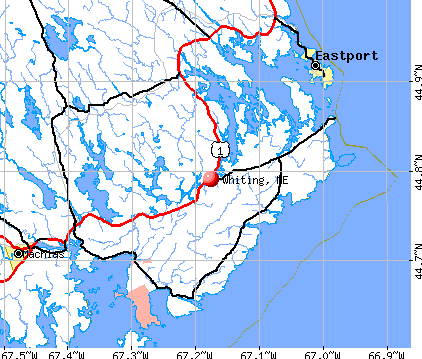
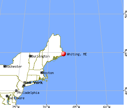
), ), ), Latitude: 44.76 N, Longitude: 67.26 W
Area code commonly used in this area: 207


Single-family new house construction building permits:
- 2020: 2 buildings, average cost: $125,000
- 2019: 1 building, cost: $150,000
- 2018: 1 building, cost: $125,000
- 2017: 1 building, cost: $100,000
- 2016: 2 buildings, average cost: $100,000
- 2015: 1 building, cost: $75,000
- 2014: 1 building, cost: $100,000
- 2013: 3 buildings, average cost: $125,000
- 2012: 3 buildings, average cost: $80,000
- 2011: 3 buildings, average cost: $266,700
- 2010: 4 buildings, average cost: $87,500
- 2008: 2 buildings, average cost: $125,000
- 2007: 7 buildings, average cost: $120,000
- 2006: 6 buildings, average cost: $107,500
- 2005: 2 buildings, average cost: $187,500
- 2004: 9 buildings, average cost: $86,100
- 2003: 10 buildings, average cost: $132,000
- 2002: 11 buildings, average cost: $93,200
- 2001: 3 buildings, average cost: $109,200
- 2000: 2 buildings, average cost: $109,200
- 1999: 2 buildings, average cost: $109,200
- 1998: 1 building, cost: $60,000
- 1997: 1 building, cost: $60,000


| Here: | 3.8% |
| Maine: | 3.4% |


- Educational services (12.8%)
- Public administration (12.3%)
- Health care (8.9%)
- Food (8.4%)
- Agriculture, forestry, fishing & hunting (7.8%)
- U. S. Postal service (5.0%)
- Arts, entertainment, recreation (3.9%)

- Public administration (12.8%)
- Agriculture, forestry, fishing & hunting (11.7%)
- Food (9.6%)
- Educational services (6.4%)
- Construction (5.3%)
- Health care (5.3%)
- Repair & maintenance (5.3%)

- Educational services (20.0%)
- Health care (12.9%)
- Public administration (11.8%)
- Food (7.1%)
- Accommodation & food services (7.1%)
- U. S. Postal service (5.9%)
- Real estate & rental & leasing (5.9%)

- Building and grounds cleaning and maintenance occupations (6.7%)
- Other management occupations, except farmers and farm managers (5.0%)
- Drafters, engineering, and mapping technicians (5.0%)
- Counselors, social workers, and other community and social service specialists (5.0%)
- Driver/sales workers and truck drivers (5.0%)
- Bookkeeping, accounting, and auditing clerks (4.5%)
- Laborers and material movers, hand (4.5%)

- Drafters, engineering, and mapping technicians (9.6%)
- Driver/sales workers and truck drivers (9.6%)
- Electrical equipment mechanics and other installation, maintenance, and repair workers, including supervisors (7.4%)
- Building and grounds cleaning and maintenance occupations (6.4%)
- Fishing, hunting, and forestry occupations (6.4%)
- Other management occupations, except farmers and farm managers (4.3%)
- Agricultural workers, including supervisors (4.3%)

- Counselors, social workers, and other community and social service specialists (10.6%)
- Bookkeeping, accounting, and auditing clerks (9.4%)
- Teachers, special education (8.2%)
- Building and grounds cleaning and maintenance occupations (7.1%)
- Laborers and material movers, hand (7.1%)
- Preschool, kindergarten, elementary, and middle school teachers (5.9%)
- Other management occupations, except farmers and farm managers (5.9%)
Average climate in Whiting, Maine
Based on data reported by over 4,000 weather stations


(lower is better)

Air Quality Index (AQI) level in 2023 was 47.4. This is significantly better than average.
| City: | 47.4 |
| U.S.: | 72.6 |

Ozone [ppb] level in 2023 was 31.6. This is about average. Closest monitor was 14.2 miles away from the city center.
| City: | 31.6 |
| U.S.: | 33.3 |

Particulate Matter (PM2.5) [µg/m3] level in 2022 was 3.12. This is significantly better than average. Closest monitor was 17.4 miles away from the city center.
| City: | 3.12 |
| U.S.: | 8.11 |
Earthquake activity:
Whiting-area historical earthquake activity is above Maine state average. It is 85% smaller than the overall U.S. average.On 10/16/2012 at 23:12:25, a magnitude 4.7 (4.7 ML, Depth: 10.0 mi, Class: Light, Intensity: IV - V) earthquake occurred 186.5 miles away from Whiting center
On 4/20/2002 at 10:50:47, a magnitude 5.3 (5.3 ML, Depth: 3.0 mi, Class: Moderate, Intensity: VI - VII) earthquake occurred 317.2 miles away from the city center
On 4/20/2002 at 10:50:47, a magnitude 5.2 (5.2 MB, 4.2 MS, 5.2 MW, 5.0 MW) earthquake occurred 318.4 miles away from the city center
On 1/19/1982 at 00:14:42, a magnitude 4.7 (4.5 MB, 4.7 MD, 4.5 LG) earthquake occurred 232.2 miles away from Whiting center
On 2/2/2016 at 11:56:22, a magnitude 3.6 (3.6 MB, Depth: 3.1 mi, Class: Light, Intensity: II - III) earthquake occurred 20.4 miles away from the city center
On 10/3/2006 at 00:07:38, a magnitude 3.7 (3.7 MD, Depth: 6.2 mi) earthquake occurred 51.3 miles away from Whiting center
Magnitude types: regional Lg-wave magnitude (LG), body-wave magnitude (MB), duration magnitude (MD), local magnitude (ML), surface-wave magnitude (MS), moment magnitude (MW)
Natural disasters:
The number of natural disasters in Washington County (20) is greater than the US average (15).Major Disasters (Presidential) Declared: 14
Emergencies Declared: 6
Causes of natural disasters: Floods: 11, Storms: 10, Snows: 5, Winds: 2, Winter Storms: 2, Blizzard: 1, Heavy Rain: 1, Hurricane: 1, Ice Storm: 1, Landslide: 1, Snowfall: 1, Other: 2 (Note: some incidents may be assigned to more than one category).

Colleges/universities with over 2000 students nearest to Whiting:
- University of Maine (about 71 miles; Orono, ME; Full-time enrollment: 8,931)
- Husson University (about 76 miles; Bangor, ME; FT enrollment: 2,421)
- University of Maine at Augusta (about 129 miles; Augusta, ME; FT enrollment: 3,204)
- University of Maine at Farmington (about 143 miles; Farmington, ME; FT enrollment: 2,036)
- Southern Maine Community College (about 166 miles; South Portland, ME; FT enrollment: 4,666)
- University of Southern Maine (about 168 miles; Portland, ME; FT enrollment: 6,647)
- Saint Joseph's College of Maine (about 172 miles; Standish, ME; FT enrollment: 2,010)
Public elementary/middle school in Whiting:
- WHITING VILLAGE SCHOOL (Location: NO PHYSICAL LOCATION AVAILABLE, Grades: PK-8)
Points of interest:
Notable location: Whiting Volunteer Fire Department (A). Display/hide its location on the map
Cemetery: Look Cemetery (1). Display/hide its location on the map
Lakes and reservoirs: Western Lake (A), Eastern Lake (B), Holmes Pond (C), Indian Lake (D), Josh Pond (E), Little Lake (F), Orange Lake (G), Sunken Lake (H). Display/hide their locations on the map
Streams, rivers, and creeks: Holmes Stream (A), Lively Brook (B), Reynolds Brook (C), Orange River (D), Crane Brook (E). Display/hide their locations on the map
Drinking water stations with addresses in Whiting and their reported violations in the past:
AOS 96 WHITING VILLAGE SCHOOL (Population served: 45, Groundwater):Past monitoring violations:
- Water Quality Parameter M/R - Between JAN-2006 and JUN-2006, Contaminant: Lead and Copper Rule. Follow-up actions: St Violation/Reminder Notice (JUL-20-2006), St Compliance achieved (AUG-07-2006)
- One routine major monitoring violation
| This town: | 2.4 people |
| Maine: | 2.3 people |
| This town: | 70.4% |
| Whole state: | 62.9% |
| This town: | 9.2% |
| Whole state: | 9.4% |
Likely homosexual households (counted as self-reported same-sex unmarried-partner households)
- Lesbian couples: 1.0% of all households
- Gay men: 0.0% of all households
| This town: | 22.2% |
| Whole state: | 10.9% |
| This town: | 4.8% |
| Whole state: | 4.1% |
For population 15 years and over in Whiting:

- Never married: 23.0%
- Now married: 63.0%
- Separated: 0.6%
- Widowed: 7.3%
- Divorced: 6.1%
For population 25 years and over in Whiting:
- High school or higher: 82.1%
- Bachelor's degree or higher: 17.6%
- Graduate or professional degree: 5.9%
- Unemployed: 3.2%
- Mean travel time to work (commute): 26.8 minutes


| Here: | 9.9 |
| Maine average: | 11.2 |
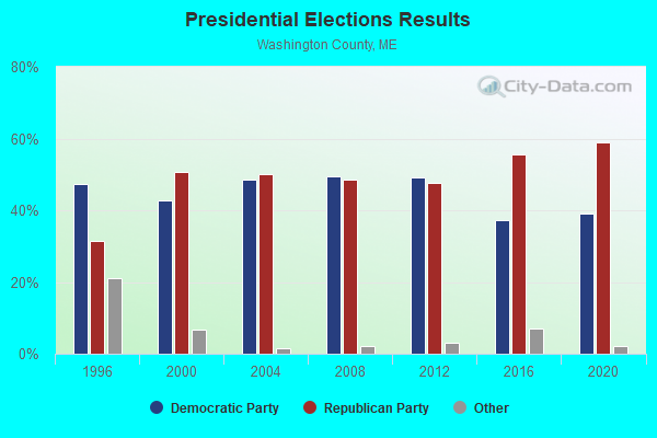

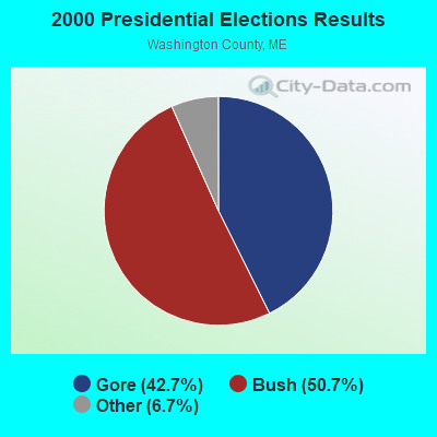
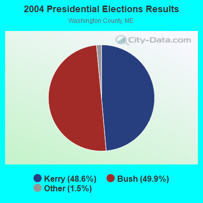

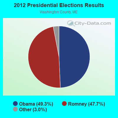
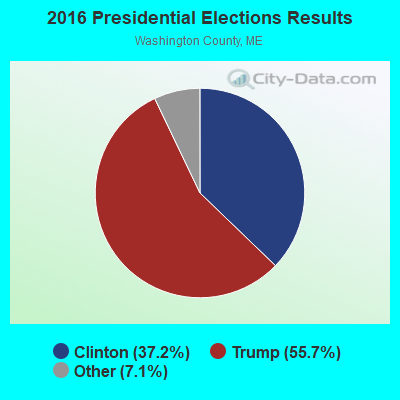
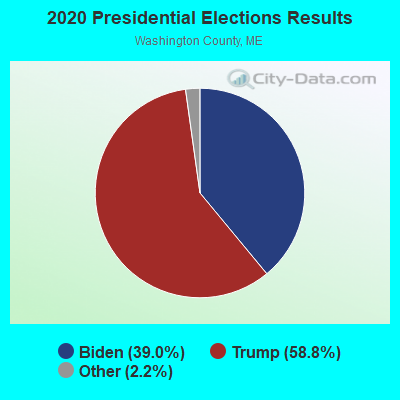
Graphs represent county-level data. Detailed 2008 Election Results
Religion statistics for Whiting, ME (based on Washington County data)
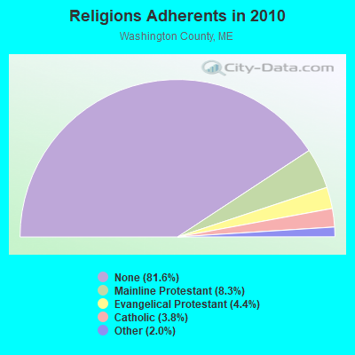
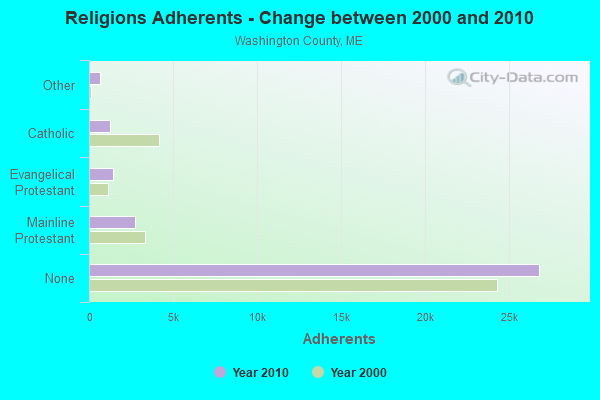
| Religion | Adherents | Congregations |
|---|---|---|
| Mainline Protestant | 2,731 | 37 |
| Evangelical Protestant | 1,442 | 31 |
| Catholic | 1,238 | 10 |
| Other | 648 | 13 |
| None | 26,797 | - |
Food Environment Statistics:
| This county: | 4.89 / 10,000 pop. |
| State: | 2.80 / 10,000 pop. |
| This county: | 1.22 / 10,000 pop. |
| State: | 2.20 / 10,000 pop. |
| This county: | 9.78 / 10,000 pop. |
| Maine: | 5.75 / 10,000 pop. |
| This county: | 11.31 / 10,000 pop. |
| Maine: | 11.02 / 10,000 pop. |
| Here: | 9.4% |
| Maine: | 8.2% |
| Washington County: | 28.3% |
| Maine: | 25.0% |
Strongest AM radio stations in Whiting:
- WZON (620 AM; 5 kW; BANGOR, ME; Owner: THE ZONE CORPORATION)
- WRKO (680 AM; 50 kW; BOSTON, MA; Owner: ENTERCOM BOSTON LICENSE, LLC)
- WABI (910 AM; 5 kW; BANGOR, ME; Owner: CLEAR CHANNEL BROADCASTING LICENSES, INC.)
- WDEA (1370 AM; 5 kW; ELLSWORTH, ME; Owner: CUMULUS LICENSING CORP.)
- WEEI (850 AM; 50 kW; BOSTON, MA; Owner: ENTERCOM BOSTON LICENSE, LLC)
- WBZ (1030 AM; 50 kW; BOSTON, MA; Owner: INFINITY BROADCASTING OPERATIONS, INC.)
- WCRN (830 AM; 50 kW; WORCESTER, MA; Owner: CARTER BROADCASTING CORPORATION)
- WNNZ (640 AM; 50 kW; WESTFIELD, MA; Owner: CLEAR CHANNEL BROADCASTING LICENSES, INC.)
- WSKW (1160 AM; 10 kW; SKOWHEGAN, ME; Owner: MOUNTAIN WIRELESS, INCORPORATED)
- WALE (990 AM; 50 kW; GREENVILLE, RI; Owner: NORTH AMERICAN BROADCASTING CO., INC.)
- WKOX (1200 AM; 50 kW; FRAMINGHAM, MA; Owner: CAPSTAR TX LIMITED PARTNERSHIP)
- WREM (710 AM; daytime; 5 kW; MONTICELLO, ME; Owner: ALLAN H WEINER)
- WBIX (1060 AM; 40 kW; NATICK, MA; Owner: LANGER BROADCASTING CORPORATION)
Strongest FM radio stations in Whiting:
- WMED (89.7 FM; CALAIS, ME; Owner: MAINE PUBLIC BROADCASTING CORPORATION)
- WCRQ (102.9 FM; DENNYSVILLE, ME; Owner: WQDY, INC.)
- WALZ-FM (95.3 FM; MACHIAS, ME; Owner: WILLIAM MCVICAR & ROGER HOLST, GEN. PARTNERSHIP)
- WNSX (97.7 FM; WINTER HARBOR, ME; Owner: CLEAR CHANNEL BROADCASTING LICENSES, INC.)
Whiting fatal accident list:
Aug 6, 2005 05:30 AM, Us-1, Lat: 44.755350, Lon: -67.235110, Vehicles: 1, Persons: 4, Fatalities: 1
Apr 18, 2003 03:05 PM, Us-1, Vehicles: 3, Persons: 9, Fatalities: 1
Aug 12, 1995 01:59 PM, 1, Vehicles: 3, Persons: 10, Fatalities: 2
Nov 9, 1992 05:25 PM, Hallsmills, Vehicles: 1, Persons: 1, Fatalities: 1
Aug 28, 1987 10:50 PM, 70847085, Vehicles: 1, Persons: 1, Fatalities: 1, Drunk persons involved: 1
- National Bridge Inventory (NBI) Statistics
- 5Number of bridges
- 23ft / 6.8mTotal length
- 5,343Total average daily traffic
- 266Total average daily truck traffic
- 7,681Total future (year 2036) average daily traffic
FCC Registered Antenna Towers:
9 (See the full list of FCC Registered Antenna Towers in Whiting)FCC Registered Microwave Towers:
3- WHITING RT 1, Route 1 (Lat: 44.741000 Lon: -67.343333), Type: Gtower, Structure height: 57.9 m, Overall height: 59.1 m, Call Sign: WQSV558,
Assigned Frequencies: 6197.24 MHz, Grant Date: 11/21/2013, Expiration Date: 11/21/2023, Cancellation Date: 04/16/2015, Certifier: John Monday, Registrant: At&t Mobility LLC, 2200 N Greenville Ave., 1w, Richardson, TX 75082, Phone: (972) 234-7003, Fax: (972) 301-6893, Email:
- WHITING_USF, Yellow Birch Road (Lat: 44.775083 Lon: -67.172917), Type: Ltower, Structure height: 70.1 m, Overall height: 71.6 m, Call Sign: WQUF644,
Assigned Frequencies: 11265.0 MHz, 11345.0 MHz, Grant Date: 06/24/2014, Expiration Date: 06/24/2024, Certifier: Steven T Campbell, Registrant: Wilkinson Barker Knauer, LLP, 1800 M Street Nw, Suite 800n, Washington, DC 20036, Phone: (202) 383-3420, Fax: (202) 783-5851, Email:
- WHITING RT 1, Route 1 (Lat: 44.741000 Lon: -67.343333), Type: Gtower, Structure height: 57.9 m, Overall height: 59.1 m, Call Sign: WQXH609,
Assigned Frequencies: 6197.24 MHz, Grant Date: 03/08/2016, Expiration Date: 03/08/2026, Certifier: John E Monday, Registrant: At&t Services, Inc., 208 S Akard St, 20f, Dallas, TX 75202, Phone: (855) 699-7073, Fax: (214) 746-6410, Email:
FCC Registered Maritime Coast & Aviation Ground Towers:
1- Hcr 74 Box 78a (Lat: 44.756472 Lon: -67.261111), Type: Building, Overall height: 12 m, Call Sign: KEA979, Licensee ID: L00015925,
Assigned Frequencies: 156.500 MHz, 156.800 MHz, 156.450 MHz, Grant Date: 03/10/1998, Expiration Date: 03/11/2003, Cancellation Date: 06/15/2003, Registrant: Quoddy Pilots Usa, Hcr 74 Box 78a, Whiting, ME 04691
FCC Registered Amateur Radio Licenses:
13 (See the full list of FCC Registered Amateur Radio Licenses in Whiting)
- 74.3%Fuel oil, kerosene, etc.
- 13.6%Wood
- 10.7%Bottled, tank, or LP gas
- 1.4%Electricity

- 86.7%Fuel oil, kerosene, etc.
- 6.7%Bottled, tank, or LP gas
- 6.7%Wood
Whiting compared to Maine state average:
- Unemployed percentage significantly below state average.
- Black race population percentage significantly below state average.
- Median age above state average.
- Foreign-born population percentage significantly below state average.
- Renting percentage below state average.
- Length of stay since moving in significantly above state average.
- Number of rooms per house significantly below state average.
- House age significantly below state average.
- Percentage of population with a bachelor's degree or higher below state average.