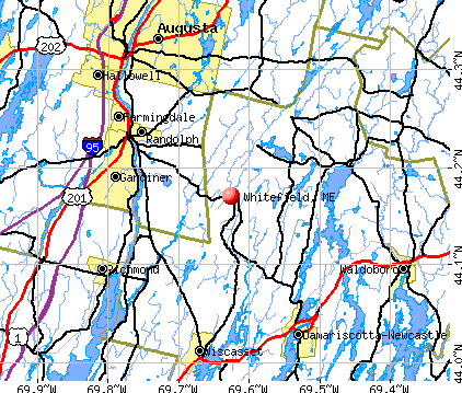
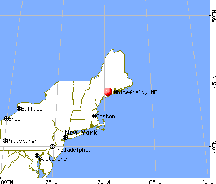
Whitefield, Maine
Submit your own pictures of this town and show them to the world
- OSM Map
- General Map
- Google Map
- MSN Map
Population change since 2000: +1.2%
 |
| Males: 1,157 | |
| Females: 1,143 |
| Median resident age: | 44.1 years |
| Maine median age: | 43.0 years |
Zip codes: 04353.
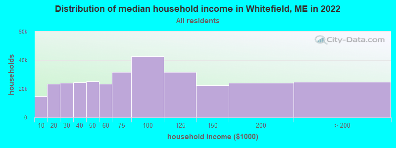
| Whitefield: | $70,573 |
| ME: | $69,543 |
Estimated per capita income in 2022: $35,705 (it was $16,456 in 2000)
Whitefield town income, earnings, and wages data
Estimated median house or condo value in 2022: $236,699 (it was $82,600 in 2000)
| Whitefield: | $236,699 |
| ME: | $290,600 |
Mean prices in 2022: all housing units: $415,956; detached houses: $442,502; townhouses or other attached units: $442,441; in 2-unit structures: $393,150; in 3-to-4-unit structures: $266,359; in 5-or-more-unit structures: $407,319; mobile homes: $150,042; occupied boats, rvs, vans, etc.: $76,651
Detailed information about poverty and poor residents in Whitefield, ME
Compare current foreclosures near Whitefield, ME:
| Photo | Address | Area | Beds / Baths | Price | Details |
|---|---|---|---|---|---|

|
#1
Dr Mann Rd
Augusta, ME 04330
|
1,320 sq. feet
|
2 baths 2 beds |
$315,000
|
show details |

|
#2
Riverside Dr
Vassalboro, ME 04989
|
1,510 sq. feet
|
2 baths 4 beds |
$364,900
|
show details |

|
#3
Washington St
Augusta, ME 04330
|
1,478 sq. feet
|
2 baths 3 beds |
$77,050
|
show details |

|
#4
Hunts Meadow Rd
Windsor, ME 04363
|
2,430 sq. feet
|
3 baths 4 beds |
show details | |

|
#5
W River Rd
Augusta, ME 04330
|
1,440 sq. feet
|
2 baths 4 beds |
show details | |

|
#6
Eastern Ave
Augusta, ME 04330
|
1,344 sq. feet
|
2 baths 3 beds |
show details | |

|
#7
Rabbit Path Rd
Alna, ME 04535
|
- sq. feet
|
2 baths 3 beds |
show details | |

|
#8
Riverside Dr
Augusta, ME 04330
|
1,724 sq. feet
|
2 baths 3 beds |
show details | |

|
#9
Longwood Ave
Augusta, ME 04330
|
1,274 sq. feet
|
1 baths 3 beds |
show details | |

|
#10
Meadow Rd Apt 204
Augusta, ME 04330
|
- sq. feet
|
- baths - beds |
show details |
| Photo | Address | Area | Beds / Baths | Price | Details |
|---|---|---|---|---|---|

|
#11
Pleasant St # 2
Augusta, ME 04330
|
- sq. feet
|
- baths - beds |
show details | |

|
#12
Bangor St
Augusta, ME 04330
|
- sq. feet
|
- baths - beds |
show details | |

|
#13
Cape Hill Rd
Jefferson, ME 04348
|
- sq. feet
|
- baths - beds |
show details | |

|
#14
Row House Ln
Hallowell, ME 04347
|
- sq. feet
|
- baths - beds |
show details | |

|
#15
Daniel Dr
Gardiner, ME 04345
|
- sq. feet
|
- baths - beds |
show details | |

|
#16
Lamson Rd
Augusta, ME 04330
|
- sq. feet
|
- baths - beds |
show details | |

|
#17
Caswell Rd
Windsor, ME 04363
|
- sq. feet
|
- baths - beds |
show details | |

|
#18
Prescott Rd
Manchester, ME 04351
|
1,440 sq. feet
|
- baths - beds |
show details | |

|
#19
Church St
Gardiner, ME 04345
|
- sq. feet
|
- baths - beds |
show details | |

|
#20
White Rd
Bowdoinham, ME 04008
|
- sq. feet
|
- baths - beds |
show details |
| Photo | Address | Area | Beds / Baths | Price | Details |
|---|---|---|---|---|---|

|
#21
Church Hill Rd
Augusta, ME 04330
|
- sq. feet
|
- baths - beds |
show details | |

|
#22
River Rd
Dresden, ME 04342
|
- sq. feet
|
- baths - beds |
show details | |

|
#23
White Rd
Bowdoinham, ME 04008
|
- sq. feet
|
- baths - beds |
show details | |

|
#24
S Clary Rd
Jefferson, ME 04348
|
- sq. feet
|
- baths - beds |
show details | |

|
#25
Genthner Rd
Waldoboro, ME 04572
|
- sq. feet
|
- baths - beds |
show details | |

|
#26
Bowman St
Farmingdale, ME 04344
|
- sq. feet
|
- baths - beds |
show details | |

|
#27
Bowman St
Farmingdale, ME 04344
|
- sq. feet
|
- baths - beds |
show details | |

|
#28
Northern Ave
Farmingdale, ME 04344
|
- sq. feet
|
- baths - beds |
show details | |

|
#29
Birch St
Augusta, ME 04330
|
- sq. feet
|
- baths - beds |
show details | |

|
#30
Main St
Vassalboro, ME 04989
|
- sq. feet
|
- baths - beds |
show details |
| Photo | Address | Area | Beds / Baths | Price | Details |
|---|---|---|---|---|---|

|
Check over 1 million property listings on Foreclosure.com!
|
browse all offers | |||
| Photo | Address | Area | Beds / Baths | Price | Details |
|---|

- 2,22896.9%White alone
- 261.1%Hispanic
- 221.0%Two or more races
- 90.4%American Indian alone
- 80.3%Black alone
- 70.3%Asian alone
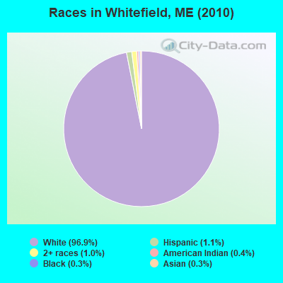
Races in Whitefield detailed stats: ancestries, foreign born residents, place of birth
According to our research of Maine and other state lists, there were 7 registered sex offenders living in Whitefield, Maine as of May 26, 2024.
The ratio of all residents to sex offenders in Whitefield is 329 to 1.
 Recent articles from our blog. Our writers, many of them Ph.D. graduates or candidates, create easy-to-read articles on a wide variety of topics.

 | Well, here goes. The start to our trek North to Maine, our new home-state. (395 replies) |
| Maine's Off-Topic Thread: Part Nine (389 replies) |
| Working in Winslow, Maine (4 replies) |
| Whitefield/Coopers Mills Historical Information (2 replies) |
| Honeybee swarm season has arrived. (12 replies) |
| Possibly moving to Augusta? (4 replies) |
Latest news from Whitefield, ME collected exclusively by city-data.com from local newspapers, TV, and radio stations
Ancestries: English (26.2%), Irish (15.9%), French (12.7%), United States (12.2%), German (9.3%), Scottish (4.8%).
Current Local Time: EST time zone
Incorporated on 06/19/1809
Elevation: 100 feet
Land area: 46.8 square miles.
Population density: 49 people per square mile (very low).
32 residents are foreign born
| This town: | 1.4% |
| Maine: | 2.9% |
| Whitefield town: | 1.4% ($1,164) |
| Maine: | 1.5% ($1,417) |
Nearest city with pop. 50,000+: Portland, ME  (50.2 miles , pop. 64,249).
Nearest city with pop. 200,000+: Boston, MA (150.5 miles , pop. 589,141).
Nearest city with pop. 1,000,000+: Bronx, NY (318.4 miles , pop. 1,332,650).
Nearest cities:
), ), ), ), ), ), )Latitude: 44.21 N, Longitude: 69.60 W
| Here: | 3.1% |
| Maine: | 3.4% |

- Health care (13.0%)
- Public administration (12.2%)
- Construction (7.3%)
- Educational services (5.5%)
- Administrative & support & waste management services (5.0%)
- Transportation equipment (4.0%)
- Professional, scientific, technical services (3.8%)

- Construction (14.4%)
- Public administration (13.2%)
- Administrative & support & waste management services (8.1%)
- Transportation equipment (6.8%)
- Motor vehicle & parts dealers (5.9%)
- Agriculture, forestry, fishing & hunting (5.0%)
- Educational services (4.5%)
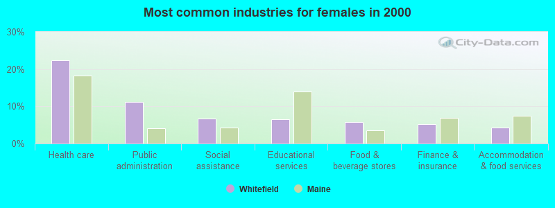
- Health care (22.4%)
- Public administration (11.2%)
- Social assistance (6.7%)
- Educational services (6.5%)
- Food & beverage stores (5.8%)
- Finance & insurance (5.2%)
- Accommodation & food services (4.3%)
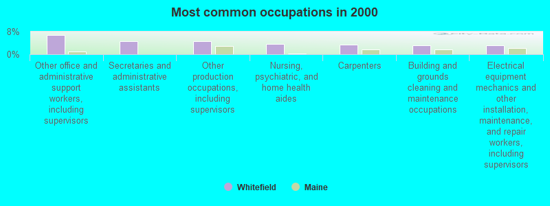
- Other office and administrative support workers, including supervisors (6.9%)
- Secretaries and administrative assistants (4.7%)
- Other production occupations, including supervisors (4.5%)
- Nursing, psychiatric, and home health aides (3.6%)
- Carpenters (3.4%)
- Building and grounds cleaning and maintenance occupations (3.2%)
- Electrical equipment mechanics and other installation, maintenance, and repair workers, including supervisors (3.1%)
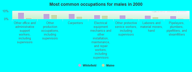
- Other office and administrative support workers, including supervisors (8.1%)
- Other production occupations, including supervisors (6.8%)
- Carpenters (6.6%)
- Electrical equipment mechanics and other installation, maintenance, and repair workers, including supervisors (5.0%)
- Other protective service workers, including supervisors (4.9%)
- Laborers and material movers, hand (4.5%)
- Pipelayers, plumbers, pipefitters, and steamfitters (3.8%)

- Secretaries and administrative assistants (9.6%)
- Nursing, psychiatric, and home health aides (7.4%)
- Other office and administrative support workers, including supervisors (5.6%)
- Child care workers (5.4%)
- Customer service representatives (4.3%)
- Registered nurses (4.0%)
- Information and record clerks, except customer service representatives (4.0%)
Average climate in Whitefield, Maine
Based on data reported by over 4,000 weather stations


(lower is better)
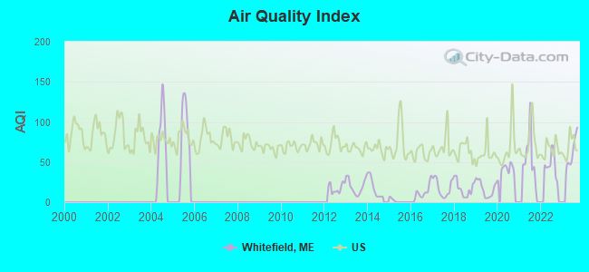
Air Quality Index (AQI) level in 2023 was 62.3. This is about average.
| City: | 62.3 |
| U.S.: | 72.6 |
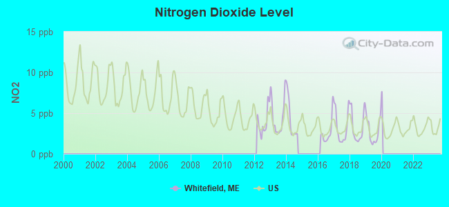
Nitrogen Dioxide (NO2) [ppb] level in 2019 was 2.80. This is significantly better than average. Closest monitor was 9.1 miles away from the city center.
| City: | 2.80 |
| U.S.: | 5.11 |
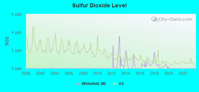
Sulfur Dioxide (SO2) [ppb] level in 2019 was 0.185. This is significantly better than average. Closest monitor was 9.1 miles away from the city center.
| City: | 0.185 |
| U.S.: | 1.515 |
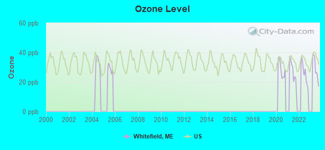
Ozone [ppb] level in 2023 was 29.5. This is about average. Closest monitor was 9.2 miles away from the city center.
| City: | 29.5 |
| U.S.: | 33.3 |


Earthquake activity:
Whitefield-area historical earthquake activity is significantly above Maine state average. It is 77% smaller than the overall U.S. average.On 10/16/2012 at 23:12:25, a magnitude 4.7 (4.7 ML, Depth: 10.0 mi, Class: Light, Intensity: IV - V) earthquake occurred 67.4 miles away from the city center
On 4/20/2002 at 10:50:47, a magnitude 5.3 (5.3 ML, Depth: 3.0 mi, Class: Moderate, Intensity: VI - VII) earthquake occurred 203.5 miles away from the city center
On 4/20/2002 at 10:50:47, a magnitude 5.2 (5.2 MB, 4.2 MS, 5.2 MW, 5.0 MW) earthquake occurred 204.4 miles away from Whitefield center
On 1/19/1982 at 00:14:42, a magnitude 4.7 (4.5 MB, 4.7 MD, 4.5 LG) earthquake occurred 111.0 miles away from Whitefield center
On 10/7/1983 at 10:18:46, a magnitude 5.3 (5.1 MB, 5.3 LG, 5.1 ML) earthquake occurred 236.0 miles away from the city center
On 2/26/1999 at 03:38:43, a magnitude 3.8 (3.8 LG, Depth: 2.0 mi, Class: Light, Intensity: II - III) earthquake occurred 19.1 miles away from Whitefield center
Magnitude types: regional Lg-wave magnitude (LG), body-wave magnitude (MB), duration magnitude (MD), local magnitude (ML), surface-wave magnitude (MS), moment magnitude (MW)
Natural disasters:
The number of natural disasters in Lincoln County (24) is greater than the US average (15).Major Disasters (Presidential) Declared: 19
Emergencies Declared: 4
Causes of natural disasters: Floods: 15, Storms: 11, Winter Storms: 4, Hurricanes: 2, Snows: 2, Winds: 2, Blizzard: 1, Heavy Rain: 1, Ice Storm: 1, Landslide: 1, Snowfall: 1, Tropical Storm: 1, Other: 2 (Note: some incidents may be assigned to more than one category).

Hospitals and medical centers near Whitefield:
- MAINEGENERAL MEDICAL CENTER -GARDINER (Nursing Home, about 9 miles away; GARDINER, ME)
- MERRILL MEMORIAL MANOR (Nursing Home, about 9 miles away; GARDINER, ME)
- ROBINSON HLTH CARE FAC (Nursing Home, about 9 miles away; GARDINER, ME)
- MAINE VETERANS HOME - AUGUSTA (Nursing Home, about 10 miles away; AUGUSTA, ME)
- SUPPORTIVE LIVING SYSTEMS INC (Home Health Center, about 10 miles away; AUGUSTA, ME)
- KINDRED TRANSITIONAL CARE AND REHAB-AUGUSTA (Nursing Home, about 11 miles away; AUGUSTA, ME)
- MAINE GENERAL REHAB AND NURSING AT GLENRIDGE (Nursing Home, about 11 miles away; AUGUSTA, ME)
Colleges/universities with over 2000 students nearest to Whitefield:
- University of Maine at Augusta (about 13 miles; Augusta, ME; Full-time enrollment: 3,204)
- University of Maine at Farmington (about 42 miles; Farmington, ME; FT enrollment: 2,036)
- Southern Maine Community College (about 50 miles; South Portland, ME; FT enrollment: 4,666)
- University of Southern Maine (about 51 miles; Portland, ME; FT enrollment: 6,647)
- Saint Joseph's College of Maine (about 52 miles; Standish, ME; FT enrollment: 2,010)
- Husson University (about 59 miles; Bangor, ME; FT enrollment: 2,421)
- University of New England (about 65 miles; Biddeford, ME; FT enrollment: 4,539)
Public elementary/middle school in Whitefield:
- WHITEFIELD ELEMENTARY SCHOOL (Location: 164 GRAND ARMY ROAD, Grades: KG-8)
Points of interest:
Notable locations in Whitefield: Whitefield Fire and Rescue (A), Kings Mills Fire Department (B), North Whitefield Fire Department (C), Coopers Mills Fire Department (D). Display/hide their locations on the map
Church in Whitefield: Saint Denis Church (A). Display/hide its location on the map
Cemeteries: Preble Cemetery (1), Calvary Cemetery (2), Potter Cemetery (3), Whitefield Cemetery (4), Noyes Cemetery (5). Display/hide their locations on the map
Lakes and reservoirs: Weary Pond (A), Givens Pond (B), Clary Lake (C). Display/hide their locations on the map
Streams, rivers, and creeks: West Branch Sheepscot River (A), Finn Brook (B), Carlton Brook (C). Display/hide their locations on the map
Birthplace of: Eliakim P. Scammon - Union Army general.
Drinking water stations with addresses in Whitefield and their reported violations in the past:
SHEEPSCOT LINKS (Population served: 25, Groundwater):Past health violations:Past monitoring violations:
- MCL, Monthly (TCR) - In AUG-2011, Contaminant: Coliform. Follow-up actions: St Public Notif requested (AUG-15-2011), St Formal NOV issued (AUG-15-2011), St Public Notif received (AUG-18-2011), St Compliance achieved (SEP-06-2011)
- MCL, Monthly (TCR) - In AUG-2007, Contaminant: Coliform. Follow-up actions: St Public Notif requested (AUG-24-2007), St Formal NOV issued (AUG-24-2007), St Public Notif received (SEP-05-2007), St Compliance achieved (SEP-07-2011), St Intentional no-action (SEP-09-2011)
- 2 routine major monitoring violations
Drinking water stations with addresses in Whitefield that have no violations reported:
- KIDDIE KORNER CHILD CARE CENTER (Population served: 46, Primary Water Source Type: Groundwater)
| This town: | 2.5 people |
| Maine: | 2.3 people |
| This town: | 70.1% |
| Whole state: | 62.9% |
| This town: | 8.9% |
| Whole state: | 9.4% |
Likely homosexual households (counted as self-reported same-sex unmarried-partner households)
- Lesbian couples: 0.0% of all households
- Gay men: 0.1% of all households
| This town: | 12.5% |
| Whole state: | 10.9% |
| This town: | 4.0% |
| Whole state: | 4.1% |
4 people in group homes intended for adults in 2010
People in group quarters in Whitefield in 2000:
- 48 people in nursing homes
- 8 people in other group homes
- 2 people in homes for the mentally retarded
- 2 people in other noninstitutional group quarters
For population 15 years and over in Whitefield:

- Never married: 21.9%
- Now married: 59.1%
- Separated: 1.1%
- Widowed: 8.1%
- Divorced: 9.8%
For population 25 years and over in Whitefield:
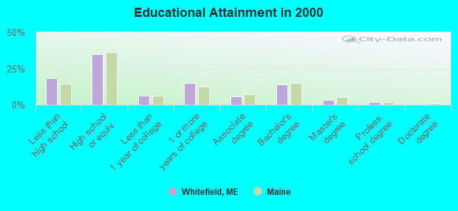
- High school or higher: 81.5%
- Bachelor's degree or higher: 19.6%
- Graduate or professional degree: 5.6%
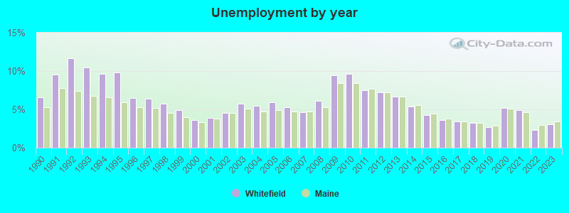
- Unemployed: 5.8%
- Mean travel time to work (commute): 27.5 minutes
| Here: | 10.8 |
| Maine average: | 11.2 |
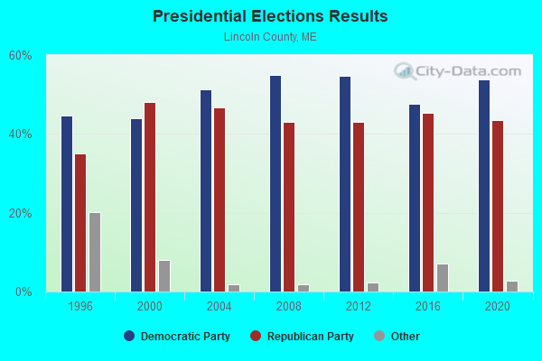
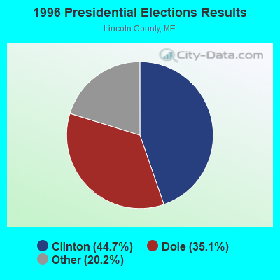
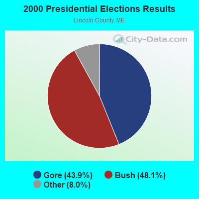


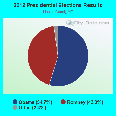

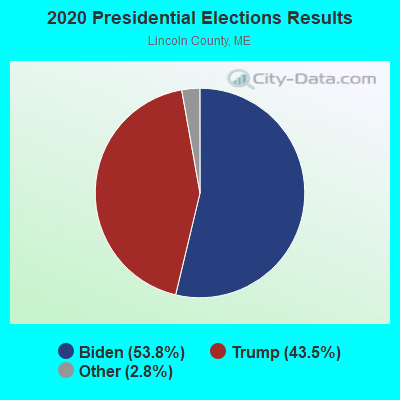
Graphs represent county-level data. Detailed 2008 Election Results
Religion statistics for Whitefield, ME (based on Lincoln County data)
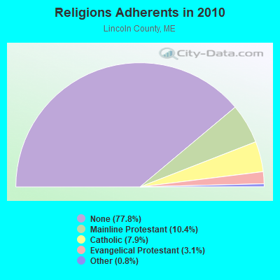

| Religion | Adherents | Congregations |
|---|---|---|
| Mainline Protestant | 3,586 | 29 |
| Catholic | 2,725 | 3 |
| Evangelical Protestant | 1,065 | 12 |
| Other | 279 | 4 |
| None | 26,802 | - |
Food Environment Statistics:
| Lincoln County: | 4.03 / 10,000 pop. |
| Maine: | 2.80 / 10,000 pop. |
| Lincoln County: | 2.59 / 10,000 pop. |
| State: | 2.20 / 10,000 pop. |
| This county: | 6.62 / 10,000 pop. |
| Maine: | 5.75 / 10,000 pop. |
| This county: | 13.23 / 10,000 pop. |
| Maine: | 11.02 / 10,000 pop. |
| Lincoln County: | 7.0% |
| Maine: | 8.2% |
| Lincoln County: | 21.9% |
| State: | 25.0% |
Strongest AM radio stations in Whitefield:
- WFAU (1280 AM; 5 kW; GARDINER, ME; Owner: CAPSTAR TX LIMITED PARTNERSHIP)
- WEZW (1400 AM; 1 kW; AUGUSTA, ME; Owner: CITADEL BROADCASTING COMPANY)
- WSKW (1160 AM; 10 kW; SKOWHEGAN, ME; Owner: MOUNTAIN WIRELESS, INCORPORATED)
- WMDR (1340 AM; 1 kW; AUGUSTA, ME; Owner: LIGHT OF LIFE MINISTRIES, INC.)
- WTME (780 AM; 10 kW; RUMFORD, ME; Owner: MOUNTAIN VALLEY BROADCASTING, INC.)
- WRKO (680 AM; 50 kW; BOSTON, MA; Owner: ENTERCOM BOSTON LICENSE, LLC)
- WMTW (870 AM; 10 kW; GORHAM, ME; Owner: RADIO PARTNERS OF MAINE, L.P.)
- WGAN (560 AM; 5 kW; PORTLAND, ME; Owner: SAGA COMMUNICATIONS OF NEW ENGLAND, LLC)
- WLAM (1470 AM; 5 kW; LEWISTON, ME; Owner: RADIO PARTNERS OF MAINE, L.P.)
- WEEI (850 AM; 50 kW; BOSTON, MA; Owner: ENTERCOM BOSTON LICENSE, LLC)
- WBZ (1030 AM; 50 kW; BOSTON, MA; Owner: INFINITY BROADCASTING OPERATIONS, INC.)
- WZON (620 AM; 5 kW; BANGOR, ME; Owner: THE ZONE CORPORATION)
- WJTO (730 AM; 1 kW; BATH, ME; Owner: BLUE JEY BROADCASTING COMPANY)
Strongest FM radio stations in Whitefield:
- WMME-FM (92.3 FM; AUGUSTA, ME; Owner: CITADEL BROADCASTING COMPANY)
- WMEP (90.5 FM; CAMDEN, ME; Owner: MAINE PUBLIC BROADCASTING CORP.)
- WQSS (102.5 FM; CAMDEN, ME; Owner: CLEAR CHANNEL BROADCASTING LICENSES, INC.)
- WCME (96.7 FM; BOOTHBAY HARBOR, ME; Owner: CAPSTAR TX LIMITED PARTNERSHIP)
- WWWA (95.3 FM; WINSLOW, ME; Owner: LIGHT OF LIFE MINISTRIES, INC.)
- WABK-FM (104.3 FM; GARDINER, ME; Owner: CAPSTAR TX LIMITED PARTNERSHIP)
- WMCM (103.3 FM; ROCKLAND, ME; Owner: CLEAR CHANNEL BROADCASTING LICENSES, INC.)
- WCYI (93.9 FM; LEWISTON, ME; Owner: CITADEL BROADCASTING COMPANY)
- WPKQ (103.7 FM; NORTH CONWAY, NH; Owner: CITADEL BROADCASTING COMPANY)
- WHOM (94.9 FM; MT. WASHINGTON, NH; Owner: CITADEL BROADCASTING COMPANY)
- WBCI (105.9 FM; BATH, ME; Owner: BLOUNT COMMUNICATIONS, INC.)
- WKCG (101.3 FM; AUGUSTA, ME; Owner: CAPSTAR TX LIMITED PARTNERSHIP)
- WBQX (106.9 FM; THOMASTON, ME; Owner: MARINER BROADCASTING LIMITED PARTNER)
- WTOS-FM (105.1 FM; SKOWHEGAN, ME; Owner: CAPSTAR TX LIMITED PARTNERSHIP)
- WWBX (97.1 FM; BANGOR, ME; Owner: CLEAR CHANNEL BROADCASTING LICENSES, INC.)
- WBLM (102.9 FM; PORTLAND, ME; Owner: CITADEL BROADCASTING COMPANY)
- WMEA (90.1 FM; PORTLAND, ME; Owner: MAINE PUBLIC BROADCASTING CORPORATION)
- WFZX (101.7 FM; SEARSPORT, ME; Owner: CLEAR CHANNEL BROADCASTING LICENSES, INC.)
- WBFB (104.7 FM; BELFAST, ME; Owner: CLEAR CHANNEL BROADCASTING LICENSES, INC.)
- WTHT (107.5 FM; LEWISTON, ME; Owner: RADIO PARTNERS OF MAINE, L.P.)
TV broadcast stations around Whitefield:
- WPFO (Channel 23; WATERVILLE, ME; Owner: CMCG PORTLAND LICENSE LLC)
- WCBB (Channel 10; AUGUSTA, ME; Owner: MAINE PUBLIC BROADCASTING CORP.)
- WGME-TV (Channel 13; PORTLAND, ME; Owner: WGME LICENSEE, LLC)
- WFYW-LP (Channel 69; FAIRFIELD/WATERVILLE, ME; Owner: THREE ANGELS BROADCASTING NETWORK, INC.)
- DW23AB (Channel 23; WATERVILLE, ME; Owner: RUSSELL COMMUNICATIONS)
Medal of Honor Recipients
Medal of Honor Recipient born in Whitefield: William Farley.
- National Bridge Inventory (NBI) Statistics
- 3Number of bridges
- 26ft / 8.2mTotal length
- 8,089Total average daily traffic
- 403Total average daily truck traffic
- 11,645Total future (year 2036) average daily traffic
FAA Registered Aircraft: 9 (See the full list of FAA Registered Aircraft in Whitefield)
2004 - 2018 National Fire Incident Reporting System (NFIRS) incidents
- Fire incident types reported to NFIRS in Whitefield, ME
- 9476.4%Structure Fires
- 1814.6%Mobile Property/Vehicle Fires
- 75.7%Outside Fires
- 43.3%Other
 Based on the data from the years 2004 - 2018 the average number of fires per year is 8. The highest number of reported fires - 28 took place in 2015, and the least - 0 in 2008. The data has an increasing trend.
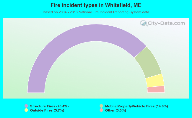 When looking into fire subcategories, the most reports belonged to: Structure Fires (76.4%), and Mobile Property/Vehicle Fires (14.6%).
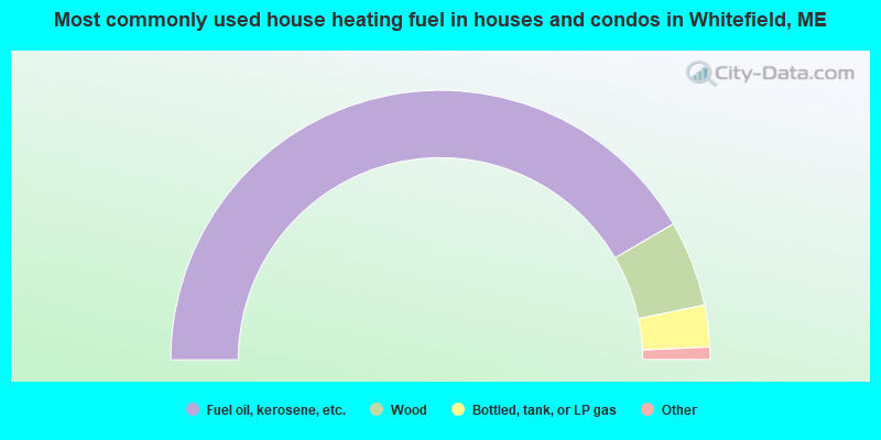
- 83.2%Fuel oil, kerosene, etc.
- 10.3%Wood
- 5.0%Bottled, tank, or LP gas
- 0.9%Electricity
- 0.5%Solar energy
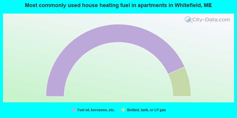
- 86.5%Fuel oil, kerosene, etc.
- 13.5%Bottled, tank, or LP gas
Whitefield compared to Maine state average:
- Unemployed percentage below state average.
- Black race population percentage significantly below state average.
- Hispanic race population percentage below state average.
- Foreign-born population percentage significantly below state average.
- Renting percentage below state average.
- Length of stay since moving in significantly above state average.
- Number of rooms per house significantly below state average.
- House age significantly below state average.

|
Total of 6 patent applications in 2008-2024.