White Oak, Kentucky
Submit your own pictures of this place and show them to the world
- OSM Map
- General Map
- Google Map
- MSN Map

| Males: 1,450 | |
| Females: 1,545 |
| Median resident age: | 36.1 years |
| Kentucky median age: | 35.9 years |
Zip code: 42728
| White Oak: | $39,180 |
| KY: | $59,341 |
Estimated per capita income in 2022: $24,863 (it was $14,030 in 2000)
White Oak CCD income, earnings, and wages data
Estimated median house or condo value in 2022: $131,472 (it was $52,500 in 2000)
| White Oak: | $131,472 |
| KY: | $196,300 |
Mean prices in 2022: all housing units: $169,717; detached houses: $186,335; townhouses or other attached units: $186,093; mobile homes: $69,353; occupied boats, rvs, vans, etc.: $92,599
Detailed information about poverty and poor residents in White Oak, KY


- 2,84598.4%White alone
- 200.7%Two or more races
- 80.3%American Indian alone
- 100.3%Hispanic
- 60.2%Black alone
- 30.1%Other race alone

Races in White Oak detailed stats: ancestries, foreign born residents, place of birth
 Recent articles from our blog. Our writers, many of them Ph.D. graduates or candidates, create easy-to-read articles on a wide variety of topics.
Current Local Time: CST time zone
Land area: 74.2 square miles.
Population density: 40 people per square mile (very low).

| White Oak CCD: | 0.5% ($266) |
| Kentucky: | 0.8% ($610) |
Nearest city with pop. 50,000+: Fayette, KY  (73.4 miles , pop. 260,512).
Nearest city with pop. 1,000,000+: Chicago, IL (353.6 miles , pop. 2,896,016).
Nearest cities:
), ), ), ), ), Latitude: 37.11 N, Longitude: 85.16 W
Area code commonly used in this area: 270


| Here: | 4.7% |
| Kentucky: | 3.8% |

- Agriculture, forestry, fishing & hunting (12.8%)
- Health care (9.9%)
- Educational services (8.9%)
- Construction (8.5%)
- Accommodation & food services (4.6%)
- Apparel (4.4%)
- Public administration (3.9%)

- Agriculture, forestry, fishing & hunting (19.3%)
- Construction (15.3%)
- Repair & maintenance (6.4%)
- Truck transportation (5.2%)
- Metal & metal products (4.9%)
- Wood products (4.9%)
- Public administration (4.0%)

- Health care (20.4%)
- Educational services (15.1%)
- Accommodation & food services (8.4%)
- Apparel (5.6%)
- Agriculture, forestry, fishing & hunting (4.7%)
- Food & beverage stores (4.5%)
- Transportation equipment (3.7%)

- Farmers and farm managers (7.3%)
- Driver/sales workers and truck drivers (6.8%)
- Textile, apparel, and furnishings workers (4.9%)
- Other production occupations, including supervisors (4.6%)
- Vehicle and mobile equipment mechanics, installers, and repairers (4.1%)
- Agricultural workers, including supervisors (3.8%)
- Laborers and material movers, hand (3.3%)

- Driver/sales workers and truck drivers (12.2%)
- Farmers and farm managers (11.0%)
- Vehicle and mobile equipment mechanics, installers, and repairers (7.3%)
- Electrical equipment mechanics and other installation, maintenance, and repair workers, including supervisors (5.4%)
- Agricultural workers, including supervisors (4.5%)
- Laborers and material movers, hand (4.5%)
- Other production occupations, including supervisors (4.5%)

- Health technologists and technicians (6.9%)
- Other office and administrative support workers, including supervisors (6.7%)
- Textile, apparel, and furnishings workers (6.5%)
- Preschool, kindergarten, elementary, and middle school teachers (5.6%)
- Supervisors and other personal care and service workers, except child care workers (5.4%)
- Information and record clerks, except customer service representatives (5.2%)
- Other production occupations, including supervisors (4.7%)
Average climate in White Oak, Kentucky
Based on data reported by over 4,000 weather stations


Tornado activity:
White Oak-area historical tornado activity is near Kentucky state average. It is 38% greater than the overall U.S. average.
On 4/27/1971, a category F4 (max. wind speeds 207-260 mph) tornado 2.4 miles away from the White Oak place center killed 6 people and injured 58 people.
On 4/27/1971, a category F4 tornado 5.6 miles away from the place center killed 2 people and injured 72 people and caused between $500,000 and $5,000,000 in damages.
Earthquake activity:
White Oak-area historical earthquake activity is significantly above Kentucky state average. It is 112% greater than the overall U.S. average.On 7/27/1980 at 18:52:21, a magnitude 5.2 (5.1 MB, 4.7 MS, 5.0 UK, 5.2 UK, Class: Moderate, Intensity: VI - VII) earthquake occurred 101.0 miles away from the city center
On 4/18/2008 at 09:36:59, a magnitude 5.4 (5.1 MB, 4.8 MS, 5.4 MW, 5.2 MW) earthquake occurred 175.3 miles away from White Oak center
On 4/18/2008 at 09:36:59, a magnitude 5.2 (5.2 MW, Depth: 8.9 mi) earthquake occurred 175.3 miles away from White Oak center
On 6/18/2002 at 17:37:15, a magnitude 5.0 (4.3 MB, 4.6 MW, 5.0 LG) earthquake occurred 155.7 miles away from the city center
On 6/10/1987 at 23:48:54, a magnitude 5.1 (4.9 MB, 4.4 MS, 4.6 MS, 5.1 LG) earthquake occurred 189.7 miles away from the city center
On 11/30/1973 at 07:48:41, a magnitude 4.7 (4.7 MB, 4.6 ML, Class: Light, Intensity: IV - V) earthquake occurred 112.7 miles away from the city center
Magnitude types: regional Lg-wave magnitude (LG), body-wave magnitude (MB), local magnitude (ML), surface-wave magnitude (MS), moment magnitude (MW)
Natural disasters:
The number of natural disasters in Adair County (17) is near the US average (15).Major Disasters (Presidential) Declared: 13
Emergencies Declared: 2
Causes of natural disasters: Floods: 9, Storms: 9, Tornadoes: 7, Winds: 4, Mudslides: 3, Winter Storms: 3, Landslides: 2, Blizzard: 1, Freeze: 1, Hurricane: 1, Snow: 1, Snowfall: 1, Snowstorm: 1, Other: 1 (Note: some incidents may be assigned to more than one category).
Colleges/universities with over 2000 students nearest to White Oak:
- Lindsey Wilson College (about 8 miles; Columbia, KY; Full-time enrollment: 2,552)
- Campbellsville University (about 20 miles; Campbellsville, KY; FT enrollment: 2,948)
- Somerset Community College (about 31 miles; Somerset, KY; FT enrollment: 4,698)
- Elizabethtown Community and Technical College (about 57 miles; Elizabethtown, KY; FT enrollment: 3,762)
- University of the Cumberlands (about 62 miles; Williamsburg, KY; FT enrollment: 3,585)
- Eastern Kentucky University (about 65 miles; Richmond, KY; FT enrollment: 13,525)
- Tennessee Technological University (about 68 miles; Cookeville, TN; FT enrollment: 9,761)
Points of interest:
Churches in White Oak include: Free Union Separate Baptist Church (A), Freedom Separater Church (B), Grassy Springs Church (C), Little Cake Christian Church (D), Lovedale Church (E), White Oak Church (F), Millerfield Church (G), New Hope Church (H), Pleasant View Church (I). Display/hide their locations on the map
Cemeteries: Adkins Cemetery (1), Damron Cemetery (2), Williams Cemetery (3). Display/hide their locations on the map
Streams, rivers, and creeks: Big Clifty Creek (A), Denton Branch (B), Damron Creek (C), Taylor Branch (D), Cabin Fork Creek (E), Butler Creek (F), Snake Creek (G), McKee Branch (H), Bryant Creek (I). Display/hide their locations on the map
| This place: | 2.5 people |
| Kentucky: | 2.5 people |
| This place: | 70.4% |
| Whole state: | 66.9% |
| This place: | 6.3% |
| Whole state: | 6.4% |
Likely homosexual households (counted as self-reported same-sex unmarried-partner households)
- Lesbian couples: 0.2% of all households
- Gay men: 0.4% of all households
| This place: | 29.6% |
| Whole state: | 15.8% |
| This place: | 8.4% |
| Whole state: | 6.6% |
For population 15 years and over in White Oak:

- Never married: 17.4%
- Now married: 65.0%
- Separated: 1.8%
- Widowed: 8.3%
- Divorced: 9.4%
For population 25 years and over in White Oak:
- High school or higher: 55.4%
- Bachelor's degree or higher: 5.7%
- Graduate or professional degree: 2.1%
- Unemployed: 5.5%
- Mean travel time to work (commute): 26.0 minutes


| Here: | 14.6 |
| Kentucky average: | 13.8 |
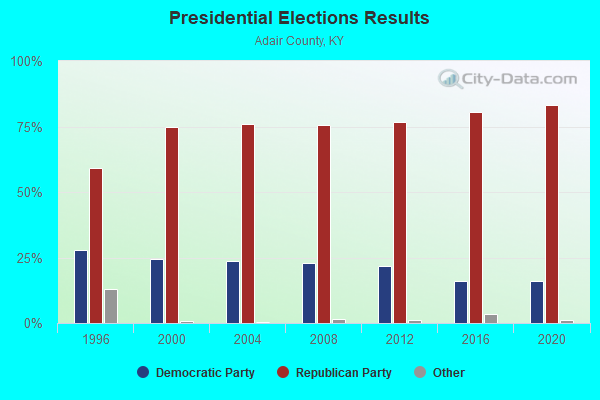
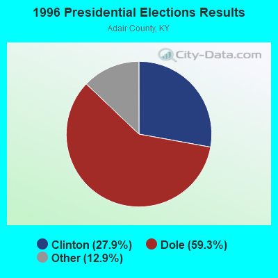
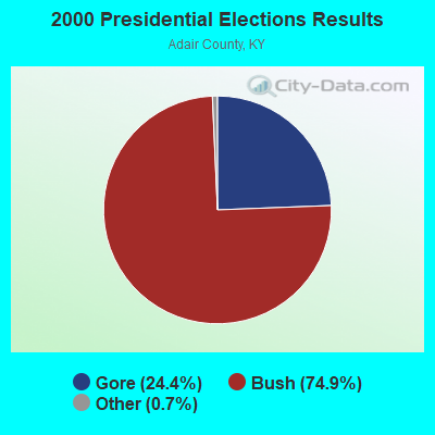
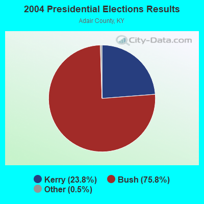
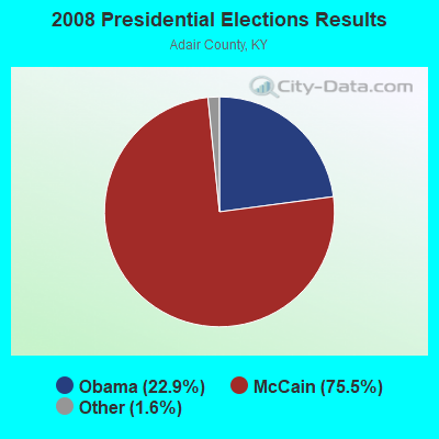
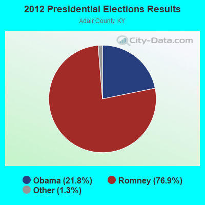
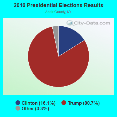
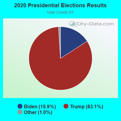
Graphs represent county-level data. Detailed 2008 Election Results
Religion statistics for White Oak, KY (based on Adair County data)
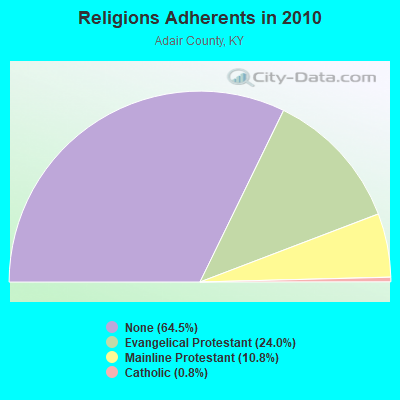
| Religion | Adherents | Congregations |
|---|---|---|
| Evangelical Protestant | 4,478 | 35 |
| Mainline Protestant | 2,011 | 16 |
| Catholic | 140 | 1 |
| Other | 2 | - |
| None | 12,025 | - |
Food Environment Statistics:
| This county: | 3.37 / 10,000 pop. |
| State: | 2.19 / 10,000 pop. |
| This county: | 5.61 / 10,000 pop. |
| State: | 4.36 / 10,000 pop. |
| Here: | 4.49 / 10,000 pop. |
| Kentucky: | 5.74 / 10,000 pop. |
| Adair County: | 12.5% |
| State: | 11.0% |
| Adair County: | 32.2% |
| Kentucky: | 30.0% |
| Adair County: | 15.3% |
| Kentucky: | 15.9% |
Strongest AM radio stations in White Oak:
- WIDS (570 AM; 0 kW; RUSSELL SPRINGS, KY; Owner: HAMMOND BROADCASTING, INC.)
- WAIN (1270 AM; 1 kW; COLUMBIA, KY)
- WJKY (1060 AM; daytime; 1 kW; JAMESTOWN, KY; Owner: LAKE CUMBERLAND BROADCASTERS)
- WHAS (840 AM; 50 kW; LOUISVILLE, KY; Owner: CLEAR CHANNEL BROADCASTING LICENSES, INC.)
- WKVL (850 AM; daytime; 50 kW; KNOXVILLE, TN; Owner: HORNE RADIO, LLC)
- WSM (650 AM; 50 kW; NASHVILLE, TN; Owner: GAYLORD ENTERTAINMENT COMPANY)
- WAMB (1160 AM; 50 kW; DONELSON, TN; Owner: GREAT SOUTHERN BROADCASTING COMPANY, INC.)
- WKDA (1200 AM; 50 kW; NASHVILLE, TN; Owner: RADIO NASHVILLE, INC.)
- WLAC (1510 AM; 50 kW; NASHVILLE, TN; Owner: CAPSTAR TX LIMITED PARTNERSHIP)
- WNQM (1300 AM; 50 kW; NASHVILLE, TN; Owner: WNQM. INC.)
- WWAM (820 AM; daytime; 50 kW; JASPER, TN; Owner: SHELTON BROADCASTING SYSTEM)
- WLW (700 AM; 50 kW; CINCINNATI, OH; Owner: JACOR BROADCASTING CORPORATION)
- WFLI (1070 AM; 50 kW; LOOKOUT MOUNTAIN, TN; Owner: WFLI, INC.)
Strongest FM radio stations in White Oak:
- WDCL-FM (89.7 FM; SOMERSET, KY; Owner: WESTERN KENTUCKY UNIVERSITY)
- WHVE (92.7 FM; RUSSELL SPRINGS, KY; Owner: SHORELINE COMMUNICATIONS, INC)
- WJRS (104.9 FM; JAMESTOWN, KY; Owner: LAKE CUMBERLAND BROADCASTERS)
- WAIN-FM (93.5 FM; COLUMBIA, KY; Owner: TRI-COUNTY RADIO BROADCASTING CORP.)
- WMKZ (93.1 FM; MONTICELLO, KY; Owner: MONTICELLO-WAYNE COUNTY MEDIA, INC.)
- WVLC (99.9 FM; MANNSVILLE, KY; Owner: PATRICIA RODGERS)
- WCKQ (104.1 FM; CAMPBELLSVILLE, KY; Owner: CBC OF MARION & TAYLOR COUNTIES INC)
- WKYM (101.7 FM; MONTICELLO, KY; Owner: STEPHEN W. STAPLES JR.)
- WXKY-FM (96.3 FM; STANFORD, KY; Owner: LINCOLN-GARRARD BROADCASTING CO.,INC)
- WSEK (97.1 FM; SOMERSET, KY; Owner: CAPSTAR TX LIMITED PARTNERSHIP)
- WGRK-FM (103.1 FM; GREENSBURG, KY; Owner: GREEN COUNTY CBC, INC.)
- WTHL (90.5 FM; SOMERSET, KY; Owner: SOMERSET EDUCATIONAL BROADCASTING FOUNDATION)
- WKNK (99.1 FM; EDMONTON, KY; Owner: HART COUNTY COMMUNICATIONS, INC.)
- WKDO-FM (98.7 FM; LIBERTY, KY; Owner: CARLOS D. WESLEY)
- WAPD (91.7 FM; CAMPBELLSVILLE, KY; Owner: AMERICAN FAMILY ASSOCIATION)
- WKYR-FM (107.9 FM; BURKESVILLE, KY; Owner: RAY MULLINIX)
TV broadcast stations around White Oak:
- WKSO-TV (Channel 29; SOMERSET, KY; Owner: KENTUCKY AUTHORITY FOR EDUCATIONAL TV)
- WBKI-TV (Channel 34; CAMPBELLSVILLE, KY; Owner: LOUISVILLE COMMUNICATIONS, LLC)
- W04BP (Channel 4; CAMPBELLSVILLE, KY; Owner: CAMPSVILLE UNIVERSITY)
FCC Registered Antenna Towers:
5- Daniel J Turnpaugh, Spring Branch Road (Lat: 37.833306 Lon: -83.173611), Type: 60.7, Overall height: 52.7 m, Registrant: Dukenet Communication Services LLC, Dan.Turnpaugh@duke-Energy.Com, , Cinci-nnati, Phone: (513) 419-5046
- Daniel J Turnpaugh, Spring Branch Road (Lat: 37.833306 Lon: -83.173611), Type: 60.7, Overall height: 52.7 m, Registrant: Dukenet Communication Services LLC, Dan.Turnpaugh@duke-Energy.Com, , Cinci-nnati, Phone: (513) 419-5046
- Daniel J Turnpaugh, Spring Branch Road (Lat: 37.833306 Lon: -83.173611), Type: 60.7, Overall height: 52.7 m, Registrant: Dukenet Communication Services LLC, Kathy.Smith@duke-Energy.Com, , Cinci-nnati, Phone: (513) 287-5672
- Leslie N Nixon, Spring Branch Road (Lat: 37.833306 Lon: -83.173611), Type: 60.7, Overall height: 52.7 m, Registrant: Global Tower, LLC, Fcc-Contact@gtpsites.Com, , Boca -Raton, Phone: (561) 995-0320
- Kristen Cesana, Spring Branch Road (Lat: 37.833306 Lon: -83.173611), Type: 60.7, Structure height: 21175 m, Overall height: 52.7 m, Registrant: Global Tower, LLC, Fcc-Contact@gtpsites.Com, , Boca -Raton, Phone: (561) 995-0320
FCC Registered Microwave Towers:
3- 9LV3244A, Spring Branch Road (Lat: 37.833306 Lon: -83.173611), Type: Gtower, Structure height: 52.7 m, Overall height: 60.7 m, Call Sign: WRAE399,
Assigned Frequencies: 10855.0 MHz, 10855.0 MHz, 10855.0 MHz, 10855.0 MHz, 10855.0 MHz, 10855.0 MHz, 10855.0 MHz, 10855.0 MHz, Grant Date: 10/24/2017, Expiration Date: 10/24/2027, Cancellation Date: 08/26/2020, Certifier: David Weblow, Registrant: T-Mobile Usa, Inc., 12920 Se 38th Street, Bellevue, WA 98006, Phone: (425) 383-8401, Fax: (425) 383-4040, Email:
- 9LV3244A, Spring Branch Road (Lat: 37.833306 Lon: -83.173611), Type: Ltower, Structure height: 52.7 m, Overall height: 60.7 m, Call Sign: WRAK326,
Assigned Frequencies: 11545.0 MHz, 11545.0 MHz, 11545.0 MHz, 11545.0 MHz, 11545.0 MHz, 11545.0 MHz, 11545.0 MHz, 11545.0 MHz, Grant Date: 12/12/2017, Expiration Date: 12/12/2027, Cancellation Date: 10/09/2018, Certifier: David Werblow, Registrant: T-Mobile Usa, Inc., 12920 Se 38th Street, Bellevue, WA 98006, Phone: (425) 383-8401, Fax: (425) 383-4040, Email:
- 9LV3244A, Spring Branch Road (Lat: 37.833306 Lon: -83.173611), Type: Gtower, Structure height: 52.7 m, Overall height: 60.7 m, Call Sign: WRAX609,
Assigned Frequencies: 11645.0 MHz, 11645.0 MHz, 11645.0 MHz, 11645.0 MHz, 11645.0 MHz, 11645.0 MHz, 11645.0 MHz, 11645.0 MHz, 11645.0 MHz, 11645.0 MHz... (+47 more), Grant Date: 04/03/2018, Expiration Date: 04/03/2028, Certifier: David Werblow, Registrant: T-Mobile Usa, Inc., 12920 Se 38th Street, Bellevue, WA 98006, Phone: (425) 383-8401, Fax: (425) 383-4040, Email:

- 54.0%Electricity
- 19.7%Wood
- 12.9%Bottled, tank, or LP gas
- 12.1%Fuel oil, kerosene, etc.
- 1.4%No fuel used

- 43.9%Electricity
- 26.6%Wood
- 17.3%Fuel oil, kerosene, etc.
- 8.1%Bottled, tank, or LP gas
- 4.0%Utility gas
White Oak compared to Kentucky state average:
- Median household income below state average.
- Unemployed percentage below state average.
- Black race population percentage significantly below state average.
- Hispanic race population percentage significantly below state average.
- Median age below state average.
- Foreign-born population percentage significantly below state average.
- Renting percentage below state average.
- Length of stay since moving in significantly above state average.
- Number of rooms per house significantly below state average.
- House age significantly below state average.
- Percentage of population with a bachelor's degree or higher significantly below state average.