West Springs, South Carolina
Submit your own pictures of this place and show them to the world
- OSM Map
- General Map
- Google Map
- MSN Map

| Males: 911 | |
| Females: 931 |
| Median resident age: | 38.1 years |
| South Carolina median age: | 35.4 years |
Zip code: 29321
| West Springs: | $55,145 |
| SC: | $64,115 |
Estimated per capita income in 2022: $28,325 (it was $16,940 in 2000)
West Springs CCD income, earnings, and wages data
Estimated median house or condo value in 2022: $132,649 (it was $66,900 in 2000)
| West Springs: | $132,649 |
| SC: | $254,600 |
Detailed information about poverty and poor residents in West Springs, SC


- 1,71486.3%White alone
- 26713.4%Black alone
- 30.2%Two or more races
- 30.2%Hispanic

Races in West Springs detailed stats: ancestries, foreign born residents, place of birth
 Recent articles from our blog. Our writers, many of them Ph.D. graduates or candidates, create easy-to-read articles on a wide variety of topics.

Current Local Time: EST time zone
Elevation: 711 feet
Land area: 63.2 square miles.
Population density: 29 people per square mile (very low).

| West Springs CCD: | 0.5% ($353) |
| South Carolina: | 0.6% ($510) |
Nearest city with pop. 50,000+: Greenville, SC  (36.6 miles , pop. 56,002).
Nearest city with pop. 200,000+: Charlotte, NC (62.0 miles , pop. 540,828).
Nearest city with pop. 1,000,000+: Philadelphia, PA (514.3 miles , pop. 1,517,550).
Nearest cities:
), ), ), ), )Latitude: 34.73 N, Longitude: 81.76 W
Area code commonly used in this area: 864


| Here: | 3.9% |
| South Carolina: | 3.1% |

- Textile mills & textile products (12.7%)
- Health care (10.4%)
- Metal & metal products (9.1%)
- Educational services (6.2%)
- Construction (5.8%)
- Plastics & rubber products (4.4%)
- Food & beverage stores (3.2%)

- Metal & metal products (12.7%)
- Textile mills & textile products (11.1%)
- Construction (10.4%)
- Plastics & rubber products (6.7%)
- Motor vehicle & parts dealers (4.6%)
- Food & beverage stores (4.2%)
- Transportation equipment (4.0%)

- Health care (19.2%)
- Textile mills & textile products (14.2%)
- Educational services (11.7%)
- Metal & metal products (5.7%)
- Public administration (3.8%)
- Miscellaneous manufacturing (2.8%)
- Jewelry, luggage, leather goods stores (2.5%)

- Electrical equipment mechanics and other installation, maintenance, and repair workers, including supervisors (8.6%)
- Other production occupations, including supervisors (7.7%)
- Metal workers and plastic workers (7.3%)
- Retail sales workers, except cashiers (7.2%)
- Other sales and related occupations, including supervisors (5.1%)
- Textile, apparel, and furnishings workers (4.5%)
- Material recording, scheduling, dispatching, and distributing workers (3.5%)

- Electrical equipment mechanics and other installation, maintenance, and repair workers, including supervisors (15.2%)
- Metal workers and plastic workers (12.7%)
- Other sales and related occupations, including supervisors (6.5%)
- Retail sales workers, except cashiers (6.0%)
- Other production occupations, including supervisors (5.8%)
- Material recording, scheduling, dispatching, and distributing workers (4.6%)
- Driver/sales workers and truck drivers (3.8%)

- Other production occupations, including supervisors (9.6%)
- Retail sales workers, except cashiers (8.5%)
- Health technologists and technicians (6.6%)
- Other office and administrative support workers, including supervisors (6.2%)
- Textile, apparel, and furnishings workers (5.8%)
- Secretaries and administrative assistants (4.7%)
- Counselors, social workers, and other community and social service specialists (4.0%)
Average climate in West Springs, South Carolina
Based on data reported by over 4,000 weather stations


(lower is better)

Air Quality Index (AQI) level in 2007 was 76.4. This is about average.
| City: | 76.4 |
| U.S.: | 72.6 |

Ozone [ppb] level in 2007 was 28.3. This is about average. Closest monitor was 17.3 miles away from the city center.
| City: | 28.3 |
| U.S.: | 33.3 |

Lead (Pb) [µg/m3] level in 2007 was 0.00000. This is significantly better than average. Closest monitor was 15.7 miles away from the city center.
| City: | 0.00000 |
| U.S.: | 0.00931 |
Tornado activity:
West Springs-area historical tornado activity is slightly above South Carolina state average. It is 20% greater than the overall U.S. average.
On 5/5/1989, a category F4 (max. wind speeds 207-260 mph) tornado 26.1 miles away from the West Springs place center killed 2 people and injured 35 people and caused between $500,000 and $5,000,000 in damages.
On 5/10/1952, a category F3 (max. wind speeds 158-206 mph) tornado 7.2 miles away from the place center killed 2 people and injured 4 people.
Earthquake activity:
West Springs-area historical earthquake activity is significantly above South Carolina state average. It is 3% smaller than the overall U.S. average.On 8/2/1974 at 08:52:09, a magnitude 4.9 (4.3 MB, 4.9 LG, Class: Light, Intensity: IV - V) earthquake occurred 72.7 miles away from West Springs center
On 8/9/2020 at 12:07:37, a magnitude 5.1 (5.1 MW, Depth: 4.7 mi, Class: Moderate, Intensity: VI - VII) earthquake occurred 126.2 miles away from West Springs center
On 8/23/2011 at 17:51:04, a magnitude 5.8 (5.8 MW, Depth: 3.7 mi) earthquake occurred 305.9 miles away from the city center
On 11/30/1973 at 07:48:41, a magnitude 4.7 (4.7 MB, 4.6 ML) earthquake occurred 144.8 miles away from West Springs center
On 11/22/1974 at 05:25:55, a magnitude 4.7 (4.7 MB) earthquake occurred 156.9 miles away from the city center
On 7/27/1980 at 18:52:21, a magnitude 5.2 (5.1 MB, 4.7 MS, 5.0 UK, 5.2 UK) earthquake occurred 269.3 miles away from West Springs center
Magnitude types: regional Lg-wave magnitude (LG), body-wave magnitude (MB), local magnitude (ML), surface-wave magnitude (MS), moment magnitude (MW)
Natural disasters:
The number of natural disasters in Union County (11) is smaller than the US average (15).Major Disasters (Presidential) Declared: 4
Emergencies Declared: 5
Causes of natural disasters: Hurricanes: 3, Floods: 2, Ice Storms: 2, Storms: 2, Winter Storms: 2, Drought: 1, Other: 1 (Note: some incidents may be assigned to more than one category).
Hospitals and medical centers near West Springs:
- OAKMONT OF UNION (Nursing Home, about 7 miles away; UNION, SC)
- WEST MAIN ST COMMUNITY RESIDEN (Hospital, about 7 miles away; UNION, SC)
- ELLEN SAGAR NURSING HOME (Nursing Home, about 8 miles away; UNION, SC)
- DCI UNION (Dialysis Facility, about 8 miles away; UNION, SC)
- WALLACE THOMSON HOSPITAL Acute Care Hospitals (about 8 miles away; UNION, SC)
- MOUNTAINVIEW NURSING HOME (Nursing Home, about 15 miles away; SPARTANBURG, SC)
- WOODRUFF MANOR, LLC (Nursing Home, about 16 miles away; WOODRUFF, SC)
Colleges/universities with over 2000 students nearest to West Springs:
- Spartanburg Community College (about 22 miles; Spartanburg, SC; Full-time enrollment: 4,309)
- University of South Carolina-Upstate (about 23 miles; Spartanburg, SC; FT enrollment: 4,994)
- Limestone College (about 24 miles; Gaffney, SC; FT enrollment: 2,758)
- Greenville Technical College (about 36 miles; Greenville, SC; FT enrollment: 9,859)
- Bob Jones University (about 36 miles; Greenville, SC; FT enrollment: 3,308)
- Gardner-Webb University (about 37 miles; Boiling Springs, NC; FT enrollment: 4,241)
- Cleveland Community College (about 41 miles; Shelby, NC; FT enrollment: 2,541)
Points of interest:
Notable locations in West Springs: Fair Forest Hunt Camp (A), Fair Forest Rifle Range (B). Display/hide their locations on the map
Churches in West Springs include: Mount Lebanon Baptist Church (A), Bogansville Methodist Church (B), Jacobs Chapel (C), Lower Fairforest Baptist Church (D), Wyatts Chapel (E), Sulphur Springs Baptist Church (F), Thompson Church (G), West Springs Baptist Church (H), Rices Chapel (I). Display/hide their locations on the map
Cemeteries: Mount Lebanon Cemetery (1), Bogansville Cemetery (2), Gibbs Cemetery (3), Holcombe Cemetery (4), Lawson Cemetery (5), Lower Fairforest Cemetery (6), Mayhew Cemetery (7). Display/hide their locations on the map
Lake: Maple Pond (A). Display/hide its location on the map
Streams, rivers, and creeks: Dutchman Creek (A), West Springs Branch (B), Swink Creek (C), Mitchell Creek (D), Holcombe Branch (E), Dining Creek (F). Display/hide their locations on the map
Park in West Springs: Calhoun Experimental Forest (1). Display/hide its location on the map
| This place: | 2.5 people |
| South Carolina: | 2.5 people |
| This place: | 75.5% |
| Whole state: | 67.5% |
| This place: | 5.0% |
| Whole state: | 6.0% |
Likely homosexual households (counted as self-reported same-sex unmarried-partner households)
- Lesbian couples: 0.6% of all households
- Gay men: 0.2% of all households
| This place: | 5.4% |
| Whole state: | 14.1% |
| This place: | 0.6% |
| Whole state: | 6.5% |
9 people in homes for the mentally retarded in 2000
For population 15 years and over in West Springs:

- Never married: 18.4%
- Now married: 69.4%
- Separated: 1.4%
- Widowed: 4.3%
- Divorced: 7.9%
For population 25 years and over in West Springs:
- High school or higher: 78.7%
- Bachelor's degree or higher: 11.3%
- Graduate or professional degree: 3.5%
- Unemployed: 4.2%
- Mean travel time to work (commute): 26.7 minutes


| Here: | 11.1 |
| South Carolina average: | 13.2 |
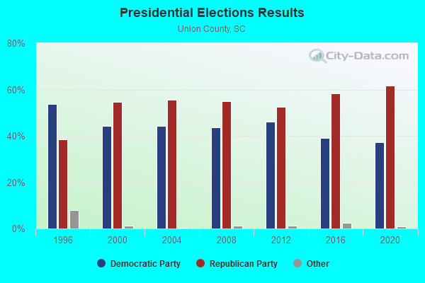
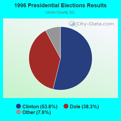
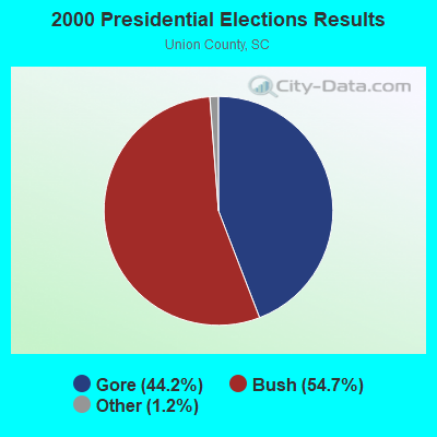
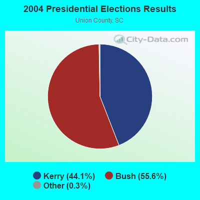
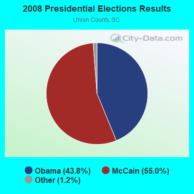
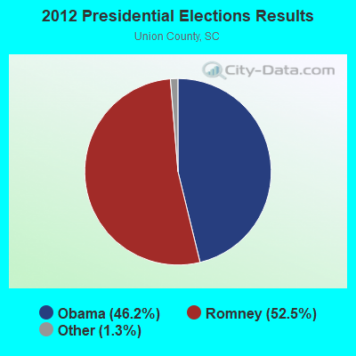
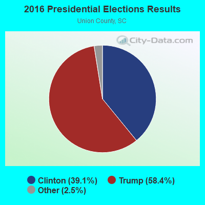
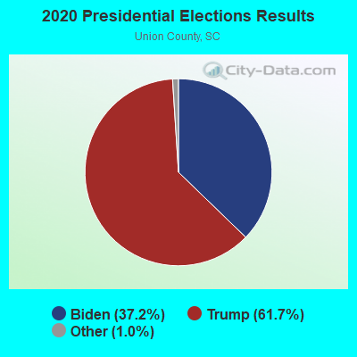
Graphs represent county-level data. Detailed 2008 Election Results
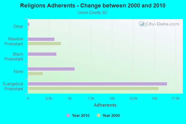
Religion statistics for West Springs, SC (based on Union County data)
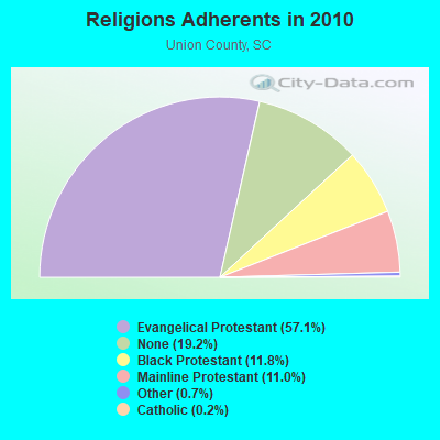
| Religion | Adherents | Congregations |
|---|---|---|
| Evangelical Protestant | 16,533 | 50 |
| Black Protestant | 3,424 | 19 |
| Mainline Protestant | 3,180 | 20 |
| Other | 210 | 1 |
| Catholic | 50 | 1 |
| None | 5,564 | - |
Food Environment Statistics:
| Here: | 2.16 / 10,000 pop. |
| South Carolina: | 1.99 / 10,000 pop. |
| Union County: | 1.08 / 10,000 pop. |
| South Carolina: | 0.85 / 10,000 pop. |
| This county: | 7.92 / 10,000 pop. |
| South Carolina: | 5.38 / 10,000 pop. |
| This county: | 5.04 / 10,000 pop. |
| South Carolina: | 7.75 / 10,000 pop. |
| Union County: | 12.2% |
| South Carolina: | 10.6% |
| Union County: | 32.1% |
| State: | 29.4% |
| This county: | 12.5% |
| South Carolina: | 13.4% |
Strongest AM radio stations in West Springs:
- WBCU (1460 AM; 50 kW; UNION, SC)
- WLFJ (660 AM; daytime; 50 kW; GREENVILLE, SC; Owner: CLEAR CHANNEL BROADCASTING LICENSES, INC.)
- WCSZ (1070 AM; 50 kW; SANS SOUCI, SC; Owner: WHYZ RADIO, L.P.)
- WBAJ (890 AM; daytime; 50 kW; BLYTHEWOOD, SC; Owner: FAMILY FIRST)
- WCEO (840 AM; daytime; 50 kW; COLUMBIA, SC; Owner: EASTERN BROADCASTING GROUP, INC.)
- WBT (1110 AM; 50 kW; CHARLOTTE, NC; Owner: JEFFERSON-PILOT COMMUNICATNS CO. OF NORTH CAROLINA)
- WAGL (1560 AM; daytime; 50 kW; LANCASTER, SC; Owner: PALMETTO BROADCASTING SYSTEM, INC.)
- WORD (950 AM; 5 kW; SPARTANBURG, SC; Owner: ENTERCOM GREENVILLE LICENSE, LLC)
- WFGW (1010 AM; 50 kW; BLACK MOUNTAIN, NC; Owner: BLUE RIDGE BROADCASTING CORP.)
- WHKY (1290 AM; 50 kW; HICKORY, NC; Owner: LONG COMMUNICATIONS, LLC.)
- WWOL (780 AM; daytime; 10 kW; FOREST CITY, NC; Owner: HOLLY SPRINGS BAPTIST BROADCASTING CO., INC.)
- WSPA (910 AM; 4 kW; SPARTANBURG, SC; Owner: ENTERCOM GREENVILLE LICENSE, LLC)
- WLTC (1370 AM; 20 kW; GASTONIA, NC)
Strongest FM radio stations in West Springs:
- WSSL-FM (100.5 FM; GRAY COURT, SC; Owner: CAPSTAR TX LIMITED PARTNERSHIP)
- WROQ (101.1 FM; ANDERSON, SC; Owner: OBC BROADCASTING, INC.)
- WSPA-FM (98.9 FM; SPARTANBURG, SC; Owner: ENTERCOM GREENVILLE LICENSE, LLC)
- WFBC-FM (93.7 FM; GREENVILLE, SC; Owner: ENTERCOM GREENVILLE LICENSE, LLC)
- WTPT (93.3 FM; FOREST CITY, NC; Owner: UPSTATE BROADCASTING, LLC)
- WMIT (106.9 FM; BLACK MOUNTAIN, NC; Owner: BLUE RIDGE BROADCASTING CORPORATION)
- WNCW (88.7 FM; SPINDALE, NC; Owner: ISOTHERMAL COMMUNITY COLLEGE)
- WESC-FM (92.5 FM; GREENVILLE, SC; Owner: CLEAR CHANNEL BROADCASTING LICENSES, INC.)
- WBAV-FM (101.9 FM; GASTONIA, NC; Owner: INFINITY RADIO SUBSIDIARY OPERATIONS INC.)
- WMUU-FM (94.5 FM; GREENVILLE, SC; Owner: WMUU, INC.)
- WAGI-FM (105.3 FM; GAFFNEY, SC; Owner: GAFFNEY BROADCASTING, INC.)
- WEPR (90.1 FM; GREENVILLE, SC; Owner: SOUTH CAROLINA EDUCATIONAL TV COMMISSION)
- WLNK (107.9 FM; CHARLOTTE, NC; Owner: JEFFERSON-PILOT COMMUNICATIONS COMPANY OF NORTH CAROLINA)
- WMYI (102.5 FM; HENDERSONVILLE, NC; Owner: CAPSTAR TX LIMITED PARTNERSHIP)
- WLFJ-FM (89.3 FM; GREENVILLE, SC; Owner: RADIO TRAINING NETWORK, INC.)
- WWMG (96.1 FM; SHELBY, NC; Owner: CLEAR CHANNEL BROADCASTING LICENSES, INC.)
- WPEG (97.9 FM; CONCORD, NC; Owner: INFINITY RADIO SUBSIDIARY OPERATIONS INC.)
- W219CH (91.7 FM; LOWRYS, SC; Owner: RICHBURG EDUCATIONAL BROADCASTERS, INC.)
- WNKS (95.1 FM; CHARLOTTE, NC; Owner: INFINITY RADIO SUBSIDIARY OPERATIONS INC.)
- WBZT-FM (96.7 FM; MAULDIN, SC; Owner: CLEAR CHANNEL BROADCASTING LICENSES, INC.)
TV broadcast stations around West Springs:
- WRET-TV (Channel 49; SPARTANBURG, SC; Owner: SOUTH CAROLINA EDUCATIONAL TV COMMISSION)
- WSQY-LP (Channel 66; SPARTANBURG, SC; Owner: ASHEVILLE MEDIA GROUP, LLC)
- WBTV (Channel 3; CHARLOTTE, NC; Owner: JEFFERSON-PILOT COMMUNICATIONS/WBTV, INC.)
- WBSC-TV (Channel 40; ANDERSON, SC; Owner: ANDERSON (WFBC-TV) LICENSEE, INC.)
- WCNC-TV (Channel 36; CHARLOTTE, NC; Owner: WCNC-TV, INC.)
- WJZY (Channel 46; BELMONT, NC; Owner: WJZY-TV, INC.)
- WWWB (Channel 55; ROCK HILL, SC; Owner: WWWB-TV, INC.)
- WNEH (Channel 38; GREENWOOD, SC; Owner: SOUTH CAROLINA EDUCATIONAL TV COMMISSION)

- 58.9%Electricity
- 18.2%Bottled, tank, or LP gas
- 11.1%Fuel oil, kerosene, etc.
- 7.1%Utility gas
- 3.6%Wood
- 1.1%No fuel used

- 47.5%Electricity
- 31.7%Fuel oil, kerosene, etc.
- 10.8%Bottled, tank, or LP gas
- 10.0%Wood
West Springs compared to South Carolina state average:
- Median house value below state average.
- Unemployed percentage significantly below state average.
- Black race population percentage below state average.
- Hispanic race population percentage significantly below state average.
- Foreign-born population percentage significantly below state average.
- Renting percentage significantly below state average.
- Length of stay since moving in significantly above state average.
- Number of rooms per house significantly below state average.
- House age significantly below state average.
- Percentage of population with a bachelor's degree or higher below state average.