West End, Montana
Submit your own pictures of this place and show them to the world
- OSM Map
- General Map
- Google Map
- MSN Map

| Males: 568 | |
| Females: 527 |
| Median resident age: | 41.5 years |
| Montana median age: | 37.5 years |
Zip code: 59867
| West End: | $54,273 |
| MT: | $67,631 |
Estimated per capita income in 2022: $34,754 (it was $15,796 in 2000)
West End CCD income, earnings, and wages data
Estimated median house or condo value in 2022: $328,866 (it was $86,900 in 2000)
| West End: | $328,866 |
| MT: | $366,400 |
Detailed information about poverty and poor residents in West End, MT


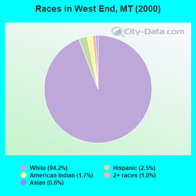
- 1,03394.2%White alone
- 272.5%Hispanic
- 191.7%American Indian alone
- 111.0%Two or more races
- 70.6%Asian alone
Races in West End detailed stats: ancestries, foreign born residents, place of birth
 Recent articles from our blog. Our writers, many of them Ph.D. graduates or candidates, create easy-to-read articles on a wide variety of topics.
Current Local Time: MST time zone
Elevation: 5541 feet
Land area: 446.9 square miles.
Population density: 2.5 people per square mile (very low).

| West End CCD: | 1.0% ($832) |
| Montana: | 1.3% ($1,212) |
Nearest city with pop. 50,000+: Missoula, MT  (69.5 miles , pop. 57,053).
Nearest city with pop. 200,000+: East Seattle, WA (321.5 miles , pop. 480,100).
Nearest city with pop. 1,000,000+: Los Angeles, CA (931.7 miles , pop. 3,694,820).
Nearest cities:
Latitude: 47.36 N, Longitude: 115.30 W
Area code commonly used in this area: 406

| Here: | 6.6% |
| Montana: | 3.8% |
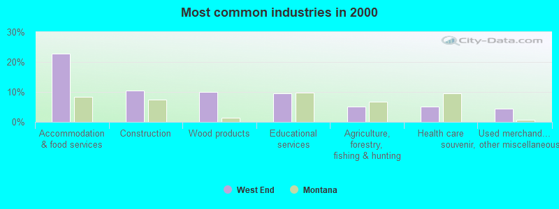
- Accommodation & food services (22.7%)
- Construction (10.5%)
- Wood products (10.0%)
- Educational services (9.6%)
- Agriculture, forestry, fishing & hunting (5.0%)
- Health care (5.0%)
- Used merchandise, gift, novelty, souvenir, other miscellaneous stores (4.4%)
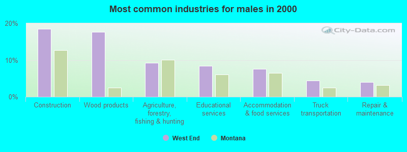
- Construction (18.5%)
- Wood products (17.7%)
- Agriculture, forestry, fishing & hunting (9.2%)
- Educational services (8.4%)
- Accommodation & food services (7.6%)
- Truck transportation (4.4%)
- Repair & maintenance (4.0%)
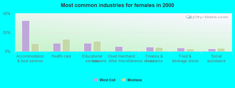
- Accommodation & food services (40.7%)
- Health care (11.0%)
- Educational services (11.0%)
- Used merchandise, gift, novelty, souvenir, other miscellaneous stores (6.7%)
- Finance & insurance (5.7%)
- Food & beverage stores (4.8%)
- Social assistance (3.3%)
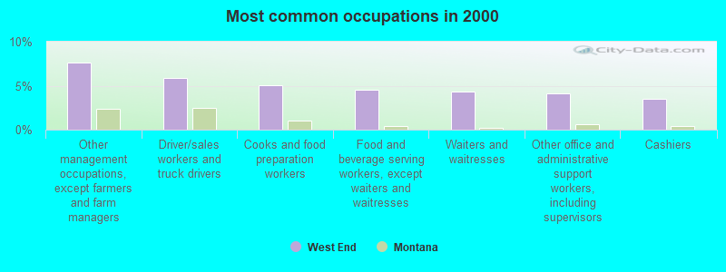
- Other management occupations, except farmers and farm managers (7.6%)
- Driver/sales workers and truck drivers (5.9%)
- Cooks and food preparation workers (5.0%)
- Food and beverage serving workers, except waiters and waitresses (4.6%)
- Waiters and waitresses (4.4%)
- Other office and administrative support workers, including supervisors (4.1%)
- Cashiers (3.5%)
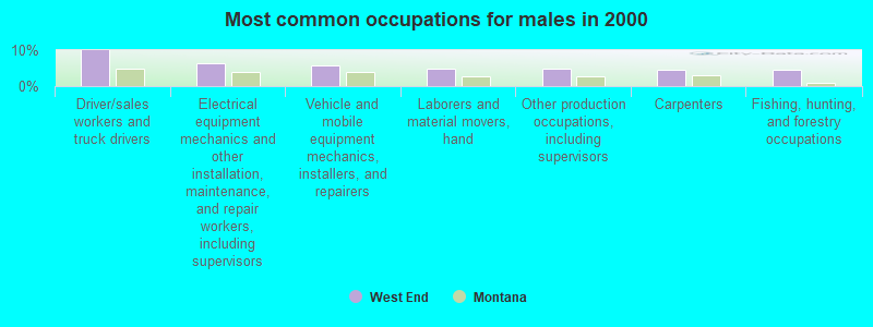
- Driver/sales workers and truck drivers (10.0%)
- Electrical equipment mechanics and other installation, maintenance, and repair workers, including supervisors (6.4%)
- Vehicle and mobile equipment mechanics, installers, and repairers (5.6%)
- Laborers and material movers, hand (4.8%)
- Other production occupations, including supervisors (4.8%)
- Carpenters (4.4%)
- Fishing, hunting, and forestry occupations (4.4%)
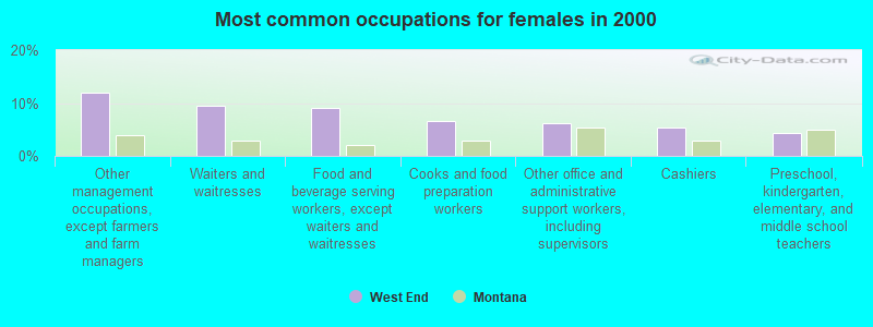
- Other management occupations, except farmers and farm managers (12.0%)
- Waiters and waitresses (9.6%)
- Food and beverage serving workers, except waiters and waitresses (9.1%)
- Cooks and food preparation workers (6.7%)
- Other office and administrative support workers, including supervisors (6.2%)
- Cashiers (5.3%)
- Preschool, kindergarten, elementary, and middle school teachers (4.3%)
Average climate in West End, Montana
Based on data reported by over 4,000 weather stations


(lower is better)
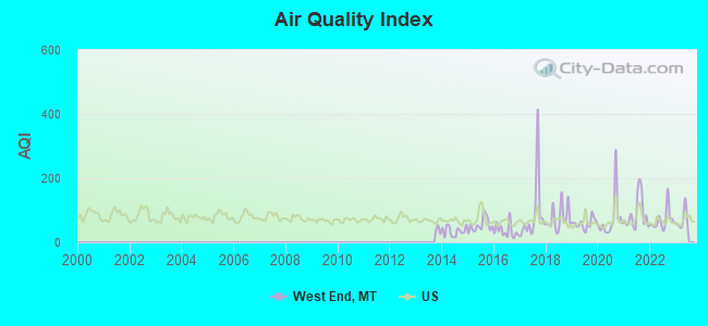
Air Quality Index (AQI) level in 2022 was 68.8. This is about average.
| City: | 68.8 |
| U.S.: | 72.6 |
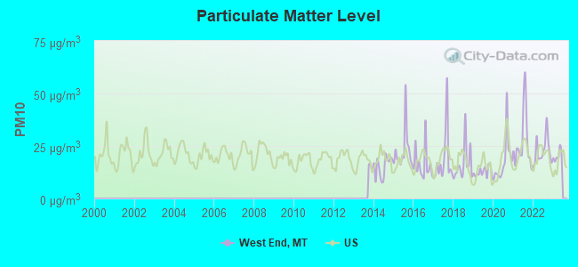
Particulate Matter (PM10) [µg/m3] level in 2022 was 22.6. This is about average. Closest monitor was 16.5 miles away from the city center.
| City: | 22.6 |
| U.S.: | 19.2 |
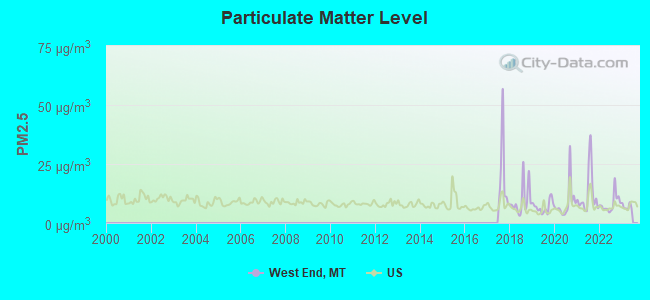
Particulate Matter (PM2.5) [µg/m3] level in 2022 was 8.19. This is about average. Closest monitor was 16.5 miles away from the city center.
| City: | 8.19 |
| U.S.: | 8.11 |
Earthquake activity:
West End-area historical earthquake activity is significantly above Montana state average. It is 902% greater than the overall U.S. average.On 8/18/1959 at 06:37:13, a magnitude 7.7 (7.7 UK, Class: Major, Intensity: VIII - XII) earthquake occurred 294.9 miles away from West End center, causing $26,000,000 total damage
On 10/28/1983 at 14:06:06, a magnitude 7.3 (6.2 MB, 7.3 MS, 7.0 MW) earthquake occurred 238.0 miles away from West End center, causing 2 deaths (2 shaking deaths) and 3 injuries, causing $15,000,000 total damage
On 3/31/2020 at 23:52:30, a magnitude 6.5 (6.5 MW, Depth: 7.5 mi, Class: Strong, Intensity: VII - IX) earthquake occurred 200.2 miles away from West End center
On 4/13/1949 at 19:55:42, a magnitude 7.0 (7.0 UK) earthquake occurred 337.8 miles away from the city center, causing $80,000,000 total damage
On 7/6/2017 at 06:30:17, a magnitude 5.8 (5.8 MW, Depth: 7.6 mi, Class: Moderate, Intensity: VI - VII) earthquake occurred 132.2 miles away from the city center
On 10/3/1915 at 06:52:48, a magnitude 7.6 (7.6 UK) earthquake occurred 486.7 miles away from the city center
Magnitude types: body-wave magnitude (MB), surface-wave magnitude (MS), moment magnitude (MW)
Natural disasters:
The number of natural disasters in Mineral County (7) is smaller than the US average (15).Major Disasters (Presidential) Declared: 3
Emergencies Declared: 1
Causes of natural disasters: Fires: 3, Floods: 2, Storms: 2, Hurricane: 1, Landslide: 1, Other: 1 (Note: some incidents may be assigned to more than one category).
Colleges/universities with over 2000 students nearest to West End:
- The University of Montana (about 71 miles; Missoula, MT; Full-time enrollment: 13,602)
- North Idaho College (about 74 miles; Coeur d'Alene, ID; FT enrollment: 4,684)
- University of Idaho (about 93 miles; Moscow, ID; FT enrollment: 10,416)
- Washington State University (about 98 miles; Pullman, WA; FT enrollment: 25,055)
- Spokane Community College (about 99 miles; Spokane, WA; FT enrollment: 6,482)
- Gonzaga University (about 101 miles; Spokane, WA; FT enrollment: 6,780)
- Whitworth University (about 103 miles; Spokane, WA; FT enrollment: 2,689)
Points of interest:
Notable locations in West End: Ward Cabin (A), Little Joe Lookout Station (B), Saltese Rest Area (C), Silver Dollar Inn Campground (D), Campground Saint Regis (E), Trestle Creek Golf Club (F), Saint Regis KOA Kampgrounds (G), Saint Regis Riding Stables Campground (H), Saint Regis (I), Sloway Campground (J), Lookout Pass Ski Area (K), Cabin City Campground (L), Saint Regis Fishing Access Site (M), Denna Mora Campground (N), Flat Rock Lookout Station (O), Savenac Nursery (P), Little Joe Slide Point of Interest (Q), Moore Lake Recreation Site (R), Camels Hump Lookout Station (S), Saint Regis Beacon (T). Display/hide their locations on the map
Cemeteries: Saltese Cemetery (1), Saint Regis Cemetery (2), De Borgia Cemetery (3). Display/hide their locations on the map
Lakes: Silver Lake (A), Mary Lake (B), Hub Lake (C), Crystal Lake (D), Copper Lake (E), Square Lake (F), Twomile Pond (G), Lenora Lake (H). Display/hide their locations on the map
Streams, rivers, and creeks: Big Creek (A), Big Sunday Creek (B), Blackburn Creek (C), Borax Creek (D), Brimstone Creek (E), Burke Creek (F), Burnt Flats Creek (G), Canyon Creek (H), Cedar Creek (I). Display/hide their locations on the map
Parks in West End include: John Mullan Statue (1), Mullan Road Historical Marker (2), Holacaust Historical Marker (3). Display/hide their locations on the map
| This place: | 2.2 people |
| Montana: | 2.4 people |
| This place: | 63.2% |
| Whole state: | 62.8% |
| This place: | 6.9% |
| Whole state: | 6.7% |
Likely homosexual households (counted as self-reported same-sex unmarried-partner households)
- Lesbian couples: 0.0% of all households
- Gay men: 0.9% of all households
| This place: | 18.9% |
| Whole state: | 14.6% |
| This place: | 10.8% |
| Whole state: | 5.8% |
For population 15 years and over in West End:
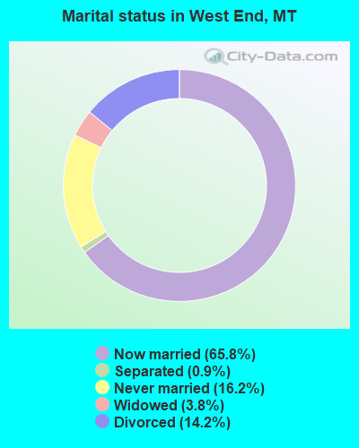
- Never married: 16.2%
- Now married: 65.8%
- Separated: 0.9%
- Widowed: 3.8%
- Divorced: 14.2%
For population 25 years and over in West End:
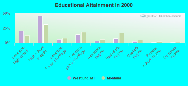
- High school or higher: 79.6%
- Bachelor's degree or higher: 10.8%
- Graduate or professional degree: 3.4%
- Unemployed: 6.0%
- Mean travel time to work (commute): 15.1 minutes
| Here: | 8.8 |
| Montana average: | 10.4 |
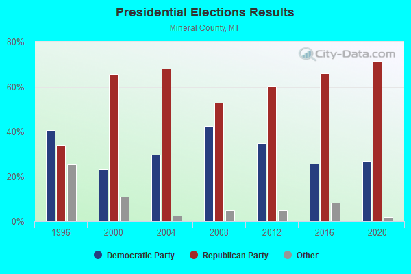
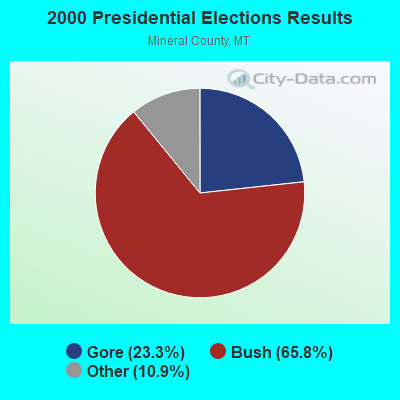
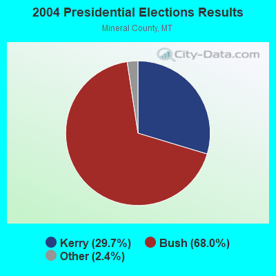
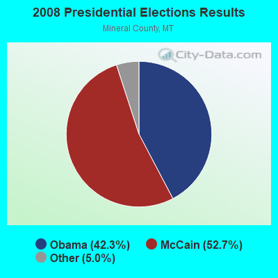
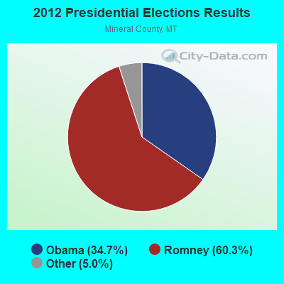
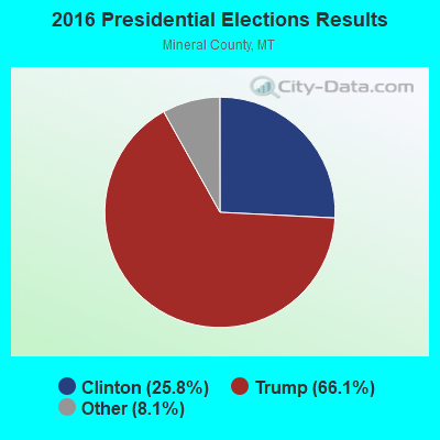
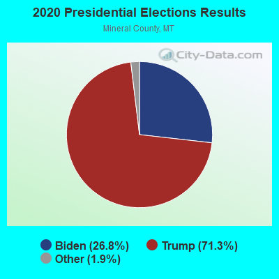
Graphs represent county-level data. Detailed 2008 Election Results
Religion statistics for West End, MT (based on Mineral County data)
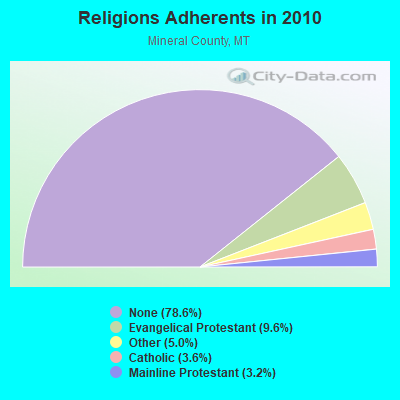
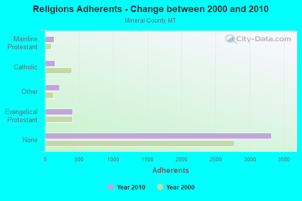
| Religion | Adherents | Congregations |
|---|---|---|
| Evangelical Protestant | 406 | 9 |
| Other | 212 | 2 |
| Catholic | 150 | 2 |
| Mainline Protestant | 135 | 2 |
| None | 3,320 | - |
Food Environment Statistics:
| This county: | 5.17 / 10,000 pop. |
| State: | 2.55 / 10,000 pop. |
| Here: | 12.91 / 10,000 pop. |
| Montana: | 4.69 / 10,000 pop. |
| Mineral County: | 10.33 / 10,000 pop. |
| State: | 10.38 / 10,000 pop. |
| Mineral County: | 9.0% |
| Montana: | 7.2% |
| Mineral County: | 26.4% |
| Montana: | 23.1% |
| This county: | 4.3% |
| Montana: | 10.7% |
Strongest AM radio stations in West End:
- KERR (750 AM; 50 kW; POLSON, MT; Owner: ANDERSON RADIO BROADCASTING, INC.)
- KOFI (1180 AM; 50 kW; KALISPELL, MT; Owner: KOFI, INC.)
- KGA (1510 AM; 50 kW; SPOKANE, WA; Owner: CITADEL BROADCASTING COMPANY)
- KXLY (920 AM; 20 kW; SPOKANE, WA; Owner: SPOKANE RADIO, INC.)
- KQQQ (1150 AM; 25 kW; PULLMAN, WA; Owner: RADIO PALOUSE, INC.)
- KVNI (1080 AM; 10 kW; COEUR D' ALENE, ID; Owner: QUEENB RADIO, INC.)
- KTBI (810 AM; daytime; 50 kW; EPHRATA, WA; Owner: TACOMA BROADCASTERS, INCORPORATED)
- KJJR (880 AM; 10 kW; WHITEFISH, MT; Owner: BEE BROADCASTING, INCORPORATED)
- KGEZ (600 AM; 5 kW; KALISPELL, MT; Owner: SKYLINE BROADCASTERS, INC.)
- KMJY (700 AM; 10 kW; NEWPORT, WA; Owner: JAMES E. AND HELEN G. STARGEL)
- KWAL (620 AM; 1 kW; WALLACE, ID; Owner: METALS BROADCASTING CO.)
- KLCY (930 AM; 5 kW; EAST MISSOULA, MT; Owner: CAPSTAR TX LIMITED PARTNERSHIP)
- KMAX (840 AM; 10 kW; COLFAX, WA; Owner: PALOUSE COUNTRY, INC.)
Strongest FM radio stations in West End:
- KPLG (91.5 FM; PLAINS, MT; Owner: YOUR NETWORK OF PRAISE, INC.)
- KLTC-FM (107.5 FM; SUPERIOR, MT; Owner: CLEAR CHANNEL BROADCASTING LICENSES, INC.)
- KTWD (97.5 FM; WALLACE, ID; Owner: CSN INTERNATIONAL)
- KQRK (92.3 FM; RONAN, MT; Owner: ANDERSON RADIO BROADCASTING, INC.)
- KALS (97.1 FM; KALISPELL, MT; Owner: KALISPELL CHRISTIAN RADIO FELLOWSHIP, INC.)
- KGGL (93.3 FM; MISSOULA, MT; Owner: FISHER RADIO REGIONAL GROUP, INC.)
- KYSS-FM (94.9 FM; MISSOULA, MT; Owner: CAPSTAR TX LIMITED PARTNERSHIP)
- KUFM (89.1 FM; MISSOULA, MT; Owner: UNIVERSITY OF MONTANA)
TV broadcast stations around West End:
- K05EE (Channel 5; BIG ARM, ETC., MT; Owner: BLACKTAIL TV TAX DISTRICT)
- K59BW (Channel 59; BONNERS FERRY, ID; Owner: STATE BOARD OF EDUCATION (IEPBS))
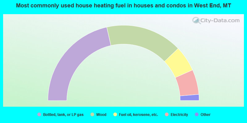
- 42.9%Bottled, tank, or LP gas
- 32.8%Wood
- 11.0%Fuel oil, kerosene, etc.
- 10.7%Electricity
- 1.2%Utility gas
- 0.9%No fuel used
- 0.6%Other fuel
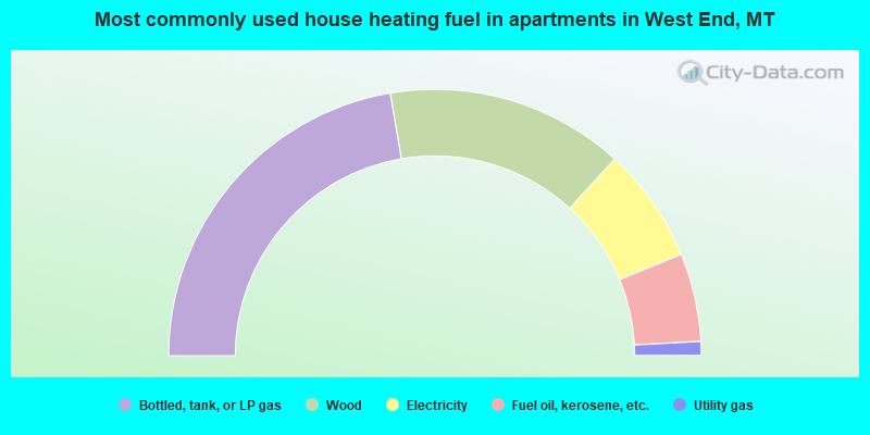
- 44.6%Bottled, tank, or LP gas
- 28.9%Wood
- 14.0%Electricity
- 10.7%Fuel oil, kerosene, etc.
- 1.7%Utility gas
West End compared to Montana state average:
- Unemployed percentage below state average.
- Black race population percentage significantly below state average.
- Hispanic race population percentage below state average.
- Foreign-born population percentage significantly below state average.
- Length of stay since moving in significantly above state average.
- Number of rooms per house significantly below state average.
- House age significantly below state average.
- Number of college students significantly below state average.
- Percentage of population with a bachelor's degree or higher below state average.