West Clark, Idaho
Submit your own pictures of this place and show them to the world
- OSM Map
- General Map
- Google Map
- MSN Map

| Males: 454 | |
| Females: 412 |
| Median resident age: | 29.7 years |
| Idaho median age: | 33.2 years |
| West Clark: | $54,792 |
| ID: | $72,785 |
Estimated per capita income in 2022: $24,394 (it was $10,823 in 2000)
West Clark CCD income, earnings, and wages data
Estimated median house or condo value in 2022: $224,989 (it was $54,300 in 2000)
| West Clark: | $224,989 |
| ID: | $432,500 |
Mean prices in 2022: all housing units: $332,145; detached houses: $417,590; mobile homes: $128,129
Detailed information about poverty and poor residents in West Clark, ID
Compare current foreclosures near West Clark, ID:
| Photo | Address | Area | Beds / Baths | Price | Details |
|---|---|---|---|---|---|

|
#1
Dry Creek Rd
Dubois, ID 83423
|
1,716 sq. feet
|
2 baths 4 beds |
$278,500
|
show details |

|
Check over 1 million property listings on Foreclosure.com!
|
browse all offers | |||

- 59062.2%White alone
- 34135.9%Hispanic
- 90.9%American Indian alone
- 50.5%Two or more races
- 20.2%Asian alone
- 10.1%Black alone
- 10.1%Native Hawaiian and Other
Pacific Islander alone

Races in West Clark detailed stats: ancestries, foreign born residents, place of birth
 Recent articles from our blog. Our writers, many of them Ph.D. graduates or candidates, create easy-to-read articles on a wide variety of topics.
Current Local Time: MST time zone
Land area: 1076.8 square miles.
Population density: 0.8 people per square mile (very low).

| West Clark CCD: | 0.5% ($288) |
| Idaho: | 1.0% ($1,007) |
Nearest city with pop. 50,000+: Idaho Falls, ID  (51.9 miles , pop. 50,730).
Nearest city with pop. 200,000+: West Adams, CO (487.5 miles , pop. 259,628).
Nearest city with pop. 1,000,000+: Phoenix, AZ (734.7 miles , pop. 1,321,045).
Nearest cities:
), )Latitude: 44.14 N, Longitude: 112.55 W
Area code commonly used in this area: 208


| Here: | 3.0% |
| Idaho: | 3.1% |

- Agriculture, forestry, fishing & hunting (36.7%)
- Food (18.0%)
- Educational services (9.7%)
- Accommodation & food services (6.3%)
- Construction (5.8%)
- Public administration (5.6%)
- Food & beverage stores (3.2%)

- Agriculture, forestry, fishing & hunting (48.0%)
- Food (13.8%)
- Construction (8.7%)
- Accommodation & food services (5.5%)
- Public administration (4.4%)
- Educational services (4.4%)
- Broadcasting & telecommunications (3.3%)

- Food (26.3%)
- Educational services (20.4%)
- Agriculture, forestry, fishing & hunting (13.9%)
- Food & beverage stores (8.0%)
- Public administration (8.0%)
- Accommodation & food services (8.0%)
- Professional, scientific, technical services (2.9%)

- Agricultural workers, including supervisors (21.4%)
- Other production occupations, including supervisors (8.5%)
- Farmers and farm managers (7.8%)
- Electrical equipment mechanics and other installation, maintenance, and repair workers, including supervisors (5.1%)
- Laborers and material movers, hand (4.9%)
- Building and grounds cleaning and maintenance occupations (4.6%)
- Secretaries and administrative assistants (3.4%)

- Agricultural workers, including supervisors (27.6%)
- Farmers and farm managers (10.9%)
- Other production occupations, including supervisors (7.3%)
- Electrical equipment mechanics and other installation, maintenance, and repair workers, including supervisors (6.9%)
- Laborers and material movers, hand (5.1%)
- Building and grounds cleaning and maintenance occupations (4.4%)
- Cooks and food preparation workers (4.0%)

- Other production occupations, including supervisors (10.9%)
- Secretaries and administrative assistants (10.2%)
- Agricultural workers, including supervisors (8.8%)
- Preschool, kindergarten, elementary, and middle school teachers (5.1%)
- Other teachers, instructors, education, training, and library occupations (5.1%)
- Building and grounds cleaning and maintenance occupations (5.1%)
- Other office and administrative support workers, including supervisors (5.1%)
Average climate in West Clark, Idaho
Based on data reported by over 4,000 weather stations


Earthquake activity:
West Clark-area historical earthquake activity is significantly above Idaho state average. It is 1688% greater than the overall U.S. average.On 8/18/1959 at 06:37:13, a magnitude 7.7 (7.7 UK, Class: Major, Intensity: VIII - XII) earthquake occurred 98.0 miles away from the city center, causing $26,000,000 total damage
On 10/28/1983 at 14:06:06, a magnitude 7.3 (6.2 MB, 7.3 MS, 7.0 MW) earthquake occurred 62.5 miles away from the city center, causing 2 deaths (2 shaking deaths) and 3 injuries, causing $15,000,000 total damage
On 10/3/1915 at 06:52:48, a magnitude 7.6 (7.6 UK) earthquake occurred 357.2 miles away from the city center
On 3/31/2020 at 23:52:30, a magnitude 6.5 (6.5 MW, Depth: 7.5 mi, Class: Strong, Intensity: VII - IX) earthquake occurred 129.2 miles away from West Clark center
On 6/30/1975 at 18:54:13, a magnitude 6.1 (5.6 MB, 5.9 MS, 6.1 UK, 6.1 ML) earthquake occurred 96.6 miles away from West Clark center
On 3/28/1975 at 02:31:05, a magnitude 6.2 (6.1 MB, 6.0 MS, 6.2 ML) earthquake occurred 147.5 miles away from the city center
Magnitude types: body-wave magnitude (MB), local magnitude (ML), surface-wave magnitude (MS), moment magnitude (MW)
Natural disasters:
The number of natural disasters in Clark County (2) is a lot smaller than the US average (15).Emergencies Declared: 1
Causes of natural disasters: Hurricane: 1, Other: 1 (Note: some incidents may be assigned to more than one category).
Colleges/universities with over 2000 students nearest to West Clark:
- Brigham Young University-Idaho (about 45 miles; Rexburg, ID; Full-time enrollment: 30,522)
- Idaho State University (about 89 miles; Pocatello, ID; FT enrollment: 10,350)
- Montana State University (about 129 miles; Bozeman, MT; FT enrollment: 12,942)
- College of Southern Idaho (about 146 miles; Twin Falls, ID; FT enrollment: 5,051)
- Utah State University (about 171 miles; Logan, UT; FT enrollment: 21,131)
- Boise State University (about 187 miles; Boise, ID; FT enrollment: 16,774)
- The University of Montana (about 201 miles; Missoula, MT; FT enrollment: 13,602)
Points of interest:
Notable locations in West Clark: Reno Ranch (A), Birch Creek Hatchery (B), Edie Ranch (C), Small (D), Cow Camp (E), Clark County Ambulance (F), Dubois City Fire Department (G). Display/hide their locations on the map
Cemeteries: Goddard Cemetery (1), John Day Cemetery (2). Display/hide their locations on the map
Lakes and reservoirs: Antelope Lakes (A), Paul Reservoir (B). Display/hide their locations on the map
Streams, rivers, and creeks: Blue Creek (A), Pass Creek (B), Patelzick Creek (C), Berry Creek (D), Poison Creek (E), Bear Pen Creek (F), Ramshorn Creek (G), Rock Creek (H), Rocky Creek (I). Display/hide their locations on the map
Park in West Clark: Indian Massacre Historical Monument (1). Display/hide its location on the map
| This place: | 2.9 people |
| Idaho: | 2.7 people |
| This place: | 72.3% |
| Whole state: | 69.6% |
| This place: | 6.8% |
| Whole state: | 6.3% |
No gay or lesbian households reported
| This place: | 19.3% |
| Whole state: | 11.8% |
| This place: | 6.3% |
| Whole state: | 4.6% |
For population 15 years and over in West Clark:

- Never married: 21.4%
- Now married: 65.5%
- Separated: 1.6%
- Widowed: 5.9%
- Divorced: 7.2%
For population 25 years and over in West Clark:
- High school or higher: 62.5%
- Bachelor's degree or higher: 12.4%
- Graduate or professional degree: 2.9%
- Unemployed: 6.6%
- Mean travel time to work (commute): 19.2 minutes


| Here: | 21.3 |
| Idaho average: | 11.1 |
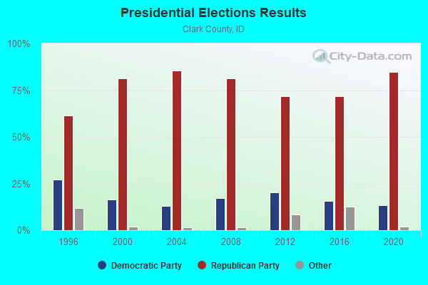
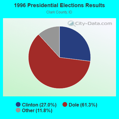
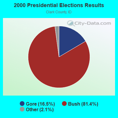
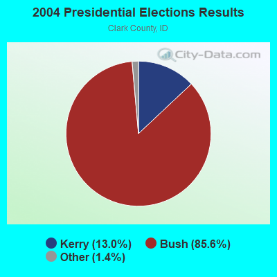
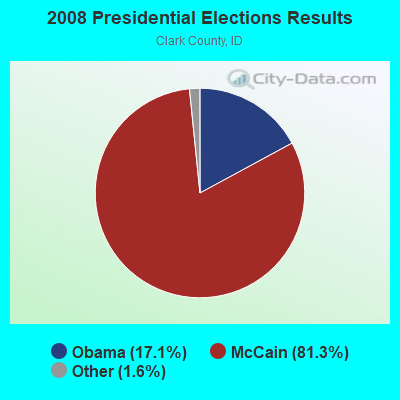
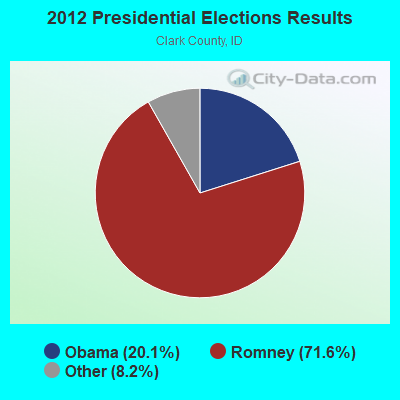


Graphs represent county-level data. Detailed 2008 Election Results
Religion statistics for West Clark, ID (based on Clark County data)
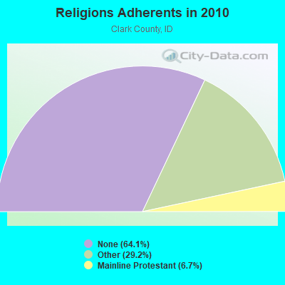
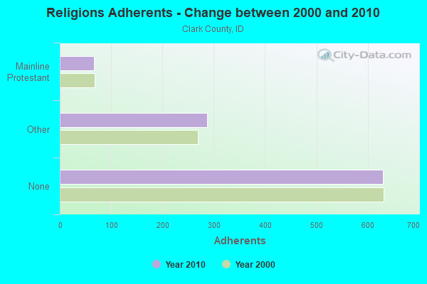
| Religion | Adherents | Congregations |
|---|---|---|
| Other | 287 | 1 |
| Mainline Protestant | 66 | 1 |
| Catholic | - | - |
| None | 629 | - |
Food Environment Statistics:
| Clark County: | 11.17 / 10,000 pop. |
| Idaho: | 3.87 / 10,000 pop. |
| Here: | 7.7% |
| Idaho: | 7.7% |
| Here: | 25.9% |
| State: | 25.7% |
| This county: | 14.9% |
| Idaho: | 11.7% |
Strongest AM radio stations in West Clark:
- KID (590 AM; 5 kW; IDAHO FALLS, ID; Owner: CITICASTERS LICENSES, L.P.)
- KZNR (690 AM; 10 kW; BLACKFOOT, ID; Owner: WESTERN COMMUNICATIONS, INC.)
- KUPI (980 AM; 5 kW; AMMON, ID; Owner: RAY GROTH OIL COMPANY, INC.)
- KBOI (670 AM; 50 kW; BOISE, ID; Owner: CITADEL BROADCASTING COMPANY)
- KZNI (1260 AM; 5 kW; IDAHO FALLS, ID)
- KBLI (1620 AM; 10 kW; BLACKFOOT, ID; Owner: WESTERN COMMUNICATIONS, INC.)
- KALL (700 AM; 50 kW; NORTH SALT LAKE CITY, UT; Owner: CITICASTERS LICENSES, L.P.)
- KERR (750 AM; 50 kW; POLSON, MT; Owner: ANDERSON RADIO BROADCASTING, INC.)
- KIQN (1010 AM; 50 kW; TOOELE, UT)
- KGVW (640 AM; 10 kW; BELGRADE, MT; Owner: GALLATIN VALLEY WITNESS, INC.)
- KWEI (1260 AM; 50 kW; WEISER, ID; Owner: TREASURE VALLEY BROADCASTING CO.)
- KSL (1160 AM; 50 kW; SALT LAKE CITY, UT; Owner: BONNEVILLE HOLDING COMPANY)
- KSEI (930 AM; 5 kW; POCATELLO, ID; Owner: PACIFIC EMPIRE COMMUNICATIONS CORP.)
Strongest FM radio stations in West Clark:
- KCVI (101.5 FM; BLACKFOOT, ID; Owner: WESTERN COMMUNICATIONS, INC.)
- KLCE (97.3 FM; BLACKFOOT, ID; Owner: WESTERN COMMUNICATIONS, INC.)
- KID-FM (96.1 FM; IDAHO FALLS, ID; Owner: CITICASTERS LICENSES, L.P.)
- KBJX (107.9 FM; SHELLEY, ID; Owner: PACIFIC EMPIRE COMMUNICATIONS CORP)
TV broadcast stations around West Clark:
- K59BV (Channel 59; LAVA HOT SPRINGS, ID; Owner: STATE BOARD OF EDUCATION (IEPBS))

- 53.1%Bottled, tank, or LP gas
- 23.5%Electricity
- 10.8%Wood
- 10.3%Fuel oil, kerosene, etc.
- 2.3%Other fuel

- 49.5%Bottled, tank, or LP gas
- 36.8%Electricity
- 7.4%Fuel oil, kerosene, etc.
- 2.1%Utility gas
- 2.1%Wood
- 2.1%No fuel used
West Clark compared to Idaho state average:
- Median house value below state average.
- Unemployed percentage below state average.
- Black race population percentage significantly below state average.
- Hispanic race population percentage above state average.
- Median age significantly below state average.
- Foreign-born population percentage significantly below state average.
- Length of stay since moving in significantly above state average.
- Number of rooms per house significantly below state average.
- House age significantly below state average.
- Number of college students significantly below state average.
- Percentage of population with a bachelor's degree or higher below state average.
West Clark on our top lists:
- #94 on the list of "Top 101 cities with the most residents born in Other Central America (population 500+)"
- #2 on the list of "Top 101 counties with highest percentage of residents voting for 3rd party candidates in the 2012 Presidential Election"
- #17 on the list of "Top 101 counties with the smallest number of people without health insurance coverage in 2000"
- #19 on the list of "Top 101 counties with the largest number of children under 18 without health insurance coverage in 2000"
- #92 on the list of "Top 101 counties with the lowest total withdrawal of fresh water for public supply"