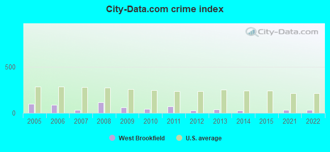
The City-Data.com crime index weighs serious crimes and violent crimes more heavily. Higher means more crime, U.S. average is 246.1. It adjusts for the number of visitors and daily workers commuting into cities.
Latest news from West Brookfield, MA collected exclusively by city-data.com from local newspapers, TV, and radio stations
Ancestries: American (29.7%), Italian (12.8%), German (8.3%), French (6.5%), French Canadian (5.9%), Irish (5.9%).
Current Local Time: EST time zone
Incorporated in 1848
Elevation: 633 feet
Land area: 1.24 square miles.
Population density: 1,142 people per square mile (low).
7 residents are foreign born
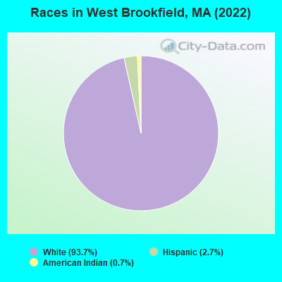
This place:
0.5%
Massachusetts:
17.6%
Median real estate property taxes paid for housing units with mortgages in 2022: $2,604 (1.0%) Median real estate property taxes paid for housing units with no mortgage in 2022: $2,698 (1.1%)
Nearest city with pop. 50,000+: Worcester, MA (17.7 miles , pop. 172,648).
Nearest city with pop. 200,000+: Boston, MA (54.4 miles , pop. 589,141).
Nearest city with pop. 1,000,000+: Bronx, NY (131.2 miles , pop. 1,332,650).
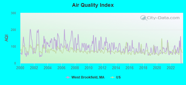
Air Quality Index (AQI) level in 2022 was 72.8. This is about average.
City:
72.8
U.S.:
72.6
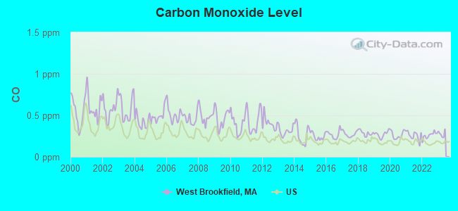
Carbon Monoxide (CO) [ppm] level in 2022 was 0.259. This is about average.Closest monitor was 17.8 miles away from the city center.
City:
0.259
U.S.:
0.251
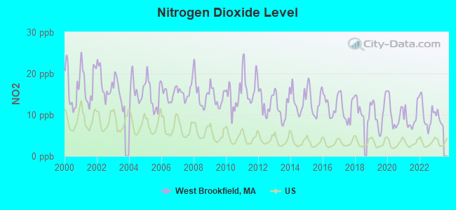
Nitrogen Dioxide (NO2) [ppb] level in 2022 was 10.1. This is significantly worse than average.Closest monitor was 16.5 miles away from the city center.
City:
10.1
U.S.:
5.1
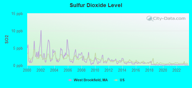
Sulfur Dioxide (SO2) [ppb] level in 2022 was 0.241. This is significantly better than average.Closest monitor was 10.6 miles away from the city center.
City:
0.241
U.S.:
1.515
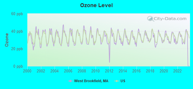
Ozone [ppb] level in 2022 was 32.4. This is about average.Closest monitor was 9.5 miles away from the city center.
City:
32.4
U.S.:
33.3
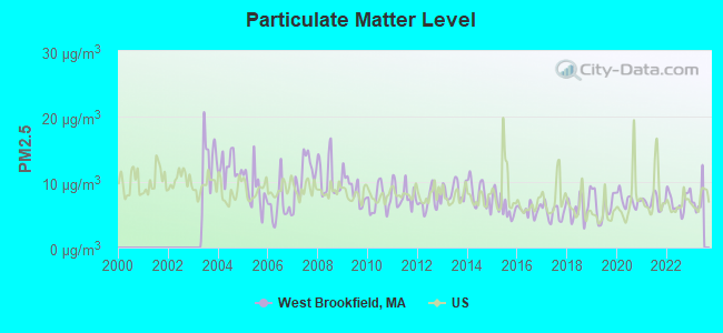
Particulate Matter (PM2.5) [µg/m3] level in 2022 was 7.08. This is about average.Closest monitor was 10.6 miles away from the city center.
City:
7.08
U.S.:
8.11
Tornado activity:
West Brookfield-area historical tornado activity is above Massachusetts state average. It is 12% smaller than the overall U.S. average.
On 6/9/1953, a category F4 (max. wind speeds 207-260 mph) tornado 16.3 miles away from the West Brookfield place center killed 90 peopleand injured 1228 peopleand causedbetween $50,000,000 and $500,000,000 in damages.
On 10/3/1970, a category F3 (max. wind speeds 158-206 mph) tornado 6.7 miles away from the place center killed one personand causedbetween $50,000 and $500,000 in damages.
Earthquake activity:
West Brookfield-area historical earthquake activity is significantly above Massachusetts state average. It is 71% smaller than the overall U.S. average.
On 10/7/1983 at 10:18:46, a magnitude 5.3 (5.1 MB, 5.3 LG, 5.1 ML, Class: Moderate, Intensity: VI - VII) earthquake occurred 162.5 miles away from the city center On 4/20/2002 at 10:50:47, a magnitude 5.3 (5.3 ML, Depth: 3.0 mi) earthquake occurred 175.7 miles away from West Brookfield center On 4/20/2002 at 10:50:47, a magnitude 5.2 (5.2 MB, 4.2 MS, 5.2 MW, 5.0 MW) earthquake occurred 174.6 miles away from West Brookfield center On 1/19/1982 at 00:14:42, a magnitude 4.7 (4.5 MB, 4.7 MD, 4.5 LG, Class: Light, Intensity: IV - V) earthquake occurred 91.7 miles away from the city center On 10/16/2012 at 23:12:25, a magnitude 4.7 (4.7 ML, Depth: 10.0 mi) earthquake occurred 120.7 miles away from West Brookfield center On 10/2/1994 at 11:27:22, a magnitude 3.7 (3.5 LG, 3.7 LG, Depth: 6.2 mi, Class: Light, Intensity: II - III) earthquake occurred 10.2 miles away from the city center Magnitude types: regional Lg-wave magnitude (LG), body-wave magnitude (MB), duration magnitude (MD), local magnitude (ML), surface-wave magnitude (MS), moment magnitude (MW)
Natural disasters:
The number of natural disasters in Worcester County (27) is a lot greater than the US average (15). Major Disasters (Presidential) Declared: 15 Emergencies Declared: 12
Causes of natural disasters: Floods: 9, Storms: 8, Hurricanes: 6, Snowstorms: 5, Winter Storms: 4, Blizzards: 2, Snows: 2, Fire: 1, Heavy Rain: 1, Snowfall: 1, Tornado: 1, Wind: 1 (Note: some incidents may be assigned to more than one category).
Hospitals and medical centers in West Brookfield:
GUARDIAN HOSPICE OF MASSACHUSETTS, INC (47 EAST MAIN STREET)
QUABOAG REHABILITATION AND SKILLED CARE CENTER (47 EAST MAIN STREET)
Other hospitals and medical centers near West Brookfield:
BAYSTATE MARY LANE HOSPITAL Acute Care Hospitals (about 6 miles away; WARE, MA)
FAMILY HOME CARE, INC (Home Health Center, about 8 miles away; SPENCER, MA)
PALMER HEALTHCARE CENTER (Nursing Home, about 11 miles away; PALMER, MA)
OVERLOOK VNA AND HOSPICE SERVICES (Hospital, about 11 miles away; CHARLTON, MA)
FMC DIALYSIS SERVICES OF PALMER (Dialysis Facility, about 12 miles away; PALMER, MA)
MONSON DEVELOPMENTAL CENTER (Hospital, about 12 miles away; PALMER, MA)
WING MEMORIAL HOSPITAL AND MEDICAL CENTER Acute Care Hospitals (about 12 miles away; PALMER, MA)
MERRIAM-GILBERT PUBLIC LIBRARY (Operating income: $196,799; Location: 3 WEST MAIN ST.; 12,542 books; 930 e-books; 1,930 audio materials; 1,690 video materials; 34 state licensed databases; 32 print serial subscriptions)
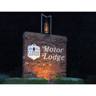
Hotel: Copper Lantern Motor Lodge (184 West Main Street).
Birthplace of: Daniel Henry Chamberlain - Planter, Lucy Stone - (1818-1893), women's rights activist.
Worcester County has a predicted average indoor radon screening level greater than 4 pCi/L (pico curies per liter) - Highest Potential
Drinking water stations with addresses in West Brookfield and their reported violations in the past:
WEST BROOKFIELD WATER DEPARTMENT (Population served: 2,477, Groundwater):
Past monitoring violations:
Monitoring and Reporting (DBP) - Between OCT-2012 and DEC-2012, Contaminant: Chlorine. Follow-up actions: St AO (w/o penalty) issued (FEB-27-2013), St Compliance achieved (MAR-06-2013)
MCL, Monthly (TCR) - In SEP-2013, Contaminant: Coliform. Follow-up actions: St AO (w/o penalty) issued (NOV-02-2012)
MCL, Monthly (TCR) - In JAN-2013, Contaminant: Coliform. Follow-up actions: St AO (w/o penalty) issued (NOV-02-2012)
MCL, Monthly (TCR) - In OCT-2012, Contaminant: Coliform. Follow-up actions: St AO (w/o penalty) issued (NOV-02-2012)
MCL, Monthly (TCR) - In JUN-2010, Contaminant: Coliform. Follow-up actions: St AO (w/o penalty) issued (AUG-17-2010), St Compliance achieved (AUG-17-2010)
MCL, Monthly (TCR) - In JAN-2010, Contaminant: Coliform. Follow-up actions: St AO (w/o penalty) issued (AUG-11-2009), St AO (w/penalty) issued (NOV-11-2009), St AO (w/o penalty) issued (MAR-08-2010)
MCL, Acute (TCR) - In DEC-2009, Contaminant: Coliform. Follow-up actions: St AO (w/o penalty) issued (AUG-11-2009), St AO (w/penalty) issued (NOV-11-2009), St AO (w/o penalty) issued (MAR-08-2010)
6 other older health violations
Past monitoring violations:
Monitoring, Repeat Major (TCR) - In JAN-2010, Contaminant: Coliform (TCR). Follow-up actions: St AO (w/o penalty) issued (AUG-11-2009), St AO (w/penalty) issued (NOV-11-2009), St AO (w/o penalty) issued (MAR-08-2010)
Monitoring, Repeat Major (TCR) - In DEC-2009, Contaminant: Coliform (TCR). Follow-up actions: St AO (w/o penalty) issued (AUG-11-2009), St AO (w/penalty) issued (NOV-11-2009), St AO (w/o penalty) issued (MAR-08-2010)
Follow-up Or Routine LCR Tap M/R - In JUL-01-2009, Contaminant: Lead and Copper Rule. Follow-up actions: St AO (w/penalty) issued (NOV-11-2009), St AO (w/o penalty) issued (DEC-14-2009), St Compliance achieved (AUG-12-2010)
Monitoring, Repeat Major (TCR) - In APR-2009, Contaminant: Coliform (TCR). Follow-up actions: St AO (w/o penalty) issued (2 times from MAY-22-2009 to JUN-30-2009), St Compliance achieved (2 times from JUL-30-2009 to JUL-30-2009)
One routine major monitoring violation
13 minor monitoring violations
100 regular monitoring violations
Average household size:
This place:
2.2 people
Massachusetts:
2.5 people
Percentage of family households:
This place:
56.6%
Whole state:
63.0%
Percentage of households with unmarried partners:
This place:
5.3%
Whole state:
7.0%
Likely homosexual households (counted as self-reported same-sex unmarried-partner households)
Lesbian couples: 0.5% of all households
Gay men: 0.8% of all households
130 people in nursing facilities/skilled-nursing facilities in 2010
4 people in group homes intended for adults in 2010
327 people in nursing homes in 2000
9 people in other nonhousehold living situations in 2000
Banks with branches in West Brookfield (2011 data):
Country Bank for Savings: West Brookfield Branch at 8 West Main Street, branch established on 1977/03/19. Info updated 2006/09/29: Bank assets: $1,431.1 mil, Deposits: $953.8 mil, headquarters in Ware, MA, positive income, Mortgage Lending Specialization, 15 total offices
North Brookfield Savings Bank: West Brookfield Branch at 128 West Main Street, branch established on 1989/06/10. Info updated 2011/08/31: Bank assets: $198.6 mil, Deposits: $169.4 mil, headquarters in North Brookfield, MA, positive income, Mortgage Lending Specialization, 4 total offices
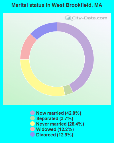
For population 15 years and over in West Brookfield:
Never married: 28.4%
Now married: 42.8%
Separated: 3.7%
Widowed: 12.2%
Divorced: 12.9%
For population 25 years and over in West Brookfield:
Religion statistics for West Brookfield, MA (based on Worcester County data)
Religion
Adherents
Congregations
Catholic
306,925
118
Mainline Protestant
43,326
171
Evangelical Protestant
37,511
203
Other
18,931
69
Orthodox
7,935
15
Black Protestant
497
6
None
383,427
-
Source: Clifford Grammich, Kirk Hadaway, Richard Houseal, Dale E.Jones, Alexei Krindatch, Richie Stanley and Richard H.Taylor. 2012. 2010 U.S.Religion Census: Religious Congregations & Membership Study. Association of Statisticians of American Religious Bodies. Jones, Dale E., et al. 2002. Congregations and Membership in the United States 2000. Nashville, TN: Glenmary Research Center. Graphs represent county-level data
Ragged Hill, Ragged Hill - Ma State Tower #27 (Lat: 42.287778 Lon: -72.184167), Type: Building, Structure height: 91.4 m, Overall height: 92.7 m, Call Sign: WQCH369, Assigned Frequencies: 462.962 MHz, 462.975 MHz, 462.987 MHz, 463.000 MHz, 463.012 MHz, 463.025 MHz, 463.037 MHz, 463.050 MHz, 463.062 MHz, 463.075 MHz... (+9 more), Grant Date: 03/19/2015, Expiration Date: 03/03/2025, Certifier: Edward Mcnamara, Registrant: Central Massachusetts Emergency Medical Systems Corporation, 361 Holden Street, Holden, MA 01520, Phone: (508) 854-0111, Fax: (508) 853-3672, Email:
89 N Main St (Lat: 42.240194 Lon: -72.133306), Type: Bant, Structure height: 5 m, Overall height: 8 m, Call Sign: WQOG408, Assigned Frequencies: 462.750 MHz, Grant Date: 09/16/2011, Expiration Date: 09/16/2021, Cancellation Date: 11/20/2021, Certifier: Joseph Scanlon, Registrant: Visiplex, Inc., 100 N Fairway Dr, Suite 120, Vernon Hills, IL 60061, Phone: (847) 918-0250, Fax: (847) 918-0259, Email:
Ragged Hill Woods Rd (Lat: 42.288333 Lon: -72.183333), Type: Ltower, Structure height: 55.8 m, Overall height: 61.5 m, Call Sign: WQPZ800, Assigned Frequencies: 4977.50 MHz, Grant Date: 09/26/2022, Expiration Date: 10/01/2032, Certifier: Charles B Sutherland, Registrant: Massachusetts, Commonwealth Of Department Of State Police, 470 Worcester Rd, Framingham, MA 01702, Phone: (508) 820-2222, Email:
Aircraft: BEECHCRAFT CORP G58 (Category: Land, Engines: 2, Seats: 6, Weight: Up to 12,499 Pounds), Engine: CONT MOTOR IO-550-C (300 HP) (Reciprocating) N-Number: 172DH, N172DH, N-172DH, Serial Number: TH-2403, Year manufactured: 2014, Airworthiness Date: 02/06/2014, Certificate Issue Date: 10/10/2014 Registrant (LLC): Santa Lucia 930 LLC, 81 Ragged Hill Rd, West Brookfield, MA 01585
Aircraft: PIPER J3C-65 (Category: Land, Seats: 2, Weight: Up to 12,499 Pounds, Speed: 67 mph), Engine: CONT MOTOR C85 SERIES (85 HP) (Reciprocating) N-Number: 26182, N26182, N-26182, Serial Number: 4107, Year manufactured: 1948, Airworthiness Date: 06/30/1958, Certificate Issue Date: 02/20/1981 Registrant (Individual): Donald E Richards, Lake View Ave Ext, West Brookfield, MA 01585
Aircraft: CESSNA 172 (Category: Land, Seats: 4, Weight: Up to 12,499 Pounds, Speed: 105 mph), Engine: CONT MOTOR 0-300 SER (145 HP) (Reciprocating) N-Number: 6109E, N6109E, N-6109E, Serial Number: 46209, Year manufactured: 1958, Airworthiness Date: 10/31/1958, Certificate Issue Date: 05/17/2018 Registrant (Individual): Christoper J Lucia, 81 Ragged Hill Rd, West Brookfield, MA 01585
Aircraft: MAULE M-7-260 (Category: Land, Seats: 5, Weight: Up to 12,499 Pounds), Engine: LYCOMING IO-540 SER (300 HP) (Reciprocating) N-Number: 778JB, N778JB, N-778JB, Serial Number: 26017C, Year manufactured: 2005, Airworthiness Date: 09/12/2005, Certificate Issue Date: 04/03/2019 Registrant (Individual): Christopher J Lucia, 81 Ragged Hill Rd, West Brookfield, MA 01585 Deregistered:Cancel Date: 09/22/2005
Aircraft: FLIGHT DESIGN GMBH CTLS (Category: Land, Seats: 2, Weight: Up to 12,499 Pounds), Engine: ROTAX 912ULS SERIES (100 HP) (4 Cycle) N-Number: 909KM, N909KM, N-909KM, Serial Number: F-10-10-10, Year manufactured: 2010, Airworthiness Date: 03/17/2011, Certificate Issue Date: 03/16/2019 Registrant (Co-Owned): Theodore M Trustee Pas, Po Box 552, West Brookfield, MA 01585, Other Owners: Judith M Trustee Pas
Aircraft: CHAMPION 7GCAA (Category: Land, Seats: 2, Weight: Up to 12,499 Pounds, Speed: 90 mph), Engine: LYCOMING 0-320 SERIES (180 HP) (Reciprocating) N-Number: 1879G, N1879G, N-1879G, Serial Number: 65, Year manufactured: 1968, Airworthiness Date: 06/18/1968, Certificate Issue Date: 06/24/2008 Registrant (Individual): Colleen M Mucha, 44 Kennedy Rd, West Brookfield, MA 01585 Deregistered:Cancel Date: 01/03/2018
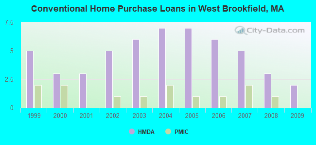
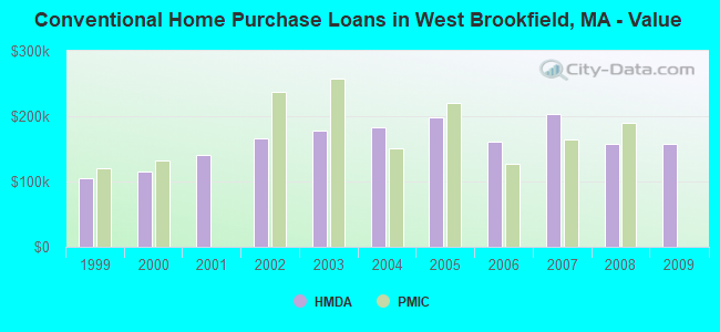
Home Mortgage Disclosure Act Aggregated Statistics For Year 2009 (Based on 1 partial tract)
A) FHA, FSA/RHS & VA Home Purchase Loans
B) Conventional Home Purchase Loans
C) Refinancings
D) Home Improvement Loans
Number
Average Value
Number
Average Value
Number
Average Value
Number
Average Value
LOANS ORIGINATED
1
$160,400
2
$157,960
7
$184,277
1
$139,350
APPLICATIONS APPROVED, NOT ACCEPTED
0
$0
0
$0
0
$0
0
$0
APPLICATIONS DENIED
0
$0
0
$0
3
$204,467
0
$0
APPLICATIONS WITHDRAWN
0
$0
1
$82,090
1
$266,830
0
$0
FILES CLOSED FOR INCOMPLETENESS
0
$0
0
$0
1
$82,180
0
$0
Aggregated Statistics For Year 2008 (Based on 1 partial tract)
B) Conventional Home Purchase Loans
C) Refinancings
D) Home Improvement Loans
F) Non-occupant Loans on < 5 Family Dwellings (A B C & D)
Number
Average Value
Number
Average Value
Number
Average Value
Number
Average Value
LOANS ORIGINATED
3
$156,893
5
$183,742
1
$164,610
1
$125,460
APPLICATIONS APPROVED, NOT ACCEPTED
1
$70,050
1
$92,620
0
$0
0
$0
APPLICATIONS DENIED
0
$0
2
$246,370
1
$73,840
0
$0
APPLICATIONS WITHDRAWN
0
$0
1
$166,800
0
$0
0
$0
FILES CLOSED FOR INCOMPLETENESS
0
$0
0
$0
0
$0
0
$0
Aggregated Statistics For Year 2007 (Based on 1 partial tract)
B) Conventional Home Purchase Loans
C) Refinancings
D) Home Improvement Loans
F) Non-occupant Loans on < 5 Family Dwellings (A B C & D)
Number
Average Value
Number
Average Value
Number
Average Value
Number
Average Value
LOANS ORIGINATED
5
$203,848
7
$154,700
1
$110,130
1
$151,900
APPLICATIONS APPROVED, NOT ACCEPTED
1
$107,940
1
$309,600
0
$0
0
$0
APPLICATIONS DENIED
2
$138,045
6
$202,150
1
$53,550
0
$0
APPLICATIONS WITHDRAWN
0
$0
2
$204,145
0
$0
0
$0
FILES CLOSED FOR INCOMPLETENESS
0
$0
1
$192,310
0
$0
0
$0
Aggregated Statistics For Year 2006 (Based on 1 partial tract)
B) Conventional Home Purchase Loans
C) Refinancings
D) Home Improvement Loans
F) Non-occupant Loans on < 5 Family Dwellings (A B C & D)
Number
Average Value
Number
Average Value
Number
Average Value
Number
Average Value
LOANS ORIGINATED
6
$160,935
9
$153,374
3
$70,280
1
$139,520
APPLICATIONS APPROVED, NOT ACCEPTED
1
$81,760
1
$215,640
0
$0
0
$0
APPLICATIONS DENIED
1
$272,980
5
$208,328
1
$91,610
0
$0
APPLICATIONS WITHDRAWN
1
$113,920
4
$178,568
0
$0
0
$0
FILES CLOSED FOR INCOMPLETENESS
0
$0
1
$140,530
0
$0
0
$0
Aggregated Statistics For Year 2005 (Based on 1 partial tract)
B) Conventional Home Purchase Loans
C) Refinancings
D) Home Improvement Loans
F) Non-occupant Loans on < 5 Family Dwellings (A B C & D)
Number
Average Value
Number
Average Value
Number
Average Value
Number
Average Value
LOANS ORIGINATED
7
$198,123
12
$176,658
3
$91,580
1
$115,440
APPLICATIONS APPROVED, NOT ACCEPTED
1
$134,720
1
$260,180
0
$0
0
$0
APPLICATIONS DENIED
1
$158,800
6
$176,595
1
$49,090
0
$0
APPLICATIONS WITHDRAWN
1
$103,230
6
$184,833
1
$171,600
0
$0
FILES CLOSED FOR INCOMPLETENESS
1
$67,870
4
$180,902
0
$0
0
$0
Aggregated Statistics For Year 2004 (Based on 1 partial tract)
B) Conventional Home Purchase Loans
C) Refinancings
D) Home Improvement Loans
F) Non-occupant Loans on < 5 Family Dwellings (A B C & D)
Number
Average Value
Number
Average Value
Number
Average Value
Number
Average Value
LOANS ORIGINATED
7
$182,859
11
$152,042
3
$100,197
1
$209,410
APPLICATIONS APPROVED, NOT ACCEPTED
1
$82,850
2
$143,815
0
$0
0
$0
APPLICATIONS DENIED
1
$90,090
4
$164,822
1
$93,880
0
$0
APPLICATIONS WITHDRAWN
1
$136,660
4
$168,272
0
$0
0
$0
FILES CLOSED FOR INCOMPLETENESS
0
$0
3
$131,017
0
$0
0
$0
Aggregated Statistics For Year 2003 (Based on 1 partial tract)
B) Conventional Home Purchase Loans
C) Refinancings
D) Home Improvement Loans
F) Non-occupant Loans on < 5 Family Dwellings (A B C & D)
Number
Average Value
Number
Average Value
Number
Average Value
Number
Average Value
LOANS ORIGINATED
6
$178,223
23
$137,499
1
$37,720
1
$163,180
APPLICATIONS APPROVED, NOT ACCEPTED
1
$198,040
2
$148,910
0
$0
0
$0
APPLICATIONS DENIED
1
$171,350
8
$140,140
1
$34,940
0
$0
APPLICATIONS WITHDRAWN
1
$109,630
4
$135,330
0
$0
0
$0
FILES CLOSED FOR INCOMPLETENESS
0
$0
0
$0
0
$0
0
$0
Aggregated Statistics For Year 2002 (Based on 1 partial tract)
B) Conventional Home Purchase Loans
C) Refinancings
D) Home Improvement Loans
F) Non-occupant Loans on < 5 Family Dwellings (A B C & D)
Number
Average Value
Number
Average Value
Number
Average Value
Number
Average Value
LOANS ORIGINATED
5
$165,336
13
$133,185
1
$25,510
1
$34,520
APPLICATIONS APPROVED, NOT ACCEPTED
0
$0
1
$157,790
0
$0
0
$0
APPLICATIONS DENIED
0
$0
3
$99,580
1
$25,430
0
$0
APPLICATIONS WITHDRAWN
1
$124,190
3
$114,990
0
$0
0
$0
FILES CLOSED FOR INCOMPLETENESS
0
$0
1
$104,240
0
$0
0
$0
Aggregated Statistics For Year 2001 (Based on 1 partial tract)
B) Conventional Home Purchase Loans
C) Refinancings
D) Home Improvement Loans
Number
Average Value
Number
Average Value
Number
Average Value
LOANS ORIGINATED
3
$141,400
10
$114,419
1
$21,980
APPLICATIONS APPROVED, NOT ACCEPTED
0
$0
1
$155,100
0
$0
APPLICATIONS DENIED
0
$0
2
$89,085
0
$0
APPLICATIONS WITHDRAWN
1
$55,150
3
$77,857
0
$0
FILES CLOSED FOR INCOMPLETENESS
0
$0
0
$0
0
$0
Aggregated Statistics For Year 2000 (Based on 1 partial tract)
A) FHA, FSA/RHS & VA Home Purchase Loans
B) Conventional Home Purchase Loans
C) Refinancings
D) Home Improvement Loans
Number
Average Value
Number
Average Value
Number
Average Value
Number
Average Value
LOANS ORIGINATED
1
$104,160
3
$114,567
3
$70,727
2
$13,975
APPLICATIONS APPROVED, NOT ACCEPTED
0
$0
1
$90,090
1
$63,570
0
$0
APPLICATIONS DENIED
0
$0
1
$58,600
2
$60,920
1
$18,190
APPLICATIONS WITHDRAWN
0
$0
1
$58,350
2
$45,595
0
$0
FILES CLOSED FOR INCOMPLETENESS
0
$0
0
$0
1
$88,410
0
$0
Aggregated Statistics For Year 1999 (Based on 1 partial tract)
Detailed PMIC statistics for the following Tracts:7241.00
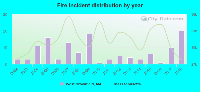
2002 - 2018 National Fire Incident Reporting System (NFIRS) incidents
Based on the data from the years 2002 - 2018 the average number of fires per year is 7. The highest number of reported fire incidents - 20 took place in 2018, and the least - 1 in 2010. The data has a rising trend.
When looking into fire subcategories, the most incidents belonged to: Structure Fires (69.3%), and Outside Fires (17.3%).
Fire incident types reported to NFIRS in West Brookfield, MA


 Recent articles from our blog. Our writers, many of them Ph.D. graduates or candidates, create easy-to-read articles on a wide variety of topics.


 (17.7 miles


 Based on the data from the years 2002 - 2018 the average number of fires per year is 7. The highest number of reported fire incidents - 20 took place in 2018, and the least - 1 in 2010. The data has a rising trend.
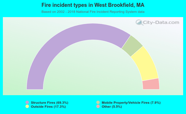 When looking into fire subcategories, the most incidents belonged to: Structure Fires (69.3%), and Outside Fires (17.3%).