Waresboro, Georgia
Submit your own pictures of this place and show them to the world
- OSM Map
- General Map
- Google Map
- MSN Map

| Males: 3,893 | |
| Females: 2,831 |
| Median resident age: | 35.7 years |
| Georgia median age: | 33.4 years |
Zip code: 31552
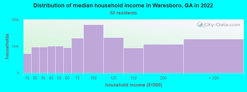
| Waresboro: | $51,476 |
| GA: | $72,837 |
Estimated per capita income in 2022: $20,728 (it was $12,605 in 2000)
Waresboro CCD income, earnings, and wages data
Estimated median house or condo value in 2022: $117,464 (it was $53,900 in 2000)
| Waresboro: | $117,464 |
| GA: | $297,400 |
Detailed information about poverty and poor residents in Waresboro, GA


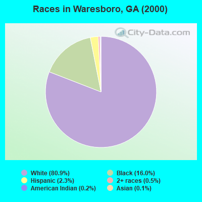
- 5,36680.9%White alone
- 1,06116.0%Black alone
- 1502.3%Hispanic
- 320.5%Two or more races
- 100.2%American Indian alone
- 70.1%Asian alone
- 50.08%Native Hawaiian and Other
Pacific Islander alone - 10.02%Other race alone
Races in Waresboro detailed stats: ancestries, foreign born residents, place of birth
 Recent articles from our blog. Our writers, many of them Ph.D. graduates or candidates, create easy-to-read articles on a wide variety of topics.

Current Local Time: EST time zone
Elevation: 145 feet
Land area: 127.2 square miles.
Population density: 53 people per square mile (very low).

| Waresboro CCD: | 0.9% ($461) |
| Georgia: | 0.9% ($919) |
Nearest city with pop. 50,000+: Jacksonville, FL  (82.7 miles , pop. 735,617).
Nearest city with pop. 1,000,000+: Philadelphia, PA (732.1 miles , pop. 1,517,550).
Nearest cities:
), ), ), ), ), Latitude: 31.26 N, Longitude: 82.52 W
Area code commonly used in this area: 912

| Here: | 2.8% |
| Georgia: | 2.9% |
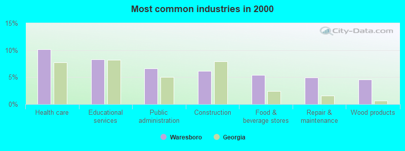
- Health care (10.2%)
- Educational services (8.3%)
- Public administration (6.6%)
- Construction (6.2%)
- Food & beverage stores (5.4%)
- Repair & maintenance (4.9%)
- Wood products (4.6%)

- Construction (11.3%)
- Public administration (6.9%)
- Rail transportation (6.4%)
- Wood products (6.3%)
- Repair & maintenance (5.3%)
- Food & beverage stores (4.6%)
- Health care (4.2%)
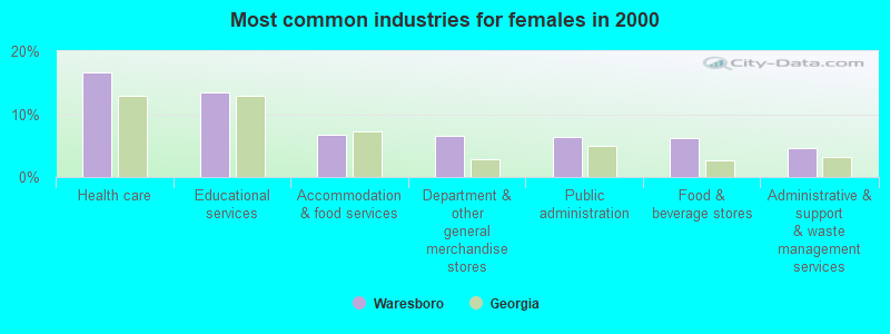
- Health care (16.7%)
- Educational services (13.5%)
- Accommodation & food services (6.8%)
- Department & other general merchandise stores (6.5%)
- Public administration (6.3%)
- Food & beverage stores (6.2%)
- Administrative & support & waste management services (4.6%)
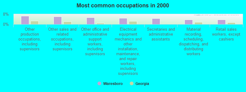
- Other production occupations, including supervisors (6.6%)
- Other sales and related occupations, including supervisors (6.1%)
- Other office and administrative support workers, including supervisors (5.4%)
- Electrical equipment mechanics and other installation, maintenance, and repair workers, including supervisors (4.8%)
- Secretaries and administrative assistants (4.5%)
- Material recording, scheduling, dispatching, and distributing workers (3.7%)
- Retail sales workers, except cashiers (3.7%)
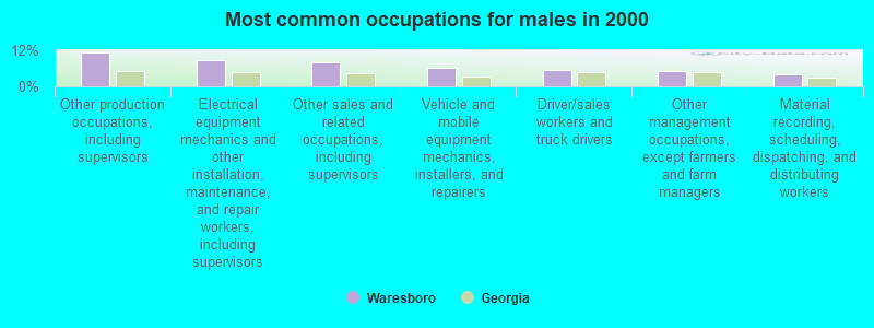
- Other production occupations, including supervisors (11.1%)
- Electrical equipment mechanics and other installation, maintenance, and repair workers, including supervisors (8.8%)
- Other sales and related occupations, including supervisors (8.1%)
- Vehicle and mobile equipment mechanics, installers, and repairers (6.1%)
- Driver/sales workers and truck drivers (5.5%)
- Other management occupations, except farmers and farm managers (5.1%)
- Material recording, scheduling, dispatching, and distributing workers (4.1%)
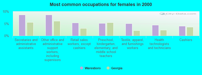
- Secretaries and administrative assistants (8.7%)
- Other office and administrative support workers, including supervisors (8.6%)
- Retail sales workers, except cashiers (5.4%)
- Preschool, kindergarten, elementary, and middle school teachers (5.2%)
- Textile, apparel, and furnishings workers (5.0%)
- Health technologists and technicians (4.4%)
- Cashiers (4.1%)
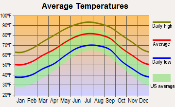
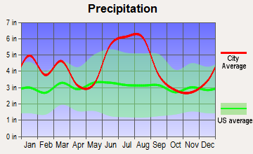
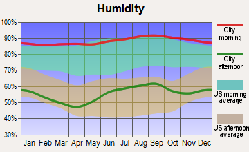
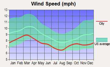
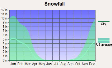
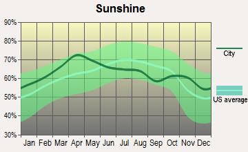
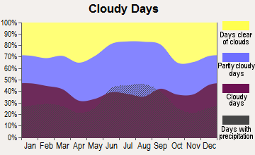
Average climate in Waresboro, Georgia
Based on data reported by over 4,000 weather stations
(lower is better)
Lead (Pb) [µg/m3] level in 2018 was 0.00200. This is significantly better than average. Closest monitor was 22.2 miles away from the city center.
| City: | 0.00200 |
| U.S.: | 0.00931 |
Tornado activity:
Waresboro-area historical tornado activity is below Georgia state average. It is 13% smaller than the overall U.S. average.
On 11/18/1968, a category F3 (max. wind speeds 158-206 mph) tornado 14.3 miles away from the Waresboro place center caused between $5000 and $50,000 in damages.
On 2/25/1970, a category F2 (max. wind speeds 113-157 mph) tornado 4.8 miles away from the place center injured 2 people and caused between $50,000 and $500,000 in damages.
Earthquake activity:
Waresboro-area historical earthquake activity is significantly above Georgia state average. It is 43% smaller than the overall U.S. average.On 8/2/1974 at 08:52:09, a magnitude 4.9 (4.3 MB, 4.9 LG, Class: Light, Intensity: IV - V) earthquake occurred 180.5 miles away from the city center
On 11/22/1974 at 05:25:55, a magnitude 4.7 (4.7 MB) earthquake occurred 179.3 miles away from the city center
On 8/21/1992 at 16:31:55, a magnitude 4.4 (4.1 MB, 4.1 LG, 4.4 LG, Depth: 6.2 mi) earthquake occurred 187.2 miles away from the city center
On 10/24/1997 at 08:35:17, a magnitude 4.9 (4.8 MB, 4.2 MS, 4.9 LG, Depth: 6.2 mi) earthquake occurred 281.5 miles away from the city center
On 4/29/2003 at 08:59:39, a magnitude 4.9 (4.4 MB, 4.6 MW, 4.9 LG) earthquake occurred 287.5 miles away from the city center
On 7/13/2003 at 20:15:16, a magnitude 3.6 (3.6 MB, Depth: 3.1 mi, Class: Light, Intensity: II - III) earthquake occurred 77.4 miles away from Waresboro center
Magnitude types: regional Lg-wave magnitude (LG), body-wave magnitude (MB), surface-wave magnitude (MS), moment magnitude (MW)
Natural disasters:
The number of natural disasters in Ware County (13) is near the US average (15).Major Disasters (Presidential) Declared: 4
Emergencies Declared: 4
Causes of natural disasters: Storms: 4, Fires: 3, Floods: 3, Hurricanes: 3, Tornadoes: 3, Winds: 2, Drought: 1, Snowfall: 1, Winter Storm: 1, Other: 1 (Note: some incidents may be assigned to more than one category).
Hospitals and medical centers near Waresboro:
- WAYCROSS HEALTH AND REHABILITATION (Nursing Home, about 10 miles away; WAYCROSS, GA)
- BAPTIST VILLAGE, INC. (Nursing Home, about 10 miles away; WAYCROSS, GA)
- SATILLA CARE CENTER (Nursing Home, about 10 miles away; WAYCROSS, GA)
- SATILLA RIVER DIALYSIS (Dialysis Facility, about 10 miles away; WAYCROSS, GA)
- HOSPICE SATILLA OF MEM HOSP (Hospital, about 11 miles away; WAYCROSS, GA)
- WARE VISITING NURSES SERVICE, INC (Home Health Center, about 11 miles away; WAYCROSS, GA)
- AMEDISYS HOME HEALTH (Home Health Center, about 11 miles away; WAYCROSS, GA)
Colleges/universities with over 2000 students nearest to Waresboro:
- South Georgia State College (about 26 miles; Douglas, GA; Full-time enrollment: 2,507)
- Valdosta State University (about 54 miles; Valdosta, GA; FT enrollment: 11,155)
- Wiregrass Georgia Technical College (about 56 miles; Valdosta, GA; FT enrollment: 3,246)
- College of Coastal Georgia (about 62 miles; Brunswick, GA; FT enrollment: 2,447)
- Abraham Baldwin Agricultural College (about 62 miles; Tifton, GA; FT enrollment: 2,564)
- Florida Gateway College (about 76 miles; Lake City, FL; FT enrollment: 2,179)
- Florida State College at Jacksonville (about 82 miles; Jacksonville, FL; FT enrollment: 21,810)
Points of interest:
Notable locations in Waresboro: Satilla Regional Rehabilitation Institute (A), J Olan Jones Health Care Center (B), Baptist Village Nursing Home (C), Ware County Fire / Rescue Station 7 Millwood (D), Ware County Fire / Rescue Station 1 Industrial Park (E), Ware County Fire / Rescue Station 8 Peeble Hill (F), Ware County Fire / Rescue Station 9 Waresboro (G). Display/hide their locations on the map
Churches in Waresboro include: Ezekiel Church (A), Friendship Church (B), Hargrave Chapel (C), Jamestown United Methodist Church (D), Bible Baptist Church (E), Waresboro First United Methodist Church (F), Indian Mound Church (G), Pebble Hill Church (H), Millwood Church (I). Display/hide their locations on the map
Cemeteries: Bennett Cemetery (1), Crestwood Memorial Gardens (2), Walden Cemetery (3), Waresboro Cemetery (4). Display/hide their locations on the map
Lakes, reservoirs, and swamps: Gator Head Pond (A), Shriners Club Lake (B), Huckleberry Bay (C), Musket Bay (D), Long Pond (E), Bennett Bay (F). Display/hide their locations on the map
Streams, rivers, and creeks: Hog Creek (A), Seventeen Mile River (B), Red Bluff Creek (C), Fullwood Creek (D), Cox Creek (E), Coon Branch (F), Perch Creek (G), Mill Branch (H), Kettle Creek (I). Display/hide their locations on the map
| This place: | 2.6 people |
| Georgia: | 2.6 people |
| This place: | 73.1% |
| Whole state: | 68.5% |
| This place: | 5.2% |
| Whole state: | 5.9% |
Likely homosexual households (counted as self-reported same-sex unmarried-partner households)
- Lesbian couples: 0.3% of all households
- Gay men: 0.4% of all households
| This place: | 10.6% |
| Whole state: | 13.0% |
| This place: | 4.4% |
| Whole state: | 6.1% |
People in group quarters in Waresboro in 2010:
- 1,529 people in state prisons
- 397 people in local jails and other municipal confinement facilities
- 243 people in nursing facilities/skilled-nursing facilities
- 37 people in residential treatment centers for adults
People in group quarters in Waresboro in 2000:
- 1,274 people in state prisons
- 315 people in nursing homes
- 54 people in short-term care, detention or diagnostic centers for delinquent children
- 22 people in homes or halfway houses for drug/alcohol abuse
- 3 people in other noninstitutional group quarters
For population 15 years and over in Waresboro:
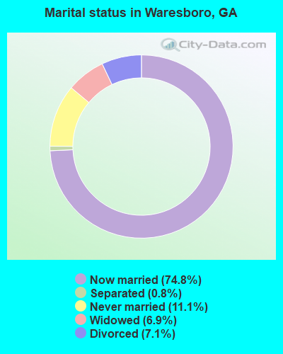
- Never married: 11.1%
- Now married: 74.8%
- Separated: 0.8%
- Widowed: 6.9%
- Divorced: 7.1%
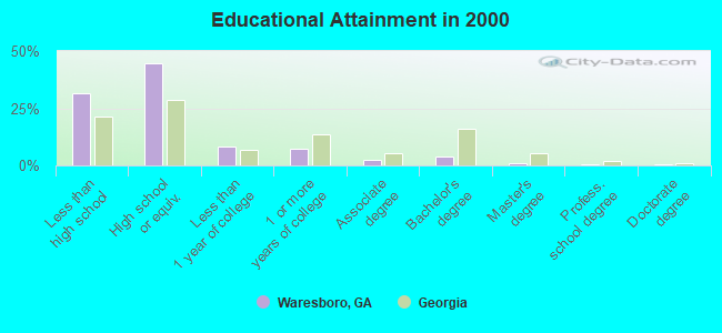
For population 25 years and over in Waresboro:
- High school or higher: 68.3%
- Bachelor's degree or higher: 5.8%
- Graduate or professional degree: 1.8%
- Unemployed: 5.1%
- Mean travel time to work (commute): 19.2 minutes
| Here: | 12.0 |
| Georgia average: | 13.3 |
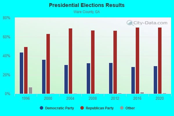
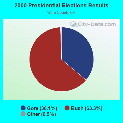

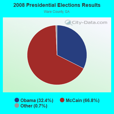


Graphs represent county-level data. Detailed 2008 Election Results
Religion statistics for Waresboro, GA (based on Ware County data)
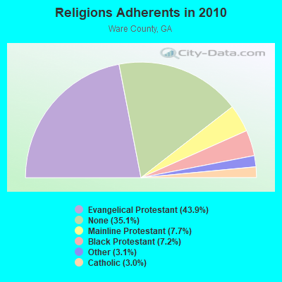
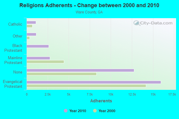
| Religion | Adherents | Congregations |
|---|---|---|
| Evangelical Protestant | 15,946 | 71 |
| Mainline Protestant | 2,778 | 15 |
| Black Protestant | 2,620 | 11 |
| Other | 1,123 | 3 |
| Catholic | 1,095 | 1 |
| None | 12,750 | - |
Food Environment Statistics:
| This county: | 2.51 / 10,000 pop. |
| Georgia: | 1.91 / 10,000 pop. |
| Ware County: | 0.28 / 10,000 pop. |
| Georgia: | 0.15 / 10,000 pop. |
| Here: | 1.40 / 10,000 pop. |
| Georgia: | 0.86 / 10,000 pop. |
| Here: | 9.77 / 10,000 pop. |
| Georgia: | 5.12 / 10,000 pop. |
| Ware County: | 5.31 / 10,000 pop. |
| State: | 7.41 / 10,000 pop. |
| This county: | 11.6% |
| State: | 10.4% |
| This county: | 28.2% |
| Georgia: | 27.8% |
| This county: | 13.1% |
| State: | 14.6% |
Strongest AM radio stations in Waresboro:
- WOKV (690 AM; 50 kW; JACKSONVILLE, FL; Owner: COX RADIO, INC.)
- WFVR (910 AM; 50 kW; VALDOSTA, GA; Owner: RAMA COMMUNICATIONS, INC.)
- WDMG (860 AM; 5 kW; DOUGLAS, GA; Owner: RTG RADIO, LLC)
- WFNS (1350 AM; 2 kW; BLACKSHEAR, GA; Owner: MARMAC COMMUNICATIONS, LLC)
- WOBS (1530 AM; daytime; 50 kW; JACKSONVILLE, FL; Owner: WORD BROADCASTING NETWORK, INC.)
- WGSR (1570 AM; 50 kW; FERNANDINA BEACH, FL; Owner: RJM COMMUNICATIONS, INC)
- WCGA (1100 AM; daytime; 10 kW; WOODBINE, GA; Owner: COX BROADCAST GROUP, INC.)
- WOKA (1310 AM; 4 kW; DOUGLAS, GA; Owner: COFFEE COUNTY BROADCASTERS, INC.)
- WSTT (730 AM; 25 kW; THOMASVILLE, GA; Owner: MARION R. WILLIAMS)
- WMAC (940 AM; 50 kW; MACON, GA; Owner: CUMULUS LICENSING CORP.)
- WUFE (1260 AM; daytime; 5 kW; BAXLEY, GA; Owner: SOUTH GEORGIA BROADCASTERS, INC.)
- WLOP (1370 AM; 5 kW; JESUP, GA; Owner: JESUP BROADCASTING CORP.)
- WFLF (540 AM; 50 kW; PINE HILLS, FL; Owner: CLEAR CHANNEL BROADCASTING LICENSES, INC.)
Strongest FM radio stations in Waresboro:
- WXVS (90.1 FM; WAYCROSS, GA; Owner: GEORGIA PUBLIC TELECOMMUNICATIONS COMMISSION)
- WWSN (103.3 FM; WAYCROSS, GA; Owner: QANTUM OF BRUNSWICK LICENSE COMPANY, LLC)
- WKUB (105.1 FM; BLACKSHEAR, GA; Owner: MATTOX BROADCASTING, INC.)
- WYNR (102.5 FM; WAYCROSS, GA; Owner: QANTUM OF BRUNSWICK LICENSE COMPANY, LLC)
- WOKA-FM (106.7 FM; DOUGLAS, GA; Owner: COFFEE COUNTY BROADCASTERS, INC.)
- WBYZ (94.5 FM; BAXLEY, GA; Owner: SOUTH GEORGIA BROADCASTERS, INC.)
- WPNG (101.9 FM; PEARSON, GA; Owner: KM RADIO OF PEARSON, L.L.C.)
- WWUF (97.7 FM; WAYCROSS, GA; Owner: MATTOX BROADCASTING, INC.)
- WAJQ-FM (104.3 FM; ALMA, GA; Owner: BLUEBERRY BROADCASTING COMPANY, INC.)
- WASW (91.9 FM; WAYCROSS, GA; Owner: AMERICAN FAMILY ASSOCIATION)
TV broadcast stations around Waresboro:
- WXGA-TV (Channel 8; WAYCROSS, GA; Owner: GEORGIA PUBLIC TELECOMMUNICATIONS COMMISSION)
- WPXC-TV (Channel 21; BRUNSWICK, GA; Owner: PAXSON JAX LICENSE, INC.)
- W54CW (Channel 54; WAYCROSS, GA; Owner: TRINITY BROADCASTING NETWORK, INC.)
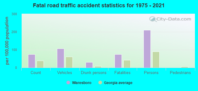
Waresboro fatal accident list:
Dec 23, 2017 00:01 AM, Ternest Road, Lat: 31.274469, Lon: -82.390011, Vehicles: 1, Persons: 1, Fatalities: 1, Drunk persons involved: 1
Jul 17, 2016 01:30 AM, Jamestown Road, Lat: 31.263972, Lon: -82.380778, Vehicles: 1, Persons: 1, Fatalities: 1
Oct 17, 2016 06:51 PM, Sr-4(Bus), Lat: 31.297594, Lon: -82.452361, Vehicles: 1, Persons: 1, Fatalities: 1, Drunk persons involved: 1
Apr 22, 2011 09:51 PM, Us-82 / Sr-520, Sr-4 Byp, Lat: 31.243042, Lon: -82.431286, Vehicles: 2, Persons: 9, Fatalities: 1
- National Bridge Inventory (NBI) Statistics
- 2Number of bridges
- 20ft / 5.8mTotal length
- $1,108,000Total costs
- 22,310Total average daily traffic
- 223Total average daily truck traffic
- 33,465Total future (year 2031) average daily traffic
FAA Registered Aircraft:
1- Aircraft: CESSNA 150J (Category: Land, Seats: 2, Weight: Up to 12,499 Pounds, Speed: 90 mph), Engine: CONT MOTOR 0-200 SERIES (100 HP) (Reciprocating)
N-Number: 50865, N50865, N-50865, Serial Number: 15069606, Year manufactured: 1968, Airworthiness Date: 10/07/1968, Certificate Issue Date: 04/04/2014
Registrant (Individual): Leslie A Smith, Po Box 36, Waresboro, GA 31564
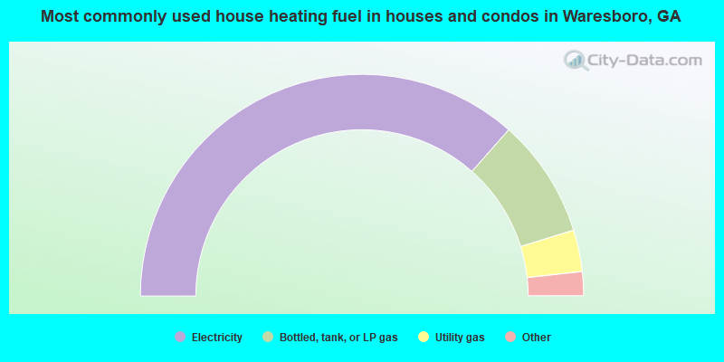
- 73.1%Electricity
- 17.4%Bottled, tank, or LP gas
- 6.1%Utility gas
- 2.3%Wood
- 0.8%Fuel oil, kerosene, etc.
- 0.4%No fuel used
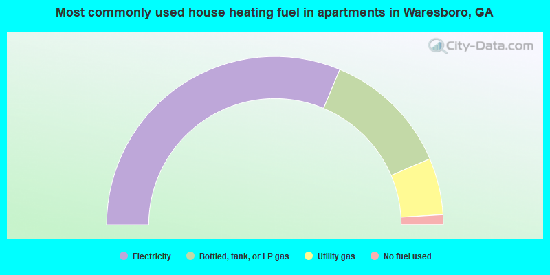
- 62.6%Electricity
- 24.6%Bottled, tank, or LP gas
- 10.9%Utility gas
- 1.9%No fuel used
Waresboro compared to Georgia state average:
- Median house value significantly below state average.
- Unemployed percentage significantly below state average.
- Black race population percentage below state average.
- Hispanic race population percentage significantly below state average.
- Foreign-born population percentage significantly below state average.
- Length of stay since moving in significantly above state average.
- Number of rooms per house significantly below state average.
- House age significantly below state average.
- Institutionalized population percentage significantly above state average.
- Number of college students below state average.
- Percentage of population with a bachelor's degree or higher significantly below state average.
Waresboro on our top lists:
- #1 on the list of "Top 101 cities with largest percentage of females in industries: repair and maintenance (population 5,000+)"
- #3 on the list of "Top 101 cities with largest percentage of females in occupations: electricians (population 5,000+)"
- #4 on the list of "Top 101 cities with largest percentage of males in industries: rail transportation (population 5,000+)"
- #9 on the list of "Top 101 cities with largest percentage of males in industries: beverage and tobacco products (population 5,000+)"
- #11 on the list of "Top 101 cities with largest percentage of females in industries: wood products (population 5,000+)"
- #12 on the list of "Top 101 cities with largest percentage of males in occupations: rail and water transportation workers (population 5,000+)"
- #12 on the list of "Top 101 cities with largest percentage of males in industries: farm product raw materials merchant wholesalers (population 5,000+)"
- #16 on the list of "Top 101 cities with largest percentage of males in occupations: other healthcare support occupations (population 5,000+)"
- #18 on the list of "Top 101 cities with largest percentage of females in industries: rail transportation (population 5,000+)"
- #22 on the list of "Top 101 cities with largest percentage of males in occupations: other sales and related workers including supervisors (population 5,000+)"
- #29 on the list of "Top 101 cities with largest percentage of males in occupations: other production occupations including supervisors (population 5,000+)"
- #30 on the list of "Top 101 cities with largest percentage of females in industries: department and other general merchandise stores (population 5,000+)"
- #34 on the list of "Top 101 cities with largest percentage of females in industries: u. s. postal service (population 5,000+)"
- #34 on the list of "Top 101 cities with largest percentage of males in industries: wood products (population 5,000+)"
- #38 on the list of "Top 101 cities with largest percentage of females in industries: pharmacies and drug stores (population 5,000+)"
- #39 on the list of "Top 101 cities with the largest percentage of people in short-term care, detention or diagnostic centers for delinquent children (population 1,000+)"
- #42 on the list of "Top 101 cities with largest percentage of females in occupations: textile, apparel, and furnishings workers (population 5,000+)"
- #42 on the list of "Top 101 cities with largest percentage of females in industries: apparel (population 5,000+)"
- #43 on the list of "Top 101 cities with largest percentage of females in industries: food and beverage stores (population 5,000+)"
- #44 on the list of "Top 101 cities with largest percentage of males in industries: sporting goods, camera, and hobby and toy stores (population 5,000+)"
- #90 on the list of "Top 101 counties with the smallest number of children under 18 without health insurance coverage in 2000"