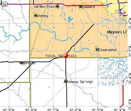
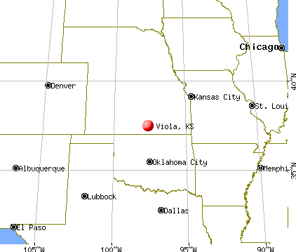
Viola, Kansas
Submit your own pictures of this city and show them to the world
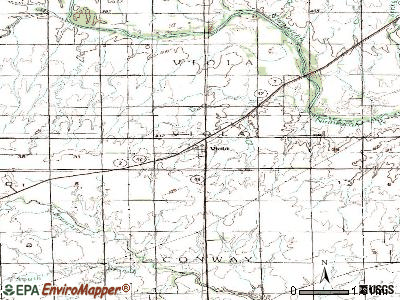
- OSM Map
- General Map
- Google Map
- MSN Map
Population change since 2000: -46.9%
| Males: 28 | |
| Females: 84 |
| Median resident age: | 45.5 years |
| Kansas median age: | 37.6 years |
Zip codes: 67149.
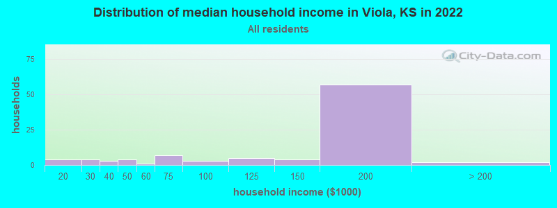
| Viola: | $172,678 |
| KS: | $68,925 |
Estimated per capita income in 2022: $49,386 (it was $16,804 in 2000)
Viola city income, earnings, and wages data
Estimated median house or condo value in 2022: $177,784 (it was $47,900 in 2000)
| Viola: | $177,784 |
| KS: | $206,600 |
Mean prices in 2022: all housing units: $140,011; detached houses: $152,406; mobile homes: $65,550
Detailed information about poverty and poor residents in Viola, KS
Compare current foreclosures near Viola, KS:
| Photo | Address | Area | Beds / Baths | Price | Details |
|---|---|---|---|---|---|

|
#1
N 5th St
Conway Springs, KS 67031
|
1,088 sq. feet
|
2 baths 3 beds |
$39,900
|
show details |

|
#2
N Covington St
Wichita, KS 67212
|
1,242 sq. feet
|
3 baths 3 beds |
show details | |

|
#3
Janet St
Clearwater, KS 67026
|
1,428 sq. feet
|
2 baths 4 beds |
show details | |

|
#4
S Melvin Ct
Haysville, KS 67060
|
1,468 sq. feet
|
2 baths 3 beds |
show details | |

|
#5
S Fawnwood St
Wichita, KS 67235
|
1,524 sq. feet
|
3 baths 3 beds |
show details | |

|
#6
W Kansas St
Conway Springs, KS 67031
|
1,760 sq. feet
|
2 baths 3 beds |
show details | |

|
#7
W 39th St S
Goddard, KS 67052
|
4,221 sq. feet
|
3 baths 3 beds |
show details | |

|
#8
S Prescott Cir
Wichita, KS 67209
|
1,820 sq. feet
|
3 baths 2 beds |
show details | |

|
#9
S Blue Stem St
Haysville, KS 67060
|
1,188 sq. feet
|
2 baths 3 beds |
show details | |

|
#10
S Blue Stem St
Haysville, KS 67060
|
1,046 sq. feet
|
2 baths 3 beds |
show details |
| Photo | Address | Area | Beds / Baths | Price | Details |
|---|---|---|---|---|---|

|
#11
W Merton St
Wichita, KS 67209
|
1,186 sq. feet
|
2 baths 3 beds |
show details | |

|
#12
S Boyd Ct
Wichita, KS 67215
|
936 sq. feet
|
2 baths 3 beds |
show details | |

|
#13
W Jewell St
Wichita, KS 67209
|
972 sq. feet
|
2 baths 2 beds |
show details | |

|
#14
W 4th St
Haysville, KS 67060
|
900 sq. feet
|
1 baths 2 beds |
show details | |

|
#15
N High St
Argonia, KS 67004
|
1,115 sq. feet
|
1 baths 4 beds |
show details | |

|
#16
Sunset Ave
Haysville, KS 67060
|
925 sq. feet
|
1 baths 2 beds |
show details | |

|
#17
Stearns Ave
Haysville, KS 67060
|
1,008 sq. feet
|
1 baths 3 beds |
show details | |

|
#18
W 5th St
Haysville, KS 67060
|
864 sq. feet
|
1 baths 3 beds |
show details | |

|
#19
Turkle Ave
Haysville, KS 67060
|
1,002 sq. feet
|
1 baths 3 beds |
show details | |

|
#20
Anita Dr
Haysville, KS 67060
|
1,380 sq. feet
|
1 baths 2 beds |
show details |
| Photo | Address | Area | Beds / Baths | Price | Details |
|---|---|---|---|---|---|

|
#21
S Lamar Ave
Haysville, KS 67060
|
910 sq. feet
|
1 baths 2 beds |
show details | |

|
#22
W Yosemite Ct
Wichita, KS 67215
|
2,240 sq. feet
|
3 baths 4 beds |
show details | |

|
#23
S Covington Ct
Wichita, KS 67209
|
2,712 sq. feet
|
3 baths 4 beds |
show details | |

|
#24
Rainier Ct
Wichita, KS 67215
|
1,188 sq. feet
|
2 baths 3 beds |
show details | |

|
#25
S Lark Ln
Wichita, KS 67215
|
1,366 sq. feet
|
3 baths 3 beds |
show details | |

|
#26
W Grant St
Wichita, KS 67209
|
1,949 sq. feet
|
3 baths 3 beds |
show details | |

|
#27
S Maize Rd
Wichita, KS 67215
|
1,400 sq. feet
|
1 baths 2 beds |
show details | |

|
#28
Fairfield St
Norwich, KS 67118
|
995 sq. feet
|
1 baths 2 beds |
show details | |

|
#29
E Winterset St
Goddard, KS 67052
|
816 sq. feet
|
1 baths 2 beds |
show details | |

|
#30
E 4th Ave Apt 1
Cheney, KS 67025
|
- sq. feet
|
- baths - beds |
show details |
| Photo | Address | Area | Beds / Baths | Price | Details |
|---|---|---|---|---|---|

|
#31
W 45th St S
Wichita, KS 67217
|
- sq. feet
|
- baths - beds |
show details | |

|
#32
W 44th St S Lot 205
Wichita, KS 67217
|
- sq. feet
|
- baths - beds |
show details | |

|
#33
W 44th St S Lot 344
Wichita, KS 67217
|
- sq. feet
|
- baths - beds |
show details | |

|
#34
W 55th St S
Clearwater, KS 67026
|
- sq. feet
|
- baths - beds |
show details | |

|
#35
S Lark Ln
Wichita, KS 67209
|
- sq. feet
|
- baths - beds |
show details | |

|
#36
SE 110 St
Norwich, KS 67118
|
- sq. feet
|
- baths - beds |
show details | |

|
#37
W Jennie St
Wichita, KS 67235
|
- sq. feet
|
- baths - beds |
show details | |

|
#38
W Angel St
Wichita, KS 67217
|
- sq. feet
|
- baths - beds |
show details | |

|
#39
German Ave
Haysville, KS 67060
|
- sq. feet
|
- baths - beds |
show details | |

|
#40
Martens Ct
Goddard, KS 67052
|
- sq. feet
|
- baths - beds |
show details |
| Photo | Address | Area | Beds / Baths | Price | Details |
|---|---|---|---|---|---|

|
#41
N Main St
Goddard, KS 67052
|
- sq. feet
|
- baths - beds |
show details | |

|
#42
W Maple St # 37
Goddard, KS 67052
|
- sq. feet
|
4 baths - beds |
show details | |

|
#43
S Gilda Ct
Wichita, KS 67215
|
- sq. feet
|
- baths - beds |
show details | |

|
#44
W Red Rock St
Wichita, KS 67235
|
- sq. feet
|
- baths - beds |
show details | |

|
#45
S Fairlawn St
Wichita, KS 67215
|
- sq. feet
|
- baths - beds |
show details | |

|
#46
W Grant Ct
Wichita, KS 67235
|
- sq. feet
|
- baths - beds |
show details | |

|
#47
W Maple St Lot D
Goddard, KS 67052
|
- sq. feet
|
- baths - beds |
show details | |

|
#48
S Westgate St
Wichita, KS 67215
|
- sq. feet
|
- baths - beds |
show details | |

|
#49
W 71st St S
Haysville, KS 67060
|
- sq. feet
|
- baths - beds |
show details | |

|
Check over 1 million property listings on Foreclosure.com!
|
browse all offers | |||


- 13867.6%White alone
- 4220.6%American Indian alone

Races in Viola detailed stats: ancestries, foreign born residents, place of birth
According to our research of Kansas and other state lists, there was 1 registered sex offender living in Viola, Kansas as of May 23, 2024.
The ratio of all residents to sex offenders in Viola is 124 to 1.
 Recent articles from our blog. Our writers, many of them Ph.D. graduates or candidates, create easy-to-read articles on a wide variety of topics.

Latest news from Viola, KS collected exclusively by city-data.com from local newspapers, TV, and radio stations
Ancestries: German (12.9%), American (9.9%), English (4.0%), Irish (2.0%), Italian (2.0%), Scottish (2.0%).
Current Local Time: CST time zone
Elevation: 1335 feet
Land area: 0.16 square miles.
Population density: 707 people per square mile (low).
3 residents are foreign born
| This city: | 1.4% |
| Kansas: | 5.0% |
Median real estate property taxes paid for housing units with mortgages in 2022: $4,811 (2.6%)
Median real estate property taxes paid for housing units with no mortgage in 2022: $1,332 (1.8%)
Nearest city with pop. 50,000+: Wichita, KS  (22.1 miles , pop. 344,284).
Nearest city with pop. 1,000,000+: Dallas, TX (327.6 miles , pop. 1,188,580).
Nearest cities:
), ), ), Latitude: 37.48 N, Longitude: 97.64 W

| Here: | 2.4% |
| Kansas: | 2.0% |
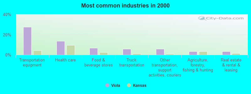
- Transportation equipment (27.6%)
- Health care (13.8%)
- Food & beverage stores (6.9%)
- Truck transportation (5.7%)
- Other transportation, support activities, couriers (5.7%)
- Agriculture, forestry, fishing & hunting (3.4%)
- Real estate & rental & leasing (3.4%)
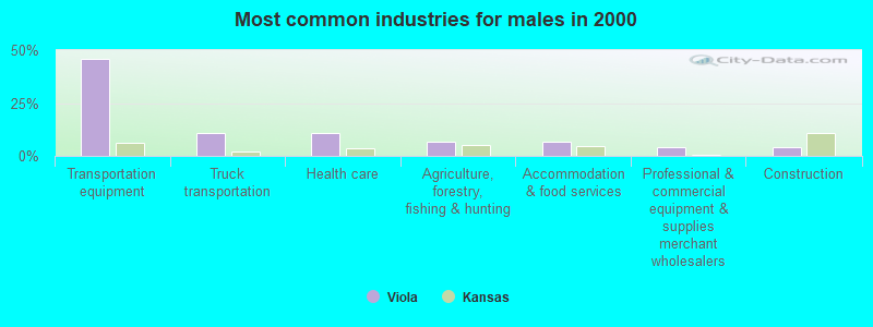
- Transportation equipment (45.7%)
- Truck transportation (10.9%)
- Health care (10.9%)
- Agriculture, forestry, fishing & hunting (6.5%)
- Accommodation & food services (6.5%)
- Professional & commercial equipment & supplies merchant wholesalers (4.3%)
- Construction (4.3%)
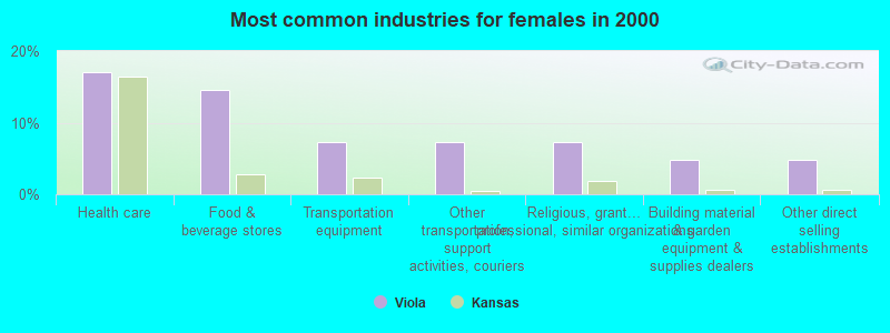
- Health care (17.1%)
- Food & beverage stores (14.6%)
- Transportation equipment (7.3%)
- Other transportation, support activities, couriers (7.3%)
- Religious, grantmaking, civic, professional, similar organizations (7.3%)
- Building material & garden equipment & supplies dealers (4.9%)
- Other direct selling establishments (4.9%)

- Construction traders workers except carpenters, electricians, painters, plumbers, and construction laborers (12.6%)
- Other management occupations, except farmers and farm managers (8.0%)
- Cashiers (6.9%)
- Other production occupations, including supervisors (6.9%)
- Nursing, psychiatric, and home health aides (5.7%)
- Vehicle and mobile equipment mechanics, installers, and repairers (5.7%)
- Sales representatives, services, wholesale and manufacturing (4.6%)

- Construction traders workers except carpenters, electricians, painters, plumbers, and construction laborers (23.9%)
- Other production occupations, including supervisors (13.0%)
- Vehicle and mobile equipment mechanics, installers, and repairers (10.9%)
- Sales representatives, services, wholesale and manufacturing (8.7%)
- Electrical equipment mechanics and other installation, maintenance, and repair workers, including supervisors (8.7%)
- Nursing, psychiatric, and home health aides (6.5%)
- Other management occupations, except farmers and farm managers (6.5%)

- Cashiers (14.6%)
- Other management occupations, except farmers and farm managers (9.8%)
- Other sales and related occupations, including supervisors (9.8%)
- Child care workers (7.3%)
- Material recording, scheduling, dispatching, and distributing workers (7.3%)
- Bus drivers (7.3%)
- Accountants and auditors (4.9%)
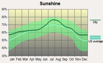
Average climate in Viola, Kansas
Based on data reported by over 4,000 weather stations


(lower is better)

Air Quality Index (AQI) level in 2022 was 83.4. This is about average.
| City: | 83.4 |
| U.S.: | 72.6 |

Carbon Monoxide (CO) [ppm] level in 2013 was 0.252. This is about average. Closest monitor was 15.3 miles away from the city center.
| City: | 0.252 |
| U.S.: | 0.251 |

Nitrogen Dioxide (NO2) [ppb] level in 2022 was 4.06. This is better than average. Closest monitor was 13.0 miles away from the city center.
| City: | 4.06 |
| U.S.: | 5.11 |

Sulfur Dioxide (SO2) [ppb] level in 2022 was 1.02. This is significantly better than average. Closest monitor was 13.0 miles away from the city center.
| City: | 1.02 |
| U.S.: | 1.51 |

Ozone [ppb] level in 2022 was 32.2. This is about average. Closest monitor was 15.3 miles away from the city center.
| City: | 32.2 |
| U.S.: | 33.3 |

Particulate Matter (PM10) [µg/m3] level in 2022 was 28.1. This is significantly worse than average. Closest monitor was 19.4 miles away from the city center.
| City: | 28.1 |
| U.S.: | 19.2 |

Particulate Matter (PM2.5) [µg/m3] level in 2022 was 9.19. This is about average. Closest monitor was 15.3 miles away from the city center.
| City: | 9.19 |
| U.S.: | 8.11 |
Tornado activity:
Viola-area historical tornado activity is slightly above Kansas state average. It is 111% greater than the overall U.S. average.
On 4/26/1991, a category F5 (max. wind speeds 261-318 mph) tornado 9.1 miles away from the Viola city center killed 17 people and injured 225 people and caused between $50,000,000 and $500,000,000 in damages.
On 3/13/1990, a category F5 tornado 28.5 miles away from the city center killed one person and injured 60 people and caused between $5,000,000 and $50,000,000 in damages.
Earthquake activity:
Viola-area historical earthquake activity is significantly above Kansas state average. It is 865% greater than the overall U.S. average.On 9/3/2016 at 12:02:44, a magnitude 5.8 (5.8 MW, Depth: 3.5 mi, Class: Moderate, Intensity: VI - VII) earthquake occurred 83.2 miles away from Viola center
On 11/6/2011 at 03:53:10, a magnitude 5.7 (5.7 MW, Depth: 3.2 mi) earthquake occurred 143.6 miles away from the city center
On 11/12/2014 at 21:40:00, a magnitude 4.9 (4.9 MW, Depth: 2.5 mi, Class: Light, Intensity: IV - V) earthquake occurred 14.7 miles away from the city center
On 2/13/2016 at 17:07:06, a magnitude 5.1 (5.1 MW, Depth: 5.2 mi) earthquake occurred 90.4 miles away from the city center
On 11/7/2016 at 01:44:24, a magnitude 5.0 (5.0 MW, Depth: 2.8 mi) earthquake occurred 113.3 miles away from Viola center
On 11/30/2015 at 09:49:12, a magnitude 4.7 (4.7 MW, Depth: 3.5 mi) earthquake occurred 55.5 miles away from the city center
Magnitude types: moment magnitude (MW)
Natural disasters:
The number of natural disasters in Sedgwick County (16) is near the US average (15).Major Disasters (Presidential) Declared: 12
Emergencies Declared: 3
Causes of natural disasters: Floods: 8, Storms: 8, Tornadoes: 3, Winter Storms: 3, Explosion: 1, Heavy Rain: 1, Hurricane: 1, Ice Storm: 1, Wind: 1, Other: 1 (Note: some incidents may be assigned to more than one category).
Hospitals and medical centers near Viola:
- SPRING VIEW MANOR (Nursing Home, about 7 miles away; CONWAY SPRINGS, KS)
- CLEARWATER NURSING AND REHABILITATION CENTER (Nursing Home, about 9 miles away; CLEARWATER, KS)
- NORWICH CARE CENTER INC (Nursing Home, about 12 miles away; NORWICH, KS)
- MEDICALODGES GODDARD (Nursing Home, about 13 miles away; GODDARD, KS)
- CHENEY GOLDEN AGE HOME (Nursing Home, about 13 miles away; CHENEY, KS)
Colleges/universities with over 2000 students nearest to Viola:
- Wichita Technical Institute (about 20 miles; Wichita, KS; Full-time enrollment: 2,015)
- Newman University (about 20 miles; Wichita, KS; FT enrollment: 2,066)
- Friends University (about 21 miles; Wichita, KS; FT enrollment: 2,024)
- Wichita State University (about 25 miles; Wichita, KS; FT enrollment: 11,743)
- Wichita Area Technical College (about 31 miles; Wichita, KS; FT enrollment: 2,220)
- Hutchinson Community College (about 44 miles; Hutchinson, KS; FT enrollment: 4,174)
- Cowley County Community College (about 45 miles; Arkansas City, KS; FT enrollment: 3,173)
Points of interest:
Notable locations in Viola: Viola Wastewater Treatment Facility (A), Viola Township Library (B), Viola Fire Station 65 (C). Display/hide their locations on the map
Churches in Viola include: Viola Presbyterian Church (A), Viola Baptist Church (B). Display/hide their locations on the map
Cemetery: Viola Cemetery (1). Display/hide its location on the map
Drinking water stations with addresses in Viola and their reported violations in the past:
YMCA CAMP HYDE INC (Population served: 300, Groundwater):Past health violations:Past monitoring violations:
- MCL, Monthly (TCR) - In SEP-2013, Contaminant: Coliform. Follow-up actions: St Public Notif requested (OCT-01-2013), St Violation/Reminder Notice (OCT-01-2013), St Compliance achieved (OCT-31-2013), St Public Notif received (NOV-04-2013)
- 2 routine major monitoring violations
- 6 minor monitoring violations
| This city: | 2.5 people |
| Kansas: | 2.5 people |
| This city: | 72.5% |
| Whole state: | 66.0% |
| This city: | 5.9% |
| Whole state: | 5.8% |
No gay or lesbian households reported
For population 15 years and over in Viola:

- Never married: 41.9%
- Now married: 47.8%
- Separated: 0.0%
- Widowed: 5.9%
- Divorced: 4.3%
For population 25 years and over in Viola:
- High school or higher: 95.7%
- Bachelor's degree or higher: 41.3%
- Graduate or professional degree: 1.1%
- Mean travel time to work (commute): 21.1 minutes


| Here: | 7.5 |
| Kansas average: | 11.5 |
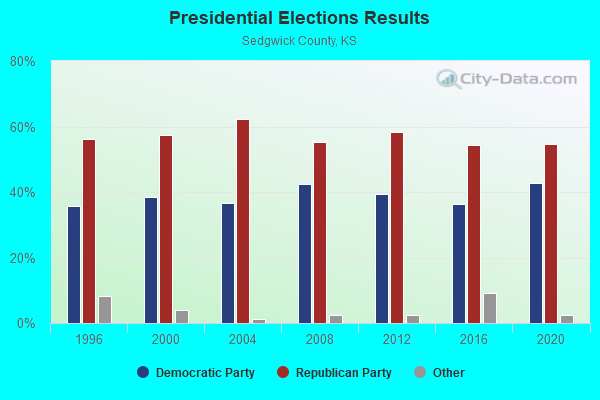
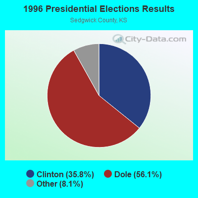
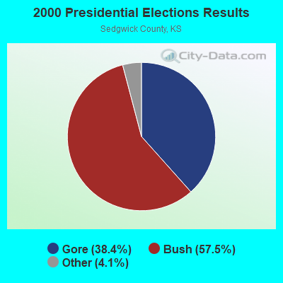
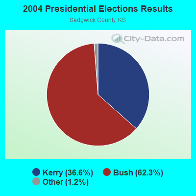
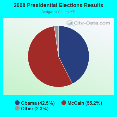
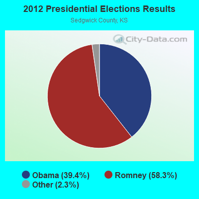
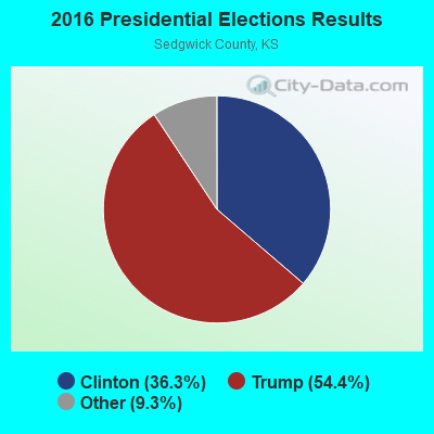

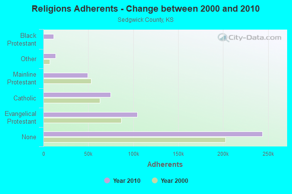
Graphs represent county-level data. Detailed 2008 Election Results
Religion statistics for Viola, KS (based on Sedgwick County data)
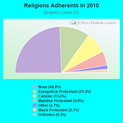
| Religion | Adherents | Congregations |
|---|---|---|
| Evangelical Protestant | 104,418 | 317 |
| Catholic | 74,600 | 32 |
| Mainline Protestant | 49,200 | 118 |
| Other | 13,532 | 47 |
| Black Protestant | 11,312 | 28 |
| Orthodox | 1,361 | 4 |
| None | 243,942 | - |
Food Environment Statistics:
| This county: | 1.33 / 10,000 pop. |
| State: | 1.96 / 10,000 pop. |
| Here: | 0.13 / 10,000 pop. |
| State: | 0.20 / 10,000 pop. |
| Sedgwick County: | 0.34 / 10,000 pop. |
| Kansas: | 0.51 / 10,000 pop. |
| Here: | 2.38 / 10,000 pop. |
| Kansas: | 3.84 / 10,000 pop. |
| This county: | 6.44 / 10,000 pop. |
| Kansas: | 7.33 / 10,000 pop. |
| Sedgwick County: | 8.7% |
| State: | 8.1% |
| This county: | 28.3% |
| State: | 27.9% |
| Sedgwick County: | 16.5% |
| Kansas: | 13.4% |
Health and Nutrition:
| Here: | 49.3% |
| State: | 49.2% |
| This city: | 39.9% |
| State: | 46.3% |
| Here: | 28.0 |
| Kansas: | 28.6 |
| Here: | 15.5% |
| Kansas: | 21.2% |
| Viola: | 7.1 |
| Kansas: | 6.8 |
| This city: | 20.6% |
| Kansas: | 33.5% |
| Here: | 50.7% |
| State: | 56.0% |
| Viola: | 83.7% |
| State: | 78.6% |
More about Health and Nutrition of Viola, KS Residents
| Local government employment and payroll (March 2022) | |||||
| Function | Full-time employees | Monthly full-time payroll | Average yearly full-time wage | Part-time employees | Monthly part-time payroll |
|---|---|---|---|---|---|
| Other Government Administration | 0 | $0 | 4 | $2,758 | |
| Water Supply | 0 | $0 | 1 | $788 | |
| Financial Administration | 0 | $0 | 1 | $837 | |
| Totals for Government | 0 | $0 | 6 | $4,384 | |
Viola government finances - Expenditure in 2017 (per resident):
- Current Operations - Gas Utilities: $37,000 ($330.36)
Water Utilities: $33,000 ($294.64)
Central Staff Services: $13,000 ($116.07)
Solid Waste Management: $11,000 ($98.21)
General - Other: $10,000 ($89.29)
Sewerage: $10,000 ($89.29)
Local Fire Protection: $9,000 ($80.36)
Regular Highways: $4,000 ($35.71)
- General - Interest on Debt: $4,000 ($35.71)
- Total Salaries and Wages: $24,000 ($214.29)
Viola government finances - Revenue in 2017 (per resident):
- Charges - Solid Waste Management: $14,000 ($125.00)
Sewerage: $9,000 ($80.36)
- Local Intergovernmental - General Local Government Support: $17,000 ($151.79)
- Miscellaneous - General Revenue - Other: $1,000 ($8.93)
Interest Earnings: $1,000 ($8.93)
- Revenue - Water Utilities: $44,000 ($392.86)
Gas Utilities: $41,000 ($366.07)
- State Intergovernmental - Highways: $3,000 ($26.79)
- Tax - Property: $13,000 ($116.07)
Public Utilities Sales: $2,000 ($17.86)
Other License: $1,000 ($8.93)
Viola government finances - Cash and Securities in 2017 (per resident):
- Other Funds - Cash and Securities: $184,000 ($1642.86)
4.59% of this county's 2021 resident taxpayers lived in other counties in 2020 ($63,222 average adjusted gross income)
| Here: | 4.59% |
| Kansas average: | 6.64% |
0.03% of residents moved from foreign countries ($380 average AGI)
Sedgwick County: 0.03% Kansas average: 0.04%
Top counties from which taxpayers relocated into this county between 2020 and 2021:
| from Butler County, KS | |
| from Reno County, KS | |
| from Harvey County, KS |
4.79% of this county's 2020 resident taxpayers moved to other counties in 2021 ($59,492 average adjusted gross income)
| Here: | 4.79% |
| Kansas average: | 6.88% |
0.03% of residents moved to foreign countries ($328 average AGI)
Sedgwick County: 0.03% Kansas average: 0.03%
Top counties to which taxpayers relocated from this county between 2020 and 2021:
| to Butler County, KS | |
| to Johnson County, KS | |
| to Sumner County, KS |
Businesses in Viola, KS
- YMCA: 1
Strongest AM radio stations in Viola:
- KFTI (1070 AM; 10 kW; WICHITA, KS; Owner: JOURNAL BROADCAST CORPORATION)
- KMYR (1410 AM; 5 kW; WICHITA, KS; Owner: AGAPE COMMUNICATIONS, INC.)
- KFH (1330 AM; 5 kW; WICHITA, KS; Owner: ENTERCOM WICHITA LICENSE, LLC)
- KQAM (1480 AM; 5 kW; WICHITA, KS; Owner: ABC, INC.)
- KRMG (740 AM; 50 kW; TULSA, OK; Owner: CXR HOLDINGS, INC.)
- KFAQ (1170 AM; 50 kW; TULSA, OK; Owner: JOURNAL BROADCAST CORPORATION)
- KOMA (1520 AM; 50 kW; OKLAHOMA CITY, OK; Owner: RENDA BROADCASTING CORP. OF NEVADA)
- WHB (810 AM; 50 kW; KANSAS CITY, MO; Owner: UNION BROADCASTING, INC.)
- KCRC (1390 AM; 10 kW; ENID, OK; Owner: CHISHOLM TRAIL BROADCASTING CO.)
- KWLS (1290 AM; 5 kW; PRATT, KS; Owner: WAITT RADIO, INC.)
- KTBZ (1430 AM; 25 kW; TULSA, OK; Owner: CLEAR CHANNEL BROADCASTING LICENSES, INC.)
- KRVN (880 AM; 50 kW; LEXINGTON, NE; Owner: NEBRASKA RURAL RADIO ASSOCIATION)
- KMUS (1380 AM; 20 kW; MUSKOGEE, OK; Owner: ABC, INC.)
Strongest FM radio stations in Viola:
- KFH-FM (98.7 FM; CLEARWATER, KS; Owner: ENTERCOM WICHITA LICENSE, LLC)
- KANR (92.7 FM; BELLE PLAINE, KS; Owner: DANIEL D. SMITH)
- KFDI-FM (101.3 FM; WICHITA, KS; Owner: JOURNAL BROADCAST CORPORATION)
- KRBB (97.9 FM; WICHITA, KS; Owner: CAPSTAR TX LIMITED PARTNERSHIP)
- KFBZ (105.3 FM; HAYSVILLE, KS; Owner: ENTERCOM WICHITA LICENSE, LLC)
- KZSN (102.1 FM; HUTCHINSON, KS; Owner: CAPSTAR TX LIMITED PARTNERSHIP)
- KICT-FM (95.1 FM; WICHITA, KS; Owner: JOURNAL BROADCAST CORPORATION)
- KEYN-FM (103.7 FM; WICHITA, KS; Owner: ENTERCOM WICHITA LICENSE, LLC)
- KKRD (107.3 FM; WICHITA, KS; Owner: CAPSTAR TX LIMITED PARTNERSHIP)
- KYQQ (106.5 FM; ARKANSAS CITY, KS; Owner: JOURNAL BROADCAST CORPORATION)
- KHCC-FM (90.1 FM; HUTCHINSON, KS; Owner: HUTCHINSON COMMUNITY JR. COLLEGE)
- KRZZ-FM (96.3 FM; DERBY, KS; Owner: CAPSTAR TX LIMITED PARTNERSHIP)
- KZZD (90.7 FM; WICHITA, KS; Owner: WORD OF LIFE MINISTRIES, INC.)
- KDGS (93.9 FM; ANDOVER, KS; Owner: ENTERCOM WICHITA LICENSE, LLC)
- KWME (93.5 FM; WELLINGTON, KS; Owner: JOHNSON ENTERPRISES, INC.)
- KCVW (94.3 FM; KINGMAN, KS; Owner: COMMUNITY BROADCASTING, INC.)
- KSKU (97.1 FM; HUTCHINSON, KS; Owner: AD ASTRA PER ASPERA BROADCASTING, IN)
- KTCM (100.3 FM; KINGMAN, KS; Owner: MARIA L. SALAZAR)
- KMUW (89.1 FM; WICHITA, KS; Owner: WICHITA STATE UNIVERSITY)
TV broadcast stations around Viola:
- KSNW (Channel 3; WICHITA, KS; Owner: EMMIS TELEVISION LICENSE CORPORATION OF WICHITA)
- KSAS-TV (Channel 24; WICHITA, KS; Owner: CLEAR CHANNEL BROADCASTING LICENSES, INC.)
- KWCV (Channel 33; WICHITA, KS; Owner: WLBB BROADCASTING, L.L.C.)
- KAKE-TV (Channel 10; WICHITA, KS; Owner: GRAY MIDAMERICA TV LICENSEE CORP.)
- KCTU-LP (Channel 55; WICHITA, KS; Owner: RIVER CITY BROADCASTING CORP.)
- KSMI-LP (Channel 51; WICHITA, KS; Owner: RIVER CITY BROADCASTING CORP.)
- KTQW-LP (Channel 53; WICHITA, KS; Owner: KNOWLEDGE L.C.)
- KSCC (Channel 36; HUTCHINSON, KS; Owner: MERCURY BROADCASTING COMPANY, INC.)
- KWCH-TV (Channel 12; HUTCHINSON, KS; Owner: MEDIA GENERAL BROADCASTING OF SO. CAROLINA HOLDINGS, INC.)
- KPTS (Channel 8; HUTCHINSON, KS; Owner: KANSAS PUBLIC TELECOMMUNICATIONS SERVICE, INC.)
- KFVT-LP (Channel 40; WICHITA, KS; Owner: LOCKE SUPPLY CO.)
- K59DA (Channel 59; WICHITA, KS; Owner: TRINITY BROADCASTING NETWORK)
- K15DD (Channel 15; WICHITA, KS; Owner: VENTANA TELEVISION, INC.)
- National Bridge Inventory (NBI) Statistics
- 21Number of bridges
- 285ft / 86.6mTotal length
- 32,381Total average daily traffic
- 4,132Total average daily truck traffic
- 44,245Total future (year 2038) average daily traffic

- New bridges - historical statistics
- 21940-1949
- 31950-1959
- 11960-1969
- 21970-1979
- 31980-1989
- 21990-1999
- 62000-2009
- 22010-2019
FCC Registered Antenna Towers:
4- Carol Kuhn, Clonmel Yard 17500 W 71st St South (Lat: 37.564944 Lon: -97.541639), Type: 91.4, Structure height: 20173 m, Overall height: 91.4 m, Licensee ID: C, Registrant: Black & Veatch Telecommunications Division, Hatfieldl@bv.Com, , Overl-and Park, Phone: (913) 458-2460
- Laura E Hatfield, Clonmel Yard 17500 W 71st St South (Lat: 37.564944 Lon: -97.541639), Type: 91.4, Structure height: 20173 m, Overall height: 91.4 m, Registrant: K&k Environmental LLC, Kk_environmental@prodigy.Net, , Leave-nworth, Phone: (913) 724-5800
- Clonmel Yard 17500 W 71st St South (Lat: 37.564944 Lon: -97.541639), Type: 91.4, Structure height: 20173 m, Overall height: 91.4 m, Registrant: K&k Environmental LLC, Kk_environmental@prodigy.Net, , Leave-nworth, Phone: (913) 724-5800
- Laura E Hatfield, Clonmel Yard 17500 W 71st St South (Lat: 37.564944 Lon: -97.541639), Type: 91.4, Structure height: 20173 m, Overall height: 91.4 m, Registrant: K&k Environmental LLC, Kk_environmental@prodigy.Net, , Leave-nworth, Phone: (913) 724-5800
FCC Registered Broadcast Land Mobile Towers:
2- 206 S Main St (Lat: 37.482806 Lon: -97.644778), Call Sign: WSZ58, Licensee ID: L00007831,
Assigned Frequencies: 153.890 MHz, 154.385 MHz, Grant Date: 03/05/1996, Expiration Date: 04/22/2001, Cancellation Date: 06/24/2001, Registrant: County Of Sedgwick, 1901 N Market, Wichita, KS 67214, Phone: (316) 383-7081
- CLONMEL YARD, 17500 W 71st St S (Lat: 37.564944 Lon: -97.541639), Type: Ltower, Structure height: 91.4 m, Call Sign: WQRB981,
Assigned Frequencies: 854.387 MHz, 855.287 MHz, 856.262 MHz, 856.462 MHz, 856.737 MHz, 856.962 MHz, 857.262 MHz, 857.462 MHz, 857.737 MHz, 857.962 MHz... (+9 more), Grant Date: 03/03/2023, Expiration Date: 04/12/2033, Certifier: Jerad A Wilson, Registrant: Cassidian Communications / Eads North America Co, 1301 W President George Bush Hwy Ste 150, Richardson, TX 75080-1146, Phone: (469) 323-1975, Fax: (972) 398-7844, Email:
FCC Registered Microwave Towers:
3- NINNESCAH RIVER, 21480 West 95th St (Lat: 37.521500 Lon: -97.586611), Type: Pole, Structure height: 49.4 m, Overall height: 51.8 m, Call Sign: WQIT661,
Assigned Frequencies: 6034.15 MHz, Grant Date: 05/12/2008, Expiration Date: 05/12/2018, Cancellation Date: 11/12/2009, Certifier: William Chastain, Registrant: Radio Dynamics Corporation, Silver Spring, MD 20914, Phone: (301) 493-5171, Fax: (301) 576-4553, Email:
- CLONMEL, Clonmel Yard 17500 W 71st St South (Lat: 37.564944 Lon: -97.541639), Type: Ltower, Structure height: 91.4 m, Call Sign: WQRK866,
Assigned Frequencies: 6063.80 MHz, 6093.45 MHz, 5945.20 MHz, 6004.50 MHz, 6063.80 MHz, 6093.45 MHz, 5945.20 MHz, 6004.50 MHz, 6063.80 MHz, 6093.45 MHz... (+6 more), Grant Date: 06/28/2023, Expiration Date: 06/07/2033, Certifier: Jerad Wilson, Registrant: Comsearch, 19700 Janelia Farm Blvd, Ashburn, VA 20147, Phone: (703) 726-5671
- KS-CLONMEL-C, 18402 W 71st (Lat: 37.563389 Lon: -97.553417), Type: Silo, Structure height: 48.8 m, Call Sign: WRHY456,
Assigned Frequencies: 11245.0 MHz, 11245.0 MHz, 11245.0 MHz, 11245.0 MHz, 11245.0 MHz, 11245.0 MHz, 11245.0 MHz, 11245.0 MHz, 11245.0 MHz, 11245.0 MHz... (+20 more), Grant Date: 07/14/2020, Expiration Date: 07/14/2030, Certifier: Derrick Brown, Registrant: Amg Technology Investment Group, LLC, 95 Parker Oaks Lane, Hudson Oaks, TX 76087, Phone: (855) 698-5465, Email:
FCC Registered Amateur Radio Licenses:
3- Call Sign: KA0ZZS, Licensee ID: L01259796, Grant Date: 08/21/2007, Expiration Date: 11/17/2017, Cancellation Date: 11/19/2019, Registrant: Charles A Steen, 24810 W 111th St S, Viola, KS 67149
- Call Sign: N5SQZ, Licensee ID: L00306760, Grant Date: 01/27/2021, Expiration Date: 04/02/2031, Registrant: Paul J Howerton, 8707 Harvest Valley Dr, Viola, KS 67149-8700
- Call Sign: KC0LET, Licensee ID: L00388342, Grant Date: 08/05/2021, Expiration Date: 08/10/2031, Certifier: Evan A Seiwert, Registrant: Evan A Seiwert, 27516 W 103rd St S, Viola, KS 67149
FAA Registered Aircraft:
3- Aircraft: COLLINS JAMES SR CH 701 STOL (Category: Land, Seats: 2, Weight: Up to 12,499 Pounds), Engine: JABIRU 2200 (85 HP) (Reciprocating)
N-Number: 1011V, N1011V, N-1011V, Serial Number: 75288, Year manufactured: 2007, Airworthiness Date: 05/18/2012, Certificate Issue Date: 09/21/2018
Registrant (Individual): Alan D Weiss, 22930 W K42 Hwy, Viola, KS 67149 - Aircraft: WALDHAUS ROBERT N ESCAPADE (Category: Land, Weight: Up to 12,499 Pounds), Engine: ROTAX 912ULS SERIES (100 HP) (Reciprocating)
N-Number: 556AW, N556AW, N-556AW, Serial Number: JAESC0069, Year manufactured: 2006, Airworthiness Date: 03/17/2016, Certificate Issue Date: 08/11/2016
Registrant (Individual): Alan D Weiss, 22930 W State Road 42, Viola, KS 67149 - Aircraft: CESSNA 182P (Category: Land, Seats: 4, Weight: Up to 12,499 Pounds, Speed: 120 mph), Engine: CONT MOTOR O-470 SERIES (230 HP) (Reciprocating)
N-Number: 5984J, N5984J, N-5984J, Serial Number: 18263599, Year manufactured: 1975, Airworthiness Date: 02/07/1975, Certificate Issue Date: 09/18/1982
Registrant (Corporation): Zogleman Enterprises Inc, 18900 W 87th St S, Viola, KS 67149
2002 - 2018 National Fire Incident Reporting System (NFIRS) incidents
- Fire incident types reported to NFIRS in Viola, KS
- 12869.2%Outside Fires
- 3518.9%Structure Fires
- 2010.8%Mobile Property/Vehicle Fires
- 21.1%Other
 Based on the data from the years 2002 - 2018 the average number of fires per year is 11. The highest number of fires - 19 took place in 2014, and the least - 6 in 2004. The data has a decreasing trend.
 When looking into fire subcategories, the most reports belonged to: Outside Fires (69.2%), and Structure Fires (18.9%).
| Most common first names in Viola, KS among deceased individuals | ||
| Name | Count | Lived (average) |
|---|---|---|
| William | 7 | 74.6 years |
| John | 6 | 82.8 years |
| Albert | 5 | 76.2 years |
| Mary | 5 | 89.0 years |
| Robert | 4 | 79.5 years |
| Walter | 4 | 78.8 years |
| Ethel | 3 | 83.4 years |
| Henry | 3 | 69.7 years |
| Edward | 3 | 81.6 years |
| James | 3 | 70.0 years |
| Most common last names in Viola, KS among deceased individuals | ||
| Last name | Count | Lived (average) |
|---|---|---|
| Porter | 6 | 84.3 years |
| Hoheisel | 4 | 84.0 years |
| Pauly | 4 | 77.2 years |
| Nighswonger | 4 | 77.2 years |
| Simon | 4 | 68.2 years |
| Weber | 4 | 88.5 years |
| Miller | 3 | 74.6 years |
| Cash | 3 | 74.0 years |
| Armour | 3 | 90.7 years |
| Arndt | 3 | 78.6 years |

- 70.4%Electricity
- 27.6%Utility gas
- 1.0%Bottled, tank, or LP gas
- 1.0%Other fuel

- 100.0%Utility gas
Viola compared to Kansas state average:
- Median household income significantly above state average.
- Unemployed percentage significantly below state average.
- Black race population percentage significantly below state average.
- Hispanic race population percentage significantly below state average.
- Median age above state average.
- Foreign-born population percentage significantly below state average.
- Renting percentage significantly below state average.
- Number of rooms per house significantly above state average.
- Number of college students significantly below state average.
- Percentage of population with a bachelor's degree or higher above state average.

|
Total of 5 patent applications in 2008-2024.