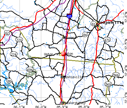
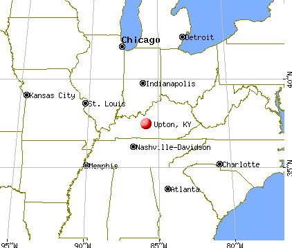
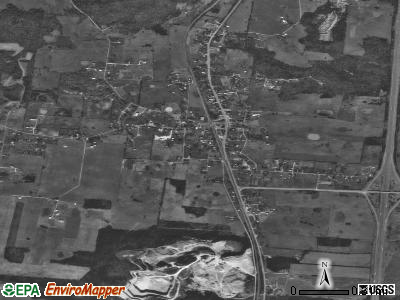
Upton, Kentucky
Submit your own pictures of this city and show them to the world
- OSM Map
- General Map
- Google Map
- MSN Map
Population change since 2000: +9.0%
 |
| Males: 347 | |
| Females: 366 |
| Median resident age: | 41.6 years |
| Kentucky median age: | 39.4 years |
Zip codes: 42784.
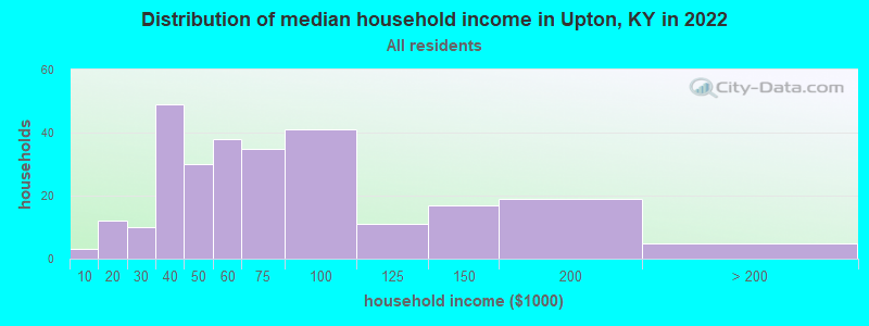
| Upton: | $57,348 |
| KY: | $59,341 |
Estimated per capita income in 2022: $31,565 (it was $13,886 in 2000)
Upton city income, earnings, and wages data
Estimated median house or condo value in 2022: $135,442 (it was $57,700 in 2000)
| Upton: | $135,442 |
| KY: | $196,300 |
Mean prices in 2022: all housing units: $132,330; detached houses: $142,656; mobile homes: $34,105
Median gross rent in 2022: $747.
(4.3% for White Non-Hispanic residents, 33.3% for American Indian residents, 4.8% for two or more races residents)
Detailed information about poverty and poor residents in Upton, KY
Compare current foreclosures near Upton, KY:
| Photo | Address | Area | Beds / Baths | Price | Details |
|---|---|---|---|---|---|

|
#1
Crissy St
Upton, KY 42784
|
1,490 sq. feet
|
2 baths 3 beds |
show details | |

|
#2
Jones St
Upton, KY 42784
|
1,232 sq. feet
|
1 baths 3 beds |
show details | |

|
#3
Lone Star Rd
Upton, KY 42784
|
1,792 sq. feet
|
2 baths 3 beds |
show details | |

|
#4
Grayson St
Upton, KY 42784
|
1,125 sq. feet
|
1 baths 3 beds |
show details | |

|
#5
S Dixie Hwy
Upton, KY 42784
|
- sq. feet
|
- baths - beds |
show details | |

|
#6
Rich St
Upton, KY 42784
|
- sq. feet
|
- baths - beds |
show details | |

|
#7
Old Dixie Loop
Upton, KY 42784
|
- sq. feet
|
- baths - beds |
show details | |

|
#8
Flint Hill Rd
Sonora, KY 42776
|
1,498 sq. feet
|
3 baths 3 beds |
show details | |

|
#9
Wells Rd
Buffalo, KY 42716
|
1,008 sq. feet
|
1 baths 2 beds |
show details | |

|
#10
Rippling Creek Pl
Elizabethtown, KY 42701
|
2,719 sq. feet
|
3 baths 4 beds |
show details |
| Photo | Address | Area | Beds / Baths | Price | Details |
|---|---|---|---|---|---|

|
#11
Leafdale Rd
Hodgenville, KY 42748
|
1,176 sq. feet
|
1 baths 3 beds |
show details | |

|
#12
Locust Grove Rd
Elizabethtown, KY 42701
|
1,380 sq. feet
|
2 baths 3 beds |
show details | |

|
#13
Julia Ln
Munfordville, KY 42765
|
1,536 sq. feet
|
2 baths 4 beds |
show details | |

|
#14
E Rainbow Way
Elizabethtown, KY 42701
|
1,974 sq. feet
|
2 baths 3 beds |
show details | |

|
#15
Mount Tabor Rd
Buffalo, KY 42716
|
1,248 sq. feet
|
2 baths 3 beds |
show details | |

|
#16
Forestville Rd
Munfordville, KY 42765
|
840 sq. feet
|
1 baths 2 beds |
show details | |

|
#17
Hardyville Rd
Munfordville, KY 42765
|
1,217 sq. feet
|
1 baths 2 beds |
show details | |

|
#18
Red Mill Rd
Elizabethtown, KY 42701
|
1,107 sq. feet
|
1 baths 3 beds |
show details | |

|
#19
Elk St
Munfordville, KY 42765
|
1,084 sq. feet
|
1 baths 2 beds |
show details | |

|
#20
N Buckner Ave
Munfordville, KY 42765
|
1,352 sq. feet
|
1 baths 3 beds |
show details |
| Photo | Address | Area | Beds / Baths | Price | Details |
|---|---|---|---|---|---|

|
#21
Stoney Brook Dr
Elizabethtown, KY 42701
|
1,402 sq. feet
|
2 baths 3 beds |
show details | |

|
#22
Rodeo Dr
Cecilia, KY 42724
|
1,344 sq. feet
|
2 baths 3 beds |
show details | |

|
#23
Crossgate Rd
Elizabethtown, KY 42701
|
1,120 sq. feet
|
2 baths 3 beds |
show details | |

|
#24
Elk St
Munfordville, KY 42765
|
1,120 sq. feet
|
1 baths 3 beds |
show details | |

|
#25
Silks Ct
Elizabethtown, KY 42701
|
1,484 sq. feet
|
2 baths 3 beds |
show details | |

|
#26
Rodgers Way
Cecilia, KY 42724
|
1,486 sq. feet
|
2 baths 3 beds |
show details | |

|
#27
Rochelle Dr
Elizabethtown, KY 42701
|
1,344 sq. feet
|
2 baths 3 beds |
show details | |

|
#28
Sportsman Lake Rd
Elizabethtown, KY 42701
|
1,120 sq. feet
|
2 baths 3 beds |
show details | |

|
#29
Claudie Ave
Elizabethtown, KY 42701
|
1,650 sq. feet
|
1 baths 3 beds |
show details | |

|
#30
Hodgenville Rd
Elizabethtown, KY 42701
|
1,363 sq. feet
|
2 baths 3 beds |
show details |
| Photo | Address | Area | Beds / Baths | Price | Details |
|---|---|---|---|---|---|

|
#31
Fleming Dr
Elizabethtown, KY 42701
|
1,186 sq. feet
|
2 baths 3 beds |
show details | |

|
#32
Georgetown Rd
Elizabethtown, KY 42701
|
1,125 sq. feet
|
1 baths 3 beds |
show details | |

|
#33
Valley Creek Rd
Elizabethtown, KY 42701
|
1,168 sq. feet
|
1 baths 3 beds |
show details | |

|
#34
Park Ave
Elizabethtown, KY 42701
|
1,590 sq. feet
|
1 baths 3 beds |
show details | |

|
#35
N Mantle Ave
Elizabethtown, KY 42701
|
1,148 sq. feet
|
1 baths 2 beds |
show details | |

|
#36
Orchard Dr
Elizabethtown, KY 42701
|
1,176 sq. feet
|
1 baths 4 beds |
show details | |

|
#37
Junell St
Elizabethtown, KY 42701
|
1,160 sq. feet
|
1 baths 3 beds |
show details | |

|
#38
Yates Chapel Rd
Cecilia, KY 42724
|
2,108 sq. feet
|
3 baths 4 beds |
show details | |

|
#39
Sycamore St
Elizabethtown, KY 42701
|
780 sq. feet
|
1 baths 2 beds |
show details | |

|
#40
El Dorado Dr
Elizabethtown, KY 42701
|
2,740 sq. feet
|
2 baths 3 beds |
show details |
| Photo | Address | Area | Beds / Baths | Price | Details |
|---|---|---|---|---|---|

|
#41
Walnut Hill Rd
Elizabethtown, KY 42701
|
1,164 sq. feet
|
2 baths 3 beds |
show details | |

|
#42
Transylvania Way
Elizabethtown, KY 42701
|
1,376 sq. feet
|
2 baths 3 beds |
show details | |

|
#43
W Anjou Ct
Elizabethtown, KY 42701
|
4,610 sq. feet
|
4 baths 5 beds |
show details | |

|
#44
Helm St
Elizabethtown, KY 42701
|
2,687 sq. feet
|
2 baths 3 beds |
show details | |

|
#45
King Arthur Cir
Elizabethtown, KY 42701
|
1,448 sq. feet
|
1 baths 3 beds |
show details | |

|
#46
Asbury Cir E
Elizabethtown, KY 42701
|
1,200 sq. feet
|
1 baths 3 beds |
show details | |

|
#47
Hardinsburg Rd
Cecilia, KY 42724
|
2,400 sq. feet
|
2 baths 3 beds |
show details | |

|
#48
Peters Dr
Elizabethtown, KY 42701
|
1,484 sq. feet
|
2 baths 3 beds |
show details | |

|
#49
College View Dr
Elizabethtown, KY 42701
|
2,210 sq. feet
|
2 baths 3 beds |
show details | |

|
Check over 1 million property listings on Foreclosure.com!
|
browse all offers | |||


- 56793.9%White alone
- 152.5%Hispanic
- 101.7%Two or more races
- 50.8%American Indian alone
- 40.7%Other race alone

Races in Upton detailed stats: ancestries, foreign born residents, place of birth
According to our research of Kentucky and other state lists, there were 8 registered sex offenders living in Upton, Kentucky as of May 23, 2024.
The ratio of all residents to sex offenders in Upton is 108 to 1.
 Recent articles from our blog. Our writers, many of them Ph.D. graduates or candidates, create easy-to-read articles on a wide variety of topics.

 | Upton, Kentucky / Doe Valley / Elizabethtown (15 replies) |
| Planting roots at Fort Knox? (11 replies) |
| The next Kentucky sub-forum(s)? (14 replies) |
| Rural KY photo "sticky" (336 replies) |
| So you've built an upscale home in Butchertown and now you want the SLAUGHTERHOUSE to Move??? (36 replies) |
| Where would you move? (12 replies) |
Latest news from Upton, KY collected exclusively by city-data.com from local newspapers, TV, and radio stations
Ancestries: American (33.8%), English (21.5%), Irish (16.0%), German (10.5%), French (1.4%), Scottish (1.4%).
Current Local Time: EST time zone
Incorporated on 01/19/1865
Elevation: 744 feet
Land area: 1.55 square miles.
Population density: 461 people per square mile (low).
9 residents are foreign born
| This city: | 1.5% |
| Kentucky: | 4.1% |
Median real estate property taxes paid for housing units with mortgages in 2022: $1,168 (0.8%)
Median real estate property taxes paid for housing units with no mortgage in 2022: $1,113 (0.9%)
Nearest city with pop. 50,000+: Louisville, KY  (53.6 miles , pop. 256,231).
Nearest city with pop. 1,000,000+: Chicago, IL (317.4 miles , pop. 2,896,016).
Nearest cities:
), ), ), ), )Latitude: 37.46 N, Longitude: 85.90 W
Area code commonly used in this area: 270

| Here: | 3.9% |
| Kentucky: | 3.8% |

- Construction (14.1%)
- Educational services (6.6%)
- Public administration (6.0%)
- Health care (6.0%)
- Repair & maintenance (5.7%)
- Plastics & rubber products (3.3%)
- Transportation equipment (3.3%)

- Construction (20.5%)
- Repair & maintenance (9.7%)
- Transportation equipment (5.6%)
- Plastics & rubber products (5.6%)
- Agriculture, forestry, fishing & hunting (4.1%)
- Administrative & support & waste management services (4.1%)
- Furniture & related product manufacturing (4.1%)

- Educational services (14.4%)
- Health care (10.1%)
- Public administration (8.6%)
- Apparel (5.8%)
- Construction (5.0%)
- Accommodation & food services (5.0%)
- Food & beverage stores (4.3%)

- Laborers and material movers, hand (6.9%)
- Other production occupations, including supervisors (5.1%)
- Building and grounds cleaning and maintenance occupations (4.8%)
- Metal workers and plastic workers (4.2%)
- Driver/sales workers and truck drivers (3.9%)
- Other office and administrative support workers, including supervisors (3.6%)
- Other sales and related occupations, including supervisors (3.6%)

- Laborers and material movers, hand (8.7%)
- Metal workers and plastic workers (7.2%)
- Driver/sales workers and truck drivers (6.7%)
- Building and grounds cleaning and maintenance occupations (6.7%)
- Other production occupations, including supervisors (5.6%)
- Vehicle and mobile equipment mechanics, installers, and repairers (5.6%)
- Electrical equipment mechanics and other installation, maintenance, and repair workers, including supervisors (4.1%)

- Other office and administrative support workers, including supervisors (8.6%)
- Information and record clerks, except customer service representatives (6.5%)
- Retail sales workers, except cashiers (5.0%)
- Waiters and waitresses (5.0%)
- Preschool, kindergarten, elementary, and middle school teachers (4.3%)
- Cashiers (4.3%)
- Textile, apparel, and furnishings workers (4.3%)
Average climate in Upton, Kentucky
Based on data reported by over 4,000 weather stations


(lower is better)

Air Quality Index (AQI) level in 2022 was 63.2. This is about average.
| City: | 63.2 |
| U.S.: | 72.6 |


Particulate Matter (PM2.5) [µg/m3] level in 2022 was 8.02. This is about average. Closest monitor was 17.0 miles away from the city center.
| City: | 8.02 |
| U.S.: | 8.11 |
Tornado activity:
Upton-area historical tornado activity is slightly above Kentucky state average. It is 50% greater than the overall U.S. average.
On 4/3/1974, a category F4 (max. wind speeds 207-260 mph) tornado 17.8 miles away from the Upton city center killed 3 people and injured 81 people and caused between $50,000 and $500,000 in damages.
On 4/3/1974, a category F5 (max. wind speeds 261-318 mph) tornado 39.4 miles away from the city center killed 31 people and injured 270 people and caused between $500,000 and $5,000,000 in damages.
Earthquake activity:
Upton-area historical earthquake activity is significantly above Kentucky state average. It is 137% greater than the overall U.S. average.On 4/18/2008 at 09:36:59, a magnitude 5.4 (5.1 MB, 4.8 MS, 5.4 MW, 5.2 MW, Class: Moderate, Intensity: VI - VII) earthquake occurred 128.3 miles away from Upton center
On 7/27/1980 at 18:52:21, a magnitude 5.2 (5.1 MB, 4.7 MS, 5.0 UK, 5.2 UK) earthquake occurred 118.4 miles away from Upton center
On 4/18/2008 at 09:36:59, a magnitude 5.2 (5.2 MW, Depth: 8.9 mi) earthquake occurred 128.3 miles away from Upton center
On 6/18/2002 at 17:37:15, a magnitude 5.0 (4.3 MB, 4.6 MW, 5.0 LG) earthquake occurred 109.3 miles away from Upton center
On 6/10/1987 at 23:48:54, a magnitude 5.1 (4.9 MB, 4.4 MS, 4.6 MS, 5.1 LG) earthquake occurred 143.3 miles away from Upton center
On 4/18/2008 at 15:14:16, a magnitude 4.8 (4.5 MB, 4.8 MW, 4.6 MW, Class: Light, Intensity: IV - V) earthquake occurred 127.4 miles away from Upton center
Magnitude types: regional Lg-wave magnitude (LG), body-wave magnitude (MB), surface-wave magnitude (MS), moment magnitude (MW)
Natural disasters:
The number of natural disasters in Hardin County (20) is greater than the US average (15).Major Disasters (Presidential) Declared: 16
Emergencies Declared: 2
Causes of natural disasters: Storms: 14, Floods: 13, Tornadoes: 9, Mudslides: 3, Winter Storms: 2, Blizzard: 1, Freeze: 1, Hurricane: 1, Landslide: 1, Snow: 1, Wind: 1, Other: 1 (Note: some incidents may be assigned to more than one category).

Colleges/universities with over 2000 students nearest to Upton:
- Elizabethtown Community and Technical College (about 17 miles; Elizabethtown, KY; Full-time enrollment: 3,762)
- Campbellsville University (about 32 miles; Campbellsville, KY; FT enrollment: 2,948)
- Lindsey Wilson College (about 42 miles; Columbia, KY; FT enrollment: 2,552)
- Western Kentucky University (about 46 miles; Bowling Green, KY; FT enrollment: 16,942)
- Southcentral Kentucky Community and Technical College (about 46 miles; Bowling Green, KY; FT enrollment: 2,794)
- University of Louisville (about 53 miles; Louisville, KY; FT enrollment: 16,640)
- Sullivan University (about 54 miles; Louisville, KY; FT enrollment: 5,129)
User-submitted facts and corrections:
- The Upton school has now closed. A new school in Sonora called Creek Side has taken it and Sonora Elm. place.
- Upton, KY includes two counties. It is in both Larue and Hardin county.
Points of interest:
Notable location: Upton Fire Department (A). Display/hide its location on the map
Cemetery: Big Springs Cemetery (1). Display/hide its location on the map
| This city: | 2.4 people |
| Kentucky: | 2.5 people |
| This city: | 65.8% |
| Whole state: | 66.9% |
| This city: | 8.5% |
| Whole state: | 6.4% |
Likely homosexual households (counted as self-reported same-sex unmarried-partner households)
- Lesbian couples: 0.7% of all households
- Gay men: 0.0% of all households
Banks with branches in Upton (2011 data):
- West Point Bank: Upton Branch at 114 North Walnut Street, branch established on 2008/03/24. Info updated 2006/11/03: Bank assets: $141.6 mil, Deposits: $77.7 mil, headquarters in Radcliff, KY, positive income, Mortgage Lending Specialization, 5 total offices, Holding Company: First Breckinridge Bancshares, Inc.
For population 15 years and over in Upton:

- Never married: 29.3%
- Now married: 56.8%
- Separated: 1.4%
- Widowed: 4.9%
- Divorced: 7.6%
For population 25 years and over in Upton:
- High school or higher: 85.2%
- Bachelor's degree or higher: 22.1%
- Graduate or professional degree: 2.1%
- Unemployed: 3.2%
- Mean travel time to work (commute): 28.1 minutes


| Here: | 10.0 |
| Kentucky average: | 11.7 |
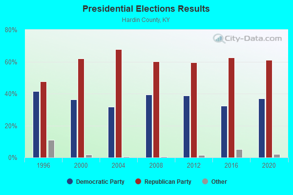
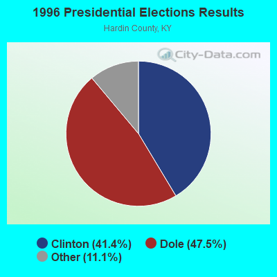
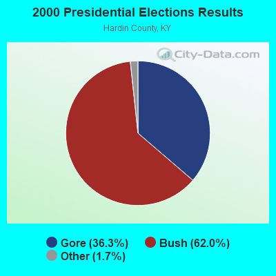

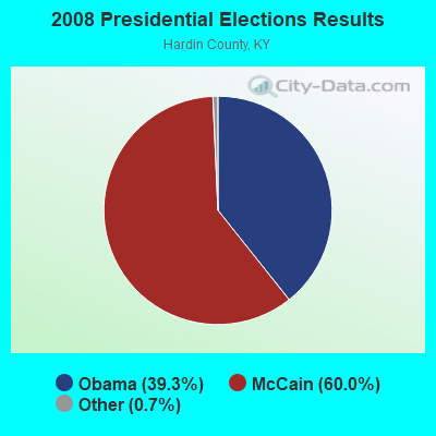
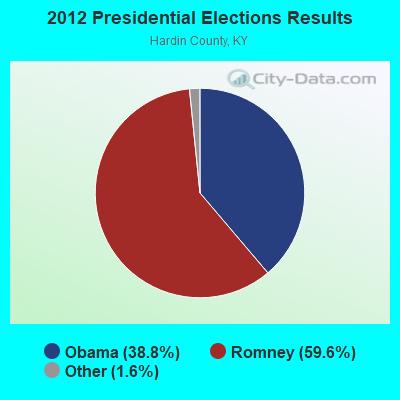
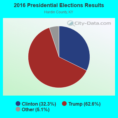

Graphs represent county-level data. Detailed 2008 Election Results
Religion statistics for Upton, KY (based on Hardin County data)
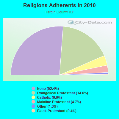

| Religion | Adherents | Congregations |
|---|---|---|
| Evangelical Protestant | 36,503 | 114 |
| Catholic | 6,986 | 6 |
| Mainline Protestant | 4,993 | 26 |
| Other | 1,363 | 4 |
| Black Protestant | 439 | 3 |
| None | 55,259 | - |
Food Environment Statistics:
| Hardin County: | 1.43 / 10,000 pop. |
| State: | 2.19 / 10,000 pop. |
| This county: | 0.20 / 10,000 pop. |
| Kentucky: | 0.25 / 10,000 pop. |
| Hardin County: | 0.51 / 10,000 pop. |
| Kentucky: | 0.74 / 10,000 pop. |
| This county: | 4.60 / 10,000 pop. |
| Kentucky: | 4.36 / 10,000 pop. |
| Here: | 5.82 / 10,000 pop. |
| Kentucky: | 5.74 / 10,000 pop. |
| This county: | 12.3% |
| Kentucky: | 11.0% |
| Here: | 30.3% |
| State: | 30.0% |
| Hardin County: | 13.6% |
| Kentucky: | 15.9% |
Health and Nutrition:
| Upton: | 51.5% |
| Kentucky: | 49.9% |
| This city: | 49.0% |
| Kentucky: | 47.0% |
| This city: | 28.6 |
| Kentucky: | 28.6 |
| Upton: | 20.8% |
| Kentucky: | 21.0% |
| This city: | 13.8% |
| Kentucky: | 10.1% |
| This city: | 6.8 |
| Kentucky: | 6.8 |
| Upton: | 40.2% |
| State: | 33.8% |
| Here: | 56.2% |
| Kentucky: | 56.8% |
| This city: | 82.2% |
| Kentucky: | 78.9% |
More about Health and Nutrition of Upton, KY Residents
Upton government finances - Expenditure in 2017 (per resident):
- Current Operations - Central Staff Services: $42,000 ($58.91)
Local Fire Protection: $30,000 ($42.08)
Parks and Recreation: $16,000 ($22.44)
Miscellaneous Commercial Activities - Other: $5,000 ($7.01)
Regular Highways: $1,000 ($1.40)
- General - Interest on Debt: $1,000 ($1.40)
- Other Capital Outlay - Regular Highways: $53,000 ($74.33)
Local Fire Protection: $16,000 ($22.44)
Parks and Recreation: $9,000 ($12.62)
- Total Salaries and Wages: $13,000 ($18.23)
Upton government finances - Revenue in 2017 (per resident):
- Local Intergovernmental - Other: $10,000 ($14.03)
- Miscellaneous - Special Assessments: $21,000 ($29.45)
Rents: $5,000 ($7.01)
Donations From Private Sources: $1,000 ($1.40)
- State Intergovernmental - Highways: $28,000 ($39.27)
Other: $19,000 ($26.65)
- Tax - Property: $70,000 ($98.18)
Public Utilities Sales: $21,000 ($29.45)
Upton government finances - Debt in 2017 (per resident):
- Long Term Debt - Beginning Outstanding - Unspecified Public Purpose: $36,000 ($50.49)
Outstanding Unspecified Public Purpose: $36,000 ($50.49)
Upton government finances - Cash and Securities in 2017 (per resident):
- Other Funds - Cash and Securities: $408,000 ($572.23)
8.88% of this county's 2021 resident taxpayers lived in other counties in 2020 ($51,737 average adjusted gross income)
| Here: | 8.88% |
| Kentucky average: | 7.04% |
0.25% of residents moved from foreign countries ($2,224 average AGI)
Hardin County: 0.25% Kentucky average: 0.02%
Top counties from which taxpayers relocated into this county between 2020 and 2021:
| from Jefferson County, KY | |
| from Meade County, KY | |
| from Larue County, KY |
8.87% of this county's 2020 resident taxpayers moved to other counties in 2021 ($50,666 average adjusted gross income)
| Here: | 8.87% |
| Kentucky average: | 6.89% |
0.15% of residents moved to foreign countries ($1,325 average AGI)
Hardin County: 0.15% Kentucky average: 0.01%
Top counties to which taxpayers relocated from this county between 2020 and 2021:
| to Jefferson County, KY | |
| to Meade County, KY | |
| to Larue County, KY |
Businesses in Upton, KY
- UPS: 1
Strongest AM radio stations in Upton:
- WHAS (840 AM; 50 kW; LOUISVILLE, KY; Owner: CLEAR CHANNEL BROADCASTING LICENSES, INC.)
- WXAM (1430 AM; 1 kW; BUFFALO, KY; Owner: MARK GOODMAN PRODUCTIONS, INC.)
- WSM (650 AM; 50 kW; NASHVILLE, TN; Owner: GAYLORD ENTERTAINMENT COMPANY)
- WLOC (1150 AM; 1 kW; MUNFORDVILLE, KY; Owner: HART COUNTY COMMUNICATIONS, INC.)
- WAMB (1160 AM; 50 kW; DONELSON, TN; Owner: GREAT SOUTHERN BROADCASTING COMPANY, INC.)
- WKDA (1200 AM; 50 kW; NASHVILLE, TN; Owner: RADIO NASHVILLE, INC.)
- WLAC (1510 AM; 50 kW; NASHVILLE, TN; Owner: CAPSTAR TX LIMITED PARTNERSHIP)
- WNQM (1300 AM; 50 kW; NASHVILLE, TN; Owner: WNQM. INC.)
- WIEL (1400 AM; 1 kW; ELIZABETHTOWN, KY; Owner: ELIZABETHTOWN CBC, INC.)
- WKCT (930 AM; 5 kW; BOWLING GREEN, KY; Owner: DAILY NEWS BROADCASTING CO.)
- WLW (700 AM; 50 kW; CINCINNATI, OH; Owner: JACOR BROADCASTING CORPORATION)
- WKVL (850 AM; daytime; 50 kW; KNOXVILLE, TN; Owner: HORNE RADIO, LLC)
- WKJK (1080 AM; 10 kW; LOUISVILLE, KY; Owner: CLEAR CHANNEL BROADCASTING LICENSES, INC.)
Strongest FM radio stations in Upton:
- WJCR-FM (90.1 FM; UPTON, KY; Owner: FM 90.1, INC.)
- WASE (103.5 FM; RADCLIFF, KY; Owner: W & B BROADCASTING, INC.)
- WKUE (90.9 FM; ELIZABETHTOWN, KY; Owner: WESTERN KENTUCKY UNIVERSITY)
- WQXE (98.3 FM; ELIZABETHTOWN, KY; Owner: SKYTOWER COMMUNICATIONS-E'TOWN, INC.)
- WKMO (106.3 FM; HODGENVILLE, KY; Owner: ELIZABETHTOWN CBC, INC.)
- WCLU-FM (102.3 FM; MUNFORDVILLE, KY; Owner: ROYSE RADIO, INC)
- WHHT (106.7 FM; HORSE CAVE, KY; Owner: NEWBERRY BROADCASTING, INC.)
- WLVK (105.5 FM; FORT KNOX, KY; Owner: BIG CAT BROADCASTING, INC.)
- WGGC (95.1 FM; GLASGOW, KY; Owner: HERITAGE COMMUNICATIONS, INC.)
- WKLX (100.7 FM; BROWNSVILLE, KY; Owner: CHARLES M. ANDERSON)
- WRZI (101.5 FM; VINE GROVE, KY; Owner: ELIZABETHTOWN CBC, INC.)
- WPTQ (103.7 FM; CAVE CITY, KY; Owner: NEWBERRY BROADCASTING, INC.)
- WTHX (107.3 FM; LEBANON JUNCTION, KY; Owner: ELIZABETHTOWN CBC, INC.)
- WGRK-FM (103.1 FM; GREENSBURG, KY; Owner: GREEN COUNTY CBC, INC.)
- WKHG (104.9 FM; LEITCHFIELD, KY; Owner: HERITAGE MEDIA OF KENTUCKY INC)
TV broadcast stations around Upton:
- WKZT-TV (Channel 23; ELIZABETHTOWN, KY; Owner: KENTUCKY AUTHORITY FOR EDUCATIONAL TV)
- WBKI-TV (Channel 34; CAMPBELLSVILLE, KY; Owner: LOUISVILLE COMMUNICATIONS, LLC)
- W39CJ (Channel 39; ELIZABETHTOWN, KY; Owner: TRINITY BROADCASTING NETWORK)
- WBKI-CA (Channel 28; LOUISVILLE, KY; Owner: LOUISVILLE COMMUNICATIONS, LLC)
Upton fatal accident list:
Mar 10, 1990 09:40 AM, 31w, Vehicles: 1, Persons: 3, Fatalities: 1
Dec 28, 1987 03:25 PM, 224, Vehicles: 1, Persons: 1, Fatalities: 1
- National Bridge Inventory (NBI) Statistics
- 2Number of bridges
- 26ft / 7.8mTotal length
- 40,593Total average daily traffic
- 14,178Total average daily truck traffic
FCC Registered Cell Phone Towers:
2 (See the full list of FCC Registered Cell Phone Towers in Upton)FCC Registered Antenna Towers:
29 (See the full list of FCC Registered Antenna Towers)FCC Registered Broadcast Land Mobile Towers:
3- E On Us 31 W (Lat: 37.472000 Lon: -85.894139), Call Sign: WNVA867,
Assigned Frequencies: 173.390 MHz, Grant Date: 03/29/1996, Expiration Date: 04/09/2001, Cancellation Date: 06/10/2001, Registrant: Hardin County Water District No 2, Elizabethtown, KY 42701, Phone: (502) 737-0156
- Peachtree St (Lat: 37.452833 Lon: -85.891639), Call Sign: WZN474, Licensee ID: L00087014,
Assigned Frequencies: 159.600 MHz, Grant Date: 08/14/2004, Expiration Date: 08/22/2014, Cancellation Date: 10/25/2014, Registrant: Cruse Trucking Inc, Upton, KY 42784, Phone: (502) 369-7670
- SHELTON RD PS, Shelton Rd Ps - 1005 Shelton Rd (Lat: 37.442583 Lon: -85.913944), Type: Pole, Structure height: 7.6 m, Call Sign: WQRV512,
Assigned Frequencies: 173.390 MHz, Grant Date: 05/04/2023, Expiration Date: 08/01/2033, Certifier: Shaun Youravich, Registrant: Micro-Comm, Inc., 15895 S. Pflumm Road, Olathe, KS 66062, Phone: (913) 390-4500, Fax: (913) 390-4550, Email:
FCC Registered Microwave Towers:
5- Upton, One Mile Northnorthwest Of (Lat: 37.448333 Lon: -85.880000), Type: Ltower, Structure height: 121.9 m, Overall height: 128 m, Call Sign: WQOB746,
Assigned Frequencies: 19425.0 MHz, 19425.0 MHz, 19425.0 MHz, 19425.0 MHz, 19425.0 MHz, 19425.0 MHz, 10795.0 MHz, Grant Date: 06/29/2021, Expiration Date: 08/04/2031, Cancellation Date: 10/23/2023, Certifier: Gregory M Romano, Registrant: Verizon Wireless, 5055 North Point Pkwy, Np2ne Network Engineering, Alpharetta, GA 30022, Phone: (770) 797-1070, Email:
- UPTON, 15385 South Dixie (Lat: 37.478611 Lon: -85.898833), Type: Gtower, Structure height: 91.7 m, Overall height: 99.1 m, Call Sign: WQSD239,
Assigned Frequencies: 10775.0 MHz, 10895.0 MHz, 10855.0 MHz, 11015.0 MHz, Grant Date: 08/16/2023, Expiration Date: 09/04/2033, Certifier: John E Monday, Registrant: At&t Services, Inc., 208 S Akard St, 20f, Dallas, TX 75202, Phone: (855) 699-7073, Email:
- LV03UB115, 15385 South Dixie Highway (Lat: 37.478611 Lon: -85.898833), Type: Gtower, Structure height: 91.7 m, Overall height: 99.1 m, Call Sign: WQST565,
Assigned Frequencies: 10815.0 MHz, 10815.0 MHz, 10815.0 MHz, 10815.0 MHz, 10815.0 MHz, 10815.0 MHz, Grant Date: 11/13/2013, Expiration Date: 11/13/2023, Cancellation Date: 05/13/2015, Certifier: Kyle B Entz, Registrant: Sprint Corporation, 12502 Sunrise Valley Drive, Reston, VA 20196, Phone: (703) 433-4000, Fax: (703) 433-4483
- 9LV0106F, 15385 South Dixie Highway (Lat: 37.478611 Lon: -85.898833), Type: Gtower, Structure height: 91.7 m, Overall height: 99.1 m, Call Sign: WQVH919,
Assigned Frequencies: 11095.0 MHz, 11095.0 MHz, 11095.0 MHz, 11095.0 MHz, 11095.0 MHz, 11095.0 MHz, 11095.0 MHz, 11095.0 MHz, 11055.0 MHz, 11055.0 MHz... (+19 more), Grant Date: 02/18/2015, Expiration Date: 02/18/2025, Certifier: David Werblow, Registrant: T-Mobile License LLC, 12920 Se 38th St, Bellevue, WA 98006, Phone: (425) 383-8401, Fax: (425) 383-4040, Email:
- STATION, Lone Star 5.5 Mi Sw Of (Lat: 37.401972 Lon: -85.953833), Overall height: 33.5 m, Call Sign: KPI40,
Assigned Frequencies: 6675.00 MHz, 6605.00 MHz, Grant Date: 07/08/1997, Expiration Date: 10/08/2002, Cancellation Date: 01/12/2003, Phone: (904) 359-1315
FCC Registered Amateur Radio Licenses:
7- Call Sign: KD4ABL, Licensee ID: L00338754, Grant Date: 04/30/2013, Expiration Date: 04/30/2023, Cancellation Date: 02/12/2016, Certifier: Patrick W Jenkins, Registrant: Patrick W Jenkins, 5158 Millerstown Rd, Upton, KY 42784
- Call Sign: KD4NYH, Grant Date: 05/05/1992, Expiration Date: 05/05/2002, Cancellation Date: 05/06/2004, Registrant: Tammy J Riddle, 139 N Walnut St, Upton, KY 42784
- Call Sign: KE4VQZ, Licensee ID: L01039420, Grant Date: 07/13/2005, Expiration Date: 07/13/2015, Cancellation Date: 07/14/2017, Registrant: David W Farmer, 176 Terry St, Upton, KY 42784-9462
- Call Sign: KI4UCU, Licensee ID: L01254010, Grant Date: 03/07/2007, Expiration Date: 03/07/2017, Cancellation Date: 03/08/2019, Certifier: Dale A Davisson, Registrant: Dale A Davisson, 248 High St, Upton, KY 42784
- Call Sign: KI4UID, Licensee ID: L01256749, Grant Date: 03/14/2007, Expiration Date: 03/14/2017, Cancellation Date: 03/15/2019, Certifier: Maryellen Davisson, Registrant: Maryellen Davisson, 248 High St, Upton, KY 42784
- Call Sign: KM4YXG, Licensee ID: L02063184, Grant Date: 11/14/2016, Expiration Date: 11/14/2026, Certifier: Joseph R Riggs, Registrant: Joseph R Riggs, 1910 Acre School Rd, Upton, KY 42784
- Call Sign: KO4VME, Licensee ID: L02510321, Grant Date: 12/17/2021, Expiration Date: 12/17/2031, Certifier: Mark R Bennett, Registrant: Mark R Bennett, 2603 Jenkins Rd, Upton, KY 42784
FAA Registered Aircraft:
1- Aircraft: CESSNA 182D (Category: Land, Seats: 4, Weight: Up to 12,499 Pounds, Speed: 119 mph), Engine: CONT MOTOR O-470 SERIES (230 HP) (Reciprocating)
N-Number: 1800Q, N1800Q, N-1800Q, Serial Number: 18253196, Year manufactured: 1961, Airworthiness Date: 01/13/1961, Certificate Issue Date: 09/14/2004
Registrant (Co-Owned): Richard A Niswander, 4553 Millerstown Rd, Upton, KY 42784, Other Owners: Lois N Niswander
2003 - 2018 National Fire Incident Reporting System (NFIRS) incidents
- Fire incident types reported to NFIRS in Upton, KY
- 8140.3%Structure Fires
- 7336.3%Outside Fires
- 3718.4%Mobile Property/Vehicle Fires
- 105.0%Other
 Based on the data from the years 2003 - 2018 the average number of fires per year is 13. The highest number of fires - 32 took place in 2008, and the least - 0 in 2006. The data has an increasing trend.
 When looking into fire subcategories, the most reports belonged to: Structure Fires (40.3%), and Outside Fires (36.3%).
| Most common first names in Upton, KY among deceased individuals | ||
| Name | Count | Lived (average) |
|---|---|---|
| William | 34 | 77.6 years |
| James | 24 | 74.4 years |
| Mary | 20 | 77.8 years |
| Charles | 14 | 73.1 years |
| John | 10 | 70.3 years |
| Joseph | 8 | 67.6 years |
| Ruth | 8 | 76.1 years |
| Harold | 8 | 61.4 years |
| Robert | 8 | 76.9 years |
| Willie | 7 | 75.6 years |
| Most common last names in Upton, KY among deceased individuals | ||
| Last name | Count | Lived (average) |
|---|---|---|
| Priddy | 47 | 75.6 years |
| Hornback | 30 | 77.8 years |
| Riggs | 27 | 80.1 years |
| Brackett | 17 | 77.5 years |
| Avery | 15 | 83.8 years |
| Smith | 14 | 71.6 years |
| Jenkins | 13 | 77.5 years |
| Fields | 12 | 75.4 years |
| Ward | 12 | 86.6 years |
| Cottrell | 11 | 78.5 years |

- 69.5%Electricity
- 24.1%Bottled, tank, or LP gas
- 5.3%Utility gas
- 1.1%Wood

- 81.9%Electricity
- 11.1%Bottled, tank, or LP gas
- 6.9%Wood
Upton compared to Kentucky state average:
- Unemployed percentage significantly below state average.
- Black race population percentage significantly below state average.
- Hispanic race population percentage below state average.
- Foreign-born population percentage significantly below state average.
- Length of stay since moving in significantly above state average.
- House age significantly above state average.
- Number of college students below state average.

|
Total of 2 patent applications in 2008-2024.