Upper Clover, Kentucky
Submit your own pictures of this place and show them to the world
- OSM Map
- General Map
- Google Map
- MSN Map

| Males: 923 | |
| Females: 919 |
| Median resident age: | 34.1 years |
| Kentucky median age: | 35.9 years |
Zip code: 40927
| Upper Clover: | $32,744 |
| KY: | $59,341 |
Estimated per capita income in 2022: $16,676 (it was $9,290 in 2000)
Upper Clover CCD income, earnings, and wages data
Estimated median house or condo value in 2022: $75,710 (it was $36,000 in 2000)
| Upper Clover: | $75,710 |
| KY: | $196,300 |
Mean prices in 2022: all housing units: $102,372; detached houses: $112,042; townhouses or other attached units: $117,777; in 2-unit structures: $250,926; mobile homes: $57,021
Detailed information about poverty and poor residents in Upper Clover, KY
Compare current foreclosures near Upper Clover, KY:
| Photo | Address | Area | Beds / Baths | Price | Details |
|---|---|---|---|---|---|

|
#1
Highway 522
Cumberland, KY 40823
|
2,000 sq. feet
|
1 baths 3 beds |
$120,000
|
show details |

|
#2
Sergent St
Evarts, KY 40828
|
1,008 sq. feet
|
1 baths 4 beds |
show details | |

|
#3
Green Street
Loyall, KY 40854
|
1,210 sq. feet
|
1 baths 2 beds |
show details | |

|
#4
E Mound St
Harlan, KY 40831
|
1,305 sq. feet
|
1 baths 3 beds |
show details | |

|
#5
Bedrock Dr
Dryden, VA 24243
|
1,597 sq. feet
|
2 baths 3 beds |
show details | |

|
#6
Big Fork Rd
Yeaddiss, KY 41777
|
768 sq. feet
|
1 baths 3 beds |
show details | |

|
#7
Hazelnut Dr
Yeaddiss, KY 41777
|
1,680 sq. feet
|
1 baths 4 beds |
show details | |

|
#8
Veterans Memorial Hwy
Big Stone Gap, VA 24219
|
- sq. feet
|
2 baths 3 beds |
show details | |

|
#9
Delvale Rd
Keokee, VA 24265
|
- sq. feet
|
1 baths 3 beds |
show details | |

|
#10
Hamner Hollow Rd
Big Stone Gap, VA 24219
|
- sq. feet
|
- baths - beds |
show details |
| Photo | Address | Area | Beds / Baths | Price | Details |
|---|---|---|---|---|---|

|
#11
Highway 160
Whitesburg, KY 41858
|
- sq. feet
|
- baths - beds |
show details | |

|
#12
Couch Dr
Cornettsville, KY 41731
|
- sq. feet
|
- baths - beds |
show details | |

|
#13
Cutshin Rd
Yeaddiss, KY 41777
|
- sq. feet
|
- baths - beds |
show details | |

|
#14
Gilbert St
Harlan, KY 40831
|
- sq. feet
|
- baths - beds |
show details | |

|
#15
Campbell Town Rd
Cornettsville, KY 41731
|
- sq. feet
|
- baths - beds |
show details | |

|
#16
Beatty Branch Rd
Wooton, KY 41776
|
720 sq. feet
|
- baths - beds |
show details | |

|
#17
Old Dixon Rd
Blackey, KY 41804
|
- sq. feet
|
- baths - beds |
show details | |

|
#18
Highway 1103
Hallie, KY 41821
|
- sq. feet
|
- baths - beds |
show details | |

|
#19
Bent Branch Rd
Cornettsville, KY 41731
|
- sq. feet
|
- baths - beds |
show details | |

|
#20
Chappell Dr
Baxter, KY 40806
|
- sq. feet
|
- baths - beds |
show details |
| Photo | Address | Area | Beds / Baths | Price | Details |
|---|---|---|---|---|---|

|
#21
Sycamore Rd
Appalachia, VA 24216
|
- sq. feet
|
- baths - beds |
show details | |

|
#22
Harlan Gas Rd
Harlan, KY 40831
|
- sq. feet
|
- baths - beds |
show details | |

|
#23
Seibers Rd
Closplint, KY 40927
|
- sq. feet
|
- baths - beds |
show details | |

|
#24
Highway 522
Totz, KY 40870
|
- sq. feet
|
- baths - beds |
show details | |

|
#25
Highway 160
Linefork, KY 41833
|
- sq. feet
|
- baths - beds |
show details | |

|
#26
Shavers Ford Rd
Jonesville, VA 24263
|
- sq. feet
|
- baths - beds |
show details | |

|
#27
Cutshin Rd
Wooton, KY 41776
|
- sq. feet
|
- baths - beds |
show details | |

|
#28
Plant Rd
Cawood, KY 40815
|
- sq. feet
|
- baths - beds |
show details | |

|
#29
Highway 3403
Partridge, KY 40862
|
- sq. feet
|
- baths - beds |
show details | |

|
#30
Day Ln
Cawood, KY 40815
|
- sq. feet
|
- baths - beds |
show details |
| Photo | Address | Area | Beds / Baths | Price | Details |
|---|---|---|---|---|---|

|
#31
Spruce St
Benham, KY 40807
|
- sq. feet
|
- baths - beds |
show details | |

|
#32
Highway 215
Evarts, KY 40828
|
- sq. feet
|
- baths - beds |
show details | |

|
#33
Stonegate Dr Apt 335
Pennington Gap, VA 24277
|
- sq. feet
|
- baths - beds |
show details | |

|
#34
Ky Highway 463
Delphia, KY 41735
|
- sq. feet
|
- baths - beds |
show details | |

|
#35
E Highway 221
Bledsoe, KY 40810
|
- sq. feet
|
- baths - beds |
show details | |

|
#36
Red Bud Hill Rd
Evarts, KY 40828
|
- sq. feet
|
- baths - beds |
show details | |

|
#37
Railroad St
Cumberland, KY 40823
|
- sq. feet
|
- baths - beds |
show details | |

|
#38
Woodland Ln
Cumberland, KY 40823
|
- sq. feet
|
- baths - beds |
show details | |

|
#39
Highway 522
Baxter, KY 40806
|
- sq. feet
|
- baths - beds |
show details | |

|
#40
Pleasant Dr
Harlan, KY 40831
|
- sq. feet
|
- baths - beds |
show details |
| Photo | Address | Area | Beds / Baths | Price | Details |
|---|---|---|---|---|---|

|
#41
Derby Rd
Appalachia, VA 24216
|
- sq. feet
|
- baths - beds |
show details | |

|
#42
Big Hill Rd
Pennington Gap, VA 24277
|
- sq. feet
|
- baths - beds |
show details | |

|
#43
Callahan Ave
Appalachia, VA 24216
|
- sq. feet
|
- baths - beds |
show details | |

|
#44
Elk Knob Rd
Pennington Gap, VA 24277
|
- sq. feet
|
- baths - beds |
show details | |

|
#45
Poplar Ter
Harlan, KY 40831
|
- sq. feet
|
- baths - beds |
show details | |

|
#46
Ivy Hl
Harlan, KY 40831
|
- sq. feet
|
- baths - beds |
show details | |

|
#47
E 23rd St S
Big Stone Gap, VA 24219
|
- sq. feet
|
- baths - beds |
show details | |

|
Check over 1 million property listings on Foreclosure.com!
|
browse all offers | |||

- 1,91798.0%White alone
- 130.7%Black alone
- 130.7%Two or more races
- 70.4%Hispanic
- 40.2%Other race alone
- 20.1%American Indian alone
- 10.05%Asian alone

Races in Upper Clover detailed stats: ancestries, foreign born residents, place of birth
 Recent articles from our blog. Our writers, many of them Ph.D. graduates or candidates, create easy-to-read articles on a wide variety of topics.
Current Local Time: EST time zone
Land area: 60.6 square miles.
Population density: 30 people per square mile (very low).

| Upper Clover CCD: | 0.7% ($256) |
| Kentucky: | 0.8% ($610) |
Nearest city with pop. 50,000+: Johnson City, TN  (54.0 miles , pop. 55,469).
Nearest city with pop. 200,000+: Fayette, KY (111.5 miles , pop. 260,512).
Nearest city with pop. 1,000,000+: Chicago, IL (422.1 miles , pop. 2,896,016).
Nearest cities:
), ), ), Latitude: 36.89 N, Longitude: 83.06 W
Area code commonly used in this area: 606


| Here: | 5.9% |
| Kentucky: | 3.8% |

- Mining, quarrying, oil & gas extraction (22.9%)
- Educational services (16.1%)
- Food & beverage stores (7.0%)
- Construction (6.3%)
- Accommodation & food services (5.5%)
- U. S. Postal service (3.9%)
- Health care (3.9%)

- Mining, quarrying, oil & gas extraction (47.3%)
- Construction (12.9%)
- Food & beverage stores (9.5%)
- Agriculture, forestry, fishing & hunting (7.0%)
- Metal & metal products (4.0%)
- Administrative & support & waste management services (4.0%)
- Used merchandise, gift, novelty, souvenir, other miscellaneous stores (3.5%)

- Educational services (29.4%)
- Accommodation & food services (8.4%)
- U. S. Postal service (7.5%)
- Health care (7.5%)
- Department & other general merchandise stores (7.0%)
- Finance & insurance (5.6%)
- Other transportation, support activities, couriers (5.1%)

- Extraction workers (10.1%)
- Cooks and food preparation workers (7.7%)
- Other sales and related occupations, including supervisors (5.8%)
- Preschool, kindergarten, elementary, and middle school teachers (5.1%)
- Electrical equipment mechanics and other installation, maintenance, and repair workers, including supervisors (4.1%)
- Building and grounds cleaning and maintenance occupations (3.6%)
- Supervisors and other personal care and service workers, except child care workers (3.4%)

- Extraction workers (20.9%)
- Electrical equipment mechanics and other installation, maintenance, and repair workers, including supervisors (8.5%)
- Driver/sales workers and truck drivers (6.0%)
- Other material moving workers, except laborers (5.5%)
- Carpenters (5.0%)
- Other protective service workers, including supervisors (4.5%)
- Fishing, hunting, and forestry occupations (4.5%)

- Cooks and food preparation workers (12.6%)
- Preschool, kindergarten, elementary, and middle school teachers (9.8%)
- Other sales and related occupations, including supervisors (8.4%)
- Cashiers (5.6%)
- Building and grounds cleaning and maintenance occupations (5.1%)
- Bus drivers (5.1%)
- Secretaries and administrative assistants (4.7%)
Average climate in Upper Clover, Kentucky
Based on data reported by over 4,000 weather stations


Tornado activity:
Upper Clover-area historical tornado activity is significantly below Kentucky state average. It is 67% smaller than the overall U.S. average.
On 5/9/1988, a category F3 (max. wind speeds 158-206 mph) tornado 38.4 miles away from the Upper Clover place center killed one person and injured 15 people and caused between $5,000,000 and $50,000,000 in damages.
On 7/6/1980, a category F2 (max. wind speeds 113-157 mph) tornado 23.9 miles away from the place center caused between $50,000 and $500,000 in damages.
Earthquake activity:
Upper Clover-area historical earthquake activity is significantly above Kentucky state average. It is 42% greater than the overall U.S. average.On 7/27/1980 at 18:52:21, a magnitude 5.2 (5.1 MB, 4.7 MS, 5.0 UK, 5.2 UK, Class: Moderate, Intensity: VI - VII) earthquake occurred 103.1 miles away from the city center
On 8/9/2020 at 12:07:37, a magnitude 5.1 (5.1 MW, Depth: 4.7 mi) earthquake occurred 112.7 miles away from the city center
On 8/23/2011 at 17:51:04, a magnitude 5.8 (5.8 MW, Depth: 3.7 mi) earthquake occurred 290.1 miles away from Upper Clover center
On 11/30/1973 at 07:48:41, a magnitude 4.7 (4.7 MB, 4.6 ML, Class: Light, Intensity: IV - V) earthquake occurred 90.7 miles away from the city center
On 9/7/1988 at 02:28:09, a magnitude 4.6 (4.5 MB, 4.6 LG) earthquake occurred 97.6 miles away from the city center
On 11/10/2012 at 17:08:14, a magnitude 4.2 (4.2 MW, Depth: 10.6 mi) earthquake occurred 17.2 miles away from the city center
Magnitude types: regional Lg-wave magnitude (LG), body-wave magnitude (MB), local magnitude (ML), surface-wave magnitude (MS), moment magnitude (MW)
Natural disasters:
The number of natural disasters in Harlan County (21) is greater than the US average (15).Major Disasters (Presidential) Declared: 14
Emergencies Declared: 2
Causes of natural disasters: Floods: 14, Storms: 11, Mudslides: 6, Landslides: 5, Tornadoes: 4, Winter Storms: 3, Fires: 2, Snows: 2, Snowstorms: 2, Winds: 2, Blizzard: 1, Freeze: 1, Hurricane: 1, Snowfall: 1, Other: 1 (Note: some incidents may be assigned to more than one category).
Colleges/universities with over 2000 students nearest to Upper Clover:
- Southeast Kentucky Community and Technical College (about 7 miles; Cumberland, KY; Full-time enrollment: 2,196)
- Hazard Community and Technical College (about 25 miles; Hazard, KY; FT enrollment: 2,087)
- Lincoln Memorial University (about 40 miles; Harrogate, TN; FT enrollment: 3,706)
- Northeast State Community College (about 46 miles; Blountville, TN; FT enrollment: 4,480)
- Walters State Community College (about 49 miles; Morristown, TN; FT enrollment: 4,359)
- Tusculum College (about 53 miles; Greeneville, TN; FT enrollment: 2,070)
- King University (about 55 miles; Bristol, TN; FT enrollment: 2,472)
Points of interest:
Notable locations in Upper Clover: Kettle Rockhouse (A), Upper Cloverfork Fire Department (B), Harlan County Rural Fire Department Station 2 (C). Display/hide their locations on the map
Churches in Upper Clover include: Mill Branch Church (A), Huff Church (B). Display/hide their locations on the map
Cemeteries: Kelly Cemetery (1), Robbins Cemetery (2), Adams Cemetery (3). Display/hide their locations on the map
Streams, rivers, and creeks: Deep Gap Branch (A), Childs Branch (B), Days Creek (C), Dry Branch (D), Fanny Wynn Branch (E), Upper Trace Branch (F), Fugitt Creek (G), Jacks Fork (H), Jerry Fork (I). Display/hide their locations on the map
| This place: | 2.7 people |
| Kentucky: | 2.5 people |
| This place: | 63.9% |
| Whole state: | 69.8% |
| This place: | 4.3% |
| Whole state: | 4.5% |
Likely homosexual households (counted as self-reported same-sex unmarried-partner households)
- Lesbian couples: 0.4% of all households
- Gay men: 0.4% of all households
| This place: | 35.3% |
| Whole state: | 15.8% |
| This place: | 14.3% |
| Whole state: | 6.6% |
For population 15 years and over in Upper Clover:

- Never married: 23.2%
- Now married: 61.6%
- Separated: 0.7%
- Widowed: 8.2%
- Divorced: 6.9%
For population 25 years and over in Upper Clover:
- High school or higher: 49.3%
- Bachelor's degree or higher: 3.9%
- Graduate or professional degree: 1.5%
- Unemployed: 15.8%
- Mean travel time to work (commute): 26.7 minutes


| Here: | 19.0 |
| Kentucky average: | 13.8 |
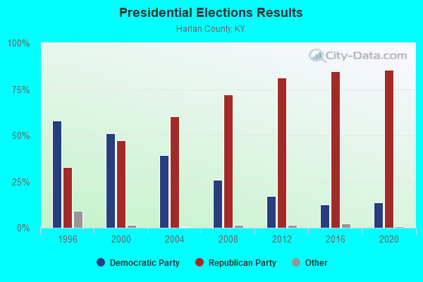
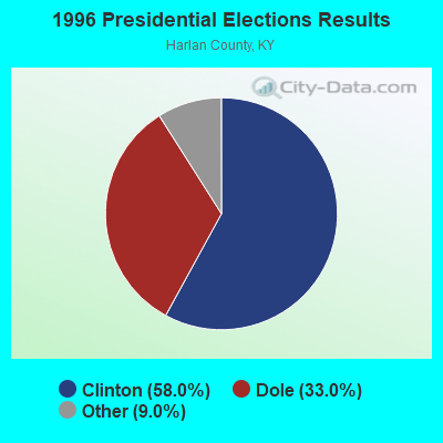
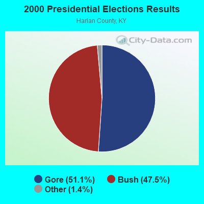
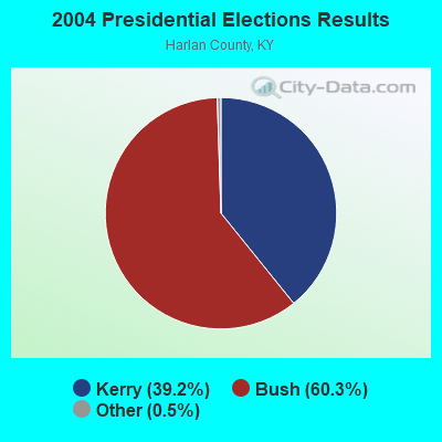
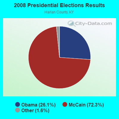
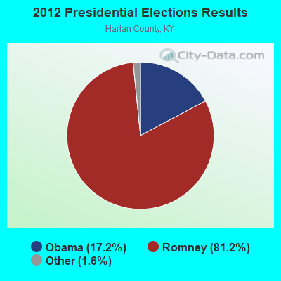

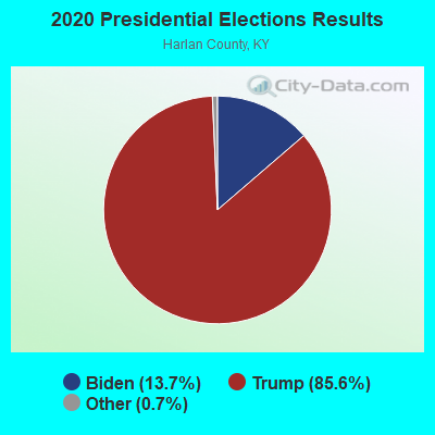
Graphs represent county-level data. Detailed 2008 Election Results
Religion statistics for Upper Clover, KY (based on Harlan County data)
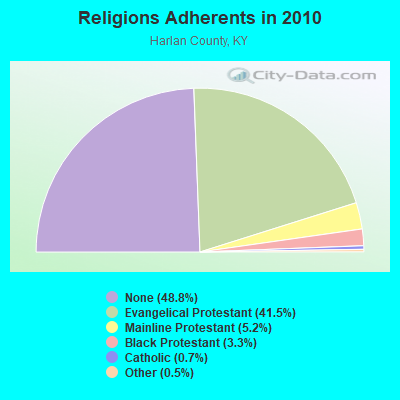
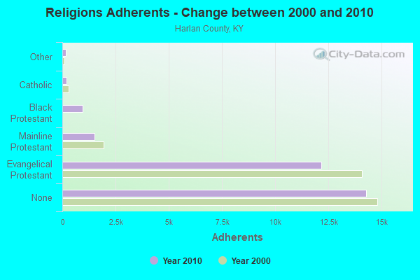
| Religion | Adherents | Congregations |
|---|---|---|
| Evangelical Protestant | 12,152 | 95 |
| Mainline Protestant | 1,524 | 13 |
| Black Protestant | 968 | 3 |
| Catholic | 207 | 3 |
| Other | 151 | 2 |
| None | 14,276 | - |
Food Environment Statistics:
| Harlan County: | 3.22 / 10,000 pop. |
| Kentucky: | 2.19 / 10,000 pop. |
| Here: | 0.64 / 10,000 pop. |
| Kentucky: | 0.74 / 10,000 pop. |
| Harlan County: | 4.18 / 10,000 pop. |
| Kentucky: | 4.36 / 10,000 pop. |
| This county: | 2.57 / 10,000 pop. |
| Kentucky: | 5.74 / 10,000 pop. |
| Harlan County: | 12.9% |
| State: | 11.0% |
| This county: | 29.8% |
| Kentucky: | 30.0% |
| Harlan County: | 21.0% |
| Kentucky: | 15.9% |
Strongest AM radio stations in Upper Clover:
- WFSR (970 AM; 5 kW; HARLAN, KY; Owner: EASTERN BROADCASTING COMPAY)
- WSWV (1570 AM; 2 kW; PENNINGTON GAP, VA; Owner: IBS COMMUNICATIONS, L.L.C.)
- WCPM (1280 AM; 1 kW; CUMBERLAND, KY; Owner: CUMBERLAND CITY BROADCASTING, INC.)
- WHLN (1410 AM; 5 kW; HARLAN, KY)
- WKVL (850 AM; daytime; 50 kW; KNOXVILLE, TN; Owner: HORNE RADIO, LLC)
- WTCW (920 AM; 4 kW; WHITESBURG, KY; Owner: T.C.W. BROADCASTING , INC.)
- WGOC (640 AM; 10 kW; BLOUNTVILLE, TN; Owner: CITADEL BROADCASTING COMPANY)
- WPWT (870 AM; daytime; 10 kW; COLONIAL HEIGHTS, TN; Owner: INFORMATION COMMUNICATIONS CORP.)
- WKIC (1390 AM; 5 kW; HAZARD, KY)
- WNVA (1350 AM; 5 kW; NORTON, VA; Owner: RADIO-WISE, INC.)
- WFGW (1010 AM; 50 kW; BLACK MOUNTAIN, NC; Owner: BLUE RIDGE BROADCASTING CORP.)
- WZAP (690 AM; 10 kW; BRISTOL, VA; Owner: RAM COMMUNICATIONS, INC.)
- WHGG (1090 AM; daytime; 10 kW; KINGSPORT, TN; Owner: APPALACHIAN EDUCATIONAL COMMUNICATIO)
Strongest FM radio stations in Upper Clover:
- WSEH (102.7 FM; CUMBERLAND, KY; Owner: CUMBERLAND CITY BROADCASTING, INC.)
- WAXM (93.5 FM; BIG STONE GAP, VA; Owner: VALLEY BROADCASTING, INC.)
- WTUK (105.1 FM; HARLAN, KY; Owner: EASTERN BROADCASTING COMPANY)
- W223AA (92.5 FM; BIG STONE GAP, VA; Owner: VALLEY BROADCASTING, INC.)
- WSGS (101.1 FM; HAZARD, KY; Owner: MOUNTAIN BROADCASTING SERVICE, INC.)
- WIFX-FM (94.3 FM; JENKINS, KY; Owner: LETCHER COUNTY BROADCASTING, INC)
- WXKQ-FM (103.9 FM; WHITESBURG, KY; Owner: T.C.W. BROADCASTING , INC.)
- WMMT (88.7 FM; WHITESBURG, KY; Owner: APPALSHOP, INCORPORATED)
- WTFM (98.5 FM; KINGSPORT, TN; Owner: HOLSTON VALLEY BROADCASTING CORP.)
- WEKH (90.9 FM; HAZARD, KY; Owner: EASTERN KENTUCKY UNIVERSITY)
- WZQQ (97.9 FM; HYDEN, KY; Owner: LESLIE COUNTY BROADCASTING, INC.)
- WJMD (104.7 FM; HAZARD, KY; Owner: HAZARD BROADCASTING SERVICES)
- WDXC (102.3 FM; POUND, VA; Owner: WDXC RADIO, INC.)
- WJDT (106.5 FM; ROGERSVILLE, TN; Owner: C & S BROADCASTING)
- WSWV-FM (105.5 FM; PENNINGTON GAP, VA; Owner: IBS COMMUNICATIONS, L.L.C.)
- WJNV (99.1 FM; JONESVILLE, VA; Owner: REGINA KAY MOORE)
- WRZK (95.9 FM; COLONIAL HEIGHTS, TN; Owner: MURRAY COMMUNICATIONS)
- WBGQ (100.7 FM; BULLS GAP, TN; Owner: CHEROKEE BROADCASTING)
- WHCB (91.5 FM; BRISTOL, TN; Owner: APPALACHIAN EDUC. COMMUNICATION CORP)
- WETS-FM (89.5 FM; JOHNSON CITY, TN; Owner: EAST TENNESSEE STATE UNIVERSITY)
TV broadcast stations around Upper Clover:
- W24BT (Channel 24; TALBERT, KY; Owner: MS COMMUNICATIONS, LLC)
- WYMT-TV (Channel 57; HAZARD, KY; Owner: WYMT LICENSEE CORP.)
- W31BU (Channel 31; TALBERT, KY; Owner: MS COMMUNICATIONS, LLC)
- W53BQ (Channel 53; TALBERT, KY; Owner: MS COMMUNICATIONS, LLC)
- W69ED (Channel 69; TALBERT, KY; Owner: MS COMMUNICATIONS, LLC)
- WAGV (Channel 44; HARLAN, KY; Owner: LIVING FAITH MINISTRIES, INC.)
- WKHA (Channel 35; HAZARD, KY; Owner: KENTUCKY AUTHORITY FOR EDUCATIONAL TV)
- W26BK (Channel 26; TALBERT, KY; Owner: MS COMMUNICATIONS, LLC)
- WAPM-CA (Channel 9; LYNCH/BENHAM, KY; Owner: HOLSTON VALLEY BROADCASTING CORPORATION)

- 74.0%Electricity
- 19.7%Coal or coke
- 4.9%Fuel oil, kerosene, etc.
- 1.4%Bottled, tank, or LP gas

- 67.2%Electricity
- 10.9%Bottled, tank, or LP gas
- 10.9%Fuel oil, kerosene, etc.
- 10.9%Coal or coke
Upper Clover compared to Kentucky state average:
- Median household income below state average.
- Median house value significantly below state average.
- Black race population percentage significantly below state average.
- Hispanic race population percentage significantly below state average.
- Median age below state average.
- Foreign-born population percentage significantly below state average.
- Renting percentage significantly below state average.
- Length of stay since moving in significantly above state average.
- Number of rooms per house significantly below state average.
- House age significantly below state average.
- Number of college students below state average.
- Percentage of population with a bachelor's degree or higher significantly below state average.