Turnerville, Georgia
Submit your own pictures of this place and show them to the world
- OSM Map
- General Map
- Google Map
- MSN Map

| Males: 1,859 | |
| Females: 1,850 |
| Median resident age: | 40.0 years |
| Georgia median age: | 33.4 years |
Zip code: 30523
| Turnerville: | $67,245 |
| GA: | $72,837 |
Estimated per capita income in 2022: $31,022 (it was $18,629 in 2000)
Turnerville CCD income, earnings, and wages data
Estimated median house or condo value in 2022: $229,355 (it was $90,500 in 2000)
| Turnerville: | $229,355 |
| GA: | $297,400 |
Mean prices in 2022: all housing units: $265,252; detached houses: $293,678; townhouses or other attached units: $252,727; mobile homes: $109,153
Detailed information about poverty and poor residents in Turnerville, GA


- 3,03095.3%White alone
- 682.1%Hispanic
- 311.0%Two or more races
- 190.6%Black alone
- 170.5%American Indian alone
- 120.4%Asian alone
- 10.03%Other race alone

Races in Turnerville detailed stats: ancestries, foreign born residents, place of birth
 Recent articles from our blog. Our writers, many of them Ph.D. graduates or candidates, create easy-to-read articles on a wide variety of topics.
Current Local Time: EST time zone
Elevation: 1570 feet
Land area: 56.0 square miles.
Population density: 66 people per square mile (very low).

| Turnerville CCD: | 0.7% ($616) |
| Georgia: | 0.9% ($919) |
Nearest city with pop. 50,000+: Athens-Clarke County, GA  (49.7 miles , pop. 100,266).
Nearest city with pop. 200,000+: Atlanta, GA (84.1 miles , pop. 416,474).
Nearest city with pop. 1,000,000+: Chicago, IL (546.6 miles , pop. 2,896,016).
Nearest cities:
Latitude: 34.67 N, Longitude: 83.43 W
Area code commonly used in this area: 706


| Here: | 3.1% |
| Georgia: | 2.9% |

- Construction (12.1%)
- Health care (9.1%)
- Educational services (8.0%)
- Finance & insurance (6.4%)
- Metal & metal products (6.4%)
- Textile mills & textile products (6.2%)
- Accommodation & food services (6.2%)

- Construction (19.5%)
- Accommodation & food services (7.2%)
- Agriculture, forestry, fishing & hunting (6.2%)
- Metal & metal products (6.0%)
- Textile mills & textile products (5.8%)
- Finance & insurance (5.4%)
- Public administration (5.2%)

- Health care (20.3%)
- Educational services (12.9%)
- Finance & insurance (7.9%)
- Metal & metal products (6.9%)
- Textile mills & textile products (6.8%)
- Accommodation & food services (4.7%)
- Apparel (4.3%)

- Other management occupations, except farmers and farm managers (6.6%)
- Other production occupations, including supervisors (5.4%)
- Other sales and related occupations, including supervisors (4.7%)
- Electrical equipment mechanics and other installation, maintenance, and repair workers, including supervisors (4.1%)
- Textile, apparel, and furnishings workers (3.6%)
- Carpenters (3.4%)
- Other office and administrative support workers, including supervisors (3.1%)

- Other management occupations, except farmers and farm managers (7.6%)
- Electrical equipment mechanics and other installation, maintenance, and repair workers, including supervisors (7.1%)
- Other sales and related occupations, including supervisors (6.0%)
- Carpenters (5.4%)
- Other production occupations, including supervisors (5.4%)
- Construction laborers (4.5%)
- Metal workers and plastic workers (3.7%)

- Secretaries and administrative assistants (6.6%)
- Other office and administrative support workers, including supervisors (6.3%)
- Textile, apparel, and furnishings workers (5.8%)
- Other production occupations, including supervisors (5.5%)
- Other management occupations, except farmers and farm managers (5.4%)
- Preschool, kindergarten, elementary, and middle school teachers (5.0%)
- Registered nurses (3.6%)
Average climate in Turnerville, Georgia
Based on data reported by over 4,000 weather stations


(lower is better)

Air Quality Index (AQI) level in 2019 was 50.7. This is significantly better than average.
| City: | 50.7 |
| U.S.: | 72.6 |

Sulfur Dioxide (SO2) [ppb] level in 2019 was 0.0756. This is significantly better than average. Closest monitor was 14.3 miles away from the city center.
| City: | 0.0756 |
| U.S.: | 1.5147 |

Ozone [ppb] level in 2018 was 36.8. This is about average. Closest monitor was 14.3 miles away from the city center.
| City: | 36.8 |
| U.S.: | 33.3 |

Particulate Matter (PM2.5) [µg/m3] level in 2019 was 6.17. This is better than average. Closest monitor was 14.3 miles away from the city center.
| City: | 6.17 |
| U.S.: | 8.11 |
Tornado activity:
Turnerville-area historical tornado activity is near Georgia state average. It is 18% greater than the overall U.S. average.
On 3/27/1994, a category F3 (max. wind speeds 158-206 mph) tornado 2.0 miles away from the Turnerville place center injured 37 people and caused between $500,000 and $5,000,000 in damages.
On 3/27/1994, a category F3 tornado 3.9 miles away from the place center killed 3 people and injured 45 people and caused between $5,000,000 and $50,000,000 in damages.
Earthquake activity:
Turnerville-area historical earthquake activity is significantly above Georgia state average. It is 43% greater than the overall U.S. average.On 8/2/1974 at 08:52:09, a magnitude 4.9 (4.3 MB, 4.9 LG, Class: Light, Intensity: IV - V) earthquake occurred 77.3 miles away from Turnerville center
On 11/30/1973 at 07:48:41, a magnitude 4.7 (4.7 MB, 4.6 ML) earthquake occurred 83.5 miles away from Turnerville center
On 4/29/2003 at 08:59:39, a magnitude 4.9 (4.4 MB, 4.6 MW, 4.9 LG) earthquake occurred 125.8 miles away from the city center
On 8/9/2020 at 12:07:37, a magnitude 5.1 (5.1 MW, Depth: 4.7 mi, Class: Moderate, Intensity: VI - VII) earthquake occurred 181.2 miles away from Turnerville center
On 4/29/2003 at 08:59:39, a magnitude 4.6 (4.6 MW, Depth: 12.3 mi) earthquake occurred 125.8 miles away from the city center
On 7/27/1980 at 18:52:21, a magnitude 5.2 (5.1 MB, 4.7 MS, 5.0 UK, 5.2 UK) earthquake occurred 246.0 miles away from the city center
Magnitude types: regional Lg-wave magnitude (LG), body-wave magnitude (MB), local magnitude (ML), surface-wave magnitude (MS), moment magnitude (MW)
Natural disasters:
The number of natural disasters in Habersham County (14) is near the US average (15).Major Disasters (Presidential) Declared: 9
Emergencies Declared: 4
Causes of natural disasters: Winter Storms: 5, Floods: 4, Storms: 4, Hurricanes: 3, Tornadoes: 3, Drought: 1, Snowfall: 1, Wind: 1, Other: 1 (Note: some incidents may be assigned to more than one category).
Hospitals and medical centers near Turnerville:
- FRESENIUS MEDICAL CARE TOCCOA (Dialysis Facility, about 7 miles away; TOCCOA, GA)
- HERITAGE HEALTHCARE OF TOCCOA (Nursing Home, about 7 miles away; TOCCOA, GA)
- OAKS AT SCENIC VIEW, THE (Nursing Home, about 14 miles away; BALDWIN, GA)
- MOUNTAIN LAKES MEDICAL CENTER Critical Access Hospitals (about 15 miles away; CLAYTON, GA)
- RABUN COUNTY HOSPITAL (Hospital, about 15 miles away; CLAYTON, GA)
- MOUNTAIN VIEW HEALTH CARE (Nursing Home, about 15 miles away; CLAYTON, GA)
- RIDGECREST HOSPITAL (Hospital, about 15 miles away; CLAYTON, GA)
Colleges/universities with over 2000 students nearest to Turnerville:
- Piedmont College (about 10 miles; Demorest, GA; Full-time enrollment: 2,251)
- University of North Georgia (about 34 miles; Dahlonega, GA; FT enrollment: 12,445)
- Brenau University (about 34 miles; Gainesville, GA; FT enrollment: 2,341)
- Clemson University (about 34 miles; Clemson, SC; FT enrollment: 20,131)
- Tri-County Technical College (about 37 miles; Pendleton, SC; FT enrollment: 5,174)
- Lanier Technical College (about 40 miles; Oakwood, GA; FT enrollment: 2,435)
- Western Carolina University (about 46 miles; Cullowhee, NC; FT enrollment: 8,684)
Points of interest:
Notable locations in Turnerville: Panther Creek Campground (A), Toccoa Pumping Station (B), Tallulah Lodge (C), Panther Creek Picnic Area (D), Habersham County Fire Department Station 9 Deen Creek (E), Habersham County Emergency Medical Services North (F). Display/hide their locations on the map
Churches in Turnerville include: Turnerville Church of God (A), Tallulah Falls Baptist Church (B), Shirley Grove Baptist Church (C), Mount Zion Baptist Church (D), Hollywood Church (E), Hollywood Baptist Church (F), Bible Church (G), Mount Bethel Church (H), Mount Pleasant Church (I). Display/hide their locations on the map
Cemeteries: Antioch Cemetery (1), Chopped Oak Cemetery (2), Ebenezer Cemetery (3), Mount Bethel Cemetery (4), Mount Pleasant Cemetery (5), Mount Zion Cemetery (6), Shirley Grove Cemetery (7). Display/hide their locations on the map
Reservoirs: Mathis Lake (A), Waters Lake (B), Lake Irvin (C), Lawson Lake (D), Nems Pond (E), Penick Pond (F), Hardman Lake (G), Todd Lake (H). Display/hide their locations on the map
Streams, rivers, and creeks: Walker Branch (A), Rock Ford Branch (B), Moody Branch (C), Moccasin Creek (D), Little Panther Creek (E), Horse Creek (F), Fry Branch (G), Deep Creek (H), Black Branch (I). Display/hide their locations on the map
| This place: | 2.5 people |
| Georgia: | 2.6 people |
| This place: | 76.3% |
| Whole state: | 68.5% |
| This place: | 4.5% |
| Whole state: | 5.9% |
Likely homosexual households (counted as self-reported same-sex unmarried-partner households)
- Lesbian couples: 0.5% of all households
- Gay men: 0.5% of all households
| This place: | 8.7% |
| Whole state: | 13.0% |
| This place: | 4.2% |
| Whole state: | 6.1% |
2 people in emergency and transitional shelters (with sleeping facilities) for people experiencing homelessness in 2010
For population 15 years and over in Turnerville:

- Never married: 13.5%
- Now married: 72.5%
- Separated: 0.5%
- Widowed: 7.3%
- Divorced: 6.8%
For population 25 years and over in Turnerville:
- High school or higher: 75.1%
- Bachelor's degree or higher: 16.8%
- Graduate or professional degree: 7.0%
- Unemployed: 2.5%
- Mean travel time to work (commute): 26.8 minutes


| Here: | 12.1 |
| Georgia average: | 13.3 |
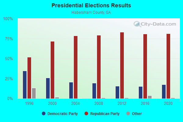
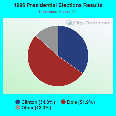
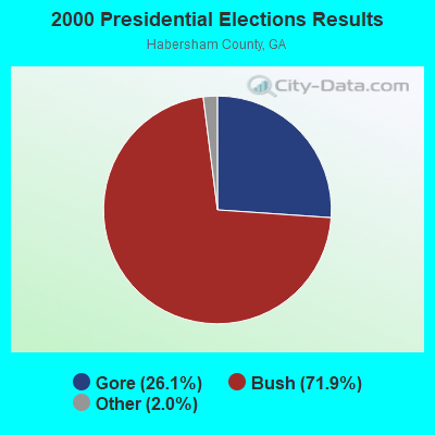
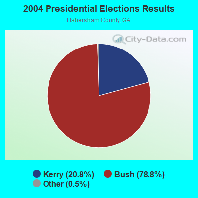
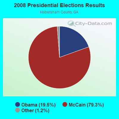
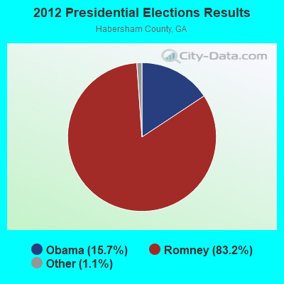
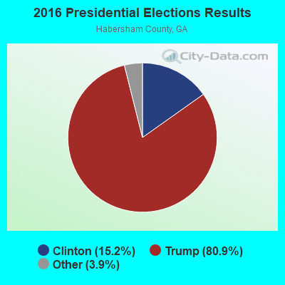
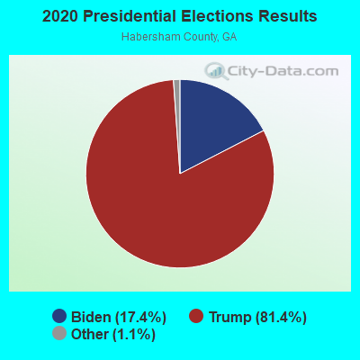
Graphs represent county-level data. Detailed 2008 Election Results
Religion statistics for Turnerville, GA (based on Habersham County data)
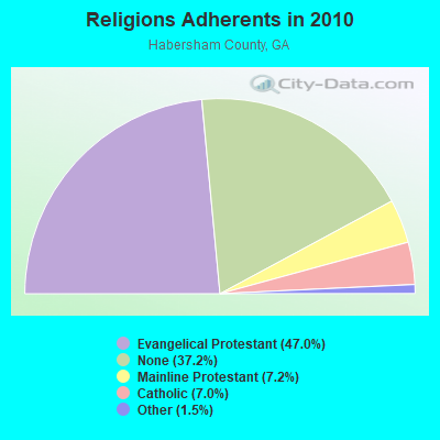
| Religion | Adherents | Congregations |
|---|---|---|
| Evangelical Protestant | 20,247 | 68 |
| Mainline Protestant | 3,103 | 14 |
| Catholic | 3,028 | 1 |
| Other | 649 | 2 |
| None | 16,014 | - |
Food Environment Statistics:
| This county: | 1.66 / 10,000 pop. |
| State: | 1.91 / 10,000 pop. |
| Habersham County: | 0.47 / 10,000 pop. |
| Georgia: | 0.86 / 10,000 pop. |
| Habersham County: | 7.36 / 10,000 pop. |
| State: | 5.12 / 10,000 pop. |
| Habersham County: | 6.88 / 10,000 pop. |
| Georgia: | 7.41 / 10,000 pop. |
| This county: | 10.6% |
| Georgia: | 10.4% |
| Habersham County: | 25.9% |
| State: | 27.8% |
| This county: | 19.7% |
| Georgia: | 14.6% |
Strongest AM radio stations in Turnerville:
- WLET (1420 AM; 5 kW; TOCCOA, GA; Owner: TOCCOA FALLS COLLEGE)
- WLFJ (660 AM; daytime; 50 kW; GREENVILLE, SC; Owner: CLEAR CHANNEL BROADCASTING LICENSES, INC.)
- WDUN (550 AM; 10 kW; GAINESVILLE, GA; Owner: JWJ PROPERTIRS, INC.)
- WCNN (680 AM; 50 kW; NORTH ATLANTA, GA; Owner: DICKEY BROADCASTING COMPANY)
- WCSZ (1070 AM; 50 kW; SANS SOUCI, SC; Owner: WHYZ RADIO, L.P.)
- WCHM (1490 AM; 1 kW; CLARKESVILLE, GA; Owner: BRIAN ROTHELL)
- WSB (750 AM; 50 kW; ATLANTA, GA; Owner: CXR HOLDINGS, INC.)
- WGHC (1370 AM; daytime; 2 kW; CLAYTON, GA; Owner: SUTTON RADIOCASTING CORPORATION)
- WGST (640 AM; 50 kW; ATLANTA, GA; Owner: CITICASTERS LICENSES, L.P.)
- WNEG (630 AM; 0 kW; TOCCOA, GA; Owner: GEORGIA-CAROLINA RADIOCASTING COMPANY, LLC)
- WLBA (1130 AM; daytime; 10 kW; GAINESVILLE, GA)
- WDGR (1210 AM; daytime; 10 kW; DAHLONEGA, GA; Owner: SMALL TOWN RADIO OF GEORGIA, INC.)
- WGUN (1010 AM; 50 kW; ATLANTA, GA; Owner: WGUN, INC.)
Strongest FM radio stations in Turnerville:
- WRAF (90.9 FM; TOCCOA FALLS, GA; Owner: TOCCOA FALLS COLLEGE)
- WRBN (104.1 FM; CLAYTON, GA; Owner: SUTTON RADIOCASTING CORPORATION)
- WFQS (91.3 FM; FRANKLIN, NC; Owner: WESTERN NORTH CAROLINA PUBLIC RADIO)
- WNGC (106.1 FM; TOCCOA, GA; Owner: SOUTHERN BROADCASTING OF PENSACOLA, INC)
- WCON-FM (99.3 FM; CORNELIA, GA; Owner: HABERSHAM BROADCASTING CO.)
- WHEL (105.1 FM; HELEN, GA; Owner: CITICASTERS LICENSES, L.P.)
- WPPR (88.3 FM; DEMOREST, GA; Owner: GEORGIA PUBLIC TELECOMMUNICATIONS COMMISSION)
- W269AY (101.7 FM; HIGHLANDS, NC; Owner: WESTERN NORTH CAROLINA PUBLIC RADIO)
- WHZT (98.1 FM; SENECA, SC; Owner: CXR HOLDINGS, INC.)
- WAZX-FM (101.9 FM; CLEVELAND, GA; Owner: WAZX-FM, INC)
- W277AL (103.3 FM; HIGHLANDS, NC; Owner: CHARISMA RADIO CORPORATION)
- WCVP-FM (95.9 FM; ROBBINSVILLE, NC; Owner: CHEROKEE BROADCASTING COMPANY, INC.)
- WHLC (104.5 FM; HIGHLANDS, NC; Owner: CHARISMA RADIO CORP.)
- WTFH (89.9 FM; HELEN, GA; Owner: TOCCOA FALLS COLLEGE)
- WMJE (102.9 FM; CLARKESVILLE, GA; Owner: JWJ PROPERTIES, INC.)
- WBTS (95.5 FM; ATHENS, GA; Owner: CXR HOLDINGS, INC.)
- W237AR (95.3 FM; HAZELWOOD, ETC., NC; Owner: WESTERN NORTH CAROLINA PUBLIC RADIO)
- WKSF (99.9 FM; ASHEVILLE, NC; Owner: CAPSTAR TX LIMITED PARTNERSHIP)
- WFOX (97.1 FM; GAINESVILLE, GA; Owner: COX RADIO, INC.)
- WTXR (89.7 FM; TOCCOA FALLS, GA; Owner: TOCCOA FALLS COLLEGE)
TV broadcast stations around Turnerville:
- WNEG-TV (Channel 32; TOCCOA, GA; Owner: MEDIA GENERAL BROADCASTING OF SO. CAROLINA HOLDINGS, INC.)
- W50AB (Channel 50; HIAWASSEE, GA; Owner: GEORGIA PUBLIC TELECOMMUNICATIONS COMMISSION)
- W22AC (Channel 22; HARTWELL & ROYSTON, GA; Owner: GEORGIA PUBLIC TELECOMMUNICATIONS COMMISSION)
- WHNS (Channel 21; ASHEVILLE, NC; Owner: MEREDITH CORPORATION)
- W68AF (Channel 68; TOCCOA, GA; Owner: GEORGIA PUBLIC TELECOMMUNICATIONS COMMISSION)

Turnerville fatal accident list:
FCC Registered Amateur Radio Licenses:
7- Call Sign: KG4CVZ, Licensee ID: L01483301, Grant Date: 04/15/2009, Expiration Date: 04/15/2019, Cancellation Date: 04/16/2021, Certifier: Shane L Adams, Registrant: Shane L Adams, Turnerville, GA 30580
- Call Sign: KG4DFO, Licensee ID: L00237083, Grant Date: 06/01/1999, Expiration Date: 05/12/2009, Cancellation Date: 08/01/2000, Registrant: Kerry W Montgomery, Turnerville, GA 30580
- Call Sign: WB4VCP, Licensee ID: L01218895, Grant Date: 12/08/2016, Expiration Date: 02/14/2027, Certifier: Kenneth Franklin, Registrant: Kenneth Franklin, Turnerville, GA 30580
- Call Sign: KW4TB, Previous Call Sign: KG4DFO, Licensee ID: L00237083, Grant Date: 07/03/2020, Expiration Date: 08/01/2030, Certifier: Kerry W Montgomery, Registrant: Kerry W Montgomery, Turnerville, GA 30580
- Call Sign: W2BBQ, Previous Call Sign: KE4ENX, Licensee ID: L00705771, Grant Date: 12/12/2015, Expiration Date: 01/25/2026, Certifier: Woodbury M Parr, Registrant: Woodbury M Parr, Turnerville, GA 30580-0193
- Call Sign: KK4TOF, Licensee ID: L01810087, Grant Date: 08/27/2013, Expiration Date: 08/27/2023, Cancellation Date: 03/23/2021, Certifier: Woodbury M Parr, Registrant: Habersham Amateur Radio Club, 193, Turnerville, GA 30580-0193
- Call Sign: WX4BBQ, Previous Call Sign: KK4TOF, Licensee ID: L01810087, Grant Date: 03/23/2021, Expiration Date: 03/23/2031, Certifier: Woodbury M Parr, Registrant: Habersham Amateur Radio Club, 193, Turnerville, GA 30580-0193

- 47.4%Bottled, tank, or LP gas
- 41.5%Electricity
- 8.6%Wood
- 1.9%Utility gas
- 0.6%Fuel oil, kerosene, etc.

- 72.0%Bottled, tank, or LP gas
- 23.8%Electricity
- 4.1%Fuel oil, kerosene, etc.
Turnerville compared to Georgia state average:
- Unemployed percentage significantly below state average.
- Black race population percentage significantly below state average.
- Hispanic race population percentage significantly below state average.
- Foreign-born population percentage significantly below state average.
- Renting percentage below state average.
- Length of stay since moving in significantly above state average.
- Number of rooms per house significantly below state average.
- House age significantly below state average.
- Number of college students below state average.