Trosper, Kentucky
Submit your own pictures of this place and show them to the world
- OSM Map
- General Map
- Google Map
- MSN Map

| Males: 579 | |
| Females: 559 |
| Median resident age: | 36.6 years |
| Kentucky median age: | 35.9 years |
Zip code: 40995
| Trosper: | $36,101 |
| KY: | $59,341 |
Estimated per capita income in 2022: $18,534 (it was $9,433 in 2000)
Trosper CCD income, earnings, and wages data
Estimated median house or condo value in 2022: $82,130 (it was $29,500 in 2000)
| Trosper: | $82,130 |
| KY: | $196,300 |
Detailed information about poverty and poor residents in Trosper, KY


- 1,10498.3%White alone
- 100.9%Hispanic
- 40.4%American Indian alone
- 20.2%Other race alone
- 10.09%Black alone
- 10.09%Asian alone
- 10.09%Two or more races

Races in Trosper detailed stats: ancestries, foreign born residents, place of birth
 Recent articles from our blog. Our writers, many of them Ph.D. graduates or candidates, create easy-to-read articles on a wide variety of topics.
Current Local Time: EST time zone
Land area: 33.4 square miles.
Population density: 34 people per square mile (very low).

| Trosper CCD: | 0.7% ($212) |
| Kentucky: | 0.8% ($610) |
Nearest city with pop. 50,000+: Knoxville, TN  (56.9 miles , pop. 173,890).
Nearest city with pop. 200,000+: Fayette, KY (93.3 miles , pop. 260,512).
Nearest city with pop. 1,000,000+: Chicago, IL (405.6 miles , pop. 2,896,016).
Nearest cities:
), ), ), ), ), Latitude: 36.79 N, Longitude: 83.83 W
Area code commonly used in this area: 606


| Here: | 5.4% |
| Kentucky: | 3.8% |

- Educational services (12.1%)
- Health care (8.2%)
- Construction (6.8%)
- Machinery (5.5%)
- Mining, quarrying, oil & gas extraction (5.2%)
- Public administration (4.7%)
- Social assistance (4.7%)

- Construction (12.6%)
- Mining, quarrying, oil & gas extraction (9.5%)
- Utilities (6.5%)
- Used merchandise, gift, novelty, souvenir, other miscellaneous stores (6.0%)
- Truck transportation (6.0%)
- Recyclable material merchant wholesalers (5.5%)
- Public administration (5.5%)

- Educational services (26.5%)
- Health care (18.1%)
- Food & beverage stores (7.8%)
- Machinery (6.6%)
- Real estate & rental & leasing (6.6%)
- Finance & insurance (4.8%)
- Printing & related support activities (4.2%)

- Other production occupations, including supervisors (8.2%)
- Assemblers and fabricators (7.1%)
- Counselors, social workers, and other community and social service specialists (6.8%)
- Construction traders workers except carpenters, electricians, painters, plumbers, and construction laborers (6.6%)
- Other management occupations, except farmers and farm managers (4.7%)
- Financial clerks, except bookkeeping, accounting and auditing clerks (4.1%)
- Laborers and material movers, hand (4.1%)

- Construction traders workers except carpenters, electricians, painters, plumbers, and construction laborers (12.1%)
- Assemblers and fabricators (7.5%)
- Laborers and material movers, hand (7.5%)
- Top executives (6.5%)
- Other production occupations, including supervisors (6.0%)
- Driver/sales workers and truck drivers (6.0%)
- Law enforcement workers, including supervisors (5.5%)

- Other production occupations, including supervisors (10.8%)
- Financial clerks, except bookkeeping, accounting and auditing clerks (9.0%)
- Counselors, social workers, and other community and social service specialists (8.4%)
- Registered nurses (7.8%)
- Other teachers, instructors, education, training, and library occupations (7.2%)
- Other management occupations, except farmers and farm managers (6.6%)
- Health technologists and technicians (6.6%)
Average climate in Trosper, Kentucky
Based on data reported by over 4,000 weather stations


(lower is better)

Air Quality Index (AQI) level in 2023 was 80.8. This is about average.
| City: | 80.8 |
| U.S.: | 72.6 |

Carbon Monoxide (CO) [ppm] level in 2000 was 0.127. This is significantly better than average. Closest monitor was 13.5 miles away from the city center.
| City: | 0.127 |
| U.S.: | 0.251 |

Ozone [ppb] level in 2023 was 31.0. This is about average. Closest monitor was 13.5 miles away from the city center.
| City: | 31.0 |
| U.S.: | 33.3 |

Particulate Matter (PM2.5) [µg/m3] level in 2022 was 9.68. This is about average. Closest monitor was 13.5 miles away from the city center.
| City: | 9.68 |
| U.S.: | 8.11 |
Tornado activity:
Trosper-area historical tornado activity is below Kentucky state average. It is 34% smaller than the overall U.S. average.
On 5/9/1988, a category F3 (max. wind speeds 158-206 mph) tornado 13.8 miles away from the Trosper place center killed one person and injured 15 people and caused between $5,000,000 and $50,000,000 in damages.
On 4/3/1974, a category F4 (max. wind speeds 207-260 mph) tornado 39.1 miles away from the place center .
Earthquake activity:
Trosper-area historical earthquake activity is significantly above Kentucky state average. It is 68% greater than the overall U.S. average.On 7/27/1980 at 18:52:21, a magnitude 5.2 (5.1 MB, 4.7 MS, 5.0 UK, 5.2 UK, Class: Moderate, Intensity: VI - VII) earthquake occurred 98.1 miles away from the city center
On 8/9/2020 at 12:07:37, a magnitude 5.1 (5.1 MW, Depth: 4.7 mi) earthquake occurred 153.2 miles away from Trosper center
On 11/30/1973 at 07:48:41, a magnitude 4.7 (4.7 MB, 4.6 ML, Class: Light, Intensity: IV - V) earthquake occurred 69.0 miles away from the city center
On 4/18/2008 at 09:36:59, a magnitude 5.4 (5.1 MB, 4.8 MS, 5.4 MW, 5.2 MW) earthquake occurred 250.4 miles away from the city center
On 9/7/1988 at 02:28:09, a magnitude 4.6 (4.5 MB, 4.6 LG) earthquake occurred 93.6 miles away from Trosper center
On 8/23/2011 at 17:51:04, a magnitude 5.8 (5.8 MW, Depth: 3.7 mi) earthquake occurred 332.9 miles away from Trosper center
Magnitude types: regional Lg-wave magnitude (LG), body-wave magnitude (MB), local magnitude (ML), surface-wave magnitude (MS), moment magnitude (MW)
Natural disasters:
The number of natural disasters in Knox County (31) is a lot greater than the US average (15).Major Disasters (Presidential) Declared: 24
Emergencies Declared: 2
Causes of natural disasters: Floods: 22, Storms: 19, Mudslides: 8, Tornadoes: 7, Landslides: 6, Winter Storms: 5, Fires: 2, Snows: 2, Snowstorms: 2, Winds: 2, Blizzard: 1, Freeze: 1, Hurricane: 1, Snowfall: 1, Other: 1 (Note: some incidents may be assigned to more than one category).
Hospitals and medical centers near Trosper:
- PINEVILLE COMMUNITY HOSPITAL Acute Care Hospitals (about 7 miles away; PINEVILLE, KY)
- BARBOURVILLE HEALTH AND REHABILITATION CENTER (Nursing Home, about 7 miles away; BARBOURVILLE, KY)
- MIDDLESBORO HEALTH CARE FACILITY (Nursing Home, about 13 miles away; MIDDLESBORO, KY)
- MIDDLESBORO APPALACHIAN REGIONAL HEALTHCARE HOSPIT Acute Care Hospitals (about 14 miles away; MIDDLESBORO, KY)
- MIDDLESBORO ARH HOME HEALTH AGENCY (Home Health Center, about 15 miles away; MIDDLESBORO, KY)
- AMEDISYS HOME HEALTH CARE (Home Health Center, about 15 miles away; MIDDLESBORO, KY)
Colleges/universities with over 2000 students nearest to Trosper:
- Lincoln Memorial University (about 18 miles; Harrogate, TN; Full-time enrollment: 3,706)
- University of the Cumberlands (about 20 miles; Williamsburg, KY; FT enrollment: 3,585)
- Hazard Community and Technical College (about 48 miles; Hazard, KY; FT enrollment: 2,087)
- Somerset Community College (about 48 miles; Somerset, KY; FT enrollment: 4,698)
- Southeast Kentucky Community and Technical College (about 48 miles; Cumberland, KY; FT enrollment: 2,196)
- Walters State Community College (about 51 miles; Morristown, TN; FT enrollment: 4,359)
- The University of Tennessee-Knoxville (about 59 miles; Knoxville, TN; FT enrollment: 25,483)
Points of interest:
Notable locations in Trosper: Powers Coal Camp (A), Artemus Volunteer Fire Department Station 2 (B). Display/hide their locations on the map
Churches in Trosper include: Powers Chapel (A), Lower Coalport Church (B), Myrick Church (C), Poplar Grove Church (D), Brush Creek Church (E), Davis Chapel (F). Display/hide their locations on the map
Cemeteries: Tinsley Cemetery (1), Burch Cemetery (2), Jones Cemetery (3), Amis Cemetery (4), Mills Cemetery (5), Miller Cemetery (6), Davis Cemetery (7). Display/hide their locations on the map
Streams, rivers, and creeks: Blue Hole Branch (A), Brush Creek (B), Wolfe Pen Branch (C), Tye Fork (D), Coon Branch (E), Pigeon Roost Branch (F), Tinsley Branch (G), Chestnut Branch (H), Tallow Branch (I). Display/hide their locations on the map
| This place: | 2.4 people |
| Kentucky: | 2.5 people |
| This place: | 71.0% |
| Whole state: | 66.9% |
| This place: | 6.9% |
| Whole state: | 6.4% |
Likely homosexual households (counted as self-reported same-sex unmarried-partner households)
- Lesbian couples: 0.3% of all households
- Gay men: 0.8% of all households
| This place: | 34.1% |
| Whole state: | 15.8% |
| This place: | 20.8% |
| Whole state: | 6.6% |
For population 15 years and over in Trosper:

- Never married: 21.3%
- Now married: 62.2%
- Separated: 1.4%
- Widowed: 7.1%
- Divorced: 9.4%
For population 25 years and over in Trosper:
- High school or higher: 50.4%
- Bachelor's degree or higher: 4.9%
- Graduate or professional degree: 1.0%
- Unemployed: 10.1%
- Mean travel time to work (commute): 38.3 minutes


| Here: | 20.4 |
| Kentucky average: | 13.8 |
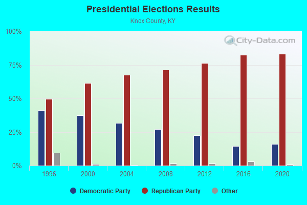
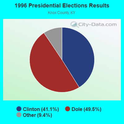
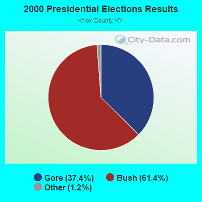
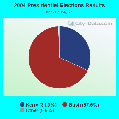
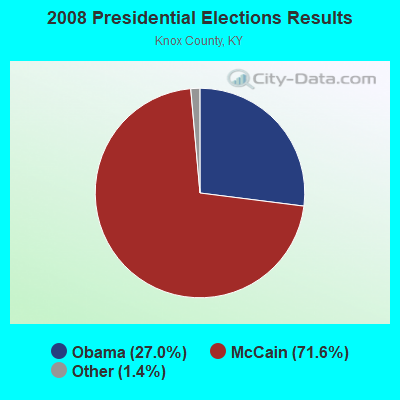
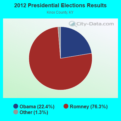
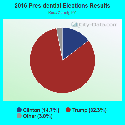
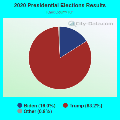
Graphs represent county-level data. Detailed 2008 Election Results
Religion statistics for Trosper, KY (based on Knox County data)
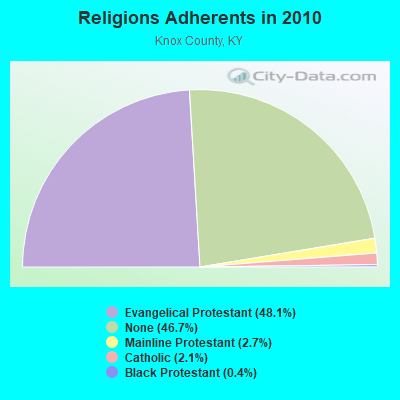
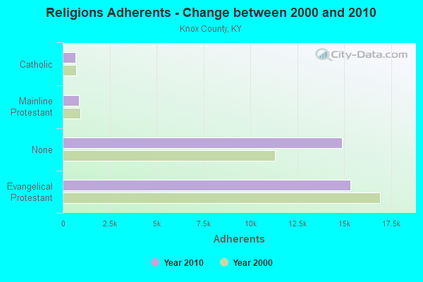
| Religion | Adherents | Congregations |
|---|---|---|
| Evangelical Protestant | 15,334 | 56 |
| Mainline Protestant | 859 | 5 |
| Catholic | 678 | 2 |
| Black Protestant | 123 | 1 |
| Other | - | 1 |
| None | 14,889 | - |
Food Environment Statistics:
| Here: | 2.77 / 10,000 pop. |
| Kentucky: | 2.19 / 10,000 pop. |
| This county: | 0.31 / 10,000 pop. |
| Kentucky: | 0.74 / 10,000 pop. |
| This county: | 3.38 / 10,000 pop. |
| Kentucky: | 4.36 / 10,000 pop. |
| Knox County: | 3.38 / 10,000 pop. |
| Kentucky: | 5.74 / 10,000 pop. |
| This county: | 11.6% |
| State: | 11.0% |
| Knox County: | 32.3% |
| Kentucky: | 30.0% |
| Knox County: | 21.0% |
| Kentucky: | 15.9% |
Strongest AM radio stations in Trosper:
- WYWY (950 AM; 1 kW; BARBOURVILLE, KY; Owner: BARBOURVILLE-COMMNITY BROADC/G CO IN)
- WMIK (560 AM; 2 kW; MIDDLESBORO, KY; Owner: GATEWAY BROADCASTING, INC.)
- WKVL (850 AM; daytime; 50 kW; KNOXVILLE, TN; Owner: HORNE RADIO, LLC)
- WANO (1230 AM; 1 kW; PINEVILLE, KY; Owner: CUMBERLAND MEDIA GROUP, INC.)
- WEKC (710 AM; daytime; 4 kW; WILLIAMSBURG, KY; Owner: GERALD PARKS)
- WKDP (1330 AM; 5 kW; CORBIN, KY; Owner: EUBANKS BROADCASTING, INC.)
- WKLB (1290 AM; 5 kW; MANCHESTER, KY; Owner: BARKER BROADCASTING COMPANY, INC.)
- WFSR (970 AM; 5 kW; HARLAN, KY; Owner: EASTERN BROADCASTING COMPAY)
- WHLN (1410 AM; 5 kW; HARLAN, KY)
- WEZJ (1440 AM; 2 kW; WILLIAMSBURG, KY; Owner: WHITLEY BROADCASTING CO., INC.)
- WCTT (680 AM; 1 kW; CORBIN, KY; Owner: ENCORE COMMUNICATIONS, INC)
- WRWB (740 AM; 1 kW; HARROGATE, TN; Owner: PINE HILLS OF TENNESSEE, INC.)
- WNOX (990 AM; 10 kW; KNOXVILLE, TN)
Strongest FM radio stations in Trosper:
- WRIL (106.3 FM; PINEVILLE, KY; Owner: PINE HILLS BROADCASTING, INC.)
- WMIK-FM (92.7 FM; MIDDLESBORO, KY; Owner: GATEWAY BROADCASTING, INC.)
- WKKQ (96.1 FM; BARBOURVILLE, KY; Owner: BARBOURVILLE COMMUNITY B/NG CO.INC.)
- WKDP-FM (99.5 FM; CORBIN, KY; Owner: EUBANKS BROADCASTING, INC.)
- WEKX (102.7 FM; JELLICO, TN; Owner: WHITLEY BROADCASTING CO., INC.)
- WCTU (105.9 FM; TAZEWELL, TN; Owner: STAIR COMPANY, INC)
- WCTT-FM (107.3 FM; CORBIN, KY; Owner: ENCORE COMMUNICATIONS, INC.)
- WEZJ-FM (104.3 FM; WILLIAMSBURG, KY; Owner: WHITLEY BROADCASTING CO., INC.)
- WDVX (89.9 FM; CLINTON, TN; Owner: CUMBERLAND COMMUNITIES COMMUNI CORP.)
- WTUK (105.1 FM; HARLAN, KY; Owner: EASTERN BROADCASTING COMPANY)
- WIMZ-FM (103.5 FM; KNOXVILLE, TN; Owner: SOUTH CENTRAL COMM., CORP.)
- WSEH (102.7 FM; CUMBERLAND, KY; Owner: CUMBERLAND CITY BROADCASTING, INC.)
- WWLT (103.1 FM; MANCHESTER, KY; Owner: VERNON R. BALDWIN, INC.)
- WAXM (93.5 FM; BIG STONE GAP, VA; Owner: VALLEY BROADCASTING, INC.)
- WSGS (101.1 FM; HAZARD, KY; Owner: MOUNTAIN BROADCASTING SERVICE, INC.)
- WOKI-FM (100.3 FM; OAK RIDGE, TN; Owner: OAK RIDGE FM, INC.)
- WJDT (106.5 FM; ROGERSVILLE, TN; Owner: C & S BROADCASTING)
- WBGQ (100.7 FM; BULLS GAP, TN; Owner: CHEROKEE BROADCASTING)
- WYGE (92.3 FM; LONDON, KY; Owner: ETHEL HUFF BROADCASTING, LLC)
- WUOT (91.9 FM; KNOXVILLE, TN; Owner: UNIVERSITY OF TENNESSEE)
TV broadcast stations around Trosper:
- WKOP-TV (Channel 15; KNOXVILLE, TN; Owner: EAST TENNESSEE PUBLIC COMMUNICATIONS CORP.)
- WAGV (Channel 44; HARLAN, KY; Owner: LIVING FAITH MINISTRIES, INC.)
- WVTN-LP (Channel 48; CORBIN, KY; Owner: VICTORY TRAINING SCHOOL CORP.)
- W33BK (Channel 33; CORBIN, KY; Owner: TRINITY BROADCASTING NETWORK)
- W39CK (Channel 20; CORBIN, KY; Owner: DEREK RAY EUBANKS)
- W07AH (Channel 7; BARBOURVILLE, KY; Owner: BARBOURVILLE AREA TELEVISION CORP.)
- W04AF (Channel 4; BARBOURVILLE, KY; Owner: BARBOURVILLE AREA TELEVISION CORP.)
Trosper fatal accident list:
Oct 1, 2003 07:07 PM, Sr-225, Vehicles: 1, Persons: 1, Fatalities: 1, Drunk persons involved: 1
Aug 14, 1999 09:30 PM, Sr-225, Vehicles: 1, Persons: 2, Fatalities: 1
Sep 15, 1998 12:20 AM, Sr-225, Vehicles: 2, Persons: 4, Fatalities: 1
Aug 7, 1993 02:15 AM, 225, Vehicles: 1, Persons: 2, Fatalities: 1, Drunk persons involved: 1

- 43.4%Electricity
- 22.3%Coal or coke
- 13.8%Utility gas
- 9.7%Fuel oil, kerosene, etc.
- 7.0%Bottled, tank, or LP gas
- 3.8%Wood

- 39.0%Electricity
- 30.0%Utility gas
- 18.0%Fuel oil, kerosene, etc.
- 7.0%Coal or coke
- 6.0%Bottled, tank, or LP gas
Trosper compared to Kentucky state average:
- Median household income below state average.
- Median house value significantly below state average.
- Black race population percentage significantly below state average.
- Hispanic race population percentage significantly below state average.
- Median age below state average.
- Foreign-born population percentage significantly below state average.
- Renting percentage below state average.
- Length of stay since moving in significantly above state average.
- Number of rooms per house significantly below state average.
- House age significantly below state average.
- Number of college students significantly below state average.
- Percentage of population with a bachelor's degree or higher significantly below state average.