Thurston, Georgia
Submit your own pictures of this place and show them to the world
- OSM Map
- General Map
- Google Map
- MSN Map

| Males: 1,674 | |
| Females: 1,754 |
| Median resident age: | 37.2 years |
| Georgia median age: | 33.4 years |
Zip code: 30286
| Thurston: | $56,743 |
| GA: | $72,837 |
Estimated per capita income in 2022: $27,949 (it was $16,838 in 2000)
Thurston CCD income, earnings, and wages data
Estimated median house or condo value in 2022: $171,629 (it was $65,600 in 2000)
| Thurston: | $171,629 |
| GA: | $297,400 |
Mean prices in 2022: all housing units: $165,123; detached houses: $173,080; townhouses or other attached units: $211,782; mobile homes: $84,670
Detailed information about poverty and poor residents in Thurston, GA
Compare current foreclosures near Thurston, GA:
| Photo | Address | Area | Beds / Baths | Price | Details |
|---|---|---|---|---|---|

|
#1
Avenue J
Thomaston, GA 30286
|
896 sq. feet
|
1 baths 2 beds |
show details | |

|
#2
N Old Alabama Rd
Thomaston, GA 30286
|
1,445 sq. feet
|
2 baths 3 beds |
show details | |

|
#3
Honeysuckle Ln
Zebulon, GA 30295
|
1,782 sq. feet
|
2 baths 3 beds |
show details | |

|
#4
Logtown Rd
Yatesville, GA 31097
|
2,573 sq. feet
|
4 baths 4 beds |
show details | |

|
#5
Concord St
Zebulon, GA 30295
|
2,516 sq. feet
|
3 baths 3 beds |
show details | |

|
#6
Griffin Ave
Thomaston, GA 30286
|
2,844 sq. feet
|
2 baths 4 beds |
show details | |

|
#7
Meadow Dr
Thomaston, GA 30286
|
1,661 sq. feet
|
1 baths 2 beds |
show details | |

|
#8
Mulberry St
Thomaston, GA 30286
|
1,296 sq. feet
|
1 baths 2 beds |
show details | |

|
#9
Mulberry St
Thomaston, GA 30286
|
1,232 sq. feet
|
2 baths 3 beds |
show details | |

|
#10
Pine Knoll Dr
Warm Springs, GA 31830
|
1,827 sq. feet
|
2 baths 3 beds |
show details |
| Photo | Address | Area | Beds / Baths | Price | Details |
|---|---|---|---|---|---|

|
#11
Logtown Rd
Yatesville, GA 31097
|
1,024 sq. feet
|
1 baths 2 beds |
show details | |

|
#12
Trice Rd
Thomaston, GA 30286
|
1,323 sq. feet
|
1 baths 2 beds |
show details | |

|
#13
Creekside Manor Dr
Thomaston, GA 30286
|
1,512 sq. feet
|
2 baths 3 beds |
show details | |

|
#14
G Cir
Thomaston, GA 30286
|
1,410 sq. feet
|
1 baths 2 beds |
show details | |

|
#15
Roberta Rd
Manchester, GA 31816
|
1,735 sq. feet
|
2 baths 3 beds |
show details | |

|
#16
Pineview Dr
Thomaston, GA 30286
|
1,316 sq. feet
|
1 baths 2 beds |
show details | |

|
#17
Meadow Dr
Thomaston, GA 30286
|
1,248 sq. feet
|
1 baths 3 beds |
show details | |

|
#18
Temple Dukes Rd
Woodbury, GA 30293
|
1,716 sq. feet
|
2 baths 3 beds |
show details | |

|
#19
Tom Mckinley Rd
Thomaston, GA 30286
|
1,680 sq. feet
|
2 baths 3 beds |
show details | |

|
#20
Pershing St
Manchester, GA 31816
|
1,352 sq. feet
|
2 baths 5 beds |
show details |
| Photo | Address | Area | Beds / Baths | Price | Details |
|---|---|---|---|---|---|

|
#21
Judson Bulloch Rd
Warm Springs, GA 31830
|
1,740 sq. feet
|
3 baths 3 beds |
show details | |

|
#22
Carroll Chunn Rd
Woodbury, GA 30293
|
1,348 sq. feet
|
1 baths 3 beds |
show details | |

|
#23
Hawkins Rd
Woodland, GA 31836
|
960 sq. feet
|
1 baths 3 beds |
show details | |

|
#24
Manchester Hwy
Woodland, GA 31836
|
1,198 sq. feet
|
2 baths 3 beds |
show details | |

|
#25
River Rd
Manchester, GA 31816
|
1,710 sq. feet
|
1 baths 3 beds |
show details | |

|
#26
Potato Creek Rd
The Rock, GA 30285
|
1,568 sq. feet
|
2 baths 4 beds |
show details | |

|
#27
Dromedary St
Woodbury, GA 30293
|
1,242 sq. feet
|
1 baths 3 beds |
show details | |

|
#28
Ponderosa Ln
Barnesville, GA 30204
|
1,976 sq. feet
|
3 baths 3 beds |
show details | |

|
#29
Creekside Ct
Zebulon, GA 30295
|
768 sq. feet
|
4 baths 4 beds |
show details | |

|
#30
Stewart Rd
Meansville, GA 30256
|
1,248 sq. feet
|
2 baths 3 beds |
show details |
| Photo | Address | Area | Beds / Baths | Price | Details |
|---|---|---|---|---|---|

|
#31
Grant Ave
Manchester, GA 31816
|
3,144 sq. feet
|
1 baths 3 beds |
show details | |

|
#32
Crescent Rd
Thomaston, GA 30286
|
1,444 sq. feet
|
2 baths 3 beds |
show details | |

|
#33
Hunt Rd
Thomaston, GA 30286
|
1,100 sq. feet
|
1 baths 2 beds |
show details | |

|
#34
Horseshoe Bnd
Thomaston, GA 30286
|
2,116 sq. feet
|
2 baths 3 beds |
show details | |

|
#35
Pineview Dr
Thomaston, GA 30286
|
1,152 sq. feet
|
2 baths 3 beds |
show details | |

|
#36
Hickman Fork Rd
Thomaston, GA 30286
|
3,794 sq. feet
|
3 baths 2 beds |
show details | |

|
#37
Maynard St
Thomaston, GA 30286
|
1,016 sq. feet
|
1 baths 2 beds |
show details | |

|
#38
Crest Hwy
Molena, GA 30258
|
1,680 sq. feet
|
2 baths 2 beds |
show details | |

|
#39
Geneva Hwy
Talbotton, GA 31827
|
2,417 sq. feet
|
2 baths 4 beds |
show details | |

|
#40
Mcfarlin Rd
Thomaston, GA 30286
|
1,200 sq. feet
|
2 baths 2 beds |
show details |
| Photo | Address | Area | Beds / Baths | Price | Details |
|---|---|---|---|---|---|

|
#41
Pleasant Valley Rd
Molena, GA 30258
|
2,128 sq. feet
|
3 baths 5 beds |
show details | |

|
#42
Gaulding Rd
Concord, GA 30206
|
3,316 sq. feet
|
2 baths 3 beds |
show details | |

|
#43
E Milner Rd
Zebulon, GA 30295
|
2,413 sq. feet
|
2 baths 3 beds |
show details | |

|
#44
Davis Lake Rd
Thomaston, GA 30286
|
1,988 sq. feet
|
2 baths 2 beds |
show details | |

|
#45
S St SW
Thomaston, GA 30286
|
1,232 sq. feet
|
1 baths 2 beds |
show details | |

|
#46
Raines St
Thomaston, GA 30286
|
640 sq. feet
|
2 baths 4 beds |
show details | |

|
#47
Shady Brook Ln
Barnesville, GA 30204
|
1,344 sq. feet
|
2 baths 3 beds |
show details | |

|
#48
Shady Brook Ln
Barnesville, GA 30204
|
1,560 sq. feet
|
3 baths 3 beds |
show details | |

|
#49
G St
Thomaston, GA 30286
|
1,024 sq. feet
|
1 baths 2 beds |
show details | |

|
Check over 1 million property listings on Foreclosure.com!
|
browse all offers | |||

- 3,11690.7%White alone
- 2717.9%Black alone
- 290.8%Two or more races
- 90.3%Hispanic
- 80.2%American Indian alone
- 40.1%Asian alone

Races in Thurston detailed stats: ancestries, foreign born residents, place of birth
 Recent articles from our blog. Our writers, many of them Ph.D. graduates or candidates, create easy-to-read articles on a wide variety of topics.
Current Local Time: EST time zone
Elevation: 540 feet
Land area: 82.2 square miles.
Population density: 42 people per square mile (very low).

| Thurston CCD: | 0.8% ($552) |
| Georgia: | 0.9% ($919) |
Nearest city with pop. 50,000+: Columbus, GA  (41.1 miles , pop. 185,781).
Nearest city with pop. 200,000+: Atlanta, GA (59.2 miles , pop. 416,474).
Nearest city with pop. 1,000,000+: Chicago, IL (643.2 miles , pop. 2,896,016).
Nearest cities:
), Latitude: 32.90 N, Longitude: 84.44 W
Area code commonly used in this area: 706


| Here: | 2.9% |
| Georgia: | 2.9% |

- Construction (11.8%)
- Textile mills & textile products (10.5%)
- Health care (10.4%)
- Educational services (7.8%)
- Accommodation & food services (5.1%)
- Printing & related support activities (5.1%)
- Public administration (4.6%)

- Construction (19.4%)
- Textile mills & textile products (11.0%)
- Printing & related support activities (6.1%)
- Public administration (4.8%)
- Accommodation & food services (4.2%)
- Miscellaneous manufacturing (4.0%)
- Food & beverage stores (3.9%)

- Health care (19.2%)
- Educational services (13.9%)
- Textile mills & textile products (10.0%)
- Accommodation & food services (6.2%)
- Department & other general merchandise stores (5.2%)
- Public administration (4.4%)
- Professional, scientific, technical services (4.0%)

- Other production occupations, including supervisors (6.3%)
- Other management occupations, except farmers and farm managers (5.4%)
- Electrical equipment mechanics and other installation, maintenance, and repair workers, including supervisors (4.3%)
- Textile, apparel, and furnishings workers (4.1%)
- Metal workers and plastic workers (3.9%)
- Other sales and related occupations, including supervisors (3.8%)
- Retail sales workers, except cashiers (3.2%)

- Other production occupations, including supervisors (9.1%)
- Electrical equipment mechanics and other installation, maintenance, and repair workers, including supervisors (8.0%)
- Metal workers and plastic workers (6.1%)
- Building and grounds cleaning and maintenance occupations (5.5%)
- Construction laborers (5.1%)
- Printing workers (4.2%)
- Other sales and related occupations, including supervisors (3.4%)

- Other management occupations, except farmers and farm managers (8.2%)
- Secretaries and administrative assistants (6.7%)
- Textile, apparel, and furnishings workers (5.8%)
- Registered nurses (5.7%)
- Other teachers, instructors, education, training, and library occupations (4.8%)
- Nursing, psychiatric, and home health aides (4.7%)
- Other sales and related occupations, including supervisors (4.2%)
Average climate in Thurston, Georgia
Based on data reported by over 4,000 weather stations


Tornado activity:
Thurston-area historical tornado activity is near Georgia state average. It is 37% greater than the overall U.S. average.
On 12/5/1954, a category F3 (max. wind speeds 158-206 mph) tornado 9.9 miles away from the Thurston place center injured 7 people and caused between $50,000 and $500,000 in damages.
On 1/2/2006, a category F3 tornado 17.0 miles away from the place center injured 3 people and caused $1 million in damages.
Earthquake activity:
Thurston-area historical earthquake activity is significantly above Georgia state average. It is 31% greater than the overall U.S. average.On 4/29/2003 at 08:59:39, a magnitude 4.9 (4.4 MB, 4.6 MW, 4.9 LG, Class: Light, Intensity: IV - V) earthquake occurred 129.7 miles away from Thurston center
On 8/2/1974 at 08:52:09, a magnitude 4.9 (4.3 MB, 4.9 LG) earthquake occurred 130.9 miles away from the city center
On 1/18/1999 at 07:00:53, a magnitude 4.8 (4.8 MB, 4.0 LG, Depth: 0.6 mi) earthquake occurred 166.9 miles away from Thurston center
On 4/29/2003 at 08:59:39, a magnitude 4.6 (4.6 MW, Depth: 12.3 mi) earthquake occurred 129.7 miles away from Thurston center
On 10/24/1997 at 08:35:17, a magnitude 4.9 (4.8 MB, 4.2 MS, 4.9 LG, Depth: 6.2 mi) earthquake occurred 207.0 miles away from the city center
On 11/30/1973 at 07:48:41, a magnitude 4.7 (4.7 MB, 4.6 ML) earthquake occurred 202.0 miles away from Thurston center
Magnitude types: regional Lg-wave magnitude (LG), body-wave magnitude (MB), local magnitude (ML), surface-wave magnitude (MS), moment magnitude (MW)
Natural disasters:
The number of natural disasters in Upson County (16) is near the US average (15).Major Disasters (Presidential) Declared: 10
Emergencies Declared: 4
Causes of natural disasters: Floods: 5, Storms: 5, Tornadoes: 5, Winter Storms: 4, Hurricanes: 3, Winds: 3, Tropical Storms: 2, Drought: 1, Heavy Rain: 1, Snowfall: 1, Other: 1 (Note: some incidents may be assigned to more than one category).
Hospitals and medical centers near Thurston:
- UPSON REGIONAL MEDICAL CENTER Acute Care Hospitals (about 6 miles away; THOMASTON, GA)
- RIVERSIDE HEALTH AND REHABILITATION (Nursing Home, about 7 miles away; THOMASTON, GA)
- RIVERSIDE NURSING CTR OF THOMASTON (Nursing Home, about 7 miles away; THOMASTON, GA)
- THOMASTON HOSPICE, INC (Hospital, about 7 miles away; THOMASTON, GA)
- PROVIDENCE HEALTH AND REHABILITATION CENTER INC (Nursing Home, about 7 miles away; THOMASTON, GA)
- PROVIDENCE HEALTH CARE (Nursing Home, about 7 miles away; THOMASTON, GA)
- GOLDEN LIVINGCENTER - THOMASTON (Nursing Home, about 8 miles away; THOMASTON, GA)
Colleges/universities with over 2000 students nearest to Thurston:
- Gordon State College (about 20 miles; Barnesville, GA; Full-time enrollment: 3,336)
- Southern Crescent Technical College (about 26 miles; Griffin, GA; FT enrollment: 4,168)
- Fort Valley State University (about 41 miles; Fort Valley, GA; FT enrollment: 3,200)
- Columbus State University (about 41 miles; Columbus, GA; FT enrollment: 6,876)
- Middle Georgia State College (about 42 miles; Macon, GA; FT enrollment: 7,091)
- Columbus Technical College (about 42 miles; Columbus, GA; FT enrollment: 3,241)
- Mercer University (about 46 miles; Macon, GA; FT enrollment: 6,297)
Points of interest:
Notable locations in Thurston: Camp Thunder (A), McCrary Minnow Farm (B), Thurston Volunteer Fire and Rescue (C). Display/hide their locations on the map
Churches in Thurston include: Faithful Christian Church (A), Midway Church (B), New Fellowship Church (C), Pleasant Valley Church (D), Hendricks Church (E), Hebron Church (F), Friendship Church (G), Crest Church (H), Springfield Church (I). Display/hide their locations on the map
Cemeteries: Adams Cemetery (1), Flint River Cemetery (2), Friendship Cemetery (3), Hendricks Cemetery (4), Brown Cemetery (5), Smith Cemetery (6), Fellowship Cemetery (7). Display/hide their locations on the map
Reservoirs: Daniel Lake (A), Lake Ellerbee Number 1 (B), Lake Ellerbee Number 2 (C), Hammonds Lake (D), Daniel Lake (E), Hightower Lake (F), Sunnyside Lake (G), Turner Lake (H). Display/hide their locations on the map
Streams, rivers, and creeks: Wright Branch (A), Woodall Branch (B), Womble Creek (C), Turkey Creek (D), Irvin Creek (E), Hurricane Creek (F), Hoyle Branch (G), Elkins Creek (H), Reeves Creek (I). Display/hide their locations on the map
Park in Thurston: Sprewell Bluff Park (1). Display/hide its location on the map
| This place: | 2.6 people |
| Georgia: | 2.6 people |
| This place: | 67.0% |
| Whole state: | 70.7% |
| This place: | 4.3% |
| Whole state: | 4.8% |
Likely homosexual households (counted as self-reported same-sex unmarried-partner households)
- Lesbian couples: 0.3% of all households
- Gay men: 0.1% of all households
| This place: | 11.5% |
| Whole state: | 13.0% |
| This place: | 4.6% |
| Whole state: | 6.1% |
7 people in schools, hospitals, or wards for the intellectually disabled in 2000
For population 15 years and over in Thurston:

- Never married: 17.0%
- Now married: 65.3%
- Separated: 1.6%
- Widowed: 5.9%
- Divorced: 11.7%
For population 25 years and over in Thurston:
- High school or higher: 74.2%
- Bachelor's degree or higher: 8.5%
- Graduate or professional degree: 2.9%
- Unemployed: 5.9%
- Mean travel time to work (commute): 23.2 minutes


| Here: | 10.7 |
| Georgia average: | 13.3 |
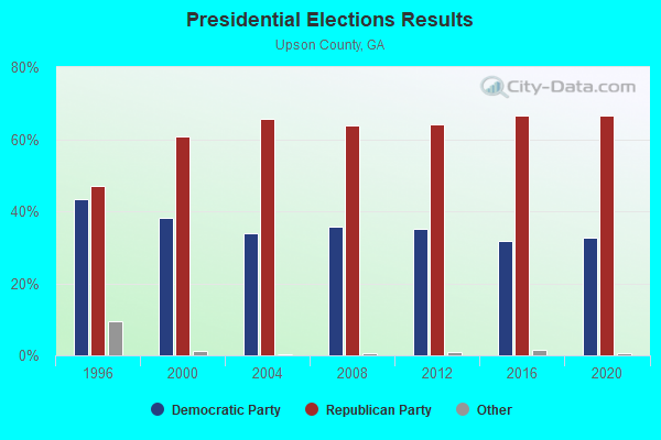
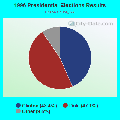
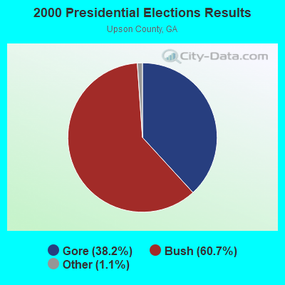

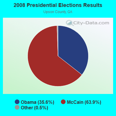
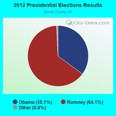

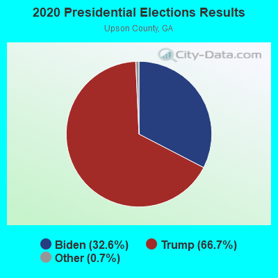
Graphs represent county-level data. Detailed 2008 Election Results
Religion statistics for Thurston, GA (based on Upson County data)
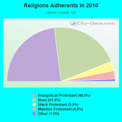
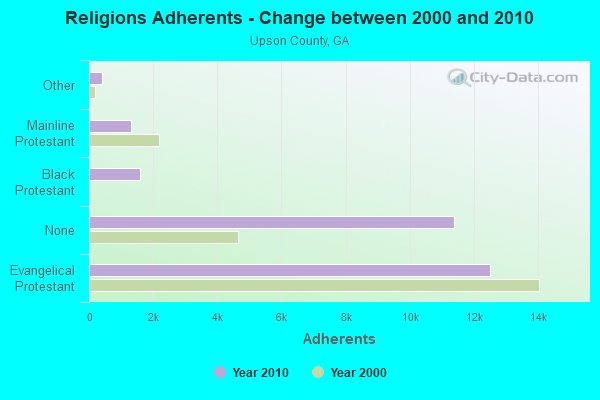
| Religion | Adherents | Congregations |
|---|---|---|
| Evangelical Protestant | 12,490 | 40 |
| Black Protestant | 1,581 | 8 |
| Mainline Protestant | 1,305 | 10 |
| Other | 413 | 2 |
| Catholic | - | - |
| None | 11,364 | - |
Food Environment Statistics:
| Here: | 2.90 / 10,000 pop. |
| Georgia: | 1.91 / 10,000 pop. |
| Upson County: | 0.36 / 10,000 pop. |
| Georgia: | 0.15 / 10,000 pop. |
| This county: | 1.09 / 10,000 pop. |
| Georgia: | 0.86 / 10,000 pop. |
| Here: | 5.08 / 10,000 pop. |
| Georgia: | 5.12 / 10,000 pop. |
| This county: | 8.70 / 10,000 pop. |
| Georgia: | 7.41 / 10,000 pop. |
| Upson County: | 11.9% |
| State: | 10.4% |
| Upson County: | 31.0% |
| State: | 27.8% |
| This county: | 13.1% |
| Georgia: | 14.6% |
Strongest AM radio stations in Thurston:
- WMAC (940 AM; 50 kW; MACON, GA; Owner: CUMULUS LICENSING CORP.)
- WGST (640 AM; 50 kW; ATLANTA, GA; Owner: CITICASTERS LICENSES, L.P.)
- WGUN (1010 AM; 50 kW; ATLANTA, GA; Owner: WGUN, INC.)
- WSB (750 AM; 50 kW; ATLANTA, GA; Owner: CXR HOLDINGS, INC.)
- WCNN (680 AM; 50 kW; NORTH ATLANTA, GA; Owner: DICKEY BROADCASTING COMPANY)
- WAOK (1380 AM; 50 kW; ATLANTA, GA; Owner: INFINITY BROADCASTING OPERATIONS, INC.)
- WMLB (1160 AM; 50 kW; EAST POINT, GA; Owner: ATLANTA AREA BROADCASTING, INC.)
- WGSE (720 AM; daytime; 8 kW; HOGANSVILLE, GA; Owner: CITICASTERS LICENSES, L.P.)
- WQXI (790 AM; 28 kW; ATLANTA, GA; Owner: JEFFERSON-PILOT COMMUNICATIONS COMPANY OF GEORGIA)
- WKNG (1060 AM; daytime; 50 kW; TALLAPOOSA, GA; Owner: WKNG, INC.)
- WFDR (1370 AM; 1 kW; MANCHESTER, GA)
- WFTD (1080 AM; daytime; 50 kW; MARIETTA, GA; Owner: PRIETO ENTERPRISES, INC.)
- WAZX (1550 AM; 50 kW; SMYRNA, GA; Owner: GA-MEX BROADCASTING, INC.)
Strongest FM radio stations in Thurston:
- WTGA-FM (101.1 FM; THOMASTON, GA; Owner: RADIO GEORGIA, INC.)
- WVFJ-FM (93.3 FM; MANCHESTER, GA; Owner: PROVIDENT BROADCASTING COMPANY)
- WKEU-FM (88.9 FM; THE ROCK, GA; Owner: GEORGIA FOUNDATION OF PUBLIC BROADCASTING, INC.)
- WJSP-FM (88.1 FM; WARM SPRINGS, GA; Owner: GEORGIA PUBLIC TELECOMMUNICATIONS COMMISSION)
- WKZJ (95.7 FM; GREENVILLE, GA; Owner: DAVIS B/CASTING OF COLUMBUS, INC)
- WEKS (92.5 FM; ZEBULON, GA; Owner: SPALDING BROADCASTING, INC.)
- WALR-FM (104.1 FM; LA GRANGE, GA; Owner: CXR HOLDINGS, INC.)
- WQMJ (100.1 FM; FORSYTH, GA; Owner: ROBERTS COMMUNICATIONS, INC.)
- WCRU-LP (97.1 FM; THOMASTON, GA; Owner: THOMASTON CHRISTIAN RADIO)
TV broadcast stations around Thurston:
- WJSP-TV (Channel 28; COLUMBUS, GA; Owner: GEORGIA PUBLIC TELECOMMUNICATIONS COMMISSION)
- WTVM (Channel 9; COLUMBUS, GA; Owner: RAYCOM AMERICA, INC.)
- WRBL (Channel 3; COLUMBUS, GA; Owner: MEDIA GENERAL BROADCASTING OF SO. CAROLINA HOLDINGS, INC.)
- WLTZ (Channel 38; COLUMBUS, GA; Owner: LEWIS BROADCASTING CORPORATION)
- WXTX (Channel 54; COLUMBUS, GA; Owner: FISHER BROADCASTING - GEORGIA, L.L.C.)
- W04DB (Channel 4; ATLANTA, GA; Owner: VVILPTV, INC.)
- WSWS-TV (Channel 66; OPELIKA, AL; Owner: PAPPAS TELECASTING OF OPELIKA)

- 45.5%Bottled, tank, or LP gas
- 33.6%Electricity
- 18.2%Utility gas
- 2.0%Wood
- 0.6%Fuel oil, kerosene, etc.

- 55.1%Bottled, tank, or LP gas
- 22.7%Utility gas
- 17.3%Electricity
- 4.9%Wood
Thurston compared to Georgia state average:
- Median house value below state average.
- Unemployed percentage below state average.
- Black race population percentage significantly below state average.
- Hispanic race population percentage significantly below state average.
- Foreign-born population percentage significantly below state average.
- Renting percentage significantly below state average.
- Length of stay since moving in significantly above state average.
- Number of rooms per house significantly below state average.
- House age significantly below state average.
- Institutionalized population percentage significantly above state average.
- Percentage of population with a bachelor's degree or higher significantly below state average.