Three Forks, Kentucky
Submit your own pictures of this place and show them to the world
- OSM Map
- General Map
- Google Map
- MSN Map

| Males: 658 | |
| Females: 615 |
| Median resident age: | 33.9 years |
| Kentucky median age: | 35.9 years |
Zip code: 41250
| Three Forks: | $37,898 |
| KY: | $59,341 |
Estimated per capita income in 2022: $15,246 (it was $7,527 in 2000)
Three Forks CCD income, earnings, and wages data
Estimated median house or condo value in 2022: $104,555 (it was $45,700 in 2000)
| Three Forks: | $104,555 |
| KY: | $196,300 |
Mean prices in 2022: all housing units: $108,221; detached houses: $119,713; mobile homes: $78,795
Detailed information about poverty and poor residents in Three Forks, KY
Compare current foreclosures near Three Forks, KY:
| Photo | Address | Area | Beds / Baths | Price | Details |
|---|---|---|---|---|---|

|
#1
State Highway 1056
Mc Carr, KY 41544
|
1,638 sq. feet
|
1 baths 3 beds |
show details | |

|
#2
Mate Creek Rd
Matewan, WV 25678
|
- sq. feet
|
- baths - beds |
$15,900
|
show details |

|
#3
Fonso Stanley Rd
Canada, KY 41519
|
- sq. feet
|
- baths - beds |
$14,900
|
show details |

|
#4
Clyde Davis Dr
Tomahawk, KY 41262
|
1,232 sq. feet
|
1 baths 3 beds |
show details | |

|
#5
Clevinger Br
Pikeville, KY 41501
|
1,092 sq. feet
|
1 baths 3 beds |
show details | |

|
#6
Calf Br
Ransom, KY 41558
|
864 sq. feet
|
1 baths 2 beds |
show details | |

|
#7
Us Highway 119 N
Belfry, KY 41514
|
2,162 sq. feet
|
1 baths 2 beds |
show details | |

|
#8
Crisp Fitzpatrick Pl
Tomahawk, KY 41262
|
1,344 sq. feet
|
1 baths 3 beds |
show details | |

|
#9
Smith Frk
Ransom, KY 41558
|
1,325 sq. feet
|
1 baths 2 beds |
show details | |

|
#10
Left Turkey Toe Br
Hardy, KY 41531
|
- sq. feet
|
- baths - beds |
$29,900
|
show details |
| Photo | Address | Area | Beds / Baths | Price | Details |
|---|---|---|---|---|---|

|
#11
Morris St
Sidney, KY 41564
|
1,400 sq. feet
|
1 baths 3 beds |
show details | |

|
#12
State Highway 194 E
Kimper, KY 41539
|
3,236 sq. feet
|
2 baths 3 beds |
show details | |

|
#13
Jacobs Ln
Warfield, KY 41267
|
1,965 sq. feet
|
1 baths - beds |
show details | |

|
#14
Tomahawk Rd
Tomahawk, KY 41262
|
- sq. feet
|
- baths - beds |
show details | |

|
#15
Hale Dr
Pilgrim, KY 41250
|
- sq. feet
|
- baths - beds |
show details | |

|
#16
Pond Creek Rd
Stone, KY 41567
|
- sq. feet
|
- baths - beds |
show details | |

|
#17
Tug River Rd
Inez, KY 41224
|
720 sq. feet
|
- baths - beds |
show details | |

|
#18
Morgan Kirk Loop
Inez, KY 41224
|
- sq. feet
|
- baths - beds |
show details | |

|
#19
Newberry Ln
Inez, KY 41224
|
- sq. feet
|
- baths - beds |
show details | |

|
#20
Sycamore Ests
Inez, KY 41224
|
- sq. feet
|
- baths - beds |
show details |
| Photo | Address | Area | Beds / Baths | Price | Details |
|---|---|---|---|---|---|

|
#21
Lauren St
Kimper, KY 41539
|
- sq. feet
|
- baths - beds |
show details | |

|
#22
Garland Spence Dr
Inez, KY 41224
|
- sq. feet
|
- baths - beds |
show details | |

|
#23
S Milo Rd
Tomahawk, KY 41262
|
- sq. feet
|
- baths - beds |
show details | |

|
#24
Spruce Pine Rd
Inez, KY 41224
|
- sq. feet
|
- baths - beds |
show details | |

|
#25
State Highway 194 E
Kimper, KY 41539
|
- sq. feet
|
- baths - beds |
show details | |

|
#26
Ridge Pt
Pikeville, KY 41501
|
- sq. feet
|
- baths - beds |
show details | |

|
#27
Haynes Village Pl
Pikeville, KY 41501
|
- sq. feet
|
- baths - beds |
show details | |

|
#28
Peter Fork Rd
Mc Carr, KY 41544
|
- sq. feet
|
- baths - beds |
show details | |

|
#29
Homemade Holw
Pinsonfork, KY 41555
|
- sq. feet
|
- baths - beds |
show details | |

|
#30
Middle Frk
Ransom, KY 41558
|
- sq. feet
|
- baths - beds |
show details |
| Photo | Address | Area | Beds / Baths | Price | Details |
|---|---|---|---|---|---|

|
#31
Shop Br
Stanville, KY 41659
|
- sq. feet
|
- baths - beds |
show details | |

|
#32
Mountain Enterprise Dr
Inez, KY 41224
|
- sq. feet
|
- baths - beds |
show details | |

|
#33
Lick Skillet Rd
Kermit, WV 25674
|
- sq. feet
|
- baths - beds |
show details | |

|
#34
Hale Dr
Pilgrim, KY 41250
|
960 sq. feet
|
- baths - beds |
show details | |

|
#35
Olivene Dr
Inez, KY 41224
|
- sq. feet
|
- baths - beds |
show details | |

|
#36
N Big Creek Rd
Belfry, KY 41514
|
- sq. feet
|
- baths - beds |
show details | |

|
#37
Swinge Camp Br
Belfry, KY 41514
|
- sq. feet
|
- baths - beds |
show details | |

|
#38
Van Hoose St
Williamson, WV 25661
|
- sq. feet
|
- baths - beds |
show details | |

|
#39
River Front Rd
Belfry, KY 41514
|
- sq. feet
|
- baths - beds |
show details | |

|
#40
Alley Br
Williamson, WV 25661
|
- sq. feet
|
- baths - beds |
show details |
| Photo | Address | Area | Beds / Baths | Price | Details |
|---|---|---|---|---|---|

|
#41
1 185
Williamson, WV 25661
|
- sq. feet
|
- baths - beds |
show details | |

|
#42
Turkey Creek Rd
Belfry, KY 41514
|
- sq. feet
|
- baths - beds |
show details | |

|
#43
Right Fork Of Brushy Rd
Varney, KY 41571
|
- sq. feet
|
- baths - beds |
show details | |

|
#44
5th St
South Williamson, KY 41503
|
- sq. feet
|
- baths - beds |
show details | |

|
#45
Hensley Ln
Williamson, WV 25661
|
- sq. feet
|
- baths - beds |
show details | |

|
#46
Wickerfield Rd
Inez, KY 41224
|
- sq. feet
|
- baths - beds |
show details | |

|
#47
W 5th Ave
Williamson, WV 25661
|
- sq. feet
|
- baths - beds |
show details | |

|
#48
Pauley Holw
Forest Hills, KY 41527
|
- sq. feet
|
- baths - beds |
show details | |

|
#49
E 7th Ave
Williamson, WV 25661
|
- sq. feet
|
- baths - beds |
show details | |

|
Check over 1 million property listings on Foreclosure.com!
|
browse all offers | |||

- 1,19098.7%White alone
- 90.7%Hispanic
- 50.4%Two or more races
- 10.08%American Indian alone
- 10.08%Native Hawaiian and Other
Pacific Islander alone

Races in Three Forks detailed stats: ancestries, foreign born residents, place of birth
 Recent articles from our blog. Our writers, many of them Ph.D. graduates or candidates, create easy-to-read articles on a wide variety of topics.
Current Local Time: EST time zone
Land area: 54.5 square miles.
Population density: 23 people per square mile (very low).

| Three Forks CCD: | 0.8% ($363) |
| Kentucky: | 0.8% ($610) |
Nearest city with pop. 50,000+: Huntington, WV  (46.4 miles , pop. 51,475).
Nearest city with pop. 200,000+: Fayette, KY (116.1 miles , pop. 260,512).
Nearest city with pop. 1,000,000+: Chicago, IL (398.7 miles , pop. 2,896,016).
Nearest cities:
), ), ), ), Latitude: 37.74 N, Longitude: 82.40 W


| Here: | 8.2% |
| Kentucky: | 3.8% |

- Mining, quarrying, oil & gas extraction (23.5%)
- Accommodation & food services (10.6%)
- Educational services (10.6%)
- Health care (9.8%)
- Truck transportation (8.3%)
- Department & other general merchandise stores (4.2%)
- Construction (3.8%)

- Mining, quarrying, oil & gas extraction (40.8%)
- Truck transportation (14.5%)
- Health care (13.2%)
- Construction (6.6%)
- Gasoline stations (6.6%)
- Building material & garden equipment & supplies dealers (4.6%)
- Administrative & support & waste management services (4.6%)

- Educational services (25.0%)
- Accommodation & food services (25.0%)
- Department & other general merchandise stores (9.8%)
- Professional, scientific, technical services (8.9%)
- Finance & insurance (6.2%)
- Private households (6.2%)
- Retail florists (5.4%)

- Extraction workers (14.4%)
- Driver/sales workers and truck drivers (10.6%)
- Cashiers (6.4%)
- Construction traders workers except carpenters, electricians, painters, plumbers, and construction laborers (6.1%)
- Preschool, kindergarten, elementary, and middle school teachers (4.5%)
- Electricians (4.5%)
- Other teachers, instructors, education, training, and library occupations (4.2%)

- Extraction workers (25.0%)
- Driver/sales workers and truck drivers (18.4%)
- Construction traders workers except carpenters, electricians, painters, plumbers, and construction laborers (10.5%)
- Electricians (7.9%)
- Material recording, scheduling, dispatching, and distributing workers (7.2%)
- Cashiers (6.6%)
- Health technologists and technicians (5.3%)

- Preschool, kindergarten, elementary, and middle school teachers (10.7%)
- Other teachers, instructors, education, training, and library occupations (9.8%)
- Cooks and food preparation workers (8.9%)
- Bookkeeping, accounting, and auditing clerks (8.9%)
- Financial managers (6.2%)
- Information and record clerks, except customer service representatives (6.2%)
- Building and grounds cleaning and maintenance occupations (6.2%)
Average climate in Three Forks, Kentucky
Based on data reported by over 4,000 weather stations


(lower is better)

Air Quality Index (AQI) level in 2022 was 60.7. This is about average.
| City: | 60.7 |
| U.S.: | 72.6 |

Sulfur Dioxide (SO2) [ppb] level in 2002 was 1.08. This is significantly better than average. Closest monitor was 19.5 miles away from the city center.
| City: | 1.08 |
| U.S.: | 1.51 |

Ozone [ppb] level in 2022 was 21.9. This is significantly better than average. Closest monitor was 19.5 miles away from the city center.
| City: | 21.9 |
| U.S.: | 33.3 |

Particulate Matter (PM2.5) [µg/m3] level in 2022 was 6.97. This is about average. Closest monitor was 19.5 miles away from the city center.
| City: | 6.97 |
| U.S.: | 8.11 |
Tornado activity:
Three Forks-area historical tornado activity is significantly below Kentucky state average. It is 77% smaller than the overall U.S. average.
On 4/8/1965, a category F3 (max. wind speeds 158-206 mph) tornado 41.1 miles away from the Three Forks place center injured 3 people and caused between $50,000 and $500,000 in damages.
On 4/23/1968, a category F5 (max. wind speeds 261-318 mph) tornado 69.7 miles away from the place center killed 7 people and injured 93 people and caused between $500,000 and $5,000,000 in damages.
Earthquake activity:
Three Forks-area historical earthquake activity is significantly above Kentucky state average. It is 15% greater than the overall U.S. average.On 7/27/1980 at 18:52:21, a magnitude 5.2 (5.1 MB, 4.7 MS, 5.0 UK, 5.2 UK, Class: Moderate, Intensity: VI - VII) earthquake occurred 90.0 miles away from Three Forks center
On 8/23/2011 at 17:51:04, a magnitude 5.8 (5.8 MW, Depth: 3.7 mi) earthquake occurred 244.1 miles away from the city center
On 8/9/2020 at 12:07:37, a magnitude 5.1 (5.1 MW, Depth: 4.7 mi) earthquake occurred 113.5 miles away from the city center
On 9/7/1988 at 02:28:09, a magnitude 4.6 (4.5 MB, 4.6 LG, Class: Light, Intensity: IV - V) earthquake occurred 85.3 miles away from the city center
On 11/2/2006 at 17:53:02, a magnitude 4.3 (4.3 MB, Depth: 0.6 mi) earthquake occurred 45.9 miles away from the city center
On 11/23/2006 at 10:42:57, a magnitude 4.3 (4.3 MB) earthquake occurred 46.8 miles away from the city center
Magnitude types: regional Lg-wave magnitude (LG), body-wave magnitude (MB), surface-wave magnitude (MS), moment magnitude (MW)
Natural disasters:
The number of natural disasters in Martin County (27) is a lot greater than the US average (15).Major Disasters (Presidential) Declared: 18
Emergencies Declared: 3
Causes of natural disasters: Floods: 17, Storms: 14, Tornadoes: 6, Mudslides: 5, Winter Storms: 5, Fires: 3, Landslides: 3, Winds: 3, Snows: 2, Blizzard: 1, Freeze: 1, Hurricane: 1, Snowfall: 1, Snowstorm: 1, Other: 1 (Note: some incidents may be assigned to more than one category).
Hospitals and medical centers near Three Forks:
- ARH PIKE COUNTY HOME HEALTH AGENCY (Home Health Center, about 8 miles away; SOUTH WILLIAMSON, KY)
- WILLIAMSON ARH HOSPITAL Acute Care Hospitals (about 8 miles away; SOUTH WILLIAMSON, KY)
- WILLIAMSON ARH (Nursing Home, about 8 miles away; SOUTH WILLIAMSON, KY)
- WILLIAMSON MEMORIAL HOSPITAL Acute Care Hospitals (about 9 miles away; WILLIAMSON, WV)
- MINGO WAYNE HOME HEALTH (Home Health Center, about 9 miles away; WILLIAMSON, WV)
- TRINITY HEALTH CARE OF MINGO (Nursing Home, about 10 miles away; WILLIAMSON, WV)
Colleges/universities with over 2000 students nearest to Three Forks:
- Big Sandy Community and Technical College (about 22 miles; Prestonsburg, KY; Full-time enrollment: 2,660)
- Marshall University (about 48 miles; Huntington, WV; FT enrollment: 11,450)
- Ashland Community and Technical College (about 53 miles; Ashland, KY; FT enrollment: 2,482)
- Hazard Community and Technical College (about 56 miles; Hazard, KY; FT enrollment: 2,087)
- West Virginia State University (about 56 miles; Institute, WV; FT enrollment: 2,133)
- Southeast Kentucky Community and Technical College (about 63 miles; Cumberland, KY; FT enrollment: 2,196)
- Morehead State University (about 65 miles; Morehead, KY; FT enrollment: 7,523)
Points of interest:
Notable location: Pigeon Roost Volunteer Fire Department (A). Display/hide its location on the map
Churches in Three Forks include: Little Home United Baptist Church (A), Mary Elizabeth Baptist Church (B), Antioch Church (C), Union Church (D), Wolf Creek Church of the Brethren (E), Earley Church (F). Display/hide their locations on the map
Cemeteries: Marcum Cemetery (1), Caney Cemetery (2), Chapman Cemetery (3), Parsley Cemetery (4), Stepp Cemetery (5), Bailey Cemetery (6), Goff Cemetery (7). Display/hide their locations on the map
Streams, rivers, and creeks: Aldridge Branch (A), Ashlog Branch (B), Big Branch (C), Davis Fork (D), Crooked Branch (E), Upper Twin Branch (F), Upper Goodwin Branch (G), Pigeon Branch (H), Copper Mine Branch (I). Display/hide their locations on the map
| This place: | 2.5 people |
| Kentucky: | 2.5 people |
| This place: | 73.1% |
| Whole state: | 66.9% |
| This place: | 3.5% |
| Whole state: | 6.4% |
Likely homosexual households (counted as self-reported same-sex unmarried-partner households)
- Lesbian couples: 0.0% of all households
- Gay men: 0.5% of all households
| This place: | 45.7% |
| Whole state: | 15.8% |
| This place: | 16.6% |
| Whole state: | 6.6% |
For population 15 years and over in Three Forks:

- Never married: 17.6%
- Now married: 69.9%
- Separated: 1.3%
- Widowed: 5.7%
- Divorced: 6.8%
For population 25 years and over in Three Forks:
- High school or higher: 44.7%
- Bachelor's degree or higher: 5.6%
- Graduate or professional degree: 0.7%
- Unemployed: 15.4%
- Mean travel time to work (commute): 45.9 minutes


| Here: | 20.8 |
| Kentucky average: | 13.8 |
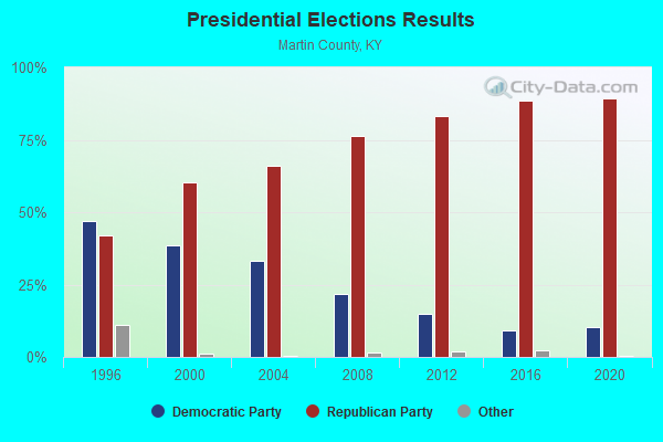
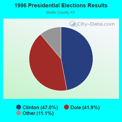
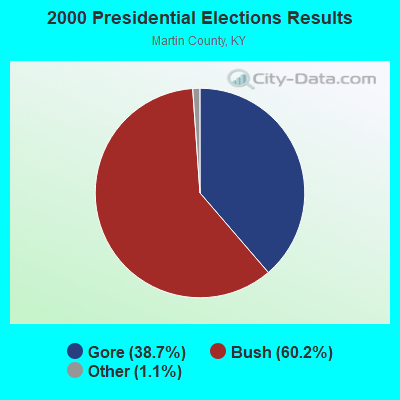
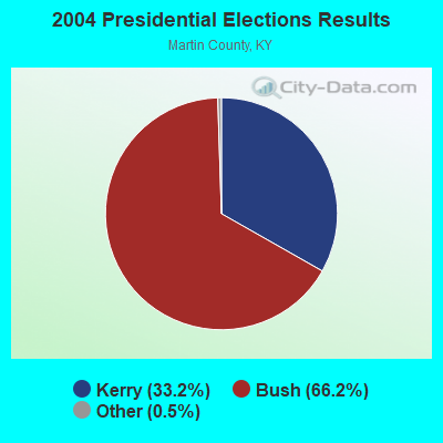
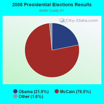

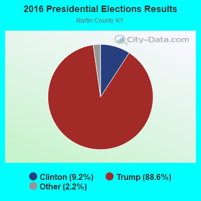
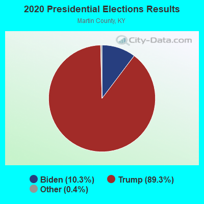
Graphs represent county-level data. Detailed 2008 Election Results
Religion statistics for Three Forks, KY (based on Martin County data)
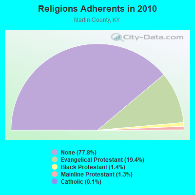
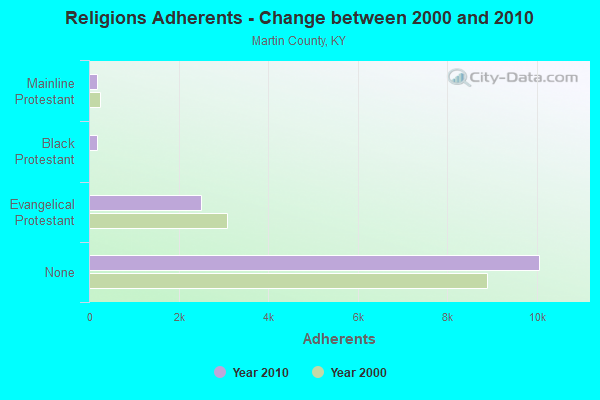
| Religion | Adherents | Congregations |
|---|---|---|
| Evangelical Protestant | 2,508 | 23 |
| Black Protestant | 179 | 1 |
| Mainline Protestant | 171 | 2 |
| Catholic | 13 | 1 |
| None | 10,058 | - |
Food Environment Statistics:
| Here: | 2.58 / 10,000 pop. |
| Kentucky: | 2.19 / 10,000 pop. |
| This county: | 1.72 / 10,000 pop. |
| Kentucky: | 0.74 / 10,000 pop. |
| Martin County: | 13.75 / 10,000 pop. |
| Kentucky: | 4.36 / 10,000 pop. |
| Martin County: | 3.44 / 10,000 pop. |
| State: | 5.74 / 10,000 pop. |
| Martin County: | 11.9% |
| Kentucky: | 11.0% |
| This county: | 36.0% |
| State: | 30.0% |
| Martin County: | 20.9% |
| Kentucky: | 15.9% |
Strongest AM radio stations in Three Forks:
- WKYH (600 AM; 5 kW; PAINTSVILLE, KY; Owner: HIGHLANDS BROADCASTING CORPORATION)
- WPRT (960 AM; 5 kW; PRESTONSBURG, KY; Owner: EAST KENTUCKY RADIO NETWORK, INC.)
- WBTH (1400 AM; 1 kW; WILLIAMSON, WV; Owner: EAST KENTUCKY RADIO NETWORK, INC.)
- WLSI (900 AM; 5 kW; PIKEVILLE, KY; Owner: EAST KENTUCKY BROADCASTING CORPORATION)
- WDOC (1310 AM; 5 kW; PRESTONSBURG, KY)
- WVOW (1290 AM; 5 kW; LOGAN, WV; Owner: LOGAN BROADCASTING CORPORATION)
- WTVN (610 AM; 50 kW; COLUMBUS, OH; Owner: CITICASTERS LICENSES, L.P.)
- WNRG (940 AM; 5 kW; GRUNDY, VA; Owner: VIRGINIA-KENTUCKY BROADCASTING CO., INC)
- WBPA (1460 AM; 5 kW; ELKHORN CITY, KY; Owner: EAST KENTUCKY BROADCASTING CORP)
- WCAW (680 AM; 10 kW; CHARLESTON, WV; Owner: WEST VIRGINIA RADIO CORPORATION OF CHARLESTON)
- WHJC (1360 AM; daytime; 1 kW; MATEWAN, WV)
- WVHU (800 AM; 5 kW; HUNTINGTON, WV; Owner: CAPSTAR TX LIMITED PARTNERSHIP)
- WLW (700 AM; 50 kW; CINCINNATI, OH; Owner: JACOR BROADCASTING CORPORATION)
Strongest FM radio stations in Three Forks:
- WXCC (96.5 FM; WILLIAMSON, WV; Owner: EAST KENTUCKY RADIO NETWORK, INC.)
- WXLR (104.9 FM; HAROLD, KY; Owner: ADAM D GEARHEART)
- WVKM (106.7 FM; MATEWAN, WV; Owner: THREE STATES BROADCASTING CO., INC.)
- WQHY (95.5 FM; PRESTONSBURG, KY; Owner: WDOC, INC.)
- WDHR (93.1 FM; PIKEVILLE, KY; Owner: EAST KENTUCKY BROADCASTING CORP.)
- WPKE-FM (103.1 FM; COAL RUN, KY; Owner: EAST KENTUCKY BROADCASTING CORP.)
- WKLW-FM (94.7 FM; PAINTSVILLE, KY; Owner: B & G BROADCASTING, INC.)
- WVOW-FM (101.9 FM; LOGAN, WV; Owner: LOGAN BROADCASTING CORP.)
- WZLK (107.5 FM; VIRGIE, KY; Owner: EAST KENTUCKY BROADCASTING CORPORATION)
- WSIP-FM (98.9 FM; PAINTSVILLE, KY; Owner: SIP BROADCASTING, INC.)
- WIFX-FM (94.3 FM; JENKINS, KY; Owner: LETCHER COUNTY BROADCASTING, INC)
- WMDJ-FM (100.1 FM; ALLEN, KY; Owner: FLOYD COUNTY BROADCASTING CO., INC.)
- WDXC (102.3 FM; POUND, VA; Owner: WDXC RADIO, INC.)
- WXKQ-FM (103.9 FM; WHITESBURG, KY; Owner: T.C.W. BROADCASTING , INC.)
- WMMT (88.7 FM; WHITESBURG, KY; Owner: APPALSHOP, INCORPORATED)
- WKLC-FM (105.1 FM; ST. ALBANS, WV; Owner: WKLC, INC.)
- WJSO (90.1 FM; PIKEVILLE, KY; Owner: THE MOODY BIBLE INSTITUTE OF CHICAGO)
- W251AI (98.1 FM; PIKEVILLE, KY; Owner: EAST KENTUCKY BROADCASTING CORPORATION)
- WXKZ-FM (105.3 FM; PRESTONSBURG, KY; Owner: ADAM GEARHEART D/B/A WXLR-FM)
TV broadcast stations around Three Forks:
- WVAH-TV (Channel 11; CHARLESTON, WV; Owner: WVAH LICENSEE, LLC)
- WCHS-TV (Channel 8; CHARLESTON, WV; Owner: WCHS LICENSEE, LLC)
- WPBY-TV (Channel 33; HUNTINGTON, WV; Owner: WEST VIRGINIA EDUCATIONAL BROADCASTING AUTHORITY)

- 55.2%Electricity
- 30.2%Utility gas
- 10.2%Bottled, tank, or LP gas
- 2.9%Fuel oil, kerosene, etc.
- 1.6%Wood

- 54.0%Utility gas
- 46.0%Electricity
Three Forks compared to Kentucky state average:
- Median household income below state average.
- Median house value below state average.
- Black race population percentage significantly below state average.
- Hispanic race population percentage significantly below state average.
- Median age below state average.
- Foreign-born population percentage significantly below state average.
- Renting percentage below state average.
- Length of stay since moving in significantly above state average.
- Number of rooms per house significantly below state average.
- House age significantly below state average.
- Number of college students below state average.
- Percentage of population with a bachelor's degree or higher significantly below state average.