The Rock-Yatesville, Georgia
Submit your own pictures of this place and show them to the world
- OSM Map
- Google Map
- MSN Map
| Males: 1,457 | |
| Females: 1,436 |
| Median resident age: | 37.7 years |
| Georgia median age: | 33.4 years |
Zip code: 30286
| The Rock-Yatesville: | $65,234 |
| GA: | $72,837 |
Estimated per capita income in 2022: $27,501 (it was $16,568 in 2000)
The Rock-Yatesville CCD income, earnings, and wages data
Estimated median house or condo value in 2022: $179,477 (it was $68,600 in 2000)
| The Rock-Yatesville: | $179,477 |
| GA: | $297,400 |
Mean prices in 2022: all housing units: $165,123; detached houses: $173,080; townhouses or other attached units: $211,782; mobile homes: $84,670
The Rock-Yatesville, GA residents, houses, and apartments details
Detailed information about poverty and poor residents in The Rock-Yatesville, GA
Compare current foreclosures near your location:
| Photo | Address | Area | Beds / Baths | Price | Details |
|---|---|---|---|---|---|

|
#1
S High St
Columbus, OH 43207
|
1,678 sq. feet
|
2 baths 4 beds |
$27,500
|
show details |

|
#2
Bayberry Cir
Columbus, OH 43207
|
1,564 sq. feet
|
1 baths 3 beds |
$127,500
|
show details |

|
#3
E 21st Ave
Columbus, OH 43211
|
1,061 sq. feet
|
1 baths 3 beds |
$179,900
|
show details |

|
#4
Hildreth Ave
Columbus, OH 43203
|
1,798 sq. feet
|
2 baths 4 beds |
show details | |

|
#5
Fairfield Ave
Columbus, OH 43203
|
984 sq. feet
|
1 baths 2 beds |
show details | |

|
#6
Executive Ct
Westerville, OH 43081
|
1,811 sq. feet
|
2 baths 3 beds |
show details | |

|
#7
N Roys Ave
Columbus, OH 43204
|
1,248 sq. feet
|
2 baths 3 beds |
show details | |

|
#8
Hiawatha Park Dr
Columbus, OH 43211
|
1,278 sq. feet
|
1 baths 4 beds |
show details | |

|
#9
Fergus Rd
Grove City, OH 43123
|
3,312 sq. feet
|
2 baths 4 beds |
show details | |

|
#10
Upton Rd E
Columbus, OH 43232
|
852 sq. feet
|
1 baths 3 beds |
show details |
| Photo | Address | Area | Beds / Baths | Price | Details |
|---|---|---|---|---|---|

|
#11
Cannonade Ct
Columbus, OH 43230
|
2,023 sq. feet
|
2 baths 3 beds |
show details | |

|
#12
E Howard Rd
Columbus, OH 43207
|
1,056 sq. feet
|
1 baths 3 beds |
show details | |

|
#13
S Champion Ave
Columbus, OH 43207
|
1,157 sq. feet
|
1 baths 2 beds |
show details | |

|
#14
E Welch Ave
Columbus, OH 43207
|
1,864 sq. feet
|
2 baths 4 beds |
show details | |

|
#15
Meadowbrook Dr
Columbus, OH 43207
|
1,752 sq. feet
|
2 baths 4 beds |
show details | |

|
#16
Chester Rd
Columbus, OH 43221
|
3,300 sq. feet
|
4 baths 5 beds |
show details | |

|
#17
Lehner Rd
Columbus, OH 43224
|
1,628 sq. feet
|
2 baths 4 beds |
show details | |

|
#18
Summertree Ln
Westerville, OH 43081
|
2,496 sq. feet
|
2 baths 3 beds |
show details | |

|
#19
Wrexham Ave
Columbus, OH 43223
|
1,235 sq. feet
|
1 baths 3 beds |
show details | |

|
#20
Chidley St
Galloway, OH 43119
|
1,502 sq. feet
|
1 baths 3 beds |
show details |
| Photo | Address | Area | Beds / Baths | Price | Details |
|---|---|---|---|---|---|

|
#21
N Roys Ave
Columbus, OH 43204
|
648 sq. feet
|
2 baths 3 beds |
show details | |

|
#22
Armada Rd
Columbus, OH 43232
|
1,028 sq. feet
|
1 baths 4 beds |
show details | |

|
#23
Glenmate Ct
Columbus, OH 43223
|
1,050 sq. feet
|
1 baths 3 beds |
show details | |

|
#24
E Lincoln Ave
Columbus, OH 43214
|
874 sq. feet
|
1 baths 3 beds |
show details | |

|
#25
London Groveport Rd
Grove City, OH 43123
|
816 sq. feet
|
1 baths 2 beds |
show details | |

|
#26
Ashgrove Dr
Grove City, OH 43123
|
1,772 sq. feet
|
2 baths 4 beds |
show details | |

|
#27
Hamilton Ave
Columbus, OH 43211
|
1,061 sq. feet
|
1 baths 3 beds |
show details | |

|
#28
Roundelay Rd N
Reynoldsburg, OH 43068
|
1,712 sq. feet
|
2 baths 3 beds |
show details | |

|
#29
Kelton Ave
Columbus, OH 43206
|
1,080 sq. feet
|
1 baths 3 beds |
show details | |

|
#30
Whittman Ct
Plain City, OH 43064
|
3,186 sq. feet
|
3 baths 4 beds |
show details |
| Photo | Address | Area | Beds / Baths | Price | Details |
|---|---|---|---|---|---|

|
#31
Striebel Ct
Columbus, OH 43227
|
925 sq. feet
|
1 baths 3 beds |
show details | |

|
#32
Grasmere Ave
Columbus, OH 43211
|
720 sq. feet
|
1 baths 2 beds |
show details | |

|
#33
N 18th St
Columbus, OH 43203
|
1,690 sq. feet
|
1 baths 4 beds |
show details | |

|
#34
S Richardson Ave
Columbus, OH 43204
|
1,520 sq. feet
|
2 baths 3 beds |
show details | |

|
#35
Rosewood Ct
Powell, OH 43065
|
2,801 sq. feet
|
3 baths 4 beds |
show details | |

|
#36
Gladys Rd
Columbus, OH 43228
|
832 sq. feet
|
1 baths 3 beds |
show details | |

|
#37
Plainview Dr
Columbus, OH 43204
|
730 sq. feet
|
1 baths 2 beds |
show details | |

|
#38
Falls Peak Ln
Delaware, OH 43015
|
1,352 sq. feet
|
2 baths 2 beds |
show details | |

|
#39
High Free Pike
West Jefferson, OH 43162
|
1,216 sq. feet
|
2 baths 4 beds |
show details | |

|
#40
Pegwood Dr
Columbus, OH 43229
|
878 sq. feet
|
1 baths 1 beds |
show details |
| Photo | Address | Area | Beds / Baths | Price | Details |
|---|---|---|---|---|---|

|
#41
Edgeview Rd
Columbus, OH 43207
|
1,352 sq. feet
|
1 baths 4 beds |
show details | |

|
#42
Grand Bend Dr
Groveport, OH 43125
|
1,612 sq. feet
|
1 baths 3 beds |
show details | |

|
#43
Blaine Dr
Columbus, OH 43227
|
1,294 sq. feet
|
1 baths 3 beds |
show details | |

|
#44
Lowery Dr
Columbus, OH 43231
|
1,557 sq. feet
|
2 baths 3 beds |
show details | |

|
#45
Sapphire Dr
Grove City, OH 43123
|
3,241 sq. feet
|
3 baths 4 beds |
show details | |

|
#46
Dinard Way
Columbus, OH 43221
|
1,647 sq. feet
|
2 baths 3 beds |
show details | |

|
#47
Eastrise Dr
Groveport, OH 43125
|
2,025 sq. feet
|
2 baths 3 beds |
show details | |

|
#48
Crocker Rd
Columbus, OH 43232
|
895 sq. feet
|
1 baths 3 beds |
show details | |

|
#49
Sundew Ave
Grove City, OH 43123
|
1,802 sq. feet
|
2 baths 3 beds |
show details | |

|
Check over 1 million property listings on Foreclosure.com!
|
browse all offers | |||

- 2,40382.8%White alone
- 44315.3%Black alone
- 341.2%Hispanic
- 110.4%Two or more races
- 50.2%American Indian alone
- 50.2%Asian alone

Races in The Rock-Yatesville detailed stats: ancestries, foreign born residents, place of birth
 Recent articles from our blog. Our writers, many of them Ph.D. graduates or candidates, create easy-to-read articles on a wide variety of topics.
Current Local Time: EST time zone
Land area: 88.4 square miles.
Population density: 33 people per square mile (very low).
| The Rock-Yatesville CCD: | 0.8% ($532) |
| Georgia: | 0.9% ($919) |
Nearest city with pop. 50,000+: Macon, GA  (34.0 miles , pop. 97,255).
Nearest city with pop. 200,000+: Atlanta, GA (58.3 miles , pop. 416,474).
Nearest city with pop. 1,000,000+: Chicago, IL (644.8 miles , pop. 2,896,016).
Nearest cities:
), Latitude: 32.93 N, Longitude: 84.21 W

| Here: | 2.9% |
| Georgia: | 2.9% |

- Construction (11.5%)
- Health care (8.5%)
- Public administration (6.3%)
- Textile mills & textile products (5.0%)
- Educational services (4.8%)
- Agriculture, forestry, fishing & hunting (4.5%)
- Food & beverage stores (3.6%)

- Construction (19.5%)
- Agriculture, forestry, fishing & hunting (6.6%)
- Public administration (6.5%)
- Textile mills & textile products (4.9%)
- Food & beverage stores (4.2%)
- Truck transportation (3.8%)
- Printing & related support activities (3.6%)

- Health care (16.1%)
- Educational services (10.0%)
- Accommodation & food services (6.3%)
- Public administration (6.0%)
- Textile mills & textile products (5.1%)
- Finance & insurance (3.7%)
- Miscellaneous manufacturing (3.5%)

- Other production occupations, including supervisors (7.7%)
- Electrical equipment mechanics and other installation, maintenance, and repair workers, including supervisors (4.5%)
- Driver/sales workers and truck drivers (4.3%)
- Material recording, scheduling, dispatching, and distributing workers (3.7%)
- Assemblers and fabricators (3.4%)
- Other office and administrative support workers, including supervisors (3.3%)
- Secretaries and administrative assistants (3.2%)

- Electrical equipment mechanics and other installation, maintenance, and repair workers, including supervisors (7.9%)
- Other production occupations, including supervisors (7.7%)
- Driver/sales workers and truck drivers (7.7%)
- Construction laborers (5.1%)
- Material recording, scheduling, dispatching, and distributing workers (4.0%)
- Pipelayers, plumbers, pipefitters, and steamfitters (3.9%)
- Vehicle and mobile equipment mechanics, installers, and repairers (3.9%)

- Other production occupations, including supervisors (7.6%)
- Secretaries and administrative assistants (7.0%)
- Other teachers, instructors, education, training, and library occupations (6.3%)
- Other office and administrative support workers, including supervisors (6.3%)
- Bookkeeping, accounting, and auditing clerks (5.0%)
- Health technologists and technicians (4.7%)
- Other sales and related occupations, including supervisors (4.2%)
Average climate in The Rock-Yatesville, Georgia
Based on data reported by over 4,000 weather stations


Tornado activity:
The Rock-Yatesville-area historical tornado activity is near Georgia state average. It is 33% greater than the overall U.S. average.
On 12/25/1964, a category F3 (max. wind speeds 158-206 mph) tornado 19.0 miles away from the The Rock-Yatesville place center killed 2 people and injured 16 people and caused between $500,000 and $5,000,000 in damages.
On 1/2/2006, a category F3 tornado 20.6 miles away from the place center injured 3 people and caused $1 million in damages.
Earthquake activity:
The Rock-Yatesville-area historical earthquake activity is significantly above Georgia state average. It is 26% greater than the overall U.S. average.On 8/2/1974 at 08:52:09, a magnitude 4.9 (4.3 MB, 4.9 LG, Class: Light, Intensity: IV - V) earthquake occurred 118.6 miles away from The Rock-Yatesville center
On 4/29/2003 at 08:59:39, a magnitude 4.9 (4.4 MB, 4.6 MW, 4.9 LG) earthquake occurred 135.5 miles away from The Rock-Yatesville center
On 4/29/2003 at 08:59:39, a magnitude 4.6 (4.6 MW, Depth: 12.3 mi) earthquake occurred 135.5 miles away from The Rock-Yatesville center
On 1/18/1999 at 07:00:53, a magnitude 4.8 (4.8 MB, 4.0 LG, Depth: 0.6 mi) earthquake occurred 179.5 miles away from The Rock-Yatesville center
On 10/24/1997 at 08:35:17, a magnitude 4.9 (4.8 MB, 4.2 MS, 4.9 LG, Depth: 6.2 mi) earthquake occurred 219.0 miles away from the city center
On 11/30/1973 at 07:48:41, a magnitude 4.7 (4.7 MB, 4.6 ML) earthquake occurred 198.7 miles away from The Rock-Yatesville center
Magnitude types: regional Lg-wave magnitude (LG), body-wave magnitude (MB), local magnitude (ML), surface-wave magnitude (MS), moment magnitude (MW)
Natural disasters:
The number of natural disasters in Upson County (16) is near the US average (15).Major Disasters (Presidential) Declared: 10
Emergencies Declared: 4
Causes of natural disasters: Floods: 5, Storms: 5, Tornadoes: 5, Winter Storms: 4, Hurricanes: 3, Winds: 3, Tropical Storms: 2, Drought: 1, Heavy Rain: 1, Snowfall: 1, Other: 1 (Note: some incidents may be assigned to more than one category).
Hospitals and medical centers near The Rock-Yatesville:
- GOLDEN LIVINGCENTER - THOMASTON (Nursing Home, about 7 miles away; THOMASTON, GA)
- PROVIDENCE HEALTH AND REHABILITATION CENTER INC (Nursing Home, about 8 miles away; THOMASTON, GA)
- PROVIDENCE HEALTH CARE (Nursing Home, about 8 miles away; THOMASTON, GA)
- THOMASTON HOSPICE, INC (Hospital, about 8 miles away; THOMASTON, GA)
- UPSON REGIONAL MEDICAL CENTER Acute Care Hospitals (about 9 miles away; THOMASTON, GA)
- RIVERSIDE HEALTH AND REHABILITATION (Nursing Home, about 9 miles away; THOMASTON, GA)
- RIVERSIDE NURSING CTR OF THOMASTON (Nursing Home, about 9 miles away; THOMASTON, GA)
Colleges/universities with over 2000 students nearest to The Rock-Yatesville:
- Gordon State College (about 9 miles; Barnesville, GA; Full-time enrollment: 3,336)
- Southern Crescent Technical College (about 23 miles; Griffin, GA; FT enrollment: 4,168)
- Middle Georgia State College (about 29 miles; Macon, GA; FT enrollment: 7,091)
- Fort Valley State University (about 33 miles; Fort Valley, GA; FT enrollment: 3,200)
- Mercer University (about 34 miles; Macon, GA; FT enrollment: 6,297)
- Central Georgia Technical College (about 42 miles; Warner Robins, GA; FT enrollment: 6,829)
- Clayton State University (about 47 miles; Morrow, GA; FT enrollment: 5,844)
Points of interest:
Notable locations in The Rock-Yatesville: Rock Hill Volunteer Fire Department Station 1 (A), Georgia Greenhouses (B), Yatesville Fire Department (C), Rock Hill Volunteer Fire Department Station 2 (D). Display/hide their locations on the map
Churches in The Rock-Yatesville include: Grays Chapel (A), Andrews Chapel (B), Bethany Church (C), Calvary Church (D), Liberty Chapel (E), Mount Olive Church (F), Mount Zion Church (G), New Hope Church (H), Pine Grove Church (I). Display/hide their locations on the map
Cemeteries: Arnold Cemetery (1), Salem Cemetery (2), Sandy Grove Cemetery (3), Andrews Chapel Cemetery (4), Antioch Cemetery (5), Bethany Cemetery (6), Bethlehem Cemetery (7). Display/hide their locations on the map
Reservoirs: Binford Lake (A), Haygood Lake (B), Lake Julia (C), Lake Maude (D), Trice Lake (E), Triple S Lake (F), Nash Lake (G), McGehee Lake (H). Display/hide their locations on the map
Streams, rivers, and creeks: Weatherford Branch (A), Threemile Creek (B), Sullivan Creek (C), Israel Creek (D), Rose Creek (E), Fourth Branch (F), Bunkley Woods Branch (G), Kendall Branch (H). Display/hide their locations on the map
| This place: | 2.6 people |
| Georgia: | 2.6 people |
| This place: | 73.4% |
| Whole state: | 68.5% |
| This place: | 5.9% |
| Whole state: | 5.9% |
Likely homosexual households (counted as self-reported same-sex unmarried-partner households)
- Lesbian couples: 0.2% of all households
- Gay men: 0.6% of all households
| This place: | 7.3% |
| Whole state: | 13.0% |
| This place: | 3.8% |
| Whole state: | 6.1% |
For population 15 years and over in The Rock-Yatesville:

- Never married: 19.7%
- Now married: 63.4%
- Separated: 0.7%
- Widowed: 6.4%
- Divorced: 10.6%
For population 25 years and over in The Rock-Yatesville:
- High school or higher: 70.7%
- Bachelor's degree or higher: 8.8%
- Graduate or professional degree: 2.6%
- Unemployed: 2.7%
- Mean travel time to work (commute): 28.9 minutes


| Here: | 12.7 |
| Georgia average: | 13.3 |
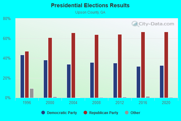
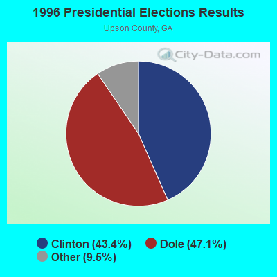
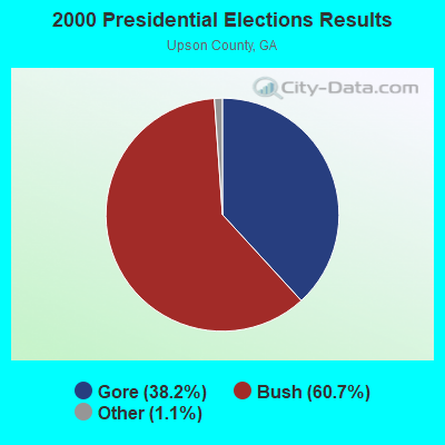


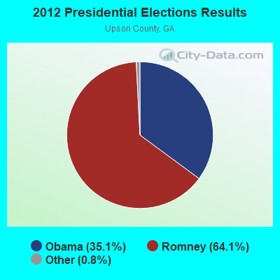


Graphs represent county-level data. Detailed 2008 Election Results
Religion statistics for The Rock-Yatesville, GA (based on Upson County data)
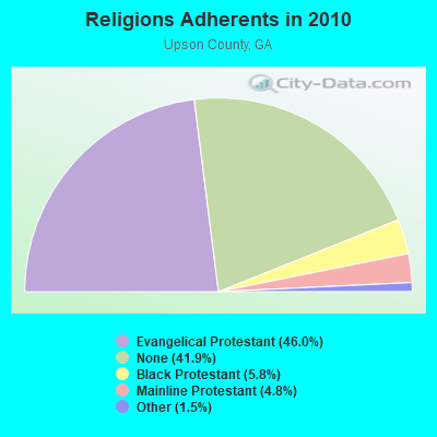
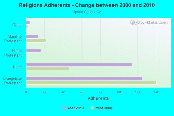
| Religion | Adherents | Congregations |
|---|---|---|
| Evangelical Protestant | 12,490 | 40 |
| Black Protestant | 1,581 | 8 |
| Mainline Protestant | 1,305 | 10 |
| Other | 413 | 2 |
| Catholic | - | - |
| None | 11,364 | - |
Food Environment Statistics:
| Upson County: | 2.90 / 10,000 pop. |
| Georgia: | 1.91 / 10,000 pop. |
| Here: | 0.36 / 10,000 pop. |
| Georgia: | 0.15 / 10,000 pop. |
| Upson County: | 1.09 / 10,000 pop. |
| State: | 0.86 / 10,000 pop. |
| This county: | 5.08 / 10,000 pop. |
| State: | 5.12 / 10,000 pop. |
| This county: | 8.70 / 10,000 pop. |
| Georgia: | 7.41 / 10,000 pop. |
| This county: | 11.9% |
| Georgia: | 10.4% |
| This county: | 31.0% |
| Georgia: | 27.8% |
| Upson County: | 13.1% |
| State: | 14.6% |
Strongest AM radio stations in The Rock-Yatesville:
- WMAC (940 AM; 50 kW; MACON, GA; Owner: CUMULUS LICENSING CORP.)
- WGST (640 AM; 50 kW; ATLANTA, GA; Owner: CITICASTERS LICENSES, L.P.)
- WGUN (1010 AM; 50 kW; ATLANTA, GA; Owner: WGUN, INC.)
- WSB (750 AM; 50 kW; ATLANTA, GA; Owner: CXR HOLDINGS, INC.)
- WCNN (680 AM; 50 kW; NORTH ATLANTA, GA; Owner: DICKEY BROADCASTING COMPANY)
- WBAF (1090 AM; daytime; 1 kW; BARNESVILLE, GA; Owner: BARNESVILLE BROADCASTING, INC.)
- WAOK (1380 AM; 50 kW; ATLANTA, GA; Owner: INFINITY BROADCASTING OPERATIONS, INC.)
- WMLB (1160 AM; 50 kW; EAST POINT, GA; Owner: ATLANTA AREA BROADCASTING, INC.)
- WQXI (790 AM; 28 kW; ATLANTA, GA; Owner: JEFFERSON-PILOT COMMUNICATIONS COMPANY OF GEORGIA)
- WTGA (1590 AM; 0 kW; THOMASTON, GA; Owner: RADIO GEORGIA, INC.)
- WHIE (1320 AM; 5 kW; GRIFFIN, GA; Owner: CHAPPELL COMMUNICATIONS, LLC)
- WNNG (1350 AM; 15 kW; WARNER ROBINS, GA; Owner: CHASE BROADCASTING, INC.)
- WFTD (1080 AM; daytime; 50 kW; MARIETTA, GA; Owner: PRIETO ENTERPRISES, INC.)
Strongest FM radio stations in The Rock-Yatesville:
- WKEU-FM (88.9 FM; THE ROCK, GA; Owner: GEORGIA FOUNDATION OF PUBLIC BROADCASTING, INC.)
- WVFJ-FM (93.3 FM; MANCHESTER, GA; Owner: PROVIDENT BROADCASTING COMPANY)
- WTGA-FM (101.1 FM; THOMASTON, GA; Owner: RADIO GEORGIA, INC.)
- WEKS (92.5 FM; ZEBULON, GA; Owner: SPALDING BROADCASTING, INC.)
- WJSP-FM (88.1 FM; WARM SPRINGS, GA; Owner: GEORGIA PUBLIC TELECOMMUNICATIONS COMMISSION)
- WQMJ (100.1 FM; FORSYTH, GA; Owner: ROBERTS COMMUNICATIONS, INC.)
- WKZJ (95.7 FM; GREENVILLE, GA; Owner: DAVIS B/CASTING OF COLUMBUS, INC)
- WYNF (96.5 FM; GRAY, GA; Owner: CLEVELAND RADIO LICENSES, LLC)
- WJTG (91.3 FM; FORT VALLEY, GA; Owner: JOY PUBLIC B/CNG CORP)
- WQBZ (106.3 FM; FORT VALLEY, GA; Owner: CLEVELAND RADIO LICENSES, LLC)
- WCRU-LP (97.1 FM; THOMASTON, GA; Owner: THOMASTON CHRISTIAN RADIO)
TV broadcast stations around The Rock-Yatesville:
- WJSP-TV (Channel 28; COLUMBUS, GA; Owner: GEORGIA PUBLIC TELECOMMUNICATIONS COMMISSION)
- WTVM (Channel 9; COLUMBUS, GA; Owner: RAYCOM AMERICA, INC.)
- WDMA-LP (Channel 32; MACON, GA; Owner: WORD OF GOD FELLOWSHIP, INC.)
- WPGA-TV (Channel 58; PERRY, GA; Owner: RADIO PERRY, INC.)
- WMGT-TV (Channel 41; MACON, GA; Owner: MORRIS NETWORK, INC.)
- WMAZ-TV (Channel 13; MACON, GA; Owner: GANNETT GEORGIA, L.P.)
- WGXA (Channel 24; MACON, GA; Owner: PIEDMONT TELEVISION OF MACON LICENSE LLC)

- 58.7%Bottled, tank, or LP gas
- 35.2%Electricity
- 3.6%Utility gas
- 1.8%Wood
- 0.8%No fuel used

- 83.1%Bottled, tank, or LP gas
- 7.5%Electricity
- 7.5%Wood
- 1.9%Other fuel
The Rock-Yatesville compared to Georgia state average:
- Median house value below state average.
- Unemployed percentage significantly below state average.
- Black race population percentage below state average.
- Hispanic race population percentage significantly below state average.
- Foreign-born population percentage significantly below state average.
- Renting percentage below state average.
- Length of stay since moving in significantly above state average.
- Number of rooms per house significantly below state average.
- House age significantly below state average.
- Percentage of population with a bachelor's degree or higher significantly below state average.