Tejay, Kentucky
Submit your own pictures of this place and show them to the world
- OSM Map
- General Map
- Google Map
- MSN Map

| Males: 922 | |
| Females: 912 |
| Median resident age: | 36.3 years |
| Kentucky median age: | 35.9 years |
Zip code: 40845
| Tejay: | $33,051 |
| KY: | $59,341 |
Estimated per capita income in 2022: $24,816 (it was $14,646 in 2000)
Tejay CCD income, earnings, and wages data
Estimated median house or condo value in 2022: $84,451 (it was $41,400 in 2000)
| Tejay: | $84,451 |
| KY: | $196,300 |
Mean prices in 2022: all housing units: $126,319; detached houses: $148,633; townhouses or other attached units: $90,266; in 2-unit structures: $102,201; in 3-to-4-unit structures: $378,810; mobile homes: $61,459
Detailed information about poverty and poor residents in Tejay, KY


- 1,87198.5%White alone
- 120.6%Hispanic
- 80.4%Two or more races
- 60.3%American Indian alone
- 10.05%Black alone
- 10.05%Asian alone

Races in Tejay detailed stats: ancestries, foreign born residents, place of birth
 Recent articles from our blog. Our writers, many of them Ph.D. graduates or candidates, create easy-to-read articles on a wide variety of topics.
Current Local Time: EST time zone
Elevation: 1040 feet
Land area: 48.5 square miles.
Population density: 38 people per square mile (very low).

| Tejay CCD: | 0.6% ($264) |
| Kentucky: | 0.8% ($610) |
Nearest city with pop. 50,000+: Knoxville, TN  (59.4 miles , pop. 173,890).
Nearest city with pop. 200,000+: Fayette, KY (102.3 miles , pop. 260,512).
Nearest city with pop. 1,000,000+: Chicago, IL (415.3 miles , pop. 2,896,016).
Nearest cities:
), ), ), ), ), )Latitude: 36.76 N, Longitude: 83.53 W
Area code commonly used in this area: 606


| Here: | 5.3% |
| Kentucky: | 3.8% |

- Health care (13.4%)
- Educational services (9.8%)
- Mining, quarrying, oil & gas extraction (9.8%)
- Furniture & related product manufacturing (7.0%)
- Public administration (6.2%)
- Construction (5.2%)
- Apparel (4.8%)

- Mining, quarrying, oil & gas extraction (17.9%)
- Furniture & related product manufacturing (9.7%)
- Construction (9.4%)
- Truck transportation (8.4%)
- Health care (6.8%)
- Transportation equipment (6.2%)
- Educational services (5.5%)

- Health care (21.3%)
- Educational services (15.0%)
- Apparel (10.7%)
- Public administration (9.1%)
- Accommodation & food services (7.9%)
- Food & beverage stores (4.7%)
- Printing & related support activities (4.3%)

- Preschool, kindergarten, elementary, and middle school teachers (7.5%)
- Building and grounds cleaning and maintenance occupations (6.8%)
- Health technologists and technicians (5.7%)
- Driver/sales workers and truck drivers (5.5%)
- Other production occupations, including supervisors (4.6%)
- Assemblers and fabricators (4.3%)
- Construction traders workers except carpenters, electricians, painters, plumbers, and construction laborers (4.3%)

- Building and grounds cleaning and maintenance occupations (10.4%)
- Driver/sales workers and truck drivers (10.1%)
- Construction traders workers except carpenters, electricians, painters, plumbers, and construction laborers (7.8%)
- Assemblers and fabricators (7.8%)
- Laborers and material movers, hand (6.8%)
- Extraction workers (6.2%)
- Electrical equipment mechanics and other installation, maintenance, and repair workers, including supervisors (5.2%)

- Preschool, kindergarten, elementary, and middle school teachers (12.6%)
- Textile, apparel, and furnishings workers (9.1%)
- Nursing, psychiatric, and home health aides (8.3%)
- Other production occupations, including supervisors (8.3%)
- Health technologists and technicians (7.1%)
- Cooks and food preparation workers (6.7%)
- Art and design workers (5.1%)
Average climate in Tejay, Kentucky
Based on data reported by over 4,000 weather stations


(lower is better)

Air Quality Index (AQI) level in 2022 was 72.3. This is about average.
| City: | 72.3 |
| U.S.: | 72.6 |

Carbon Monoxide (CO) [ppm] level in 2000 was 0.127. This is significantly better than average. Closest monitor was 15.0 miles away from the city center.
| City: | 0.127 |
| U.S.: | 0.251 |

Ozone [ppb] level in 2022 was 27.8. This is about average. Closest monitor was 6.4 miles away from the city center.
| City: | 27.8 |
| U.S.: | 33.3 |

Particulate Matter (PM2.5) [µg/m3] level in 2022 was 9.68. This is about average. Closest monitor was 15.8 miles away from the city center.
| City: | 9.68 |
| U.S.: | 8.11 |
Tornado activity:
Tejay-area historical tornado activity is significantly below Kentucky state average. It is 49% smaller than the overall U.S. average.
On 5/9/1988, a category F3 (max. wind speeds 158-206 mph) tornado 13.2 miles away from the Tejay place center killed one person and injured 15 people and caused between $5,000,000 and $50,000,000 in damages.
On 3/12/1967, a category F3 tornado 33.4 miles away from the place center .
Earthquake activity:
Tejay-area historical earthquake activity is significantly above Kentucky state average. It is 58% greater than the overall U.S. average.On 7/27/1980 at 18:52:21, a magnitude 5.2 (5.1 MB, 4.7 MS, 5.0 UK, 5.2 UK, Class: Moderate, Intensity: VI - VII) earthquake occurred 102.2 miles away from Tejay center
On 8/9/2020 at 12:07:37, a magnitude 5.1 (5.1 MW, Depth: 4.7 mi) earthquake occurred 136.7 miles away from Tejay center
On 11/30/1973 at 07:48:41, a magnitude 4.7 (4.7 MB, 4.6 ML, Class: Light, Intensity: IV - V) earthquake occurred 71.0 miles away from the city center
On 8/23/2011 at 17:51:04, a magnitude 5.8 (5.8 MW, Depth: 3.7 mi) earthquake occurred 317.5 miles away from Tejay center
On 9/7/1988 at 02:28:09, a magnitude 4.6 (4.5 MB, 4.6 LG) earthquake occurred 97.2 miles away from the city center
On 4/18/2008 at 09:36:59, a magnitude 5.4 (5.1 MB, 4.8 MS, 5.4 MW, 5.2 MW) earthquake occurred 265.7 miles away from Tejay center
Magnitude types: regional Lg-wave magnitude (LG), body-wave magnitude (MB), local magnitude (ML), surface-wave magnitude (MS), moment magnitude (MW)
Natural disasters:
The number of natural disasters in Bell County (21) is greater than the US average (15).Major Disasters (Presidential) Declared: 14
Emergencies Declared: 2
Causes of natural disasters: Floods: 14, Storms: 12, Mudslides: 5, Landslides: 4, Tornadoes: 4, Fires: 2, Snows: 2, Winds: 2, Winter Storms: 2, Blizzard: 1, Freeze: 1, Hurricane: 1, Snowfall: 1, Snowstorm: 1, Other: 1 (Note: some incidents may be assigned to more than one category).
Hospitals and medical centers near Tejay:
- PINEVILLE COMMUNITY HOSPITAL Acute Care Hospitals (about 10 miles away; PINEVILLE, KY)
- TRI STATE HEALTH AND REHABILITATION CENTER (Nursing Home, about 15 miles away; HARROGATE, TN)
- AMEDISYS HOME HEALTH CARE (Home Health Center, about 15 miles away; MIDDLESBORO, KY)
- MIDDLESBORO ARH HOME HEALTH AGENCY (Home Health Center, about 15 miles away; MIDDLESBORO, KY)
Colleges/universities with over 2000 students nearest to Tejay:
- Lincoln Memorial University (about 15 miles; Harrogate, TN; Full-time enrollment: 3,706)
- Southeast Kentucky Community and Technical College (about 33 miles; Cumberland, KY; FT enrollment: 2,196)
- University of the Cumberlands (about 36 miles; Williamsburg, KY; FT enrollment: 3,585)
- Hazard Community and Technical College (about 38 miles; Hazard, KY; FT enrollment: 2,087)
- Walters State Community College (about 41 miles; Morristown, TN; FT enrollment: 4,359)
- Tusculum College (about 60 miles; Greeneville, TN; FT enrollment: 2,070)
- The University of Tennessee-Knoxville (about 61 miles; Knoxville, TN; FT enrollment: 25,483)
Points of interest:
Notable locations in Tejay: Martins Fork Campsite (A), Bell County Volunteer Fire Department Calloway Station (B). Display/hide their locations on the map
Churches in Tejay include: Whipple Church (A), Missionary Church (B), Oakdale Church (C), Bible Church (D), Upland Church (E). Display/hide their locations on the map
Cemeteries: Hall Cemetery (1), Wilson Cemetery (2), Miracle Cemetery (3), Hensley Cemetery (4), Balkan Cemetery (5), Tacket Hill Cemetery (6), Jackson Cemetery (7). Display/hide their locations on the map
Streams, rivers, and creeks: Dry Branch (A), Betsie Branch (B), Blacklick Branch (C), Yellow Cliff Branch (D), Watts Creek (E), Cy Hoskins Branch (F), Cubage Creek (G), Crooked Branch (H), Cowans Branch (I). Display/hide their locations on the map
| This place: | 2.5 people |
| Kentucky: | 2.5 people |
| This place: | 73.9% |
| Whole state: | 66.9% |
| This place: | 4.5% |
| Whole state: | 6.4% |
Likely homosexual households (counted as self-reported same-sex unmarried-partner households)
- Lesbian couples: 0.4% of all households
- Gay men: 1.1% of all households
| This place: | 27.8% |
| Whole state: | 15.8% |
| This place: | 6.9% |
| Whole state: | 6.6% |
For population 15 years and over in Tejay:

- Never married: 19.5%
- Now married: 61.0%
- Separated: 1.7%
- Widowed: 9.2%
- Divorced: 10.3%
For population 25 years and over in Tejay:
- High school or higher: 59.0%
- Bachelor's degree or higher: 10.0%
- Graduate or professional degree: 4.2%
- Unemployed: 6.2%
- Mean travel time to work (commute): 39.4 minutes


| Here: | 18.9 |
| Kentucky average: | 13.8 |
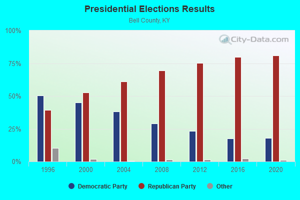
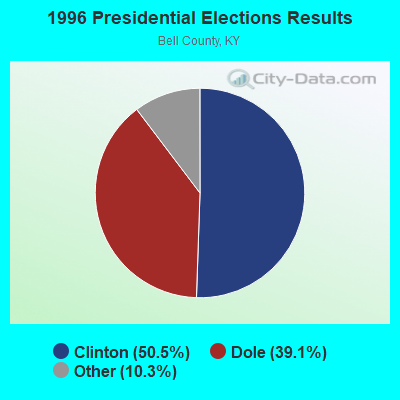
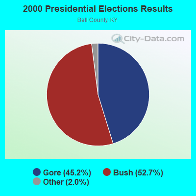
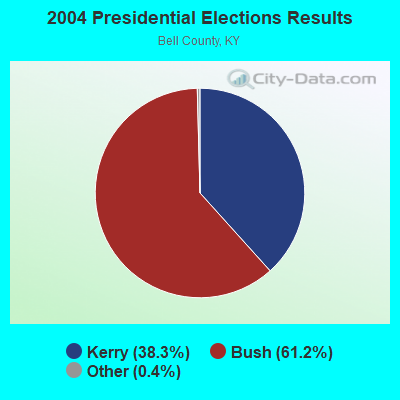
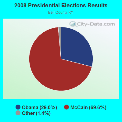
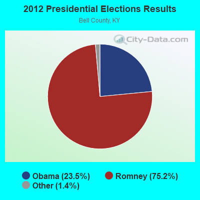
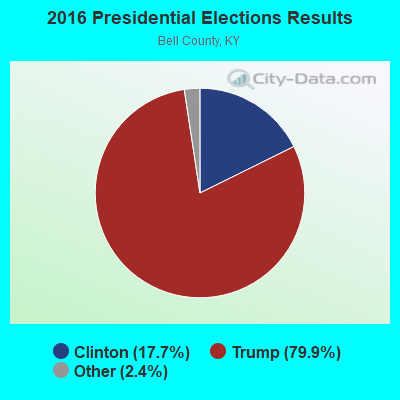
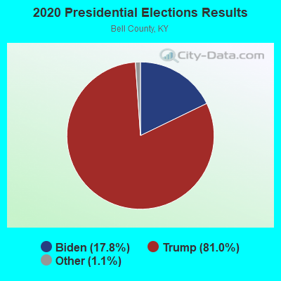
Graphs represent county-level data. Detailed 2008 Election Results
Religion statistics for Tejay, KY (based on Bell County data)
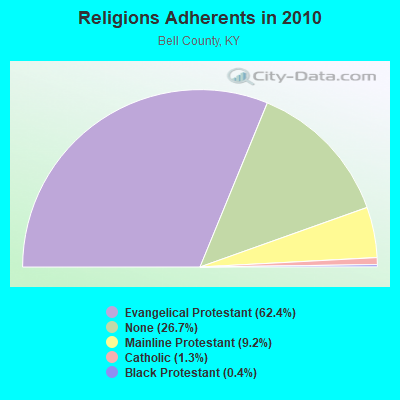
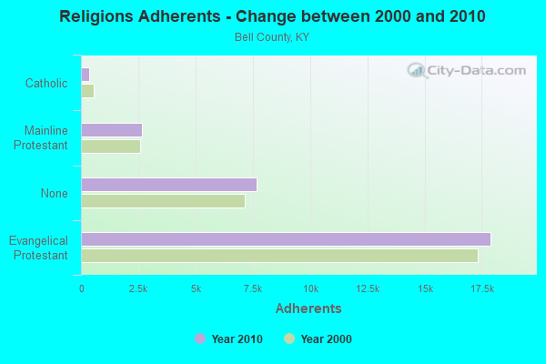
| Religion | Adherents | Congregations |
|---|---|---|
| Evangelical Protestant | 17,897 | 64 |
| Mainline Protestant | 2,651 | 12 |
| Catholic | 372 | 2 |
| Black Protestant | 119 | 1 |
| Other | 2 | - |
| None | 7,650 | - |
Food Environment Statistics:
| Bell County: | 4.14 / 10,000 pop. |
| Kentucky: | 2.19 / 10,000 pop. |
| This county: | 0.34 / 10,000 pop. |
| Kentucky: | 0.25 / 10,000 pop. |
| Bell County: | 2.41 / 10,000 pop. |
| Kentucky: | 4.36 / 10,000 pop. |
| Bell County: | 3.45 / 10,000 pop. |
| Kentucky: | 5.74 / 10,000 pop. |
| This county: | 13.5% |
| Kentucky: | 11.0% |
| Here: | 34.2% |
| State: | 30.0% |
| This county: | 19.4% |
| State: | 15.9% |
Strongest AM radio stations in Tejay:
- WHLN (1410 AM; 5 kW; HARLAN, KY)
- WFSR (970 AM; 5 kW; HARLAN, KY; Owner: EASTERN BROADCASTING COMPAY)
- WMIK (560 AM; 2 kW; MIDDLESBORO, KY; Owner: GATEWAY BROADCASTING, INC.)
- WKVL (850 AM; daytime; 50 kW; KNOXVILLE, TN; Owner: HORNE RADIO, LLC)
- WANO (1230 AM; 1 kW; PINEVILLE, KY; Owner: CUMBERLAND MEDIA GROUP, INC.)
- WRWB (740 AM; 1 kW; HARROGATE, TN; Owner: PINE HILLS OF TENNESSEE, INC.)
- WKLB (1290 AM; 5 kW; MANCHESTER, KY; Owner: BARKER BROADCASTING COMPANY, INC.)
- WFGW (1010 AM; 50 kW; BLACK MOUNTAIN, NC; Owner: BLUE RIDGE BROADCASTING CORP.)
- WEKC (710 AM; daytime; 4 kW; WILLIAMSBURG, KY; Owner: GERALD PARKS)
- WGOC (640 AM; 10 kW; BLOUNTVILLE, TN; Owner: CITADEL BROADCASTING COMPANY)
- WKDP (1330 AM; 5 kW; CORBIN, KY; Owner: EUBANKS BROADCASTING, INC.)
- WLFJ (660 AM; daytime; 50 kW; GREENVILLE, SC; Owner: CLEAR CHANNEL BROADCASTING LICENSES, INC.)
- WNOX (990 AM; 10 kW; KNOXVILLE, TN)
Strongest FM radio stations in Tejay:
- WRIL (106.3 FM; PINEVILLE, KY; Owner: PINE HILLS BROADCASTING, INC.)
- WMIK-FM (92.7 FM; MIDDLESBORO, KY; Owner: GATEWAY BROADCASTING, INC.)
- WTUK (105.1 FM; HARLAN, KY; Owner: EASTERN BROADCASTING COMPANY)
- WCTU (105.9 FM; TAZEWELL, TN; Owner: STAIR COMPANY, INC)
- WSEH (102.7 FM; CUMBERLAND, KY; Owner: CUMBERLAND CITY BROADCASTING, INC.)
- WAXM (93.5 FM; BIG STONE GAP, VA; Owner: VALLEY BROADCASTING, INC.)
- WJDT (106.5 FM; ROGERSVILLE, TN; Owner: C & S BROADCASTING)
- WSGS (101.1 FM; HAZARD, KY; Owner: MOUNTAIN BROADCASTING SERVICE, INC.)
- WBGQ (100.7 FM; BULLS GAP, TN; Owner: CHEROKEE BROADCASTING)
- WIMZ-FM (103.5 FM; KNOXVILLE, TN; Owner: SOUTH CENTRAL COMM., CORP.)
- WTFM (98.5 FM; KINGSPORT, TN; Owner: HOLSTON VALLEY BROADCASTING CORP.)
- WXJB (96.5 FM; HARROGATE, TN; Owner: JBD INCORPORATED)
- W223AA (92.5 FM; BIG STONE GAP, VA; Owner: VALLEY BROADCASTING, INC.)
- WDVX (89.9 FM; CLINTON, TN; Owner: CUMBERLAND COMMUNITIES COMMUNI CORP.)
- WEKH (90.9 FM; HAZARD, KY; Owner: EASTERN KENTUCKY UNIVERSITY)
- WZQQ (97.9 FM; HYDEN, KY; Owner: LESLIE COUNTY BROADCASTING, INC.)
- WJMD (104.7 FM; HAZARD, KY; Owner: HAZARD BROADCASTING SERVICES)
- WIFX-FM (94.3 FM; JENKINS, KY; Owner: LETCHER COUNTY BROADCASTING, INC)
- WOKI-FM (100.3 FM; OAK RIDGE, TN; Owner: OAK RIDGE FM, INC.)
- WKDP-FM (99.5 FM; CORBIN, KY; Owner: EUBANKS BROADCASTING, INC.)
TV broadcast stations around Tejay:
- WAGV (Channel 44; HARLAN, KY; Owner: LIVING FAITH MINISTRIES, INC.)
- WYMT-TV (Channel 57; HAZARD, KY; Owner: WYMT LICENSEE CORP.)
- W24BT (Channel 24; TALBERT, KY; Owner: MS COMMUNICATIONS, LLC)

- 72.7%Electricity
- 8.6%Coal or coke
- 6.9%Wood
- 6.0%Fuel oil, kerosene, etc.
- 4.8%Bottled, tank, or LP gas
- 1.0%Utility gas

- 60.2%Electricity
- 19.4%Fuel oil, kerosene, etc.
- 12.0%Coal or coke
- 8.3%Wood
Tejay compared to Kentucky state average:
- Median household income below state average.
- Median house value significantly below state average.
- Unemployed percentage below state average.
- Black race population percentage significantly below state average.
- Hispanic race population percentage significantly below state average.
- Median age below state average.
- Foreign-born population percentage significantly below state average.
- Renting percentage below state average.
- Length of stay since moving in significantly above state average.
- Number of rooms per house significantly below state average.
- House age significantly below state average.
- Percentage of population with a bachelor's degree or higher below state average.