Sweetwater, Arizona
Submit your own pictures of this place and show them to the world
- OSM Map
- General Map
- Google Map
- MSN Map

| Males: 2,788 | |
| Females: 2,849 |
| Median resident age: | 25.9 years |
| Arizona median age: | 34.2 years |
Zip code: 86514
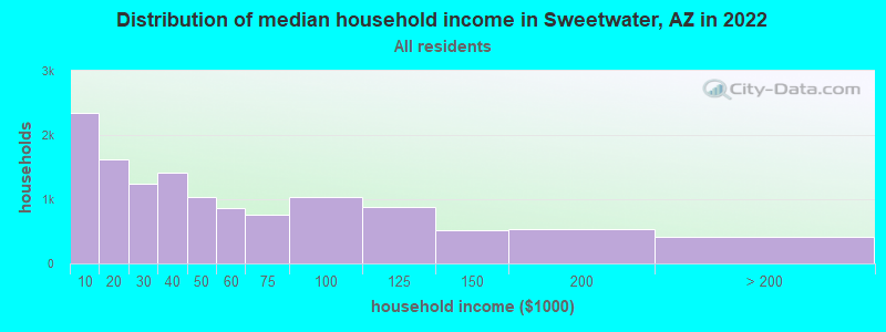
| Sweetwater: | $22,999 |
| AZ: | $74,568 |
Estimated per capita income in 2022: $14,272 (it was $6,188 in 2000)
Sweetwater CCD income, earnings, and wages data
Estimated median house or condo value in 2022: $33,621 (it was $19,700 in 2000)
| Sweetwater: | $33,621 |
| AZ: | $402,800 |
Mean prices in 2022: all housing units: $131,025; detached houses: $148,206; townhouses or other attached units: $108,704; mobile homes: $81,811; occupied boats, rvs, vans, etc.: $11,371
Detailed information about poverty and poor residents in Sweetwater, AZ


- 5,47696.8%American Indian alone
- 961.7%White alone
- 400.7%Two or more races
- 380.7%Hispanic
- 60.1%Native Hawaiian and Other
Pacific Islander alone - 10.02%Other race alone

 Recent articles from our blog. Our writers, many of them Ph.D. graduates or candidates, create easy-to-read articles on a wide variety of topics.
Current Local Time: MST (no DST) time zone
Land area: 1154.6 square miles.
Population density: 4.9 people per square mile (very low).

| Sweetwater CCD: | 1.0% ($199) |
| Arizona: | 0.9% ($962) |
Nearest city with pop. 50,000+: Coconino, AZ (165.3 miles  , pop. 74,488).
Nearest city with pop. 200,000+: Albuquerque, NM (189.5 miles , pop. 448,607).
Nearest city with pop. 1,000,000+: Phoenix, AZ (270.5 miles , pop. 1,321,045).
Nearest cities:
Latitude: 36.73 N, Longitude: 109.34 W
Area code commonly used in this area: 928

| Here: | 7.3% |
| Arizona: | 3.8% |

- Educational services (27.7%)
- Public administration (13.5%)
- Construction (12.2%)
- Accommodation & food services (7.3%)
- Arts, entertainment, recreation (6.3%)
- Health care (5.0%)
- Utilities (4.4%)

- Construction (23.5%)
- Educational services (18.6%)
- Public administration (10.9%)
- Utilities (9.1%)
- Arts, entertainment, recreation (5.1%)
- Health care (4.3%)
- Religious, grantmaking, civic, professional, similar organizations (3.4%)

- Educational services (36.2%)
- Public administration (15.9%)
- Accommodation & food services (11.8%)
- Arts, entertainment, recreation (7.4%)
- Food & beverage stores (5.7%)
- Health care (5.5%)
- Apparel (2.6%)

- Building and grounds cleaning and maintenance occupations (9.4%)
- Preschool, kindergarten, elementary, and middle school teachers (9.2%)
- Other office and administrative support workers, including supervisors (5.5%)
- Information and record clerks, except customer service representatives (5.2%)
- Cooks and food preparation workers (4.0%)
- Construction laborers (3.8%)
- Cashiers (3.7%)

- Building and grounds cleaning and maintenance occupations (11.7%)
- Construction laborers (7.9%)
- Metal workers and plastic workers (6.1%)
- Laborers and material movers, hand (4.9%)
- Electrical equipment mechanics and other installation, maintenance, and repair workers, including supervisors (4.5%)
- Vehicle and mobile equipment mechanics, installers, and repairers (3.8%)
- Electricians (3.4%)

- Preschool, kindergarten, elementary, and middle school teachers (15.1%)
- Other office and administrative support workers, including supervisors (10.7%)
- Information and record clerks, except customer service representatives (7.9%)
- Building and grounds cleaning and maintenance occupations (7.4%)
- Cashiers (7.2%)
- Cooks and food preparation workers (6.6%)
- Other teachers, instructors, education, training, and library occupations (5.4%)
Average climate in Sweetwater, Arizona
Based on data reported by over 4,000 weather stations


Earthquake activity:
Sweetwater-area historical earthquake activity is significantly above Arizona state average. It is 1634% greater than the overall U.S. average.On 6/28/1992 at 11:57:34, a magnitude 7.6 (6.2 MB, 7.6 MS, 7.3 MW, Depth: 0.7 mi, Class: Major, Intensity: VIII - XII) earthquake occurred 442.0 miles away from Sweetwater center, causing 3 deaths (1 shaking deaths, 2 other deaths) and 400 injuries, causing $100,000,000 total damage and $40,000,000 insured losses
On 10/16/1999 at 09:46:44, a magnitude 7.4 (6.3 MB, 7.4 MS, 7.2 MW, 7.3 ML) earthquake occurred 427.5 miles away from the city center
On 5/19/1940 at 04:36:40, a magnitude 7.2 (7.2 UK) earthquake occurred 434.6 miles away from the city center, causing $33,000,000 total damage
On 10/3/1915 at 06:52:48, a magnitude 7.6 (7.6 UK) earthquake occurred 512.0 miles away from the city center
On 8/18/1959 at 06:37:13, a magnitude 7.7 (7.7 UK) earthquake occurred 546.1 miles away from Sweetwater center, causing $26,000,000 total damage
On 9/2/1992 at 10:26:20, a magnitude 5.9 (5.7 MB, 5.6 MS, 5.6 MW, 5.9 ML, Depth: 9.3 mi, Class: Moderate, Intensity: VI - VII) earthquake occurred 229.7 miles away from Sweetwater center
Magnitude types: body-wave magnitude (MB), local magnitude (ML), surface-wave magnitude (MS), moment magnitude (MW)
Natural disasters:
The number of natural disasters in Apache County (12) is smaller than the US average (15).Major Disasters (Presidential) Declared: 6
Emergencies Declared: 3
Causes of natural disasters: Floods: 4, Fires: 3, Storms: 3, Winter Storms: 2, Drought: 1, Flash Flood: 1, Heavy Rain: 1, Hurricane: 1, Tornado: 1, Other: 1 (Note: some incidents may be assigned to more than one category).
Colleges/universities with over 2000 students nearest to Sweetwater:
- San Juan College (about 65 miles; Farmington, NM; Full-time enrollment: 5,112)
- Fort Lewis College (about 90 miles; Durango, CO; FT enrollment: 3,631)
- Colorado Mesa University (about 168 miles; Grand Junction, CO; FT enrollment: 7,671)
- Coconino Community College (about 169 miles; Flagstaff, AZ; FT enrollment: 2,090)
- Northern Arizona University (about 169 miles; Flagstaff, AZ; FT enrollment: 22,494)
- Western State Colorado University (about 183 miles; Gunnison, CO; FT enrollment: 2,023)
- University of Phoenix-Albuquerque Campus (about 188 miles; Albuquerque, NM; FT enrollment: 2,335)
Points of interest:
Notable locations in Sweetwater: Red Rock Trading Post (A), Buffalo Pass Campground (B), Rock Point Trading Post (C), Floating House Ruins (D), Rock Point Community School Fire Department (E), Teec Nos Pos Ambulance Service (F), Teec Nos Pos Chapter House (G). Display/hide their locations on the map
Church in Sweetwater: Navajo Lutheran Missions (A). Display/hide its location on the map
Lakes and reservoirs: Big Lake (A), Walker Creek Reservoir (B). Display/hide their locations on the map
Streams, rivers, and creeks: Blackhorse Creek (A), Dry Farm Wash (B), Cove Wash (C), Lukachukai Creek (D), Sweetwater Wash (E), Standing Redrock Creek (F), Kit Sili Wash (G), Pine Wash (H), Tyende Creek (I). Display/hide their locations on the map
Parks in Sweetwater include: Tohache Recreation Area (1), Mexican Water Recreation Area (2). Display/hide their locations on the map
| This place: | 3.3 people |
| Arizona: | 2.6 people |
| This place: | 73.3% |
| Whole state: | 66.2% |
| This place: | 9.1% |
| Whole state: | 7.8% |
Likely homosexual households (counted as self-reported same-sex unmarried-partner households)
- Lesbian couples: 0.4% of all households
- Gay men: 0.5% of all households
| This place: | 48.3% |
| Whole state: | 13.9% |
| This place: | 30.0% |
| Whole state: | 6.2% |
For population 15 years and over in Sweetwater:

- Never married: 39.6%
- Now married: 49.1%
- Separated: 2.8%
- Widowed: 7.0%
- Divorced: 4.3%
For population 25 years and over in Sweetwater:
- High school or higher: 51.6%
- Bachelor's degree or higher: 8.0%
- Graduate or professional degree: 3.7%
- Unemployed: 23.6%
- Mean travel time to work (commute): 50.9 minutes


| Here: | 32.3 |
| Arizona average: | 13.1 |
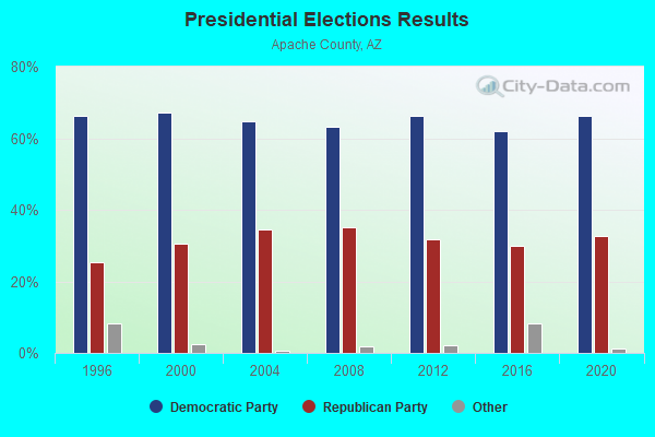
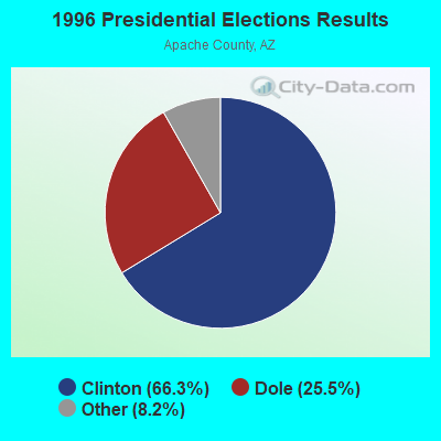
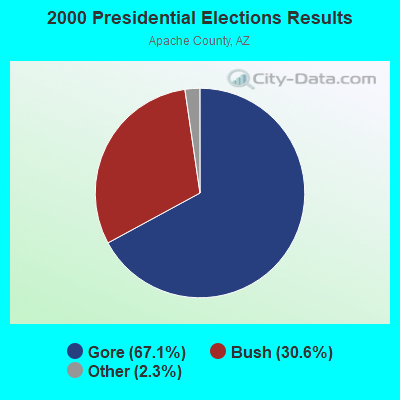
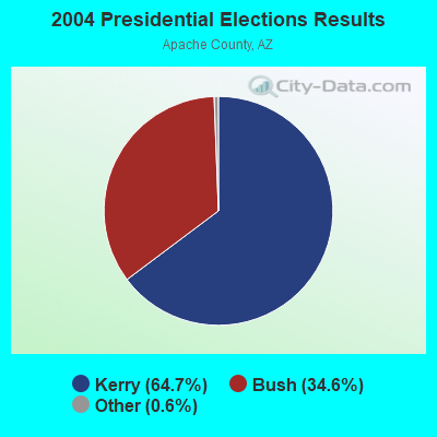
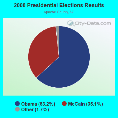
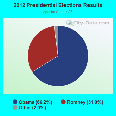
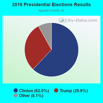
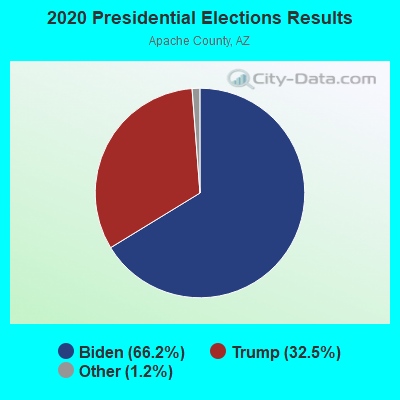
Graphs represent county-level data. Detailed 2008 Election Results
Religion statistics for Sweetwater, AZ (based on Apache County data)
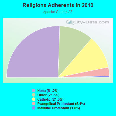
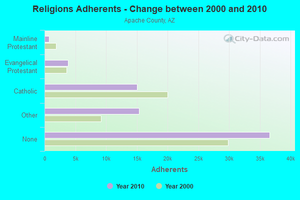
| Religion | Adherents | Congregations |
|---|---|---|
| Other | 15,377 | 35 |
| Catholic | 15,000 | 13 |
| Evangelical Protestant | 3,834 | 73 |
| Mainline Protestant | 715 | 11 |
| None | 36,592 | - |
Food Environment Statistics:
| Apache County: | 1.58 / 10,000 pop. |
| Arizona: | 1.36 / 10,000 pop. |
| This county: | 0.57 / 10,000 pop. |
| Arizona: | 0.55 / 10,000 pop. |
| This county: | 4.74 / 10,000 pop. |
| Arizona: | 2.47 / 10,000 pop. |
| Apache County: | 2.87 / 10,000 pop. |
| State: | 6.21 / 10,000 pop. |
| Here: | 12.8% |
| Arizona: | 8.0% |
| Apache County: | 31.5% |
| Arizona: | 22.8% |
| Apache County: | 10.2% |
| Arizona: | 14.2% |
Strongest AM radio stations in Sweetwater:
- KTNN (660 AM; 50 kW; WINDOW ROCK, AZ; Owner: THE NAVAJO NATION)
- KHAC (880 AM; 43 kW; TSE BONITO, NM; Owner: WESTERN INDIAN MINISTRIES, INC.)
- KNZZ (1100 AM; 50 kW; GRAND JUNCTION, CO; Owner: M B C GRAND BROADCASTING, INC.)
- KENN (1390 AM; 10 kW; FARMINGTON, NM; Owner: WINTON ROAD BROADCASTING CO, LLC)
- KKOB (770 AM; 50 kW; ALBUQUERQUE, NM; Owner: CITADEL BROADCASTING COMPANY)
- KNDN (960 AM; 5 kW; FARMINGTON, NM; Owner: BASIN BROADCASTING CO.)
- KMIA (710 AM; 50 kW; BLACK CANYON CITY, AZ; Owner: ENTRAVISION HOLDINGS, LLC)
- KRZE (1280 AM; 5 kW; FARMINGTON, NM; Owner: J. THOMAS DEVELOPMENT OF NM, INC.)
- KFNX (1100 AM; 50 kW; CAVE CREEK, AZ; Owner: NORTH AMERICAN BROADCASTING CO., INC.)
- KALL (700 AM; 50 kW; NORTH SALT LAKE CITY, UT; Owner: CITICASTERS LICENSES, L.P.)
- KDWN (720 AM; 50 kW; LAS VEGAS, NV; Owner: RADIO NEVADA CORP.)
- KIUP (930 AM; 5 kW; DURANGO, CO; Owner: FOUR CORNERS BROADCASTING, LLC)
- KLTT (670 AM; 50 kW; COMMERCE CITY, CO; Owner: KLZ RADIO, INC.)
Strongest FM radio stations in Sweetwater:
- K289AD (105.7 FM; CHINLE, AZ; Owner: PROCLAIMING CHRIST'S LOVE MINISTRIES)
- KRTZ (98.7 FM; CORTEZ, CO; Owner: WINTON ROAD BROADCASTING CO., LLC)
- KFXR-FM (107.3 FM; CHINLE, AZ; Owner: CLEAR CHANNEL BROADCASTING LICENSES, INC.)
- K248AJ (97.5 FM; MONTICELLO, UT; Owner: PROCLAIMING CHRIST'S LOVE MINISTRIES)
- KRMH (89.7 FM; RED MESA, AZ; Owner: RED MESA UNIFIED SCHOOL DIST NO. 27)
TV broadcast stations around Sweetwater:
- K08HQ (Channel 8; CHINLE, AZ; Owner: KOB-TV, LLC)
FCC Registered Cell Phone Towers:
2 (See the full list of FCC Registered Cell Phone Towers in Sweetwater)FCC Registered Antenna Towers:
6 (See the full list of FCC Registered Antenna Towers)FCC Registered Broadcast Land Mobile Towers:
1- Sweetwater Domestic Water Reservoir (Lat: 36.911111 Lon: -109.368444), Call Sign: KNHM241,
Assigned Frequencies: 173.203 MHz, Grant Date: 06/18/2013, Expiration Date: 09/15/2023, Cancellation Date: 11/18/2023, Registrant: Navajo Tribal Utility Authority, North Hwy Route 12, Fort Defiance, AZ 86504-0170, Phone: (928) 729-4705, Fax: (928) 729-4670, Email:
FCC Registered Microwave Towers:
2- Sweetwater, Near Bia Route 5046 / 0.7 Miles Sw Of Sweetwater Chapter Hous (Lat: 36.848111 Lon: -109.437889), Type: Ltower, Structure height: 60.6 m, Call Sign: WQLK539,
Assigned Frequencies: 6404.79 MHz, 11075.0 MHz, 11155.0 MHz, 11155.0 MHz, 10915.0 MHz, 6404.79 MHz, 11035.0 MHz, 10835.0 MHz, 10755.0 MHz, 10875.0 MHz, 10955.0 MHz, Grant Date: 02/25/2020, Expiration Date: 02/23/2030, Certifier: Justin E Hinkle, Registrant: Americas Communications LLC, 6100 W Gila Springs Place Ste 7, Chandler, AZ 85226, Phone: (602) 304-1760, Fax: (877) 284-0791, Email:
- RFBUTTE, Mp 32 Ir 30 (Lat: 36.460944 Lon: -109.096111), Type: Tower, Structure height: 15.2 m, Call Sign: WQOF807,
Assigned Frequencies: 17815.0 MHz, Grant Date: 11/18/2021, Expiration Date: 09/13/2031, Certifier: Christopher L Harris, Registrant: Conterra Ultra Broadband, LLC, 2101 Rexford Road Suite 200 E, Charlotte, NC 28211, Phone: (704) 936-1801, Fax: (704) 936-1801, Email:

- 56.6%Wood
- 30.0%Bottled, tank, or LP gas
- 6.3%Coal or coke
- 3.7%Electricity
- 2.3%Other fuel
- 0.7%Fuel oil, kerosene, etc.
- 0.5%Utility gas

- 57.6%Bottled, tank, or LP gas
- 26.5%Utility gas
- 5.1%Wood
- 3.5%Other fuel
- 2.7%No fuel used
- 2.3%Electricity
- 2.3%Coal or coke
Sweetwater compared to Arizona state average:
- Median household income significantly below state average.
- Median house value significantly below state average.
- Black race population percentage significantly below state average.
- Hispanic race population percentage significantly below state average.
- Median age below state average.
- Foreign-born population percentage significantly below state average.
- Renting percentage below state average.
- Length of stay since moving in significantly above state average.
- Number of rooms per house significantly below state average.
- House age significantly below state average.
- Number of college students below state average.
- Percentage of population with a bachelor's degree or higher significantly below state average.
Sweetwater on our top lists:
- #1 on the list of "Top 101 cities with largest percentage of males in occupations: special education teachers (population 5,000+)"
- #1 on the list of "Top 101 cities with largest percentage of males in occupations: secondary school teachers (population 5,000+)"
- #2 on the list of "Top 101 cities with the largest house values disparities (population 5,000+)"
- #3 on the list of "Top 101 cities with largest percentage of females in occupations: preschool, kindergarten, elementary and middle school teachers (population 5,000+)"
- #5 on the list of "Top 101 cities with largest percentage of males in occupations: child care workers (population 5,000+)"
- #6 on the list of "Top 101 cities with largest percentage of workers with very long commute times (90 or more minutes) (population 5,000+)"
- #7 on the list of "Top 101 cities with largest percentage of males in occupations: construction laborers (population 5,000+)"
- #7 on the list of "Top 101 cities with largest percentage of females in occupations: religious workers (population 5,000+)"
- #19 on the list of "Top 101 cities with largest percentage of males in industries: rail transportation (population 5,000+)"
- #20 on the list of "Top 101 cities with largest percentage of males in industries: religious, grantmaking, civic, professional, and similar organizations (population 5,000+)"
- #26 on the list of "Top 101 cities with largest percentage of males in industries: utilities (population 5,000+)"
- #35 on the list of "Top 101 cities with largest percentage of females in industries: wood products (population 5,000+)"
- #39 on the list of "Top 100 cities with largest land areas (pop. 5,000+)"
- #55 on the list of "Top 101 cities with largest percentage of females in industries: apparel (population 5,000+)"
- #57 on the list of "Top 101 cities with largest percentage of females in industries: educational services (population 5,000+)"
- #64 on the list of "Top 100 cities with longest commuting times"
- #78 on the list of "Top 101 cities with largest percentage of females in industries: food and beverage stores (population 5,000+)"
- #94 on the list of "Top 100 least-educated cities (pop. 5,000+)"
- #48 (86514) on the list of "Top 101 zip codes with the largest percentage of Welsh first ancestries"
- #56 (86514) on the list of "Top 101 zip codes with the smallest percentage of taxpayers reporting profit/loss from business in 2012 (pop 1,000+)"
- #2 on the list of "Top 101 counties with the lowest Particulate Matter (PM2.5) Annual air pollution readings in 2012 (µg/m3)"
- #29 on the list of "Top 101 counties with the largest increase in the number of deaths per 1000 residents 2000-2006 to 2007-2013 (pop. 50,000+)"
- #75 on the list of "Top 101 counties with the highest percentage of residents relocating from other counties between 2010 and 2011 (pop. 50,000+)"
- #78 on the list of "Top 101 counties with highest percentage of residents voting for Obama (Democrat) in the 2012 Presidential Election (pop. 50,000+)"
- #84 on the list of "Top 101 counties with the highest percentage of residents relocating to other counties in 2011 (pop. 50,000+)"