Sweet, Idaho
Submit your own pictures of this place and show them to the world
- OSM Map
- General Map
- Google Map
- MSN Map

| Males: 602 | |
| Females: 526 |
| Median resident age: | 41.5 years |
| Idaho median age: | 33.2 years |
Zip code: 83657
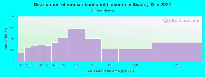
| Sweet: | $62,715 |
| ID: | $72,785 |
Estimated per capita income in 2022: $31,528 (it was $14,210 in 2000)
Sweet CCD income, earnings, and wages data
Estimated median house or condo value in 2022: $618,438 (it was $145,300 in 2000)
| Sweet: | $618,438 |
| ID: | $432,500 |
Mean prices in 2022: all housing units: $320,118; detached houses: $332,233; townhouses or other attached units: $408,451; mobile homes: $167,007
Detailed information about poverty and poor residents in Sweet, ID


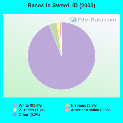
- 97893.9%White alone
- 413.9%Hispanic
- 121.2%Two or more races
- 80.8%American Indian alone
- 20.2%Other race alone
- 10.10%Asian alone
Races in Sweet detailed stats: ancestries, foreign born residents, place of birth
According to our research of Idaho and other state lists, there was 1 registered sex offender living in Sweet, Idaho as of May 23, 2024.
The ratio of all residents to sex offenders in Sweet is 1,128 to 1.
The ratio of registered sex offenders to all residents in this city is much lower than the state average.
 Recent articles from our blog. Our writers, many of them Ph.D. graduates or candidates, create easy-to-read articles on a wide variety of topics.
Current Local Time: MST time zone
Elevation: 2560 feet
Land area: 453.6 square miles.
Population density: 2.5 people per square mile (very low).

| Sweet CCD: | 0.6% ($803) |
| Idaho: | 1.0% ($1,007) |
Nearest city with pop. 50,000+: Boise, ID  (37.2 miles , pop. 185,787).
Nearest city with pop. 200,000+: Northwest Clackamas, OR (321.7 miles , pop. 224,220).
Nearest city with pop. 1,000,000+: Los Angeles, CA (704.7 miles , pop. 3,694,820).
Nearest cities:
), ), Latitude: 44.15 N, Longitude: 116.31 W
Area code: 208

| Here: | 3.8% |
| Idaho: | 3.1% |
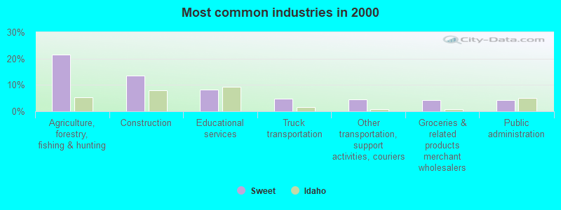
- Agriculture, forestry, fishing & hunting (21.6%)
- Construction (13.6%)
- Educational services (8.3%)
- Truck transportation (4.8%)
- Other transportation, support activities, couriers (4.5%)
- Groceries & related products merchant wholesalers (4.3%)
- Public administration (4.3%)
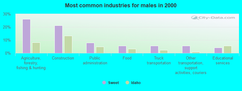
- Agriculture, forestry, fishing & hunting (25.9%)
- Construction (21.2%)
- Public administration (8.0%)
- Food (5.7%)
- Truck transportation (5.7%)
- Other transportation, support activities, couriers (5.7%)
- Educational services (4.2%)

- Agriculture, forestry, fishing & hunting (16.7%)
- Educational services (12.9%)
- Groceries & related products merchant wholesalers (9.1%)
- Accommodation & food services (8.6%)
- Food & beverage stores (8.1%)
- Construction (4.8%)
- Miscellaneous nondurable goods merchant wholesalers (4.8%)
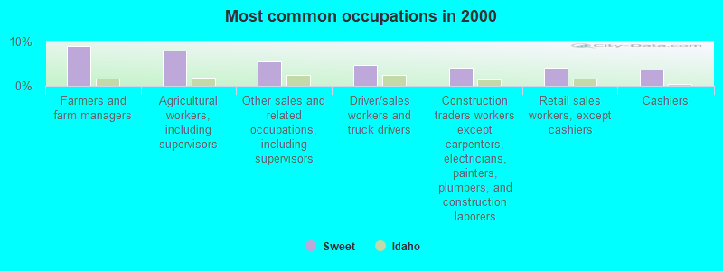
- Farmers and farm managers (9.0%)
- Agricultural workers, including supervisors (8.0%)
- Other sales and related occupations, including supervisors (5.5%)
- Driver/sales workers and truck drivers (4.8%)
- Construction traders workers except carpenters, electricians, painters, plumbers, and construction laborers (4.0%)
- Retail sales workers, except cashiers (4.0%)
- Cashiers (3.8%)
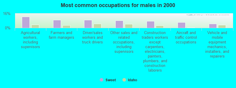
- Agricultural workers, including supervisors (12.3%)
- Farmers and farm managers (9.0%)
- Driver/sales workers and truck drivers (9.0%)
- Other sales and related occupations, including supervisors (8.0%)
- Construction traders workers except carpenters, electricians, painters, plumbers, and construction laborers (7.5%)
- Aircraft and traffic control occupations (6.1%)
- Vehicle and mobile equipment mechanics, installers, and repairers (4.7%)

- Farmers and farm managers (9.1%)
- Retail sales workers, except cashiers (8.6%)
- Cashiers (8.1%)
- Other production occupations, including supervisors (6.5%)
- Preschool, kindergarten, elementary, and middle school teachers (5.9%)
- Cooks and food preparation workers (5.4%)
- Bookkeeping, accounting, and auditing clerks (4.8%)
Average climate in Sweet, Idaho
Based on data reported by over 4,000 weather stations


(lower is better)
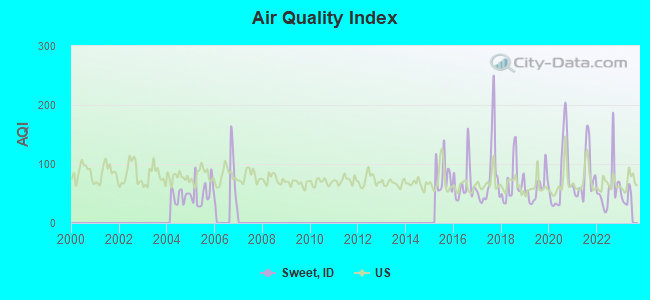
Air Quality Index (AQI) level in 2022 was 58.2. This is better than average.
| City: | 58.2 |
| U.S.: | 72.6 |
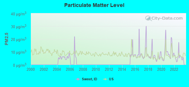
Particulate Matter (PM2.5) [µg/m3] level in 2022 was 6.41. This is better than average. Closest monitor was 16.9 miles away from the city center.
| City: | 6.41 |
| U.S.: | 8.11 |
Earthquake activity:
Sweet-area historical earthquake activity is significantly above Idaho state average. It is 2045% greater than the overall U.S. average.On 10/28/1983 at 14:06:06, a magnitude 7.3 (6.2 MB, 7.3 MS, 7.0 MW, Class: Major, Intensity: VIII - XII) earthquake occurred 124.5 miles away from the city center, causing 2 deaths (2 shaking deaths) and 3 injuries, causing $15,000,000 total damage
On 8/18/1959 at 06:37:13, a magnitude 7.7 (7.7 UK) earthquake occurred 280.9 miles away from Sweet center, causing $26,000,000 total damage
On 10/3/1915 at 06:52:48, a magnitude 7.6 (7.6 UK) earthquake occurred 259.6 miles away from Sweet center
On 3/31/2020 at 23:52:30, a magnitude 6.5 (6.5 MW, Depth: 7.5 mi, Class: Strong, Intensity: VII - IX) earthquake occurred 62.8 miles away from the city center
On 12/16/1954 at 11:07:12, a magnitude 7.0 (7.0 UK) earthquake occurred 353.3 miles away from the city center
On 12/21/1932 at 06:10:09, a magnitude 7.2 (7.2 UK) earthquake occurred 400.8 miles away from the city center
Magnitude types: body-wave magnitude (MB), surface-wave magnitude (MS), moment magnitude (MW)
Natural disasters:
The number of natural disasters in Gem County (5) is a lot smaller than the US average (15).Major Disasters (Presidential) Declared: 3
Emergencies Declared: 1
Causes of natural disasters: Floods: 3, Storms: 2, Heavy Rain: 1, Hurricane: 1, Other: 1 (Note: some incidents may be assigned to more than one category).
Colleges/universities with over 2000 students nearest to Sweet:
- Treasure Valley Community College (about 35 miles; Ontario, OR; Full-time enrollment: 2,055)
- Boise State University (about 38 miles; Boise, ID; FT enrollment: 16,774)
- College of Western Idaho (about 39 miles; Nampa, ID; FT enrollment: 6,300)
- Northwest Nazarene University (about 43 miles; Nampa, ID; FT enrollment: 2,290)
- Eastern Oregon University (about 120 miles; La Grande, OR; FT enrollment: 3,127)
- College of Southern Idaho (about 143 miles; Twin Falls, ID; FT enrollment: 5,051)
- Lewis-Clark State College (about 161 miles; Lewiston, ID; FT enrollment: 3,199)
Public elementary/middle school in Sweet:
- SWEET MONTOUR ELEMENTARY SCHOOL (Students: 68, Location: 6600 SWEET-OLA HIGHWAY, Grades: KG-6)
Points of interest:
Notable locations in Sweet: Indian Jakes (A), Van Duesan Ranch (B), Antelope Campground (C), Sage Hen Dam Recreation Site (D), Third Fork Guard Station (E), Third Fork Project Camp (F), Hollywood Point Campground (G), Eastside Campground (H), Sage Hen Campground (I), Butte Ranch (J), Gem County Fire District 2 Sweet Station (K), Gem County Fire District 2 Ola Station (L). Display/hide their locations on the map
Cemetery: Sweet Cemetery (1). Display/hide its location on the map
Lakes and reservoirs: Beech Lake (A), Gabes Bathtub (B), Sage Hen Reservoir (C). Display/hide their locations on the map
Creeks: Anderson Creek (A), Bristol Creek (B), Brush Creek (C), Church Creek (D), Coon Creek (E), Corral Creek (F), Fourmile Creek (G), Jackson Creek (H), Jakes Creek (I). Display/hide their locations on the map
Drinking water stations with addresses in Sweet and their reported violations in the past:
TRIANGLE RESTAURANT (Population served: 50, Groundwater):Past health violations:Past monitoring violations:
- MCL, Monthly (TCR) - In JAN-2006, Contaminant: Coliform. Follow-up actions: St Public Notif requested (AUG-18-2005), St Public Notif received (NOV-16-2005), St Compliance achieved (AUG-21-2006)
- MCL, Monthly (TCR) - Between JUL-2005 and SEP-2005, Contaminant: Coliform. Follow-up actions: St Public Notif requested (AUG-18-2005), St Public Notif received (NOV-16-2005), St Compliance achieved (AUG-21-2006)
- 3 routine major monitoring violations
- One regular monitoring violation
| This place: | 2.5 people |
| Idaho: | 2.7 people |
| This place: | 74.7% |
| Whole state: | 69.6% |
| This place: | 5.1% |
| Whole state: | 6.3% |
Likely homosexual households (counted as self-reported same-sex unmarried-partner households)
- Lesbian couples: 0.8% of all households
- Gay men: 0.2% of all households
| This place: | 6.0% |
| Whole state: | 11.8% |
| This place: | 3.4% |
| Whole state: | 4.6% |
For population 15 years and over in Sweet:
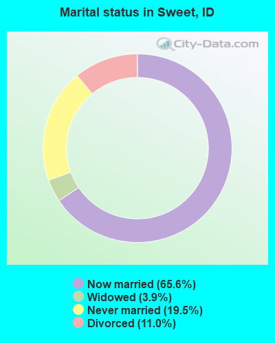
- Never married: 19.5%
- Now married: 65.6%
- Separated: 0.0%
- Widowed: 3.9%
- Divorced: 11.0%
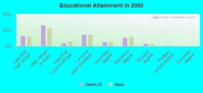
For population 25 years and over in Sweet:
- High school or higher: 83.3%
- Bachelor's degree or higher: 18.8%
- Graduate or professional degree: 5.1%
- Unemployed: 8.3%
- Mean travel time to work (commute): 21.2 minutes
| Here: | 10.0 |
| Idaho average: | 11.1 |
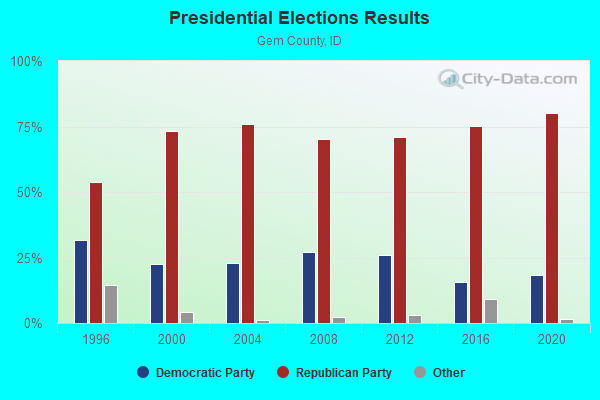
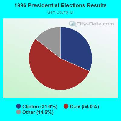
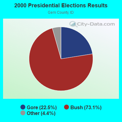
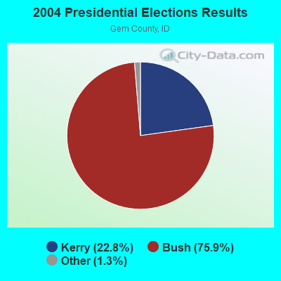
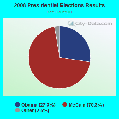
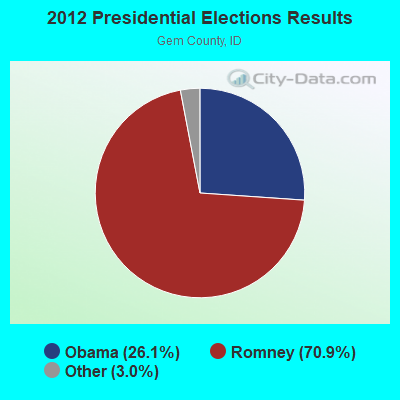
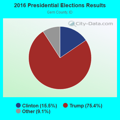
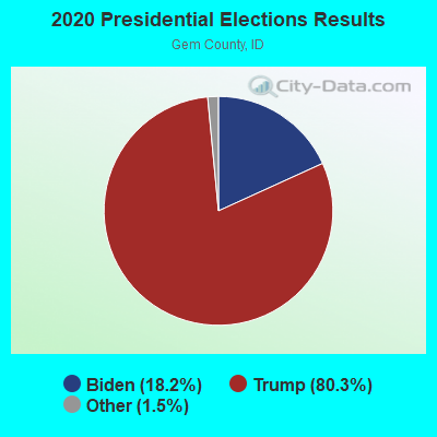
Graphs represent county-level data. Detailed 2008 Election Results
Religion statistics for Sweet, ID (based on Gem County data)
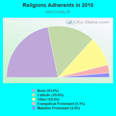
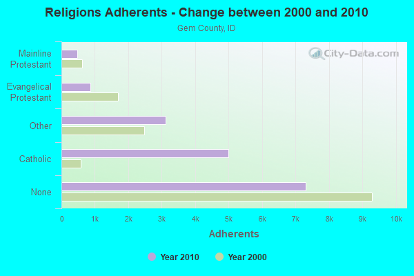
| Religion | Adherents | Congregations |
|---|---|---|
| Catholic | 4,989 | 1 |
| Other | 3,108 | 9 |
| Evangelical Protestant | 858 | 10 |
| Mainline Protestant | 468 | 5 |
| None | 7,296 | - |
Food Environment Statistics:
| Gem County: | 1.22 / 10,000 pop. |
| Idaho: | 1.88 / 10,000 pop. |
| This county: | 0.61 / 10,000 pop. |
| Idaho: | 0.53 / 10,000 pop. |
| Gem County: | 2.43 / 10,000 pop. |
| State: | 3.87 / 10,000 pop. |
| Gem County: | 6.08 / 10,000 pop. |
| Idaho: | 7.75 / 10,000 pop. |
| Gem County: | 8.7% |
| Idaho: | 7.7% |
| Gem County: | 30.4% |
| Idaho: | 25.7% |
| Gem County: | 12.3% |
| State: | 11.7% |
Strongest AM radio stations in Sweet:
- KWEI (1260 AM; 50 kW; WEISER, ID; Owner: TREASURE VALLEY BROADCASTING CO.)
- KBOI (670 AM; 50 kW; BOISE, ID; Owner: CITADEL BROADCASTING COMPANY)
- KBSU (730 AM; 15 kW; BOISE, ID; Owner: IDAHO STATE BOARD OF EDUCATION)
- KBGN (1060 AM; daytime; 10 kW; CALDWELL, ID; Owner: NELSON M. AND KAREN E. WILSON)
- KGEM (1140 AM; 10 kW; BOISE, ID; Owner: JOURNAL BROADCAST CORPORATION)
- KIDO (580 AM; 5 kW; NAMPA, ID; Owner: CITICASTERS LICENSES, L.P.)
- KFXD (630 AM; 5 kW; BOISE, ID; Owner: CITICASTERS LICENSES, L.P.)
- KSRV (1380 AM; 5 kW; ONTARIO, OR; Owner: HBG-RADIO ONTARIO LLC)
- KKIC (950 AM; 4 kW; BOISE, ID; Owner: WESTERN PACIFIC, INC)
- KTIK (1350 AM; 5 kW; NAMPA, ID; Owner: CITADEL BROADCASTING COMPANY)
- KERR (750 AM; 50 kW; POLSON, MT; Owner: ANDERSON RADIO BROADCASTING, INC.)
- KTBI (810 AM; daytime; 50 kW; EPHRATA, WA; Owner: TACOMA BROADCASTERS, INCORPORATED)
- KIOV (1450 AM; 1 kW; PAYETTE, ID; Owner: ASSOCIATES COMMUNICATIONS OF IDAHO,)
Strongest FM radio stations in Sweet:
- KWEI-FM (99.5 FM; FRUITLAND, ID; Owner: TREASURE VALLEY BROADCASTING CO.)
- KJHY (101.9 FM; EMMETT, ID; Owner: CAPITAL WEST INC)
- KIZN (92.3 FM; BOISE, ID; Owner: CITADEL BROADCASTING COMPANY)
- KKGL (96.9 FM; NAMPA, ID; Owner: CITADEL BROADCASTING COMPANY)
- KQFC (97.9 FM; BOISE, ID; Owner: CITADEL BROADCASTING COMPANY)
- KZMG (93.1 FM; NEW PLYMOUTH, ID; Owner: CITADEL BROADCASTING COMPANY)
- KBSU-FM (90.3 FM; BOISE, ID; Owner: IDAHO STATE BOARD OF EDUCATION)
- KBSX (91.5 FM; BOISE, ID; Owner: IDAHO STATE BOARD OF EDUCATION)
- KCIX (105.9 FM; GARDEN CITY, ID; Owner: CITICASTERS LICENSES, L.P.)
- KRVB (94.9 FM; NAMPA, ID; Owner: JOURNAL BROADCAST CORPORATION)
- KXLT-FM (107.9 FM; EAGLE, ID; Owner: CITICASTERS LICENSES, L.P.)
- KJOT (105.1 FM; BOISE, ID; Owner: JOURNAL BROADCAST CORPORATION)
- KTHI (107.1 FM; CALDWELL, ID; Owner: JOURNAL BROADCAST CORPORATION)
- KBXL (94.1 FM; CALDWELL, ID; Owner: KSPD, INC.)
- KTSY (89.5 FM; CALDWELL, ID; Owner: GEM STATE ADVENTIST ACADEMY)
- KSAS-FM (103.3 FM; CALDWELL, ID; Owner: CITICASTERS LICENSES, L.P.)
- KLTB (104.3 FM; BOISE, ID; Owner: CITICASTERS LICENSES, L.P.)
- KDZY (98.3 FM; MCCALL, ID; Owner: KSPD, INC.)
- KQXR (100.3 FM; PAYETTE, ID; Owner: JOURNAL BROADCAST CORPORATION)
- KSRV-FM (96.1 FM; ONTARIO, OR; Owner: HBG-RADIO ONTARIO LLC)
TV broadcast stations around Sweet:
- KTRV (Channel 12; NAMPA, ID; Owner: IDAHO INDEPENDENT TELEVISION, INC.)
- K30GS (Channel 30; BOISE, ID; Owner: MS COMMUNICATIONS, LLC)
FCC Registered Antenna Towers:
2- Gordon Day, Squaw Butte (Lat: 44.001250 Lon: -116.411389), Type: 24.4, Structure height: 16045 m, Overall height: 24.4 m, Registrant: Day Management Corp. Dba Day Wireless Systems, Dwssites@daywireless.Com, , 22169 Milwa-ukie, Phone: (503) 659-1240
- Dean Ballew, Squaw Butte (Lat: 44.001250 Lon: -116.411389), Type: 24.4, Structure height: 16045 m, Overall height: 24.4 m, Registrant: Day Management Corp. Dba Day Wireless Systems, Dwssites@daywireless.Com, , 22169 Milwa-ukie, Phone: (503) 659-1240
FCC Registered Microwave Towers:
4- New Squaw Butte, Butte Road (Lat: 44.002861 Lon: -116.411417), Type: Gtower, Structure height: 30.5 m, Call Sign: WRJC799,
Assigned Frequencies: 10855.0 MHz, 11545.0 MHz, 11245.0 MHz, 10755.0 MHz, 17820.0 MHz, 17900.0 MHz, 11305.0 MHz, 11425.0 MHz, 11425.0 MHz, 11425.0 MHz... (+44 more), Grant Date: 08/07/2020, Expiration Date: 08/07/2030, Certifier: David Blood, Registrant: Micronet Communications, Inc., 812 Lexington Dr, Plano, TX 75075, Phone: (972) 422-7200, Email:
- SQB Site, Unnamed Rd (Lat: 44.016028 Lon: -116.405278), Type: Ltower, Structure height: 23 m, Overall height: 24 m, Call Sign: WRQB986,
Assigned Frequencies: 6137.92 MHz, 6137.92 MHz, 6137.92 MHz, 6137.92 MHz, 6137.92 MHz, 6137.92 MHz, 6137.92 MHz, 6137.92 MHz, 6137.92 MHz, Grant Date: 04/19/2022, Expiration Date: 04/19/2032, Certifier: Frank Gartin, Registrant: Intelpath, Hinsdale, IL 60522, Phone: (312) 841-9188, Email:
- Squaw, Butte Road (Lat: 44.000833 Lon: -116.411361), Type: Building, Structure height: 3.7 m, Call Sign: WRUX766,
Assigned Frequencies: 10935.0 MHz, 10935.0 MHz, Grant Date: 10/17/2022, Expiration Date: 10/17/2032, Certifier: Joseph W Shelton, Registrant: Micronet Communications, Inc., 812 Lexington Dr, Plano, TX 75075, Phone: (972) 422-7200, Email:
- SQUAW BUTTE, 5.2 Mi W Of (Lat: 44.018778 Lon: -116.405139), Type: Tower, Structure height: 17.7 m, Call Sign: KGG29,
Assigned Frequencies: 5974.90 MHz, 6034.15 MHz, 6093.50 MHz, 11565.0 MHz, 11565.0 MHz, 11645.0 MHz, 11645.0 MHz, 11565.0 MHz, 11565.0 MHz, 11645.0 MHz... (+34 more), Grant Date: 08/11/2020, Expiration Date: 08/01/2030, Certifier: Jerry Piper, Registrant: Intelpath, Hinsdale, IL 60522, Phone: (312) 841-9188, Email:
FCC Registered Amateur Radio Licenses:
7- Call Sign: KD5ECV, Licensee ID: L00266549, Grant Date: 02/04/1999, Expiration Date: 05/04/2008, Cancellation Date: 07/06/2000, Registrant: Lee M Campbell, Sweet, ID 83670
- Call Sign: KE7CJE, Licensee ID: L00947499, Grant Date: 09/22/2014, Expiration Date: 12/02/2024, Certifier: Blake F Probst, Registrant: Blake F Probst, 11500 Sweet Ola Rd, Sweet, ID 83670
- Call Sign: KJ4DAX, Licensee ID: L01385861, Grant Date: 02/02/2018, Expiration Date: 04/01/2028, Certifier: Brian M Spears, Registrant: Brian M Spears, 10485 Panther Gulch Ln, Sweet, ID 83670
- Call Sign: KG7ALT, Licensee ID: L01755909, Grant Date: 12/28/2012, Expiration Date: 12/28/2022, Certifier: Melvin J Bromgard, Registrant: Melvin J Bromgard, 8150 Sweet Ola Hwy, Sweet, ID 83670
- Call Sign: AG6WE, Previous Call Sign: KJ6QZV, Licensee ID: L01659170, Grant Date: 08/13/2021, Expiration Date: 09/01/2031, Certifier: Jonathan J Rice, Registrant: Jonathan J Rice, 9709 Brownlee Liberty Rd, Sweet, ID 83670
- Call Sign: KK6GYY, Licensee ID: L01817960, Grant Date: 10/18/2013, Expiration Date: 10/18/2023, Certifier: Genie Rice, Registrant: Genie J Rice, 9709 Brownlee Liberty Rd, Sweet, ID 83670
- Call Sign: KI7LWD, Licensee ID: L02091827, Grant Date: 03/23/2017, Expiration Date: 03/23/2027, Certifier: Merrell B Dahlstrom Jr, Registrant: Merrell B Dahlstrom Jr, 11300 Sweet Ola Hwy, Sweet, ID 83670
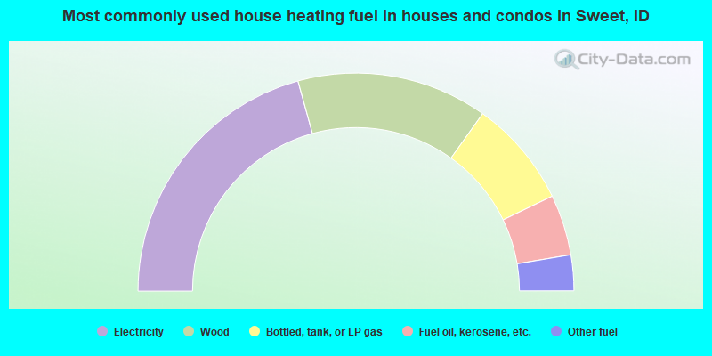
- 41.4%Electricity
- 28.3%Wood
- 15.9%Bottled, tank, or LP gas
- 9.0%Fuel oil, kerosene, etc.
- 5.3%Other fuel
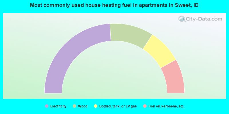
- 47.8%Electricity
- 20.3%Wood
- 15.9%Bottled, tank, or LP gas
- 15.9%Fuel oil, kerosene, etc.
Sweet compared to Idaho state average:
- Black race population percentage significantly below state average.
- Hispanic race population percentage significantly below state average.
- Foreign-born population percentage significantly below state average.
- Renting percentage below state average.
- Length of stay since moving in significantly above state average.
- Number of rooms per house significantly below state average.
- House age significantly below state average.
- Number of college students below state average.
Sweet on our top lists:
- #25 on the list of "Top 101 cities with the largest percentage of people in residential treatment centers for emotionally disturbed children (population 1,000+)"

|
Total of 1 patent application in 2008-2024.