Summit, Kentucky
Submit your own pictures of this place and show them to the world
- OSM Map
- General Map
- Google Map
- MSN Map

| Males: 1,508 | |
| Females: 1,516 |
| Median resident age: | 38.3 years |
| Kentucky median age: | 35.9 years |
Zip code: 42732
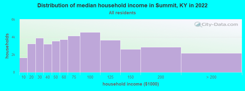
| Summit: | $53,828 |
| KY: | $59,341 |
Estimated per capita income in 2022: $30,786 (it was $15,261 in 2000)
Summit CCD income, earnings, and wages data
Estimated median house or condo value in 2022: $162,957 (it was $67,100 in 2000)
| Summit: | $162,957 |
| KY: | $196,300 |
Mean prices in 2022: all housing units: $253,302; detached houses: $268,311; townhouses or other attached units: $178,850; in 2-unit structures: $141,144; in 3-to-4-unit structures: $176,355; in 5-or-more-unit structures: $316,480; mobile homes: $112,506
Detailed information about poverty and poor residents in Summit, KY


- 2,86398.5%White alone
- 140.5%Asian alone
- 130.4%Hispanic
- 70.2%Black alone
- 70.2%Two or more races
- 30.1%American Indian alone
- 10.03%Other race alone

Races in Summit detailed stats: ancestries, foreign born residents, place of birth
 Recent articles from our blog. Our writers, many of them Ph.D. graduates or candidates, create easy-to-read articles on a wide variety of topics.
Current Local Time: EST time zone
Land area: 103.6 square miles.
Population density: 29 people per square mile (very low).

| Summit CCD: | 0.7% ($441) |
| Kentucky: | 0.8% ($610) |
Nearest city with pop. 50,000+: Louisville, KY  (46.4 miles , pop. 256,231).
Nearest city with pop. 1,000,000+: Chicago, IL (302.0 miles , pop. 2,896,016).
Nearest cities:
), ), ), ), Latitude: 37.64 N, Longitude: 86.15 W
Area code commonly used in this area: 270

| Here: | 3.9% |
| Kentucky: | 3.8% |

- Construction (15.9%)
- Agriculture, forestry, fishing & hunting (12.0%)
- Health care (9.1%)
- Educational services (5.5%)
- Transportation equipment (5.3%)
- Accommodation & food services (3.7%)
- Electrical equipment, appliances, components (3.6%)

- Construction (24.9%)
- Agriculture, forestry, fishing & hunting (17.2%)
- Transportation equipment (5.4%)
- Electrical equipment, appliances, components (4.5%)
- Repair & maintenance (4.4%)
- Public administration (3.4%)
- Motor vehicle & parts dealers (3.0%)

- Health care (20.4%)
- Educational services (11.3%)
- Accommodation & food services (6.9%)
- Professional, scientific, technical services (5.2%)
- Transportation equipment (5.2%)
- Agriculture, forestry, fishing & hunting (4.2%)
- Truck transportation (3.1%)

- Farmers and farm managers (9.1%)
- Other production occupations, including supervisors (7.1%)
- Construction traders workers except carpenters, electricians, painters, plumbers, and construction laborers (4.8%)
- Building and grounds cleaning and maintenance occupations (4.7%)
- Metal workers and plastic workers (4.2%)
- Other sales and related occupations, including supervisors (3.9%)
- Secretaries and administrative assistants (3.7%)

- Farmers and farm managers (13.2%)
- Other sales and related occupations, including supervisors (6.6%)
- Construction traders workers except carpenters, electricians, painters, plumbers, and construction laborers (6.3%)
- Metal workers and plastic workers (6.3%)
- Other production occupations, including supervisors (5.7%)
- Electrical equipment mechanics and other installation, maintenance, and repair workers, including supervisors (5.2%)
- Construction laborers (4.7%)

- Other production occupations, including supervisors (9.2%)
- Secretaries and administrative assistants (9.2%)
- Other office and administrative support workers, including supervisors (7.0%)
- Building and grounds cleaning and maintenance occupations (6.5%)
- Accountants and auditors (6.0%)
- Registered nurses (5.6%)
- Cashiers (4.7%)
Average climate in Summit, Kentucky
Based on data reported by over 4,000 weather stations


(lower is better)

Air Quality Index (AQI) level in 2022 was 63.2. This is about average.
| City: | 63.2 |
| U.S.: | 72.6 |


Particulate Matter (PM2.5) [µg/m3] level in 2022 was 8.02. This is about average. Closest monitor was 16.0 miles away from the city center.
| City: | 8.02 |
| U.S.: | 8.11 |
Tornado activity:
Summit-area historical tornado activity is slightly above Kentucky state average. It is 53% greater than the overall U.S. average.
On 4/3/1974, a category F5 (max. wind speeds 261-318 mph) tornado 21.9 miles away from the Summit place center killed 31 people and injured 270 people and caused between $500,000 and $5,000,000 in damages.
On 4/3/1974, a category F4 (max. wind speeds 207-260 mph) tornado 13.7 miles away from the place center injured 2 people.
Earthquake activity:
Summit-area historical earthquake activity is significantly above Kentucky state average. It is 145% greater than the overall U.S. average.On 4/18/2008 at 09:36:59, a magnitude 5.4 (5.1 MB, 4.8 MS, 5.4 MW, 5.2 MW, Class: Moderate, Intensity: VI - VII) earthquake occurred 110.3 miles away from the city center
On 4/18/2008 at 09:36:59, a magnitude 5.2 (5.2 MW, Depth: 8.9 mi) earthquake occurred 110.2 miles away from Summit center
On 7/27/1980 at 18:52:21, a magnitude 5.2 (5.1 MB, 4.7 MS, 5.0 UK, 5.2 UK) earthquake occurred 126.5 miles away from the city center
On 6/18/2002 at 17:37:15, a magnitude 5.0 (4.3 MB, 4.6 MW, 5.0 LG) earthquake occurred 92.5 miles away from Summit center
On 6/10/1987 at 23:48:54, a magnitude 5.1 (4.9 MB, 4.4 MS, 4.6 MS, 5.1 LG) earthquake occurred 125.0 miles away from the city center
On 4/18/2008 at 15:14:16, a magnitude 4.8 (4.5 MB, 4.8 MW, 4.6 MW, Class: Light, Intensity: IV - V) earthquake occurred 109.3 miles away from the city center
Magnitude types: regional Lg-wave magnitude (LG), body-wave magnitude (MB), surface-wave magnitude (MS), moment magnitude (MW)
Natural disasters:
The number of natural disasters in Hardin County (20) is greater than the US average (15).Major Disasters (Presidential) Declared: 16
Emergencies Declared: 2
Causes of natural disasters: Storms: 14, Floods: 13, Tornadoes: 9, Mudslides: 3, Winter Storms: 2, Blizzard: 1, Freeze: 1, Hurricane: 1, Landslide: 1, Snow: 1, Wind: 1, Other: 1 (Note: some incidents may be assigned to more than one category).
Hospitals and medical centers near Summit:
- TWIN LAKES HOME HEALTH (Home Health Center, about 14 miles away; LEITCHFIELD, KY)
- TWIN LAKES REGIONAL MEDICAL CENTER Acute Care Hospitals (about 14 miles away; LEITCHFIELD, KY)
- LEITCHFIELD DIALYSIS (Dialysis Facility, about 14 miles away; LEITCHFIELD, KY)
- KINDRED NURSING AND REHABILITATION-WOODLAND (Nursing Home, about 16 miles away; ELIZABETHTOWN, KY)
- ELIZABETHTOWN NURSING AND REHABILITATION CENTER (Nursing Home, about 16 miles away; ELIZABETHTOWN, KY)
- MEDCO CENTER OF ELIZABETHTOWN (Nursing Home, about 16 miles away; ELIZABETHTOWN, KY)
- WOODLAND DIALYSIS CENTER (Dialysis Facility, about 16 miles away; ELIZABETHTOWN, KY)
Colleges/universities with over 2000 students nearest to Summit:
- Elizabethtown Community and Technical College (about 17 miles; Elizabethtown, KY; Full-time enrollment: 3,762)
- University of Louisville (about 46 miles; Louisville, KY; FT enrollment: 16,640)
- Bellarmine University (about 48 miles; Louisville, KY; FT enrollment: 3,180)
- Jefferson Community and Technical College (about 48 miles; Louisville, KY; FT enrollment: 7,950)
- Sullivan University (about 48 miles; Louisville, KY; FT enrollment: 5,129)
- Western Kentucky University (about 49 miles; Bowling Green, KY; FT enrollment: 16,942)
- Campbellsville University (about 49 miles; Campbellsville, KY; FT enrollment: 2,948)
Points of interest:
Notable locations in Summit: Arch (A), West 84 Volunteer Fire Department Station 2 (B), West 84 Volunteer Fire Department Station 1 (C). Display/hide their locations on the map
Churches in Summit include: Liberty Chapel (A), Fair Farm Church (B), Meeting Creek Baptist Church (C), Mount Olive Cumberland Church (D), Needham Cumberland Presbyterian Church (E), Pleasant Grove Church (F), Pole Bridge Church (G), Sutzer Creek Church (H), Vertrees Church (I). Display/hide their locations on the map
Cemeteries: Sutzer Creek Cemetery (1), Pleasant Grove Cemetery (2), Dellview Cemetery (3), Old Union Cemetery (4), Horn Cemetery (5), Holbert Cemetery (6), Moore Cemetery (7). Display/hide their locations on the map
Streams, rivers, and creeks: Dry Bed Branch (A), Drakes Creek (B), Beecher Branch (C), Culbertson Branch (D), Vertrees Creek (E), Tinker Run (F), Sutzer Creek (G), Meeting Creek (H), McGuffin Branch (I). Display/hide their locations on the map
| This place: | 2.6 people |
| Kentucky: | 2.5 people |
| This place: | 75.3% |
| Whole state: | 66.9% |
| This place: | 5.1% |
| Whole state: | 6.4% |
Likely homosexual households (counted as self-reported same-sex unmarried-partner households)
- Lesbian couples: 0.1% of all households
- Gay men: 0.2% of all households
| This place: | 9.7% |
| Whole state: | 15.8% |
| This place: | 2.3% |
| Whole state: | 6.6% |
For population 15 years and over in Summit:

- Never married: 22.2%
- Now married: 62.2%
- Separated: 0.2%
- Widowed: 6.0%
- Divorced: 9.6%
For population 25 years and over in Summit:
- High school or higher: 67.3%
- Bachelor's degree or higher: 8.7%
- Graduate or professional degree: 2.7%
- Unemployed: 6.7%
- Mean travel time to work (commute): 34.4 minutes


| Here: | 13.7 |
| Kentucky average: | 13.8 |
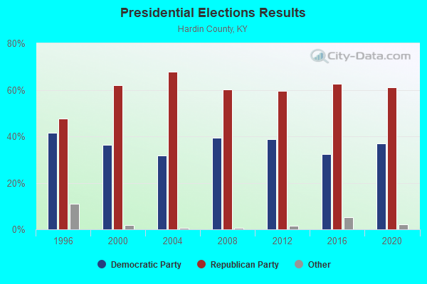
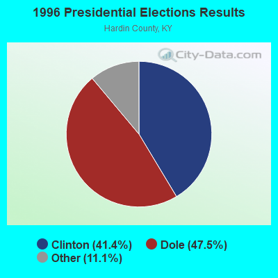
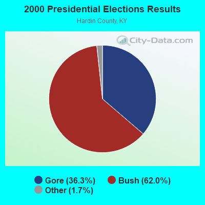

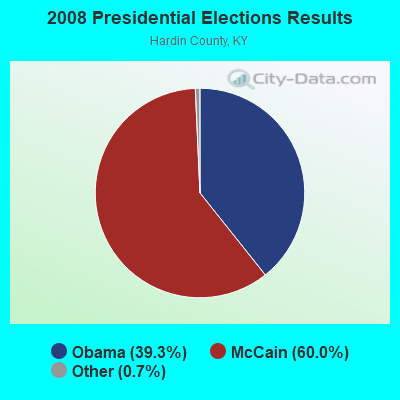
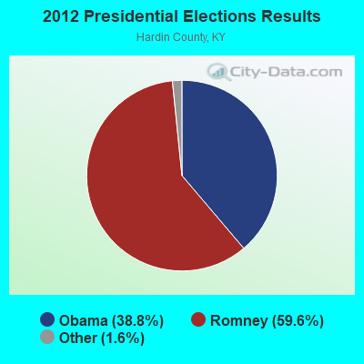
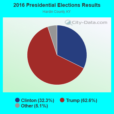

Graphs represent county-level data. Detailed 2008 Election Results
Religion statistics for Summit, KY (based on Hardin County data)
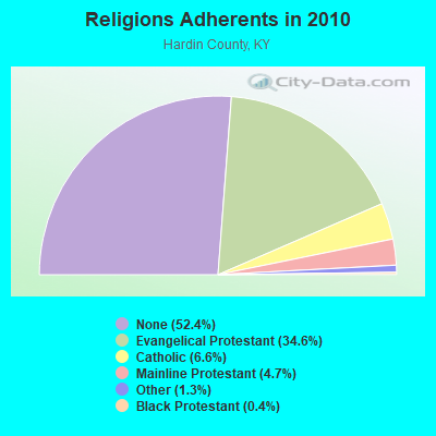

| Religion | Adherents | Congregations |
|---|---|---|
| Evangelical Protestant | 36,503 | 114 |
| Catholic | 6,986 | 6 |
| Mainline Protestant | 4,993 | 26 |
| Other | 1,363 | 4 |
| Black Protestant | 439 | 3 |
| None | 55,259 | - |
Food Environment Statistics:
| This county: | 1.43 / 10,000 pop. |
| State: | 2.19 / 10,000 pop. |
| Hardin County: | 0.20 / 10,000 pop. |
| Kentucky: | 0.25 / 10,000 pop. |
| This county: | 0.51 / 10,000 pop. |
| Kentucky: | 0.74 / 10,000 pop. |
| Hardin County: | 4.60 / 10,000 pop. |
| State: | 4.36 / 10,000 pop. |
| Hardin County: | 5.82 / 10,000 pop. |
| Kentucky: | 5.74 / 10,000 pop. |
| Hardin County: | 12.3% |
| Kentucky: | 11.0% |
| Here: | 30.3% |
| Kentucky: | 30.0% |
| Hardin County: | 13.6% |
| Kentucky: | 15.9% |
8.88% of this county's 2021 resident taxpayers lived in other counties in 2020 ($51,737 average adjusted gross income)
| Here: | 8.88% |
| Kentucky average: | 7.04% |
0.25% of residents moved from foreign countries ($2,224 average AGI)
Hardin County: 0.25% Kentucky average: 0.02%
Top counties from which taxpayers relocated into this county between 2020 and 2021:
| from Jefferson County, KY | |
| from Meade County, KY | |
| from Larue County, KY |
8.87% of this county's 2020 resident taxpayers moved to other counties in 2021 ($50,666 average adjusted gross income)
| Here: | 8.87% |
| Kentucky average: | 6.89% |
0.15% of residents moved to foreign countries ($1,325 average AGI)
Hardin County: 0.15% Kentucky average: 0.01%
Top counties to which taxpayers relocated from this county between 2020 and 2021:
| to Jefferson County, KY | |
| to Meade County, KY | |
| to Larue County, KY |
Strongest AM radio stations in Summit:
- WHAS (840 AM; 50 kW; LOUISVILLE, KY; Owner: CLEAR CHANNEL BROADCASTING LICENSES, INC.)
- WSM (650 AM; 50 kW; NASHVILLE, TN; Owner: GAYLORD ENTERTAINMENT COMPANY)
- WMTL (870 AM; daytime; 0 kW; LEITCHFIELD, KY; Owner: HERITAGE MEDIA OF KENTUCKY INC)
- WAMB (1160 AM; 50 kW; DONELSON, TN; Owner: GREAT SOUTHERN BROADCASTING COMPANY, INC.)
- WKJK (1080 AM; 10 kW; LOUISVILLE, KY; Owner: CLEAR CHANNEL BROADCASTING LICENSES, INC.)
- WKDA (1200 AM; 50 kW; NASHVILLE, TN; Owner: RADIO NASHVILLE, INC.)
- WNQM (1300 AM; 50 kW; NASHVILLE, TN; Owner: WNQM. INC.)
- WLAC (1510 AM; 50 kW; NASHVILLE, TN; Owner: CAPSTAR TX LIMITED PARTNERSHIP)
- WIEL (1400 AM; 1 kW; ELIZABETHTOWN, KY; Owner: ELIZABETHTOWN CBC, INC.)
- WLW (700 AM; 50 kW; CINCINNATI, OH; Owner: JACOR BROADCASTING CORPORATION)
- WKCT (930 AM; 5 kW; BOWLING GREEN, KY; Owner: DAILY NEWS BROADCASTING CO.)
- WXXA (790 AM; 5 kW; LOUISVILLE, KY)
- WKVL (850 AM; daytime; 50 kW; KNOXVILLE, TN; Owner: HORNE RADIO, LLC)
Strongest FM radio stations in Summit:
- WASE (103.5 FM; RADCLIFF, KY; Owner: W & B BROADCASTING, INC.)
- WRZI (101.5 FM; VINE GROVE, KY; Owner: ELIZABETHTOWN CBC, INC.)
- WKUE (90.9 FM; ELIZABETHTOWN, KY; Owner: WESTERN KENTUCKY UNIVERSITY)
- WQXE (98.3 FM; ELIZABETHTOWN, KY; Owner: SKYTOWER COMMUNICATIONS-E'TOWN, INC.)
- WULF (94.3 FM; HARDINSBURG, KY; Owner: SKYTOWER COMMUNICATIONS - 94.3, LLC)
- WBFI (91.5 FM; MCDANIELS, KY; Owner: BETHEL FELLOWSHIP, INC.)
- WLVK (105.5 FM; FORT KNOX, KY; Owner: BIG CAT BROADCASTING, INC.)
- WKHG (104.9 FM; LEITCHFIELD, KY; Owner: HERITAGE MEDIA OF KENTUCKY INC)
- WJCR-FM (90.1 FM; UPTON, KY; Owner: FM 90.1, INC.)
- WXBC (104.3 FM; HARDINSBURG, KY; Owner: BRECKINRIDGE BROADCASTING CO., INC.)
- WRVI (105.9 FM; VALLEY STATION, KY; Owner: SALEM MEDIA OF KENTUCKY, INC.)
- WTHX (107.3 FM; LEBANON JUNCTION, KY; Owner: ELIZABETHTOWN CBC, INC.)
- WKMO (106.3 FM; HODGENVILLE, KY; Owner: ELIZABETHTOWN CBC, INC.)
- WJIE-FM (88.5 FM; OKOLONA, KY; Owner: EVANGEL SCHOOLS, INC.)
- WKLX (100.7 FM; BROWNSVILLE, KY; Owner: CHARLES M. ANDERSON)
- WLME (102.9 FM; CANNELTON, IN; Owner: HANCOCK COMMUNICATIONS, INC)
- WMMG-FM (93.5 FM; BRANDENBURG, KY; Owner: MEADE COUNTY COMMUNICATIONS, INC.)
TV broadcast stations around Summit:
- WKZT-TV (Channel 23; ELIZABETHTOWN, KY; Owner: KENTUCKY AUTHORITY FOR EDUCATIONAL TV)
- W39CJ (Channel 39; ELIZABETHTOWN, KY; Owner: TRINITY BROADCASTING NETWORK)
- WBKI-TV (Channel 34; CAMPBELLSVILLE, KY; Owner: LOUISVILLE COMMUNICATIONS, LLC)
- W24BW (Channel 24; LOUISVILLE, KY; Owner: GREATER LOUISVILLE COMMUNICATIONS)
- WBKI-CA (Channel 28; LOUISVILLE, KY; Owner: LOUISVILLE COMMUNICATIONS, LLC)

Summit fatal accident list:
Jun 6, 2003 08:13 PM, Us-62, Vehicles: 1, Persons: 1, Fatalities: 1
FCC Registered Cell Phone Towers:
1 (See the full list of FCC Registered Cell Phone Towers in Summit)FCC Registered Antenna Towers:
28 (See the full list of FCC Registered Antenna Towers)FCC Registered Microwave Towers:
2- Eastview KY, 1051 Rock Creek Rd (Lat: 37.554889 Lon: -86.079722), Type: Ltower, Structure height: 76.2 m, Overall height: 78.6 m, Call Sign: WQQY360,
Assigned Frequencies: 10855.0 MHz, Grant Date: 03/25/2013, Expiration Date: 03/25/2023, Cancellation Date: 09/23/2013, Certifier: Ronald R Smith, Registrant: Lukas, Nace, Gutierrez & Sachs, LLP, 8300 Greensboro Drive, Suite 1200, Mclean, VA 22102, Phone: (703) 584-8665, Fax: (703) 584-8696, Email:
- WVJ0176A, 4242 Music Branch Road (Lat: 38.375500 Lon: -82.682278), Type: Gtower, Structure height: 91.4 m, Overall height: 93 m, Call Sign: WRXI563,
Assigned Frequencies: 19380.0 MHz, 19460.0 MHz, 19380.0 MHz, 19460.0 MHz, 19380.0 MHz, 19460.0 MHz, 19380.0 MHz, 19460.0 MHz, 19380.0 MHz, 19460.0 MHz... (+20 more), Grant Date: 05/16/2023, Expiration Date: 05/16/2033, Certifier: Jenny Knopf, Registrant: T-Mobile Usa, Inc., 12920 Se 38th Street, Bellevue, WA 98006, Phone: (425) 383-8401, Fax: (425) 383-4040, Email:
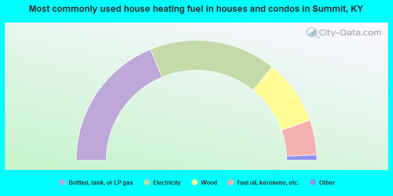
- 37.5%Bottled, tank, or LP gas
- 34.1%Electricity
- 17.6%Wood
- 9.4%Fuel oil, kerosene, etc.
- 0.8%Utility gas
- 0.7%Other fuel
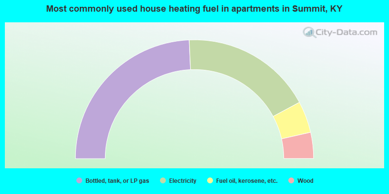
- 48.6%Bottled, tank, or LP gas
- 35.7%Electricity
- 8.6%Fuel oil, kerosene, etc.
- 7.1%Wood
Summit compared to Kentucky state average:
- Unemployed percentage below state average.
- Black race population percentage significantly below state average.
- Hispanic race population percentage significantly below state average.
- Foreign-born population percentage significantly below state average.
- Renting percentage below state average.
- Length of stay since moving in significantly above state average.
- Number of rooms per house significantly below state average.
- House age significantly below state average.
- Percentage of population with a bachelor's degree or higher below state average.