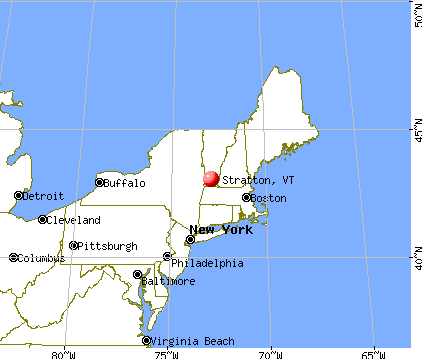
Stratton, Vermont
Submit your own pictures of this town and show them to the world
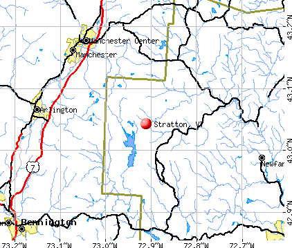
- OSM Map
- General Map
- Google Map
- MSN Map
Population change since 2000: +58.8%
| Males: 112 | |
| Females: 104 |
| Median resident age: | 46.7 years |
| Vermont median age: | 45.8 years |
Zip code: 05155
| Stratton: | $67,995 |
| VT: | $73,991 |
Estimated per capita income in 2022: $64,614 (it was $32,489 in 2000)
Estimated median house or condo value in 2022: $310,992 (it was $125,000 in 2000)
| Stratton: | $310,992 |
| VT: | $304,700 |
Mean prices in 2022: all housing units: $298,935; detached houses: $317,292; townhouses or other attached units: $299,018; in 2-unit structures: $292,940; in 3-to-4-unit structures: $427,770; in 5-or-more-unit structures: $214,034; mobile homes: $65,502


- 21398.6%White alone
- 10.5%American Indian alone
- 10.5%Native Hawaiian and Other
Pacific Islander alone - 10.5%Two or more races

 Recent articles from our blog. Our writers, many of them Ph.D. graduates or candidates, create easy-to-read articles on a wide variety of topics.

 | Southern Vermont Retirement Advice! Thank you! (22 replies) |
| Mountain Family considering moving from CO to VT (52 replies) |
| Stratton Mountain in Summer (7 replies) |
| Which Home Inspector in Stratton / Manchester, Vermont (3 replies) |
| Mad River Valley? Questions on possible relocation... (30 replies) |
| Vermont Weather (3779 replies) |
Latest news from Stratton, VT collected exclusively by city-data.com from local newspapers, TV, and radio stations
Ancestries: English (19.9%), German (16.2%), Italian (13.2%), Irish (11.8%), French (8.1%), Scottish (8.1%).
Current Local Time: EST time zone
Elevation: 1941 feet
Land area: 46.4 square miles.
Population density: 4.7 people per square mile (very low).
21 residents are foreign born (7.4% Europe, 5.9% Oceania, 2.2% Asia).
| This town: | 15.4% |
| Vermont: | 3.8% |
| Stratton town: | 1.1% ($1,406) |
| Vermont: | 2.0% ($2,196) |
Nearest city with pop. 50,000+: Albany, NY  (52.4 miles , pop. 95,658).
Nearest city with pop. 200,000+: Boston, MA (105.5 miles , pop. 589,141).
Nearest city with pop. 1,000,000+: Bronx, NY (161.1 miles , pop. 1,332,650).
Nearest cities:
), ), ), ), Latitude: 43.06 N, Longitude: 72.90 W
Area code commonly used in this area: 802


Single-family new house construction building permits:
- 2022: 8 buildings, average cost: $408,800
- 2021: 7 buildings, average cost: $408,800
- 2020: 6 buildings, average cost: $408,800
- 2019: 5 buildings, average cost: $408,800
- 2018: 5 buildings, average cost: $408,800
- 2015: 3 buildings, average cost: $1,317,300
- 2014: 1 building, cost: $450,000
- 2012: 2 buildings, average cost: $475,000
- 2011: 3 buildings, average cost: $576,700
- 2008: 1 building, cost: $3,600,000
- 2007: 1 building, cost: $185,000
- 2006: 5 buildings, average cost: $948,800
- 2005: 2 buildings, average cost: $375,000
- 2004: 16 buildings, average cost: $345,100
- 2003: 13 buildings, average cost: $379,200
- 2002: 106 buildings, average cost: $737,400
- 2001: 97 buildings, average cost: $737,400
- 2000: 9 buildings, average cost: $140,700
- 1999: 6 buildings, average cost: $153,300
- 1998: 6 buildings, average cost: $78,200
- 1997: 5 buildings, average cost: $78,200


| Here: | 0.9% |
| Vermont: | 2.0% |

Average climate in Stratton, Vermont
Based on data reported by over 4,000 weather stations


(lower is better)

Air Quality Index (AQI) level in 2022 was 51.9. This is better than average.
| City: | 51.9 |
| U.S.: | 72.6 |

Ozone [ppb] level in 2022 was 29.1. This is about average. Closest monitor was 15.3 miles away from the city center.
| City: | 29.1 |
| U.S.: | 33.3 |

Particulate Matter (PM2.5) [µg/m3] level in 2022 was 5.56. This is significantly better than average. Closest monitor was 18.9 miles away from the city center.
| City: | 5.56 |
| U.S.: | 8.11 |
Tornado activity:
Stratton-area historical tornado activity is significantly above Vermont state average. It is 41% smaller than the overall U.S. average.
On 8/20/1968, a category F3 (max. wind speeds 158-206 mph) tornado 5.9 miles away from the Stratton town center injured one person and caused between $5000 and $50,000 in damages.
On 5/31/1998, a category F3 tornado 16.7 miles away from the town center injured 68 people and caused $71 million in damages.
Earthquake activity:
Stratton-area historical earthquake activity is significantly above Vermont state average. It is 69% smaller than the overall U.S. average.On 10/7/1983 at 10:18:46, a magnitude 5.3 (5.1 MB, 5.3 LG, 5.1 ML, Class: Moderate, Intensity: VI - VII) earthquake occurred 94.9 miles away from Stratton center
On 4/20/2002 at 10:50:47, a magnitude 5.3 (5.3 ML, Depth: 3.0 mi) earthquake occurred 107.9 miles away from Stratton center
On 4/20/2002 at 10:50:47, a magnitude 5.2 (5.2 MB, 4.2 MS, 5.2 MW, 5.0 MW) earthquake occurred 106.7 miles away from Stratton center
On 1/19/1982 at 00:14:42, a magnitude 4.7 (4.5 MB, 4.7 MD, 4.5 LG, Class: Light, Intensity: IV - V) earthquake occurred 72.3 miles away from the city center
On 10/16/2012 at 23:12:25, a magnitude 4.7 (4.7 ML, Depth: 10.0 mi) earthquake occurred 119.0 miles away from the city center
On 6/17/1991 at 08:53:16, a magnitude 4.1 (4.0 MB, 4.0 LG, Depth: 3.1 mi) earthquake occurred 94.8 miles away from Stratton center
Magnitude types: regional Lg-wave magnitude (LG), body-wave magnitude (MB), duration magnitude (MD), local magnitude (ML), surface-wave magnitude (MS), moment magnitude (MW)
Natural disasters:
The number of natural disasters in Windham County (16) is near the US average (15).Major Disasters (Presidential) Declared: 13
Emergencies Declared: 2
Causes of natural disasters: Floods: 11, Storms: 10, Tropical Storms: 2, Hurricane: 1, Landslide: 1, Snowstorm: 1, Wind: 1, Winter Storm: 1 (Note: some incidents may be assigned to more than one category).
Colleges/universities with over 2000 students nearest to Stratton:
- Williams College (about 29 miles; Williamstown, MA; Full-time enrollment: 2,141)
- Keene State College (about 33 miles; Keene, NH; FT enrollment: 5,098)
- Castleton State College (about 41 miles; Castleton, VT; FT enrollment: 2,079)
- Adirondack Community College (about 43 miles; Queensbury, NY; FT enrollment: 2,826)
- SUNY Empire State College (about 45 miles; Saratoga Springs, NY; FT enrollment: 9,473)
- Skidmore College (about 45 miles; Saratoga Springs, NY; FT enrollment: 2,753)
- Rensselaer Polytechnic Institute (about 46 miles; Troy, NY; FT enrollment: 6,940)
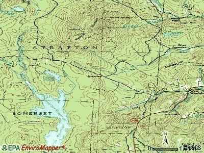
Points of interest:
Notable locations in Stratton: Stratton Mountain Camp (A), Vondell Shelter (B), Stratton View Shelter (C), Grout Pond Recreation Site (D), Bigelow Shelter (E), Stratton Mountain Winter Sports Area (F), Willis Ross Camp (G), Webster Shelter (H), Stratton Mountain Volunteer Fire Company (I), Stratton Mountain Volunteer Fire Company - Town Garage (J). Display/hide their locations on the map
Church in Stratton: Chapel of the Snows (A). Display/hide its location on the map
Cemeteries: North Cemetery (1), Pike Cemetery (2), Ball Cemetery (3), Willis Cemetery (4), Eddy Cemetery (5). Display/hide their locations on the map
Lakes and reservoirs: Stratton Pond (A), Grout Pond (B), Gulf Brook Reservoir (C). Display/hide their locations on the map
Streams, rivers, and creeks: Black Brook (A). Display/hide its location on the map
Park in Stratton: Daniel Webster Historical Monument (1). Display/hide its location on the map
| This town: | 2.2 people |
| Vermont: | 2.3 people |
| This town: | 63.3% |
| Whole state: | 62.5% |
| This town: | 3.1% |
| Whole state: | 9.2% |
Likely homosexual households (counted as self-reported same-sex unmarried-partner households)
- Lesbian couples: 1.0% of all households
- Gay men: 0.0% of all households
| This town: | 5.0% |
| Whole state: | 9.4% |
| This town: | 2.9% |
| Whole state: | 3.6% |
For population 15 years and over in Stratton:

- Never married: 30.4%
- Now married: 54.4%
- Separated: 0.0%
- Widowed: 6.4%
- Divorced: 8.8%
For population 25 years and over in Stratton:
- High school or higher: 92.8%
- Bachelor's degree or higher: 45.9%
- Graduate or professional degree: 14.4%
- Mean travel time to work (commute): 14.8 minutes


| Here: | 9.3 |
| Vermont average: | 11.7 |
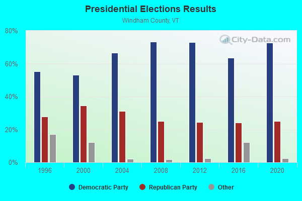
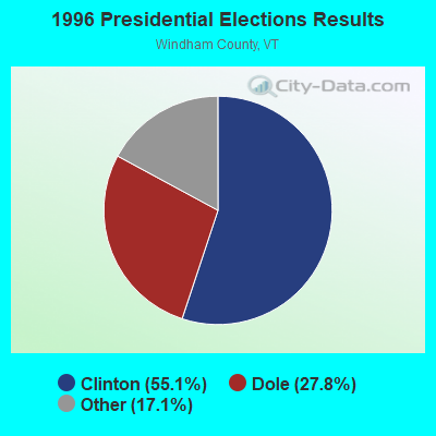
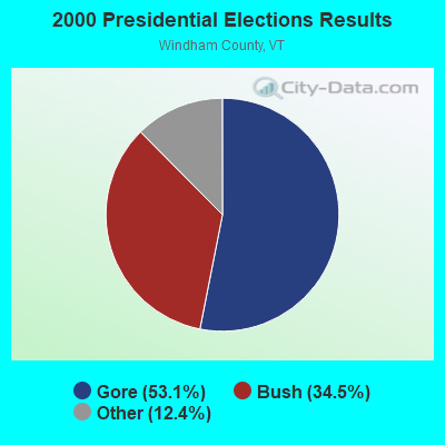
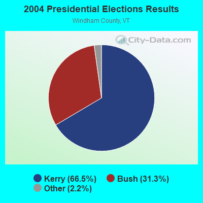
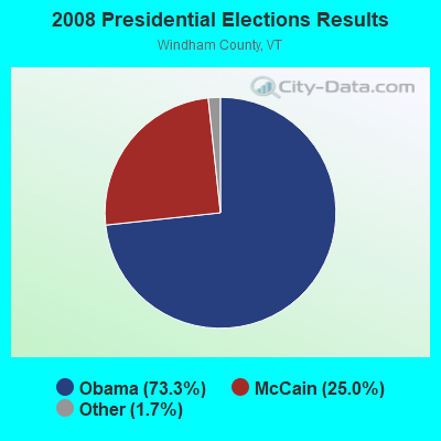

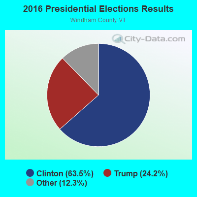
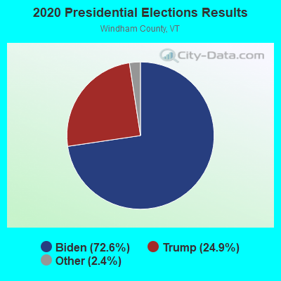
Graphs represent county-level data. Detailed 2008 Election Results
Religion statistics for Stratton, VT (based on Windham County data)
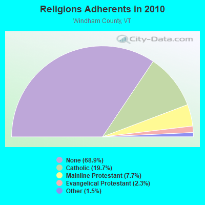
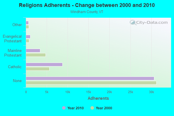
| Religion | Adherents | Congregations |
|---|---|---|
| Catholic | 8,753 | 8 |
| Mainline Protestant | 3,412 | 38 |
| Evangelical Protestant | 1,026 | 13 |
| Other | 647 | 12 |
| None | 30,675 | - |
Food Environment Statistics:
| Here: | 4.14 / 10,000 pop. |
| Vermont: | 3.84 / 10,000 pop. |
| This county: | 1.38 / 10,000 pop. |
| State: | 1.95 / 10,000 pop. |
| Windham County: | 7.37 / 10,000 pop. |
| Vermont: | 6.40 / 10,000 pop. |
| Windham County: | 18.87 / 10,000 pop. |
| State: | 11.52 / 10,000 pop. |
| Windham County: | 6.7% |
| Vermont: | 6.8% |
| This county: | 22.6% |
| Vermont: | 22.3% |
| Windham County: | 12.5% |
| State: | 13.3% |
Strongest AM radio stations in Stratton:
- WNNZ (640 AM; 50 kW; WESTFIELD, MA; Owner: CLEAR CHANNEL BROADCASTING LICENSES, INC.)
- WGY (810 AM; 50 kW; SCHENECTADY, NY; Owner: CLEAR CHANNEL BROADCASTING LICENSES, INC.)
- WPTR (1540 AM; 50 kW; ALBANY, NY; Owner: KIMTRON, INC.)
- WCRN (830 AM; 50 kW; WORCESTER, MA; Owner: CARTER BROADCASTING CORPORATION)
- WRKO (680 AM; 50 kW; BOSTON, MA; Owner: ENTERCOM BOSTON LICENSE, LLC)
- WVNE (760 AM; daytime; 25 kW; LEICESTER, MA; Owner: BLOUNT MASSCOM, INC.)
- WTIC (1080 AM; 50 kW; HARTFORD, CT; Owner: INFINITY RADIO OPERATIONS INC.)
- WEEI (850 AM; 50 kW; BOSTON, MA; Owner: ENTERCOM BOSTON LICENSE, LLC)
- WNTK (1020 AM; 10 kW; NEWPORT, NH; Owner: KOOR COMMUNICATIONS, INC.)
- WIZZ (1520 AM; daytime; 10 kW; GREENFIELD, MA; Owner: P. & M. RADIO, LLC)
- WNBX (1480 AM; 5 kW; SPRINGFIELD, VT)
- WKOX (1200 AM; 50 kW; FRAMINGHAM, MA; Owner: CAPSTAR TX LIMITED PARTNERSHIP)
- WALE (990 AM; 50 kW; GREENVILLE, RI; Owner: NORTH AMERICAN BROADCASTING CO., INC.)
Strongest FM radio stations in Stratton:
- WVAY (100.7 FM; WILMINGTON, VT; Owner: GREAT NORTHERN RADIO, L.L.C.)
- WEQX (102.7 FM; MANCHESTER, VT; Owner: NORTHSHIRE COMMUNICATIONS, INC.)
- WJAN (95.1 FM; SUNDERLAND, VT; Owner: 6 JOHNSON ROAD LICENSES, INC.)
- WJJR (98.1 FM; RUTLAND, VT; Owner: 6 JOHNSON ROAD LICENSES, INC.)
- WZRT (97.1 FM; RUTLAND, VT; Owner: CAPSTAR TX LIMITED PARTNERSHIP)
- WAMC-FM (90.3 FM; ALBANY, NY; Owner: WAMC)
- WVPR (89.5 FM; WINDSOR, VT; Owner: VERMONT PUBLIC RADIO)
- WEBK (105.3 FM; KILLINGTON, VT; Owner: 6 JOHNSON ROAD LICENSES, INC.)
- WCMK (91.9 FM; PUTNEY, VT; Owner: CHRISTIAN MINISTRIES INC)
- WHDQ (106.1 FM; CLAREMONT, NH; Owner: GREAT NORTHERN RADIO, L.L.C.)
- WGLV (91.7 FM; WOODSTOCK, VT; Owner: CHRISTIAN MINISTRIES INC)
- WHDQ-FM1 (106.1 FM; RUTLAND, VT; Owner: GREAT NORTHERN RADIO, L.L.C.)
- WRSY (101.5 FM; MARLBORO, VT; Owner: GREAT NORTHERN RADIO, L.L.C.)
- WKVT-FM (92.7 FM; BRATTLEBORO, VT; Owner: SAGA COMMUNICATIONS OF NEW ENGLAND, LLC)
- WNGN (91.9 FM; ARGYLE, NY; Owner: NORTHEAST GOSPEL BROADCASTING INC)
- WKNE (103.7 FM; KEENE, NH; Owner: SAGA COMMUNICATIONS OF NEW ENGLAND, LLC)
- WZEC (97.5 FM; HOOSICK FALLS, NY; Owner: GREAT NORTHERN RADIO, LLC)
- WEVN (90.7 FM; KEENE, NH; Owner: NEW HAMPSHIRE PUBLIC RADIO, INC.)
- WCFR-FM (96.3 FM; WALPOLE, NH; Owner: GREAT NORTHERN RADIO, LLC)
- W284AB (104.7 FM; JAMAICA, VT; Owner: GREAT NORTHERN RADIO, L.L.C.)
TV broadcast stations around Stratton:
- WEKW-TV (Channel 52; KEENE, NH; Owner: UNIVERSITY OF NEW HAMPSHIRE)
- National Bridge Inventory (NBI) Statistics
- 5Number of bridges
- 13ft / 4.0mTotal length
- 754Total average daily traffic
- 38Total average daily truck traffic
- 794Total future (year 2027) average daily traffic
FCC Registered Cell Phone Towers:
1- Stratton Cell Site 3.4 Miles Ssw Of Bondville On Stratton Mountain (Lat: 43.105361 Lon: -72.911778), Structure height: 18.3 m, Call Sign: KNKQ277
Assigned Frequencies: 880.020 MHz, 891.510 MHz, 835.020 MHz, 846.510 MHzGrant Date: 09/08/2021, Expiration Date: 10/01/2031Registrant: Wilkinson Barker Knauer, LLP, 1800 M Street Nw, Suite 800n, Washington, DC 20036, Phone: (202) 383-3420, Fax: (202) 783-5851, Email:
FCC Registered Paging Towers:
1- Stratton Mountain (Lat: 43.096750 Lon: -72.919556), Structure height: 6.7 m, Overall height: 24.4 m, Call Sign: KDS417,
Assigned Frequencies: 152.030 MHz, 459.525 MHz, Grant Date: 04/02/2019, Expiration Date: 04/01/2029, Certifier: Gerald W Blanchard, Registrant: Keller And Heckman LLP, 1001 G Street Nw, Suite 500 West, Washington, DC 20001, Phone: (202) 434-4100, Fax: (202) 434-4646, Email:
Stratton compared to Vermont state average:
- Unemployed percentage significantly below state average.
- Black race population percentage significantly below state average.
- Hispanic race population percentage significantly below state average.
- Foreign-born population percentage significantly above state average.
- Length of stay since moving in significantly above state average.
- Number of rooms per house significantly below state average.
- House age significantly below state average.
State forum archive: