Stewartsville, Missouri
Submit your own pictures of this city and show them to the world
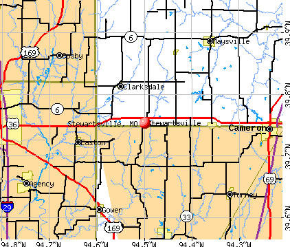
- OSM Map
- General Map
- Google Map
- MSN Map
Population change since 2000: -2.5%
 |
| Males: 347 | |
| Females: 393 |
| Median resident age: | 26.4 years |
| Missouri median age: | 39.1 years |
Zip codes: 64490.
| Stewartsville: | $69,847 |
| MO: | $64,811 |
Estimated per capita income in 2022: $23,953 (it was $14,509 in 2000)
Stewartsville city income, earnings, and wages data
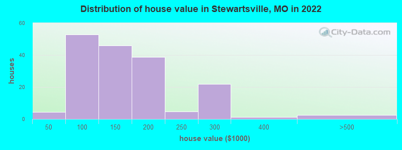
Estimated median house or condo value in 2022: $132,897 (it was $63,100 in 2000)
| Stewartsville: | $132,897 |
| MO: | $221,200 |
Mean prices in 2022: all housing units: $136,972; detached houses: $151,804; mobile homes: $55,396
Median gross rent in 2022: $722.
(10.5% for White Non-Hispanic residents, 14.0% for Hispanic or Latino residents, 100.0% for American Indian residents)
Detailed information about poverty and poor residents in Stewartsville, MO
Compare current foreclosures near Stewartsville, MO:
| Photo | Address | Area | Beds / Baths | Price | Details |
|---|---|---|---|---|---|

|
#1
SW Spruce Rd
Stewartsville, MO 64490
|
- sq. feet
|
- baths 3 beds |
show details | |

|
#2
SW Highway 36
Stewartsville, MO 64490
|
- sq. feet
|
- baths 2 beds |
show details | |

|
#3
Kennedy Dr
Gower, MO 64454
|
991 sq. feet
|
1 baths 3 beds |
show details | |

|
#4
N Heatherwood Dr
Saint Joseph, MO 64506
|
- sq. feet
|
2 baths 3 beds |
show details | |

|
#5
Candleberry Dr
Saint Joseph, MO 64503
|
1,469 sq. feet
|
1 baths 3 beds |
show details | |

|
#6
Harrington Ln
Gower, MO 64454
|
2,648 sq. feet
|
2 baths 3 beds |
show details | |

|
#7
N 6th St
Cosby, MO 64436
|
1,050 sq. feet
|
1 baths 3 beds |
show details | |

|
#8
Winding Creek Ln
Cameron, MO 64429
|
- sq. feet
|
2 baths 3 beds |
show details | |

|
#9
W 3rd St
Cameron, MO 64429
|
1 sq. feet
|
1 baths 2 beds |
show details | |

|
#10
County Road 301
Saint Joseph, MO 64507
|
2,645 sq. feet
|
1 baths - beds |
show details |
| Photo | Address | Area | Beds / Baths | Price | Details |
|---|---|---|---|---|---|

|
#11
NW Highway 36
Cameron, MO 64429
|
- sq. feet
|
- baths - beds |
show details | |

|
#12
Corinth Dr
Saint Joseph, MO 64506
|
- sq. feet
|
- baths - beds |
show details | |

|
#13
Carol Dr
Saint Joseph, MO 64506
|
- sq. feet
|
- baths - beds |
show details | |

|
#14
Faraon St Apt F
Saint Joseph, MO 64506
|
- sq. feet
|
- baths - beds |
show details | |

|
#15
NW Sale Barn Rd
Cameron, MO 64429
|
- sq. feet
|
- baths - beds |
show details | |

|
#16
SE Frost Rd
Cameron, MO 64429
|
- sq. feet
|
- baths 3 beds |
show details | |

|
#17
Juniper Ln
Saint Joseph, MO 64503
|
- sq. feet
|
- baths - beds |
show details | |

|
#18
Locust St
Saint Joseph, MO 64501
|
- sq. feet
|
- baths - beds |
show details | |

|
#19
Chatham Ave
Saint Joseph, MO 64506
|
- sq. feet
|
- baths - beds |
show details | |

|
#20
Pacific St
Saint Joseph, MO 64507
|
- sq. feet
|
- baths - beds |
show details |
| Photo | Address | Area | Beds / Baths | Price | Details |
|---|---|---|---|---|---|

|
#21
Gene Field Rd Apt H09
Saint Joseph, MO 64506
|
- sq. feet
|
- baths - beds |
show details | |

|
#22
Faraon St, Bldg
Saint Joseph, MO 64506
|
- sq. feet
|
- baths - beds |
show details | |

|
#23
Morningside Dr
Saint Joseph, MO 64503
|
- sq. feet
|
- baths - beds |
show details | |

|
#24
Concha St, Unit C
Lathrop, MO 64465
|
- sq. feet
|
- baths - beds |
show details | |

|
#25
E 2nd St
Cameron, MO 64429
|
- sq. feet
|
- baths - beds |
show details | |

|
#26
Coach Light Pl
Saint Joseph, MO 64503
|
- sq. feet
|
- baths - beds |
show details | |

|
#27
Brookside St
Saint Joseph, MO 64506
|
- sq. feet
|
- baths - beds |
show details | |

|
#28
Gene Field Rd Apt 25
Saint Joseph, MO 64506
|
- sq. feet
|
- baths - beds |
show details | |

|
#29
1/2 Cook Rd
Saint Joseph, MO 64505
|
- sq. feet
|
- baths - beds |
show details | |

|
#30
S Leonard Rd Apt 42
Saint Joseph, MO 64503
|
- sq. feet
|
- baths - beds |
show details |
| Photo | Address | Area | Beds / Baths | Price | Details |
|---|---|---|---|---|---|

|
#31
Cameron Villa Dr Apt C-13
Cameron, MO 64429
|
- sq. feet
|
- baths - beds |
show details | |

|
#32
N Pine St
Cameron, MO 64429
|
- sq. feet
|
- baths 3 beds |
show details | |

|
#33
Highland St
Maysville, MO 64469
|
- sq. feet
|
- baths - beds |
show details | |

|
#34
S Riverside Rd Apt B1
Saint Joseph, MO 64507
|
- sq. feet
|
- baths - beds |
show details | |

|
#35
W 3rd St
Cameron, MO 64429
|
- sq. feet
|
- baths - beds |
show details | |

|
#36
N Harris St
Cameron, MO 64429
|
- sq. feet
|
- baths - beds |
show details | |

|
#37
W Concord Dr Apt F
Plattsburg, MO 64477
|
- sq. feet
|
- baths - beds |
show details | |

|
#38
S Harris St
Cameron, MO 64429
|
- sq. feet
|
- baths - beds |
show details | |

|
#39
SE Grindstone Rd
Cameron, MO 64429
|
- sq. feet
|
- baths 3 beds |
show details | |

|
#40
S Chestnut St
Cameron, MO 64429
|
- sq. feet
|
- baths - beds |
show details |
| Photo | Address | Area | Beds / Baths | Price | Details |
|---|---|---|---|---|---|

|
#41
E Evergreen St
Cameron, MO 64429
|
- sq. feet
|
- baths - beds |
show details | |

|
#42
E 14th Ter
Cameron, MO 64429
|
- sq. feet
|
- baths 4 beds |
show details | |

|
#43
Us Highway 36
Easton, MO 64443
|
- sq. feet
|
- baths - beds |
show details | |

|
#44
S 33rd Ter
Saint Joseph, MO 64503
|
- sq. feet
|
- baths - beds |
show details | |

|
#45
Duncan St
Saint Joseph, MO 64507
|
- sq. feet
|
- baths - beds |
show details | |

|
#46
N 3rd St
Clarksdale, MO 64430
|
- sq. feet
|
- baths - beds |
show details | |

|
#47
Penn St
Saint Joseph, MO 64507
|
- sq. feet
|
- baths - beds |
show details | |

|
#48
Pear St
Saint Joseph, MO 64503
|
- sq. feet
|
- baths - beds |
show details | |

|
#49
Orchard Ln
Saint Joseph, MO 64501
|
- sq. feet
|
- baths - beds |
show details | |

|
Check over 1 million property listings on Foreclosure.com!
|
browse all offers | |||


- 65385.9%White alone
- 445.8%Hispanic
- 415.4%Black alone
- 162.1%Two or more races

Races in Stewartsville detailed stats: ancestries, foreign born residents, place of birth
According to our research of Missouri and other state lists, there were 3 registered sex offenders living in Stewartsville, Missouri as of May 22, 2024.
The ratio of all residents to sex offenders in Stewartsville is 289 to 1.
The ratio of registered sex offenders to all residents in this city is near the state average.
Type |
2009 |
2010 |
2011 |
2012 |
2019 |
|---|---|---|---|---|---|
| Murders (per 100,000) | 0 (0.0) | 0 (0.0) | 0 (0.0) | 0 (0.0) | 0 (0.0) |
| Rapes (per 100,000) | 0 (0.0) | 0 (0.0) | 0 (0.0) | 0 (0.0) | 0 (0.0) |
| Robberies (per 100,000) | 0 (0.0) | 0 (0.0) | 0 (0.0) | 0 (0.0) | 0 (0.0) |
| Assaults (per 100,000) | 0 (0.0) | 0 (0.0) | 0 (0.0) | 0 (0.0) | 1 (135.3) |
| Burglaries (per 100,000) | 0 (0.0) | 0 (0.0) | 1 (132.8) | 0 (0.0) | 1 (135.3) |
| Thefts (per 100,000) | 4 (540.5) | 1 (133.3) | 0 (0.0) | 1 (135.1) | 4 (541.3) |
| Auto thefts (per 100,000) | 0 (0.0) | 0 (0.0) | 0 (0.0) | 0 (0.0) | 3 (406.0) |
| Arson (per 100,000) | 0 (0.0) | 0 (0.0) | 0 (0.0) | 0 (0.0) | 0 (0.0) |
| City-Data.com crime index | 21.6 | 5.3 | 9.3 | 5.4 | 90.7 |
The City-Data.com crime index weighs serious crimes and violent crimes more heavily. Higher means more crime, U.S. average is 246.1. It adjusts for the number of visitors and daily workers commuting into cities.

Crime rate in Stewartsville detailed stats: murders, rapes, robberies, assaults, burglaries, thefts, arson
Full-time law enforcement employees in 2019, including police officers: 1 (1 officers - 1 male; 0 female).
| Officers per 1,000 residents here: | 1.35 |
| Missouri average: | 2.48 |
 Recent articles from our blog. Our writers, many of them Ph.D. graduates or candidates, create easy-to-read articles on a wide variety of topics.

 | Missouri Outlaw History (3407 replies) |
Latest news from Stewartsville, MO collected exclusively by city-data.com from local newspapers, TV, and radio stations
Ancestries: American (30.2%), German (21.4%), English (13.5%), Irish (8.3%), European (2.0%).
Current Local Time: CST time zone
Incorporated in 1869
Elevation: 958 feet
Land area: 0.97 square miles.
Population density: 760 people per square mile (low).
1 resident is foreign born
| This city: | 0.1% |
| Missouri: | 4.2% |
| Stewartsville city: | 0.8% ($493) |
| Missouri: | 1.0% ($851) |
Nearest city with pop. 50,000+: St. Joseph, MO  (18.0 miles , pop. 73,990).
Nearest city with pop. 200,000+: Kansas City, MO (46.9 miles , pop. 441,545).
Nearest city with pop. 1,000,000+: Chicago, IL (385.0 miles , pop. 2,896,016).
Nearest cities:
), ), ), ), Latitude: 39.75 N, Longitude: 94.50 W
Area code: 816


Single-family new house construction building permits:
- 2016: 4 buildings, average cost: $45,000
- 2015: 1 building, cost: $80,000
- 2014: 1 building, cost: $235,400
- 2013: 1 building, cost: $75,000
- 2007: 1 building, cost: $55,000
- 2006: 4 buildings, average cost: $73,800
- 2005: 5 buildings, average cost: $75,500
- 2004: 3 buildings, average cost: $114,300
- 2003: 4 buildings, average cost: $87,500
- 2002: 4 buildings, average cost: $116,300


| Here: | 2.5% |
| Missouri: | 2.8% |
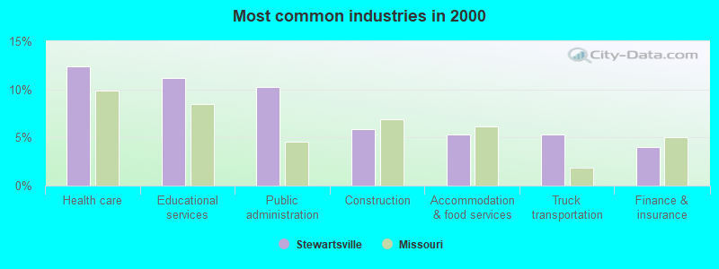
- Health care (12.4%)
- Educational services (11.2%)
- Public administration (10.2%)
- Construction (5.9%)
- Accommodation & food services (5.3%)
- Truck transportation (5.3%)
- Finance & insurance (4.0%)
- Public administration (14.1%)
- Truck transportation (10.0%)
- Construction (8.8%)
- Agriculture, forestry, fishing & hunting (5.9%)
- Machinery (5.9%)
- Educational services (5.3%)
- Rail transportation (4.7%)
- Health care (23.7%)
- Educational services (17.8%)
- Accommodation & food services (9.9%)
- Finance & insurance (8.6%)
- Public administration (5.9%)
- Social assistance (4.6%)
- Department & other general merchandise stores (3.3%)
- Law enforcement workers, including supervisors (6.2%)
- Driver/sales workers and truck drivers (5.9%)
- Preschool, kindergarten, elementary, and middle school teachers (4.7%)
- Other management occupations, except farmers and farm managers (4.3%)
- Other office and administrative support workers, including supervisors (4.3%)
- Nursing, psychiatric, and home health aides (4.0%)
- Other production occupations, including supervisors (3.7%)

- Driver/sales workers and truck drivers (11.2%)
- Law enforcement workers, including supervisors (8.8%)
- Farmers and farm managers (5.9%)
- Other production occupations, including supervisors (5.9%)
- Vehicle and mobile equipment mechanics, installers, and repairers (5.9%)
- Other management occupations, except farmers and farm managers (4.1%)
- Engineers (3.5%)
- Nursing, psychiatric, and home health aides (8.6%)
- Other office and administrative support workers, including supervisors (7.9%)
- Preschool, kindergarten, elementary, and middle school teachers (7.2%)
- Waiters and waitresses (6.6%)
- Registered nurses (5.3%)
- Other management occupations, except farmers and farm managers (4.6%)
- Cashiers (4.6%)
Average climate in Stewartsville, Missouri
Based on data reported by over 4,000 weather stations


(lower is better)
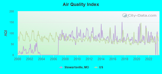
Air Quality Index (AQI) level in 2022 was 75.7. This is about average.
| City: | 75.7 |
| U.S.: | 72.6 |
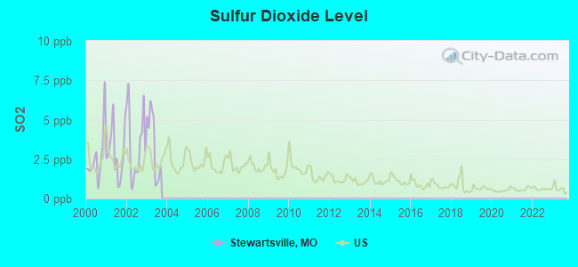
Sulfur Dioxide (SO2) [ppb] level in 2003 was 3.49. This is significantly worse than average. Closest monitor was 19.2 miles away from the city center.
| City: | 3.49 |
| U.S.: | 1.51 |
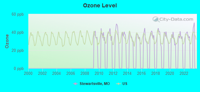
Ozone [ppb] level in 2022 was 37.3. This is about average. Closest monitor was 19.2 miles away from the city center.
| City: | 37.3 |
| U.S.: | 33.3 |
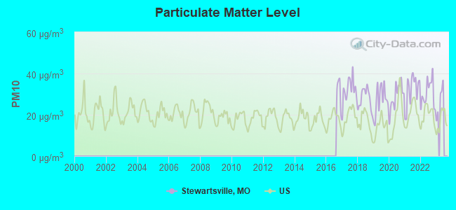
Particulate Matter (PM10) [µg/m3] level in 2022 was 30.2. This is significantly worse than average. Closest monitor was 19.2 miles away from the city center.
| City: | 30.2 |
| U.S.: | 19.2 |
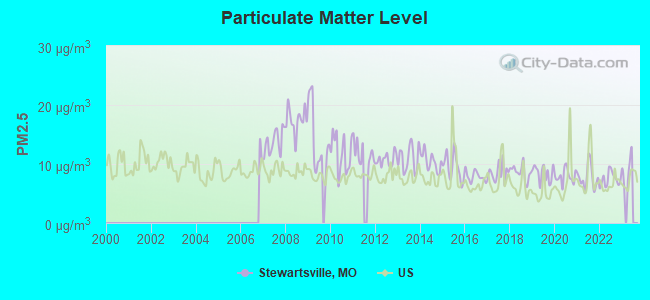
Particulate Matter (PM2.5) [µg/m3] level in 2022 was 7.40. This is about average. Closest monitor was 18.5 miles away from the city center.
| City: | 7.40 |
| U.S.: | 8.11 |
Tornado activity:
Stewartsville-area historical tornado activity is slightly above Missouri state average. It is 92% greater than the overall U.S. average.
On 5/29/2004, a category F4 (max. wind speeds 207-260 mph) tornado 15.9 miles away from the Stewartsville city center killed 3 people and injured 6 people and caused $300,000 in damages.
On 4/23/1975, a category F4 tornado 28.4 miles away from the city center killed one person and injured 3 people and caused between $500,000 and $5,000,000 in damages.
Earthquake activity:
Stewartsville-area historical earthquake activity is significantly above Missouri state average. It is 431% greater than the overall U.S. average.On 9/3/2016 at 12:02:44, a magnitude 5.8 (5.8 MW, Depth: 3.5 mi, Class: Moderate, Intensity: VI - VII) earthquake occurred 265.4 miles away from the city center
On 11/6/2011 at 03:53:10, a magnitude 5.7 (5.7 MW, Depth: 3.2 mi) earthquake occurred 317.2 miles away from Stewartsville center
On 11/12/2014 at 21:40:00, a magnitude 4.9 (4.9 MW, Depth: 2.5 mi, Class: Light, Intensity: IV - V) earthquake occurred 240.8 miles away from Stewartsville center
On 11/7/2016 at 01:44:24, a magnitude 5.0 (5.0 MW, Depth: 2.8 mi) earthquake occurred 289.0 miles away from the city center
On 4/18/2008 at 09:36:59, a magnitude 5.4 (5.1 MB, 4.8 MS, 5.4 MW, 5.2 MW) earthquake occurred 366.1 miles away from the city center
On 2/13/2016 at 17:07:06, a magnitude 5.1 (5.1 MW, Depth: 5.2 mi) earthquake occurred 321.5 miles away from the city center
Magnitude types: body-wave magnitude (MB), surface-wave magnitude (MS), moment magnitude (MW)
Natural disasters:
The number of natural disasters in DeKalb County (21) is greater than the US average (15).Major Disasters (Presidential) Declared: 15
Emergencies Declared: 5
Causes of natural disasters: Floods: 11, Storms: 11, Tornadoes: 6, Winter Storms: 5, Drought: 1, Heavy Rain: 1, Hurricane: 1, Ice Storm: 1, Snowstorm: 1, Wind: 1, Other: 1 (Note: some incidents may be assigned to more than one category).

Hospitals and medical centers near Stewartsville:
- SUNSET HOME (Nursing Home, about 12 miles away; MAYSVILLE, MO)
- QUAIL RUN HEALTH CARE CENTER (Nursing Home, about 13 miles away; CAMERON, MO)
- CAMERON REGIONAL MEDICAL CENTER HOME HEALTH AGENCY (Home Health Center, about 14 miles away; CAMERON, MO)
- CAMERON DIALYSIS (Dialysis Facility, about 14 miles away; CAMERON, MO)
- CLINTON CARE AND REHAB CENTER (Nursing Home, about 14 miles away; PLATTSBURG, MO)
- OAKRIDGE OF PLATTSBURG (Nursing Home, about 14 miles away; PLATTSBURG, MO)
- CAMERON NURSING AND REHABILITATION CENTER (Nursing Home, about 14 miles away; CAMERON, MO)
Colleges/universities with over 2000 students nearest to Stewartsville:
- Missouri Western State University (about 16 miles; Saint Joseph, MO; Full-time enrollment: 4,557)
- Grantham University (about 36 miles; Kansas City, MO; FT enrollment: 8,385)
- Park University (about 41 miles; Parkville, MO; FT enrollment: 9,131)
- Highland Community College (about 42 miles; Highland, KS; FT enrollment: 2,148)
- Kansas City Kansas Community College (about 46 miles; Kansas City, KS; FT enrollment: 4,718)
- Northwest Missouri State University (about 47 miles; Maryville, MO; FT enrollment: 5,946)
- Metropolitan Community College-Kansas City (about 48 miles; Kansas City, MO; FT enrollment: 12,834)
Public high school in Stewartsville:
- STEWARTSVILLE HIGH (Students: 137, Location: 902 BUCHANAN ST, Grades: 7-12)
Public elementary/middle school in Stewartsville:
- STEWARTSVILLE ELEM. (Students: 144, Location: 902 BUCHANAN ST, Grades: KG-6)
Points of interest:
Notable location: Stewartsville Fire Protection District (A). Display/hide its location on the map
| This city: | 2.5 people |
| Missouri: | 2.5 people |
| This city: | 70.1% |
| Whole state: | 65.3% |
| This city: | 6.4% |
| Whole state: | 6.7% |
Likely homosexual households (counted as self-reported same-sex unmarried-partner households)
- Lesbian couples: 0.0% of all households
- Gay men: 0.3% of all households
Banks with branches in Stewartsville (2011 data):
- Independent Farmers Bank: Stewartsville Branch at 1303 North Main Street, branch established on 2004/05/03. Info updated 2009/03/04: Bank assets: $105.0 mil, Deposits: $89.2 mil, headquarters in Maysville, MO, positive income, Agricultural Specialization, 5 total offices, Holding Company: Farmers Bancshares, Inc.
- U.S. Bank National Association: Stewartsville Branch at 302 South Main Street, branch established on 1983/04/25. Info updated 2012/01/30: Bank assets: $330,470.8 mil, Deposits: $236,091.5 mil, headquarters in Cincinnati, OH, positive income, 3121 total offices, Holding Company: U.S. Bancorp
For population 15 years and over in Stewartsville:

- Never married: 32.1%
- Now married: 53.7%
- Separated: 2.1%
- Widowed: 4.7%
- Divorced: 7.3%
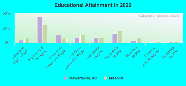
For population 25 years and over in Stewartsville:
- High school or higher: 94.3%
- Bachelor's degree or higher: 19.0%
- Graduate or professional degree: 4.2%
- Unemployed: 7.2%
- Mean travel time to work (commute): 22.4 minutes

| Here: | 8.4 |
| Missouri average: | 11.1 |
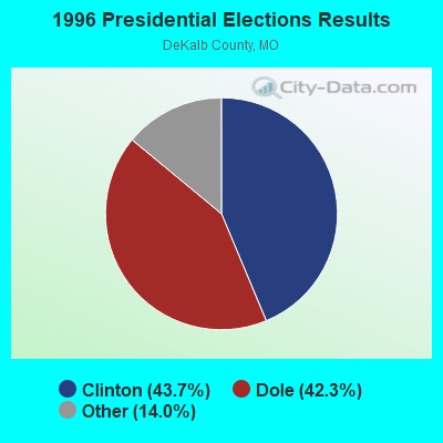
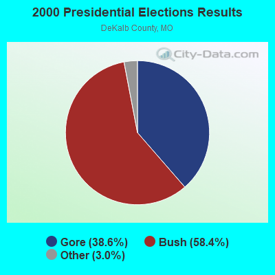

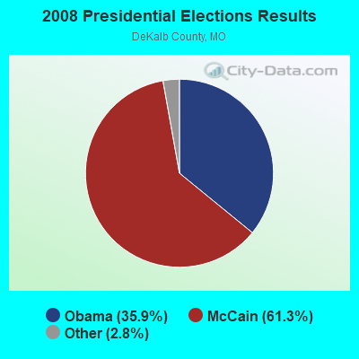
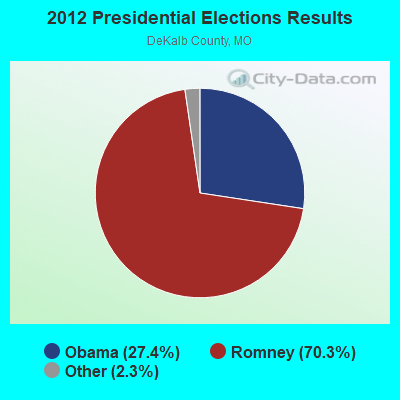


Graphs represent county-level data. Detailed 2008 Election Results
Religion statistics for Stewartsville, MO (based on DeKalb County data)
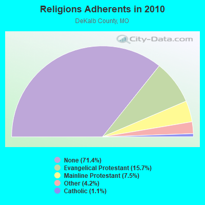
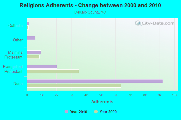
| Religion | Adherents | Congregations |
|---|---|---|
| Evangelical Protestant | 2,027 | 14 |
| Mainline Protestant | 964 | 10 |
| Other | 546 | 3 |
| Catholic | 146 | 1 |
| None | 9,209 | - |
Food Environment Statistics:
| DeKalb County: | 2.46 / 10,000 pop. |
| State: | 1.88 / 10,000 pop. |
| Here: | 0.82 / 10,000 pop. |
| Missouri: | 0.18 / 10,000 pop. |
| DeKalb County: | 4.09 / 10,000 pop. |
| State: | 4.34 / 10,000 pop. |
| This county: | 2.46 / 10,000 pop. |
| Missouri: | 7.37 / 10,000 pop. |
| DeKalb County: | 7.9% |
| State: | 8.8% |
| This county: | 30.7% |
| State: | 29.6% |
| DeKalb County: | 18.0% |
| Missouri: | 13.5% |
Health and Nutrition:
| Stewartsville: | 48.7% |
| Missouri: | 50.9% |
| This city: | 44.6% |
| State: | 48.6% |
| Here: | 30.0 |
| State: | 28.7 |
| This city: | 23.7% |
| State: | 20.6% |
| Stewartsville: | 20.0% |
| Missouri: | 10.1% |
| This city: | 6.8 |
| State: | 6.8 |
| This city: | 41.0% |
| Missouri: | 34.3% |
| Stewartsville: | 53.1% |
| State: | 57.5% |
| Stewartsville: | 77.5% |
| Missouri: | 79.3% |
More about Health and Nutrition of Stewartsville, MO Residents
| Local government employment and payroll (March 2022) | |||||
| Function | Full-time employees | Monthly full-time payroll | Average yearly full-time wage | Part-time employees | Monthly part-time payroll |
|---|---|---|---|---|---|
| Water Supply | 1 | $3,422 | $41,064 | 0 | $0 |
| Other Government Administration | 1 | $3,612 | $43,344 | 0 | $0 |
| Police Protection - Officers | 0 | $0 | 1 | $2,472 | |
| Streets and Highways | 0 | $0 | 3 | $4,598 | |
| Totals for Government | 2 | $7,034 | $42,204 | 4 | $7,070 |
Stewartsville government finances - Expenditure in 2017 (per resident):
- Current Operations - Central Staff Services: $44,000 ($59.46)
Regular Highways: $42,000 ($56.76)
Police Protection: $31,000 ($41.89)
Sewerage: $16,000 ($21.62)
Water Utilities: $16,000 ($21.62)
- Total Salaries and Wages: $150,000 ($202.70)
- Water Utilities - Interest on Debt: $22,000 ($29.73)
Stewartsville government finances - Revenue in 2017 (per resident):
- Charges - Sewerage: $104,000 ($140.54)
Solid Waste Management: $56,000 ($75.68)
Other: $4,000 ($5.41)
- Local Intergovernmental - Highways: $30,000 ($40.54)
Gas Utilities: $1,000 ($1.35)
- Miscellaneous - General Revenue - Other: $3,000 ($4.05)
- Revenue - Water Utilities: $194,000 ($262.16)
- State Intergovernmental - Highways: $30,000 ($40.54)
- Tax - General Sales and Gross Receipts: $133,000 ($179.73)
Property: $53,000 ($71.62)
Public Utilities Sales: $40,000 ($54.05)
Stewartsville government finances - Debt in 2017 (per resident):
- Long Term Debt - Beginning Outstanding - Unspecified Public Purpose: $782,000 ($1056.76)
Outstanding Unspecified Public Purpose: $685,000 ($925.68)
Retired Unspecified Public Purpose: $97,000 ($131.08)
Beginning Outstanding - Public Debt for Private Purpose: $34,000 ($45.95)
Outstanding Nonguaranteed - Industrial Revenue: $28,000 ($37.84)
Retired Nonguaranteed - Public Debt for Private Purpose: $6,000 ($8.11)
Stewartsville government finances - Cash and Securities in 2017 (per resident):
- Other Funds - Cash and Securities: $576,000 ($778.38)
- Sinking Funds - Cash and Securities: $28,000 ($37.84)
Strongest AM radio stations in Stewartsville:
- WHB (810 AM; 50 kW; KANSAS CITY, MO; Owner: UNION BROADCASTING, INC.)
- KFEQ (680 AM; 5 kW; ST. JOSEPH, MO; Owner: EAGLE RADIO, INC.)
- KSFT (1550 AM; 5 kW; ST. JOSEPH, MO; Owner: EAGLE RADIO, INC)
- KCMO (710 AM; 10 kW; KANSAS CITY, MO; Owner: SUSQUEHANNA KANSAS CITY PARTNERSHIP)
- KKHK (1250 AM; 25 kW; KANSAS CITY, KS)
- KOIL (1020 AM; 50 kW; PLATTSMOUTH, NE; Owner: WAITT RADIO, INC.)
- KGNM (1270 AM; 1 kW; ST. JOSEPH, MO)
- KCCV (760 AM; daytime; 6 kW; OVERLAND PARK, KS; Owner: BOTT BROADCASTING COMPANY)
- KCTE (1510 AM; daytime; 10 kW; INDEPENDENCE, MO; Owner: UNION BROADCASTING, INC.)
- KFAB (1110 AM; 50 kW; OMAHA, NE; Owner: CAPSTAR TX LIMITED PARTNERSHIP)
- KCSP (610 AM; 5 kW; KANSAS CITY, MO; Owner: ENTERCOM KANSAS CITY LICENSE, LLC)
- KXTR (1660 AM; 10 kW; KANSAS CITY, KS; Owner: ENTERCOM KANSAS CITY LICENSE, LLC)
- KKAR (1290 AM; 50 kW; OMAHA, NE; Owner: WAITT RADIO, INC.)
Strongest FM radio stations in Stewartsville:
- KKJO-FM (105.5 FM; ST. JOSEPH, MO; Owner: EAGLE RADIO, INC)
- KZPL (97.3 FM; LEE'S SUMMIT, MO; Owner: UNION FIRST BROADCASTING, LLC)
- KSRC (102.1 FM; KANSAS CITY, MO; Owner: INFINITY RADIO OPERATIONS INC.)
- KKWK (100.1 FM; CAMERON, MO; Owner: KAAN, INC.)
- WDAF-FM (106.5 FM; LIBERTY, MO; Owner: ENTERCOM KANSAS CITY LICENSE, LLC)
- K220FX (91.9 FM; ST. JOSEPH, MO; Owner: CALVARY CHAPEL OF TWIN FALLS, INC.)
- KSJQ (92.7 FM; SAVANNAH, MO; Owner: EAGLE RADIO, INC.)
TV broadcast stations around Stewartsville:
- KTAJ (Channel 16; ST. JOSEPH, MO; Owner: TRINITY BROADCASTING NETWORK)
- KQTV (Channel 2; ST. JOSEPH, MO; Owner: NEXSTAR BROADCASTING OF THE MIDWEST, INC.)
- KMBC-TV (Channel 9; KANSAS CITY, MO; Owner: KMBC HEARST-ARGYLE TELEVISION, INC.)
- KCPT (Channel 19; KANSAS CITY, MO; Owner: PUBLIC TELEVISION 19, INC.)
- KSMO-TV (Channel 62; KANSAS CITY, MO; Owner: KSMO LICENSEE, INC.)
- KCWE (Channel 29; KANSAS CITY, MO; Owner: KCWE-TV, INC.)
Stewartsville fatal accident list:
Jun 18, 2000 05:20 AM, Sr-K, Vehicles: 1, Persons: 1, Fatalities: 1, Drunk persons involved: 1
Dec 31, 1998 05:00 PM, Us-36, Vehicles: 2, Persons: 5, Fatalities: 1
Dec 21, 1991 01:30 AM, 36, Vehicles: 1, Persons: 1, Fatalities: 1, Drunk persons involved: 1
Jan 29, 1978 10:55 PM, Vehicles: 2, Persons: 3, Fatalities: 1
- National Bridge Inventory (NBI) Statistics
- 26Number of bridges
- 141ft / 43.4mTotal length
- $957,000Total costs
- 26,483Total average daily traffic
- 7,031Total average daily truck traffic
- 54,535Total future (year 2041) average daily traffic
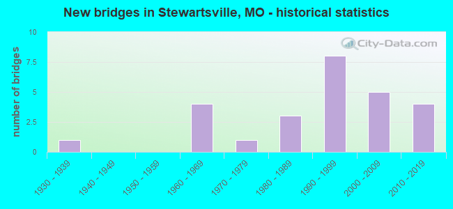
- New bridges - historical statistics
- 11930-1939
- 41960-1969
- 11970-1979
- 31980-1989
- 81990-1999
- 52000-2009
- 42010-2019
FCC Registered Cell Phone Towers:
2 (See the full list of FCC Registered Cell Phone Towers in Stewartsville)FCC Registered Antenna Towers:
27 (See the full list of FCC Registered Antenna Towers)FCC Registered Broadcast Land Mobile Towers:
8 (See the full list of FCC Registered Broadcast Land Mobile Towers in Stewartsville, MO)FCC Registered Microwave Towers:
5- Stewartsville North, Lat: 39.760222 Lon: -94.506583, Type: Tank, Structure height: 45.7 m, Call Sign: WQKW950,
Assigned Frequencies: 3650.00 MHz, Grant Date: 10/14/2009, Expiration Date: 10/14/2019, Cancellation Date: 12/14/2019, Certifier: Ernest L Miller Mr, Registrant: Midwest Mobile Radio Service, 812 South 10 Th Street, St Joseph, MO 64501, Phone: (816) 279-2065, Fax: (816) 233-8862, Email:
- Stewartsville SE, Lat: 39.760222 Lon: -94.506583, Type: Tank, Structure height: 45.7 m, Call Sign: WQKW950,
Assigned Frequencies: 3650.00 MHz, Grant Date: 10/14/2009, Expiration Date: 10/14/2019, Cancellation Date: 12/14/2019, Certifier: Ernest L Miller Mr, Registrant: Midwest Mobile Radio Service, 812 South 10 Th Street, St Joseph, MO 64501, Phone: (816) 279-2065, Fax: (816) 233-8862, Email:
- Stewartsville SW, Lat: 39.760222 Lon: -94.506583, Type: Tank, Structure height: 45.7 m, Call Sign: WQKW950,
Assigned Frequencies: 3650.00 MHz, Grant Date: 10/14/2009, Expiration Date: 10/14/2019, Cancellation Date: 12/14/2019, Certifier: Ernest L Miller Mr, Registrant: Midwest Mobile Radio Service, 812 South 10 Th Street, St Joseph, MO 64501, Phone: (816) 279-2065, Fax: (816) 233-8862, Email:
- STEWARTSVILL, 9535 Sw Sharp Rd (35701) (Lat: 39.768806 Lon: -94.509833), Type: Gtower, Structure height: 122 m, Overall height: 128 m, Call Sign: WQUE607,
Assigned Frequencies: 5945.20 MHz, Grant Date: 06/17/2014, Expiration Date: 06/17/2024, Cancellation Date: 02/04/2021, Certifier: John E Monday, Registrant: At&t Mobility LLC, 208 S Akard St., Rm 1015, Dallas, TX 75202, Phone: (855) 699-7073, Fax: (214) 746-6410, Email:
- MO01212, 9535 Sw Sharp Rd (35701) (Lat: 39.768806 Lon: -94.509833), Type: Gtower, Structure height: 122 m, Overall height: 128 m, Call Sign: WRXL379, Licensee ID: L01973315,
Assigned Frequencies: 10995.0 MHz, 10995.0 MHz, 10995.0 MHz, 10995.0 MHz, 10995.0 MHz, 10995.0 MHz, 10995.0 MHz, 10995.0 MHz, 10995.0 MHz, 10995.0 MHz... (+14 more), Grant Date: 05/26/2023, Expiration Date: 05/26/2033, Certifier: Garrett Wiseman, Registrant: Mercury Wireless Kansas, LLC, 3301 S Kansas Ave, Topeka, KS 66611, Phone: (800) 354-4915, Email:
FCC Registered Amateur Radio Licenses:
16 (See the full list of FCC Registered Amateur Radio Licenses in Stewartsville)2002 - 2018 National Fire Incident Reporting System (NFIRS) incidents
- Fire incident types reported to NFIRS in Stewartsville, MO
- 7541.9%Outside Fires
- 4726.3%Other
- 4525.1%Structure Fires
- 126.7%Mobile Property/Vehicle Fires
 Based on the data from the years 2002 - 2018 the average number of fire incidents per year is 11. The highest number of reported fires - 34 took place in 2009, and the least - 1 in 2014. The data has a declining trend.
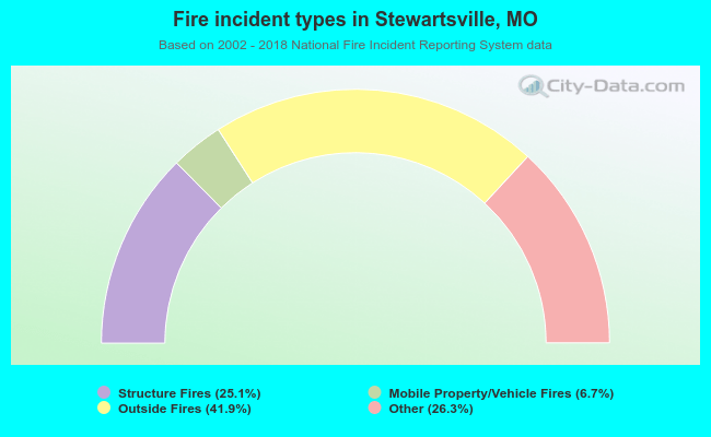 When looking into fire subcategories, the most reports belonged to: Outside Fires (41.9%), and Other (26.3%).
| Most common first names in Stewartsville, MO among deceased individuals | ||
| Name | Count | Lived (average) |
|---|---|---|
| John | 14 | 69.9 years |
| James | 13 | 68.0 years |
| Robert | 13 | 72.7 years |
| Mary | 13 | 71.9 years |
| George | 12 | 82.9 years |
| William | 10 | 78.2 years |
| Charles | 10 | 79.9 years |
| Anna | 7 | 84.0 years |
| Mildred | 7 | 85.3 years |
| Earl | 6 | 78.5 years |
| Most common last names in Stewartsville, MO among deceased individuals | ||
| Last name | Count | Lived (average) |
|---|---|---|
| Kerns | 10 | 83.1 years |
| Smith | 9 | 76.2 years |
| Pickett | 9 | 82.1 years |
| Watson | 8 | 78.2 years |
| Stephens | 8 | 85.2 years |
| Powell | 7 | 85.4 years |
| Gibson | 7 | 76.6 years |
| Baker | 6 | 90.3 years |
| Parton | 6 | 66.0 years |
| Castle | 6 | 81.7 years |
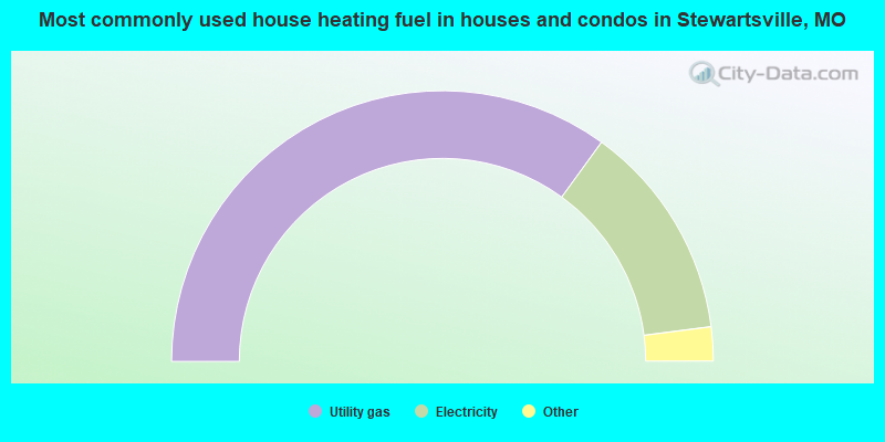
- 70.2%Utility gas
- 26.0%Electricity
- 3.3%Bottled, tank, or LP gas
- 0.6%Wood
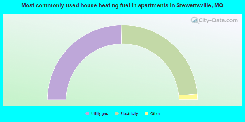
- 50.7%Utility gas
- 49.3%Electricity
Stewartsville compared to Missouri state average:
- Median house value below state average.
- Unemployed percentage below state average.
- Black race population percentage below state average.
- Median age above state average.
- Foreign-born population percentage significantly below state average.
- Length of stay since moving in significantly above state average.
- Number of college students below state average.