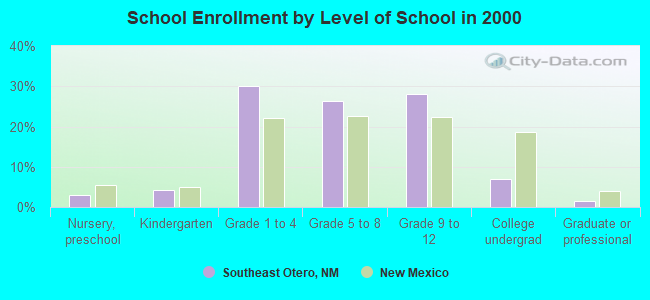
Southeast Otero, New Mexico
Submit your own pictures of this place and show them to the world
- OSM Map
- General Map
- Google Map
- MSN Map

| Males: 4,414 | |
| Females: 4,441 |
| Median resident age: | 36.5 years |
| New Mexico median age: | 34.6 years |
Zip code: 88350
| Southeast Otero: | $49,403 |
| NM: | $59,726 |
Estimated per capita income in 2022: $27,257 (it was $13,353 in 2000)
Southeast Otero CCD income, earnings, and wages data
Estimated median house or condo value in 2022: $191,122 (it was $81,100 in 2000)
| Southeast Otero: | $191,122 |
| NM: | $243,100 |
Southeast Otero, NM residents, houses, and apartments details
Detailed information about poverty and poor residents in Southeast Otero, NM
Compare current foreclosures near your location:
| Photo | Address | Area | Beds / Baths | Price | Details |
|---|---|---|---|---|---|

|
#1
E 21st Ave
Columbus, OH 43211
|
1,061 sq. feet
|
1 baths 3 beds |
$179,900
|
show details |

|
#2
S High St
Columbus, OH 43207
|
1,678 sq. feet
|
2 baths 4 beds |
$31,900
|
show details |

|
#3
Bayberry Cir
Columbus, OH 43207
|
1,564 sq. feet
|
1 baths 3 beds |
$127,500
|
show details |

|
#4
Lehner Rd
Columbus, OH 43224
|
1,628 sq. feet
|
2 baths 4 beds |
show details | |

|
#5
Scottwood Rd
Columbus, OH 43227
|
1,008 sq. feet
|
1 baths 3 beds |
show details | |

|
#6
Grasmere Ave
Columbus, OH 43211
|
720 sq. feet
|
1 baths 2 beds |
show details | |

|
#7
Stoneybrook Blvd # 21a
Hilliard, OH 43026
|
1,231 sq. feet
|
2 baths 3 beds |
show details | |

|
#8
Safford Ave
Columbus, OH 43223
|
784 sq. feet
|
1 baths 2 beds |
show details | |

|
#9
Wrexham Ave
Columbus, OH 43223
|
1,235 sq. feet
|
1 baths 3 beds |
show details | |

|
#10
Meadowbrook Dr
Columbus, OH 43207
|
1,752 sq. feet
|
2 baths 4 beds |
show details |
| Photo | Address | Area | Beds / Baths | Price | Details |
|---|---|---|---|---|---|

|
#11
Hiawatha Park Dr
Columbus, OH 43211
|
1,278 sq. feet
|
1 baths 4 beds |
show details | |

|
#12
Fairfield Ave
Columbus, OH 43203
|
984 sq. feet
|
1 baths 2 beds |
show details | |

|
#13
S Richardson Ave
Columbus, OH 43204
|
1,520 sq. feet
|
2 baths 3 beds |
show details | |

|
#14
Marshrun Dr
Grove City, OH 43123
|
2,036 sq. feet
|
2 baths 4 beds |
show details | |

|
#15
E Howard Rd
Columbus, OH 43207
|
1,056 sq. feet
|
1 baths 3 beds |
show details | |

|
#16
Brookstone Dr
Westerville, OH 43082
|
1,783 sq. feet
|
3 baths 3 beds |
show details | |

|
#17
Midland Ave
Columbus, OH 43223
|
1,518 sq. feet
|
1 baths 2 beds |
show details | |

|
#18
Summertree Ln
Westerville, OH 43081
|
2,496 sq. feet
|
2 baths 3 beds |
show details | |

|
#19
Mink St SW
Pataskala, OH 43062
|
1,442 sq. feet
|
1 baths 3 beds |
show details | |

|
#20
High Free Pike
West Jefferson, OH 43162
|
1,216 sq. feet
|
2 baths 4 beds |
show details |
| Photo | Address | Area | Beds / Baths | Price | Details |
|---|---|---|---|---|---|

|
#21
Fergus Rd
Grove City, OH 43123
|
3,312 sq. feet
|
2 baths 4 beds |
show details | |

|
#22
Armada Rd
Columbus, OH 43232
|
1,028 sq. feet
|
1 baths 4 beds |
show details | |

|
#23
Striebel Ct
Columbus, OH 43227
|
925 sq. feet
|
1 baths 3 beds |
show details | |

|
#24
N 18th St
Columbus, OH 43203
|
1,690 sq. feet
|
1 baths 4 beds |
show details | |

|
#25
Gladys Rd
Columbus, OH 43228
|
832 sq. feet
|
1 baths 3 beds |
show details | |

|
#26
Glenmate Ct
Columbus, OH 43223
|
1,050 sq. feet
|
1 baths 3 beds |
show details | |

|
#27
Sleeping Meadow Dr
New Albany, OH 43054
|
3,211 sq. feet
|
2 baths 4 beds |
show details | |

|
#28
E Welch Ave
Columbus, OH 43207
|
1,864 sq. feet
|
2 baths 4 beds |
show details | |

|
#29
Kingsglen Dr
Grove City, OH 43123
|
1,635 sq. feet
|
2 baths 4 beds |
show details | |

|
#30
Chester Rd
Columbus, OH 43221
|
3,300 sq. feet
|
4 baths 5 beds |
show details |
| Photo | Address | Area | Beds / Baths | Price | Details |
|---|---|---|---|---|---|

|
#31
Bernadette Rd
Columbus, OH 43204
|
1,168 sq. feet
|
1 baths 3 beds |
show details | |

|
#32
S Hague Ave
Columbus, OH 43204
|
979 sq. feet
|
1 baths 2 beds |
show details | |

|
#33
Ashgrove Dr
Grove City, OH 43123
|
1,772 sq. feet
|
2 baths 4 beds |
show details | |

|
#34
Kelton Ave
Columbus, OH 43206
|
1,080 sq. feet
|
1 baths 3 beds |
show details | |

|
#35
London Groveport Rd
Grove City, OH 43123
|
816 sq. feet
|
1 baths 2 beds |
show details | |

|
#36
Chidley St
Galloway, OH 43119
|
1,502 sq. feet
|
1 baths 3 beds |
show details | |

|
#37
Hildreth Ave
Columbus, OH 43203
|
1,798 sq. feet
|
2 baths 4 beds |
show details | |

|
#38
N Roys Ave
Columbus, OH 43204
|
1,248 sq. feet
|
2 baths 3 beds |
show details | |

|
#39
Oreily Dr
Galloway, OH 43119
|
1,533 sq. feet
|
2 baths 3 beds |
show details | |

|
#40
Bostwick Rd
Columbus, OH 43227
|
1,284 sq. feet
|
1 baths 4 beds |
show details |
| Photo | Address | Area | Beds / Baths | Price | Details |
|---|---|---|---|---|---|

|
#41
Berrywood Dr
Columbus, OH 43220
|
1,182 sq. feet
|
1 baths 2 beds |
show details | |

|
#42
Michelle Dr
Grove City, OH 43123
|
1,452 sq. feet
|
2 baths 3 beds |
show details | |

|
#43
Pendent Ln
Columbus, OH 43207
|
1,260 sq. feet
|
2 baths 3 beds |
show details | |

|
#44
Lynn Cir
Grove City, OH 43123
|
936 sq. feet
|
1 baths 3 beds |
show details | |

|
#45
Windy Hill Ln
Galloway, OH 43119
|
1,350 sq. feet
|
2 baths 3 beds |
show details | |

|
#46
Camhurst Ct
Galloway, OH 43119
|
1,969 sq. feet
|
2 baths 3 beds |
show details | |

|
#47
Illinois Ave
Westerville, OH 43081
|
1,120 sq. feet
|
1 baths 3 beds |
show details | |

|
#48
Renford Ct
Powell, OH 43065
|
1,795 sq. feet
|
1 baths 3 beds |
show details | |

|
#49
Royal Farm E
Blacklick, OH 43004
|
2,425 sq. feet
|
2 baths 3 beds |
show details | |

|
Check over 1 million property listings on Foreclosure.com!
|
browse all offers | |||

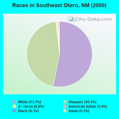
- 4,62153.1%White alone
- 3,92445.1%Hispanic
- 670.8%Two or more races
- 330.4%American Indian alone
- 300.3%Black alone
- 220.3%Asian alone
- 40.05%Native Hawaiian and Other
Pacific Islander alone - 40.05%Other race alone
Races in Southeast Otero detailed stats: ancestries, foreign born residents, place of birth
 Recent articles from our blog. Our writers, many of them Ph.D. graduates or candidates, create easy-to-read articles on a wide variety of topics.

Current Local Time: MST time zone
Land area: 4118.6 square miles.
Population density: 2.2 people per square mile (very low).

| Southeast Otero CCD: | 0.5% ($429) |
| New Mexico: | 0.7% ($699) |
Nearest city with pop. 50,000+: Las Cruces, NM  (69.2 miles , pop. 74,267).
Nearest city with pop. 200,000+: El Paso, TX (71.6 miles , pop. 563,662).
Nearest city with pop. 1,000,000+: Phoenix, AZ (380.3 miles , pop. 1,321,045).
Nearest cities:
), Latitude: 32.57 N, Longitude: 105.62 W
Area code commonly used in this area: 505

| Here: | 3.5% |
| New Mexico: | 3.6% |

- Construction (15.1%)
- Educational services (9.7%)
- Accommodation & food services (9.7%)
- Public administration (6.0%)
- Professional, scientific, technical services (4.7%)
- Agriculture, forestry, fishing & hunting (4.2%)
- Social assistance (3.2%)
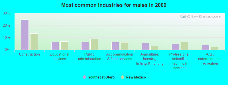
- Construction (24.5%)
- Educational services (6.4%)
- Public administration (6.4%)
- Accommodation & food services (6.2%)
- Agriculture, forestry, fishing & hunting (5.3%)
- Professional, scientific, technical services (4.9%)
- Arts, entertainment, recreation (3.8%)
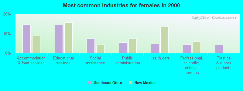
- Accommodation & food services (14.6%)
- Educational services (14.4%)
- Social assistance (7.5%)
- Public administration (5.4%)
- Health care (4.7%)
- Professional, scientific, technical services (4.5%)
- Plastics & rubber products (4.1%)
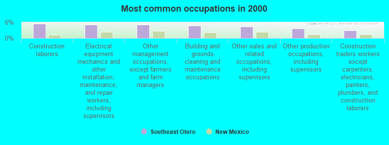
- Construction laborers (5.5%)
- Electrical equipment mechanics and other installation, maintenance, and repair workers, including supervisors (5.1%)
- Other management occupations, except farmers and farm managers (5.1%)
- Building and grounds cleaning and maintenance occupations (4.7%)
- Other sales and related occupations, including supervisors (4.4%)
- Other production occupations, including supervisors (3.6%)
- Construction traders workers except carpenters, electricians, painters, plumbers, and construction laborers (3.0%)
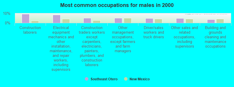
- Construction laborers (9.3%)
- Electrical equipment mechanics and other installation, maintenance, and repair workers, including supervisors (8.5%)
- Construction traders workers except carpenters, electricians, painters, plumbers, and construction laborers (5.1%)
- Other management occupations, except farmers and farm managers (5.1%)
- Driver/sales workers and truck drivers (5.0%)
- Other sales and related occupations, including supervisors (4.7%)
- Building and grounds cleaning and maintenance occupations (3.7%)
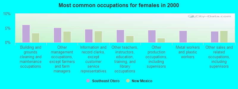
- Building and grounds cleaning and maintenance occupations (6.2%)
- Other management occupations, except farmers and farm managers (5.1%)
- Information and record clerks, except customer service representatives (4.6%)
- Other teachers, instructors, education, training, and library occupations (4.5%)
- Other production occupations, including supervisors (4.4%)
- Metal workers and plastic workers (4.1%)
- Other sales and related occupations, including supervisors (3.9%)
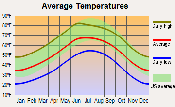
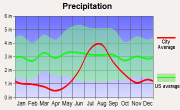
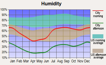
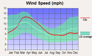
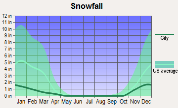
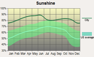
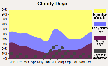
Average climate in Southeast Otero, New Mexico
Based on data reported by over 4,000 weather stations
Earthquake activity:
Southeast Otero-area historical earthquake activity is significantly above New Mexico state average. It is 428% greater than the overall U.S. average.On 4/14/1995 at 00:32:56, a magnitude 5.7 (5.6 MB, 5.7 MS, 5.7 MW, Depth: 11.1 mi, Class: Moderate, Intensity: VI - VII) earthquake occurred 206.6 miles away from Southeast Otero center
On 3/26/2020 at 15:16:27, a magnitude 5.0 (5.0 MW, Depth: 5.9 mi) earthquake occurred 109.4 miles away from the city center
On 6/29/2014 at 04:59:35, a magnitude 5.3 (5.3 MW, Depth: 4.0 mi) earthquake occurred 207.0 miles away from Southeast Otero center
On 1/2/1992 at 11:45:35, a magnitude 5.0 (4.6 MB, 5.0 LG, Depth: 3.1 mi) earthquake occurred 147.7 miles away from Southeast Otero center
On 1/29/1990 at 13:16:10, a magnitude 4.8 (4.5 MB, 4.8 LG, Depth: 7.5 mi, Class: Light, Intensity: IV - V) earthquake occurred 149.9 miles away from Southeast Otero center
On 1/4/2006 at 08:32:32, a magnitude 6.6 (6.6 MW, Depth: 8.7 mi, Class: Strong, Intensity: VII - IX) earthquake occurred 493.1 miles away from the city center
Magnitude types: regional Lg-wave magnitude (LG), body-wave magnitude (MB), surface-wave magnitude (MS), moment magnitude (MW)
Natural disasters:
The number of natural disasters in Otero County (16) is near the US average (15).Major Disasters (Presidential) Declared: 8
Emergencies Declared: 2
Causes of natural disasters: Fires: 7, Floods: 6, Storms: 6, Hurricane: 1, Mudslide: 1, Winter Storm: 1, Other: 1 (Note: some incidents may be assigned to more than one category).
Colleges/universities with over 2000 students nearest to Southeast Otero:
- New Mexico State University-Main Campus (about 69 miles; Las Cruces, NM; Full-time enrollment: 14,497)
- New Mexico State University-Dona Ana (about 70 miles; Las Cruces, NM; FT enrollment: 5,640)
- El Paso Community College (about 71 miles; El Paso, TX; FT enrollment: 19,576)
- Vista College (about 72 miles; El Paso, TX; FT enrollment: 3,453)
- The University of Texas at El Paso (about 76 miles; El Paso, TX; FT enrollment: 18,008)
- Eastern New Mexico University-Roswell Campus (about 82 miles; Roswell, NM; FT enrollment: 2,212)
- Western New Mexico University (about 157 miles; Silver City, NM; FT enrollment: 2,456)
Points of interest:
Notable locations in Southeast Otero: Lewis Ranch (A), Panama Ranch (B), Little Well (C), Pine Springs Camp (D), McArron Ranch (E), Prude Ranch (F), Mesa Horse Camp (G), New Well (H), North Pasture Windmill (I), North Well (J), Rogers Ruins (K), Sacramento City (L), Sacramento Side Camp (M), Saddle Campground (N), Pate Windmill (O), Perry Well (P), Perry Windmill (Q), Pine Campground (R), Silver Campground (S), Sivells Baptist Camp (T). Display/hide their locations on the map
Churches in Southeast Otero include: High Rolls-Mountain Park Methodist Church Historic Site (A), Church of Christ (B), First Baptist Church (C), Cloudcroft Christian Center (D), Weed Baptist Church (E), Christadelphian Church (F), Orogrande Baptist Mission (G), First Baptist Church (H), Trinity Baptist Church (I). Display/hide their locations on the map
Cemeteries: Marcia Cemetery (1), Avis Cemetery (2), Piñon Cemetery (3), Mayhill Cemetery (4), Bass Cemetery (5), Mountain Acres Cemetery (6), Sixteen Springs Cemetery (7). Display/hide their locations on the map
Lakes and reservoirs: Bassett Lake (A), Shockley Lake (B), Dry Lake (C), Cowan Lake (D), Lost Pond (E), Sacramento Lake (F), Tulloch Lake (G), The Lake (H). Display/hide their locations on the map
Streams, rivers, and creeks: Little Stevens Creek (A), South Prong Stevens Creek (B), Sacramento River (C), Piñon Wash (D), Piñon Creek (E), Jernigan Wash (F), Pendejo Wash (G), Bear Creek (H). Display/hide their locations on the map
Parks in Southeast Otero include: Brokeoff Mountains Wilderness Study Area (1), Culp Canyon Wilderness Study Area (2), Cloud Climbing Railroad Historical Marker (3), Zenith Park (4). Display/hide their locations on the map
| This place: | 2.9 people |
| New Mexico: | 2.5 people |
| This place: | 75.7% |
| Whole state: | 65.5% |
| This place: | 5.6% |
| Whole state: | 8.2% |
Likely homosexual households (counted as self-reported same-sex unmarried-partner households)
- Lesbian couples: 0.5% of all households
- Gay men: 0.3% of all households
| This place: | 30.0% |
| Whole state: | 18.4% |
| This place: | 13.7% |
| Whole state: | 7.8% |
People in group quarters in Southeast Otero in 2010:
- 1,077 people in local jails and other municipal confinement facilities
- 18 people in workers' group living quarters and job corps centers
- 5 people in group homes for juveniles (non-correctional)
2 people in religious group quarters in 2000
For population 15 years and over in Southeast Otero:
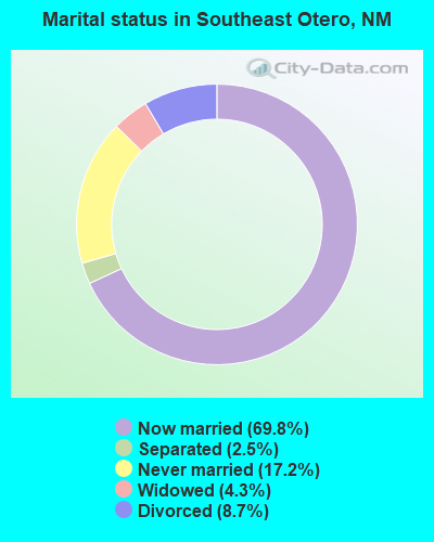
- Never married: 17.2%
- Now married: 69.8%
- Separated: 2.5%
- Widowed: 4.3%
- Divorced: 8.7%
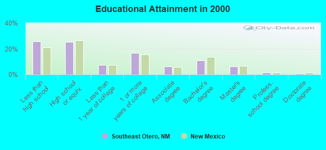
For population 25 years and over in Southeast Otero:
- High school or higher: 74.5%
- Bachelor's degree or higher: 19.2%
- Graduate or professional degree: 8.3%
- Unemployed: 10.4%
- Mean travel time to work (commute): 25.1 minutes
| Here: | 15.1 |
| New Mexico average: | 14.5 |
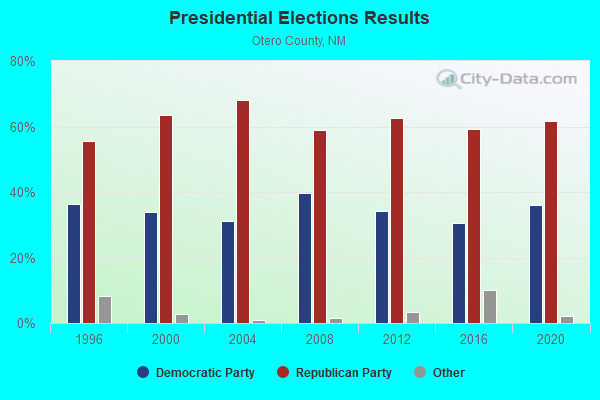


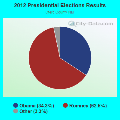
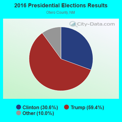
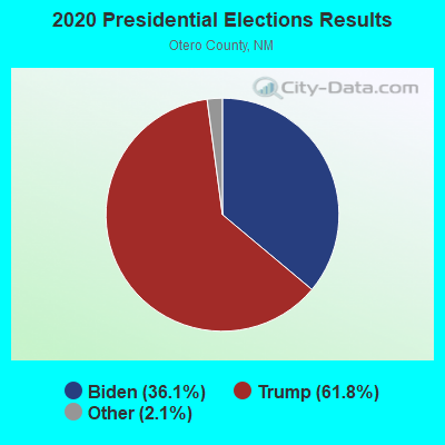
Graphs represent county-level data. Detailed 2008 Election Results
Religion statistics for Southeast Otero, NM (based on Otero County data)
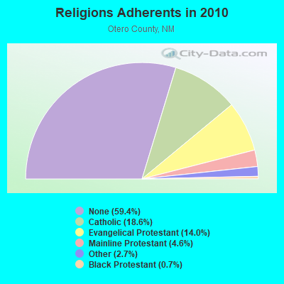
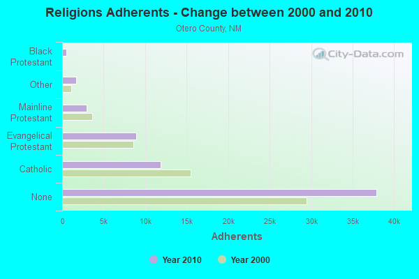
| Religion | Adherents | Congregations |
|---|---|---|
| Catholic | 11,862 | 11 |
| Evangelical Protestant | 8,947 | 55 |
| Mainline Protestant | 2,913 | 12 |
| Other | 1,712 | 11 |
| Black Protestant | 466 | 5 |
| None | 37,897 | - |
Food Environment Statistics:
| Otero County: | 0.96 / 10,000 pop. |
| State: | 1.44 / 10,000 pop. |
| This county: | 0.16 / 10,000 pop. |
| New Mexico: | 0.21 / 10,000 pop. |
| Otero County: | 0.32 / 10,000 pop. |
| New Mexico: | 0.32 / 10,000 pop. |
| This county: | 4.30 / 10,000 pop. |
| State: | 4.06 / 10,000 pop. |
| Otero County: | 5.58 / 10,000 pop. |
| New Mexico: | 7.12 / 10,000 pop. |
| This county: | 6.8% |
| New Mexico: | 6.4% |
| This county: | 25.8% |
| New Mexico: | 22.1% |
10.22% of this county's 2021 resident taxpayers lived in other counties in 2020 ($45,060 average adjusted gross income)
| Here: | 10.22% |
| New Mexico average: | 6.50% |
0.77% of residents moved from foreign countries ($3,859 average AGI)
Otero County: 0.77% New Mexico average: 0.07%
Top counties from which taxpayers relocated into this county between 2020 and 2021:
| from Dona Ana County, NM | |
| from El Paso County, TX | |
| from Bernalillo County, NM |
9.90% of this county's 2020 resident taxpayers moved to other counties in 2021 ($49,426 average adjusted gross income)
| Here: | 9.90% |
| New Mexico average: | 6.53% |
0.54% of residents moved to foreign countries ($2,709 average AGI)
Otero County: 0.54% New Mexico average: 0.05%
Top counties to which taxpayers relocated from this county between 2020 and 2021:
| to Dona Ana County, NM | |
| to El Paso County, TX | |
| to Clark County, NV |
Strongest AM radio stations in Southeast Otero:
- KINF (1020 AM; 50 kW; ROSWELL, NM; Owner: JAMES CRYSTAL HOLDINGS OF NEW MEXICO, INC.)
- KELP (1590 AM; 50 kW; EL PASO, TX; Owner: MCCLATCHEY BROADCASTING)
- KTSM (690 AM; 10 kW; EL PASO, TX; Owner: CCB TEXAS LICENSES, L.P.)
- KAMA (750 AM; 10 kW; EL PASO, TX; Owner: TICHENOR LICENSE CORPORATION ("TLC"))
- KBNA (920 AM; 10 kW; EL PASO, TX; Owner: TICHENOR LICENSE CORPORATION ("TLC"))
- KROD (600 AM; 5 kW; EL PASO, TX; Owner: REGENT LICENSEE OF EL PASO, INC.)
- KXPL (1060 AM; daytime; 10 kW; EL PASO, TX; Owner: K-FINA RESULTS, INC.)
- KSVE (1150 AM; 10 kW; EL PASO, TX; Owner: ENTRAVISION HOLDINGS, LLC)
- KSNM (570 AM; 5 kW; LAS CRUCES, NM; Owner: SUNRISE BROADCASTING INC.)
- KICA (980 AM; 50 kW; CLOVIS, NM; Owner: BROADCAST ENTERTAINMENT CORPORATION)
- KBUY (1360 AM; 5 kW; RUIDOSO, NM; Owner: WALTON STATIONS-NEW MEXICO, INC.)
- KKOB (770 AM; 50 kW; ALBUQUERQUE, NM; Owner: CITADEL BROADCASTING COMPANY)
- KMUL (1380 AM; 50 kW; MULESHOE, TX; Owner: BROADCAST ENTERTAINMENT CORPORATION)
Strongest FM radio stations in Southeast Otero:
- K205DE (88.9 FM; ALAMOGORDO, NM; Owner: PAULINO BERNAL EVANGELISM)
- K256AI (99.1 FM; ALAMOGORDO, NM; Owner: CALVARY CHAPEL OF TWIN FALLS, INC.)
- K215EC (91.1 FM; ALAMOGORDO, NM; Owner: CALVARY CHAPEL OF TWIN FALLS, INC.)
- KZZX (105.3 FM; ALAMOGORDO, NM; Owner: BURT BROADCASTING, INC.)
- K249DD (97.7 FM; RUIDOSO, NM; Owner: ROSWELL CHRISTIAN RADIO, INC.)
- KNMB (96.7 FM; CLOUDCROFT, NM; Owner: MTD, INC.)
- KIDX (101.5 FM; RUIDOSO, NM; Owner: MTD, INC.)
- K240CN (95.9 FM; RUIDOSO, NM; Owner: FRIENDS OF KHFM-RUIDOSO)
- K297AE (107.3 FM; RUIDOSO, NM; Owner: FAMILY LIFE BROADCASTING SYSTEM)
- KNMZ (103.7 FM; ALAMOGORDO, NM; Owner: RUNNELS BROADCASTING SYSTEM, LLC, DEBTOR IN POSSESSION)
- KRSY-FM (92.7 FM; LA LUZ, NM; Owner: RUNNELS BROADCASTING SYSTEM, LLC, DEBTOR IN POSSESSION)
TV broadcast stations around Southeast Otero:
- K12MP (Channel 12; TIMBERON, NM; Owner: VISION BROADCASTING NETWORK, INC.)
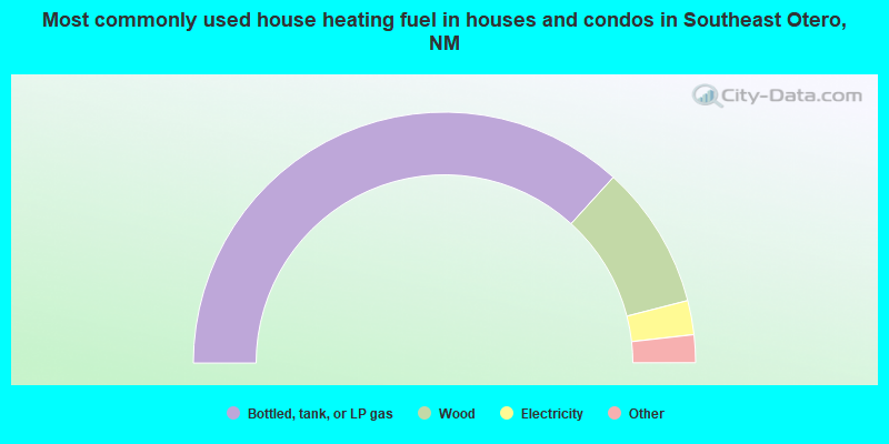
- 73.5%Bottled, tank, or LP gas
- 18.5%Wood
- 4.4%Electricity
- 1.5%Utility gas
- 0.8%Other fuel
- 0.7%Solar energy
- 0.5%No fuel used
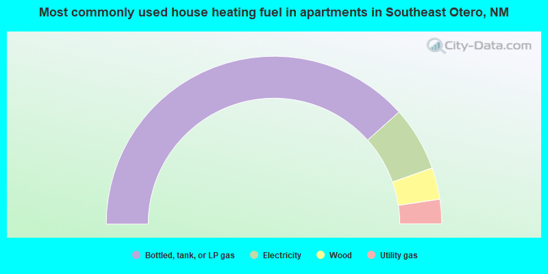
- 76.7%Bottled, tank, or LP gas
- 12.4%Electricity
- 6.1%Wood
- 4.7%Utility gas
Southeast Otero compared to New Mexico state average:
- Black race population percentage below state average.
- Foreign-born population percentage significantly below state average.
- Renting percentage below state average.
- Length of stay since moving in significantly above state average.
- Number of rooms per house significantly below state average.
- House age significantly below state average.
- Institutionalized population percentage significantly above state average.
- Number of college students below state average.
Southeast Otero on our top lists:
- #3 on the list of "Top 101 cities with largest percentage of females in industries: health and personal care, except drug, stores (population 5,000+)"
- #4 on the list of "Top 101 cities with largest percentage of males in occupations: construction laborers (population 5,000+)"
- #4 on the list of "Top 101 cities with largest percentage of females in industries: plastics and rubber products (population 5,000+)"
- #5 on the list of "Top 101 cities with largest percentage of females in occupations: material moving workers except supervisors and laborers and material movers, hand (population 5,000+)"
- #5 on the list of "Top 101 cities with largest percentage of females in occupations: painters and paperhangers (population 5,000+)"
- #8 on the list of "Top 101 cities with largest percentage of females in occupations: metal workers and plastic workers (population 5,000+)"
- #8 on the list of "Top 101 cities with largest percentage of females in industries: machinery, equipment, and supplies merchant wholesalers (population 5,000+)"
- #12 on the list of "Top 101 cities with largest percentage of females in industries: leather and allied products (population 5,000+)"
- #12 on the list of "Top 100 cities with largest land areas"
- #15 on the list of "Top 101 cities with largest percentage of females in industries: electrical equipment, appliances, and components (population 5,000+)"
- #20 on the list of "Top 101 cities with largest percentage of males in industries: personal and laundry services (population 5,000+)"
- #21 on the list of "Top 101 cities with largest percentage of females in occupations: other food preparation and serving workers including supervisors (population 5,000+)"
- #24 on the list of "Top 101 cities with largest percentage of males in occupations: other construction workers and helpers (population 5,000+)"
- #42 on the list of "Top 101 cities with largest percentage of females in industries: social assistance (population 5,000+)"
- #64 on the list of "Top 101 cities with the most people below 50% of the poverty level, excluding cities with 15% or more of residents in college and with the median age below 28 (population 5,000+)"
- #65 on the list of "Top 101 cities with largest percentage of males in industries: electrical equipment, appliances, and components (population 5,000+)"
- #74 on the list of "Top 101 cities with largest percentage of males in industries: wood products (population 5,000+)"
- #97 on the list of "Top 101 cities with largest percentage of females in industries: other direct selling establishments (population 5,000+)"
- #101 on the list of "Top 101 cities with largest percentage of males in industries: furniture and home furnishings, and household appliance stores (population 5,000+)"
- #52 (88350) on the list of "Top 101 zip codes with the largest percentage of Lithuanian first ancestries"
- #9 on the list of "Top 101 counties with the highest percentage of residents relocating from foreign countries between 2010 and 2011"
- #21 on the list of "Top 101 counties with the highest percentage of residents relocating to foreign countries in 2011"
- #52 on the list of "Top 101 counties with the largest increase in the number of deaths per 1000 residents 2000-2006 to 2007-2013 (pop. 50,000+)"
- #60 on the list of "Top 101 counties with highest percentage of residents voting for 3rd party candidates in the 2012 Presidential Election"
- #92 on the list of "Top 101 counties with the largest number of people moving in compared to moving out (pop. 50,000+)"