South of the Yellowstone, Montana
Submit your own pictures of this place and show them to the world
- OSM Map
- General Map
- Google Map
- MSN Map

| Males: 1,414 | |
| Females: 1,458 |
| Median resident age: | 40.7 years |
| Montana median age: | 37.5 years |
Zip code: 59052
| South of the Yellowstone: | $66,076 |
| MT: | $67,631 |
Estimated per capita income in 2022: $36,184 (it was $17,993 in 2000)
South of the Yellowstone CCD income, earnings, and wages data
Estimated median house or condo value in 2022: $297,225 (it was $98,700 in 2000)
| South of the Yellowstone: | $297,225 |
| MT: | $366,400 |
Mean prices in 2022: all housing units: $758,206; detached houses: $824,777; townhouses or other attached units: $243,990; mobile homes: $233,546
South of the Yellowstone, MT residents, houses, and apartments details
Detailed information about poverty and poor residents in South of the Yellowstone, MT
Compare current foreclosures near South of the Yellowstone, MT:
| Photo | Address | Area | Beds / Baths | Price | Details |
|---|---|---|---|---|---|

|
#1
Howie Rd
Big Timber, MT 59011
|
1,108 sq. feet
|
1 baths 2 beds |
show details | |

|
Check over 1 million property listings on Foreclosure.com!
|
browse all offers | |||

- 2,69095.9%White alone
- 441.6%Hispanic
- 341.2%Two or more races
- 190.7%American Indian alone
- 100.4%Asian alone
- 80.3%Other race alone
- 10.04%Native Hawaiian and Other
Pacific Islander alone

Races in South of the Yellowstone detailed stats: ancestries, foreign born residents, place of birth
 Recent articles from our blog. Our writers, many of them Ph.D. graduates or candidates, create easy-to-read articles on a wide variety of topics.
Current Local Time: MST time zone
Land area: 772.4 square miles.
Population density: 3.7 people per square mile (very low).

| South of the Yellowstone CCD: | 0.8% ($771) |
| Montana: | 1.3% ($1,212) |
Nearest city with pop. 50,000+: Billings, MT  (67.4 miles , pop. 89,847).
Nearest city with pop. 200,000+: West Adams, CO (475.0 miles , pop. 259,628).
Nearest city with pop. 1,000,000+: Phoenix, AZ (850.3 miles , pop. 1,321,045).
Nearest cities:
), Latitude: 45.71 N, Longitude: 109.93 W
Area code commonly used in this area: 406


| Here: | 3.1% |
| Montana: | 3.8% |

- Agriculture, forestry, fishing & hunting (13.6%)
- Construction (13.0%)
- Accommodation & food services (10.2%)
- Educational services (8.5%)
- Health care (7.7%)
- Food & beverage stores (4.7%)
- Public administration (4.7%)

- Construction (21.9%)
- Agriculture, forestry, fishing & hunting (18.5%)
- Mining, quarrying, oil & gas extraction (7.9%)
- Accommodation & food services (5.8%)
- Educational services (4.7%)
- Metal & metal products (4.4%)
- Public administration (3.2%)

- Accommodation & food services (15.6%)
- Health care (15.1%)
- Educational services (13.2%)
- Agriculture, forestry, fishing & hunting (7.7%)
- Food & beverage stores (7.5%)
- Public administration (6.5%)
- Professional, scientific, technical services (5.5%)

- Farmers and farm managers (7.4%)
- Other management occupations, except farmers and farm managers (5.3%)
- Building and grounds cleaning and maintenance occupations (5.1%)
- Agricultural workers, including supervisors (4.0%)
- Carpenters (3.9%)
- Cashiers (3.5%)
- Cooks and food preparation workers (3.1%)

- Farmers and farm managers (11.0%)
- Carpenters (7.1%)
- Other management occupations, except farmers and farm managers (6.3%)
- Agricultural workers, including supervisors (5.2%)
- Metal workers and plastic workers (4.7%)
- Vehicle and mobile equipment mechanics, installers, and repairers (4.2%)
- Construction traders workers except carpenters, electricians, painters, plumbers, and construction laborers (3.8%)

- Building and grounds cleaning and maintenance occupations (6.7%)
- Secretaries and administrative assistants (6.4%)
- Nursing, psychiatric, and home health aides (6.0%)
- Preschool, kindergarten, elementary, and middle school teachers (5.2%)
- Cashiers (4.8%)
- Cooks and food preparation workers (4.7%)
- Waiters and waitresses (4.7%)
Average climate in South of the Yellowstone, Montana
Based on data reported by over 4,000 weather stations


Earthquake activity:
South of the Yellowstone-area historical earthquake activity is significantly above Montana state average. It is 856% greater than the overall U.S. average.On 8/18/1959 at 06:37:13, a magnitude 7.7 (7.7 UK, Class: Major, Intensity: VIII - XII) earthquake occurred 86.8 miles away from South of the Yellowstone center, causing $26,000,000 total damage
On 10/28/1983 at 14:06:06, a magnitude 7.3 (6.2 MB, 7.3 MS, 7.0 MW) earthquake occurred 220.8 miles away from the city center, causing 2 deaths (2 shaking deaths) and 3 injuries, causing $15,000,000 total damage
On 6/30/1975 at 18:54:13, a magnitude 6.1 (5.6 MB, 5.9 MS, 6.1 UK, 6.1 ML, Class: Strong, Intensity: VII - IX) earthquake occurred 81.9 miles away from South of the Yellowstone center
On 3/31/2020 at 23:52:30, a magnitude 6.5 (6.5 MW, Depth: 7.5 mi) earthquake occurred 267.5 miles away from South of the Yellowstone center
On 7/6/2017 at 06:30:17, a magnitude 5.8 (5.8 MW, Depth: 7.6 mi, Class: Moderate, Intensity: VI - VII) earthquake occurred 150.1 miles away from South of the Yellowstone center
On 7/26/2005 at 04:08:37, a magnitude 5.7 (5.7 MB, 5.2 MS, 5.6 MW) earthquake occurred 129.9 miles away from the city center
Magnitude types: body-wave magnitude (MB), local magnitude (ML), surface-wave magnitude (MS), moment magnitude (MW)
Natural disasters:
The number of natural disasters in Sweet Grass County (7) is smaller than the US average (15).Major Disasters (Presidential) Declared: 3
Emergencies Declared: 1
Causes of natural disasters: Fires: 3, Floods: 2, Storms: 2, Hurricane: 1, Snow: 1, Other: 1 (Note: some incidents may be assigned to more than one category).
Colleges/universities with over 2000 students nearest to South of the Yellowstone:
- Montana State University (about 55 miles; Bozeman, MT; Full-time enrollment: 12,942)
- Montana State University-Billings (about 69 miles; Billings, MT; FT enrollment: 4,319)
- Sheridan College (about 160 miles; Sheridan, WY; FT enrollment: 2,070)
- Brigham Young University-Idaho (about 160 miles; Rexburg, ID; FT enrollment: 30,522)
- The University of Montana (about 210 miles; Missoula, MT; FT enrollment: 13,602)
- Idaho State University (about 233 miles; Pocatello, ID; FT enrollment: 10,350)
- Casper College (about 268 miles; Casper, WY; FT enrollment: 2,770)
Points of interest:
Notable locations in South of the Yellowstone: Camp-on-the-Boulder (A), Camp Mimanagish (B), Mason Homestead (C), Bert Woods Homestead (D), Aspen Campground (E), Blanchard Homestead (F), Bob Woods Homestead (G), Boe Ranch (H), Falls Creek Campground (I), Chippy Park Campground (J), McConnell Homestead (K), McKinsey Homestead (L), Carney Ranch (M), Clayton Ranch (N), Currier Ranch (O), Eatons Inn (P), Foster Ranch (Q), Seaforth Homestead (R), Seasongood Homestead (S), Hash Homestead (T). Display/hide their locations on the map
Churches in South of the Yellowstone include: Big Timber Church of God (A), Big Timber Lutheran Church (B), Church of Christ (C), Saint Josephs Catholic Church (D), Evangelical Church of North America (E), Big Timber Evangelical Free Church (F), Congregational Church (G), Seventh Day Adventist Church (H), Saint Marks Episcopal Church (I). Display/hide their locations on the map
Cemeteries: Kent Cemetery (1), Mountain View Cemetery (2), Reed Point Cemetery (3), Thomas Massacre Graves Historical (4), Reed Point Cemetery (5). Display/hide their locations on the map
Lakes and swamps: Kent Lake (A), Camp Lake (B), Horseshoe Lake (C), Burnt Gulch Lake (D), Wounded Man Lake (E), Emerald Lake (F), Rainbow Lakes (G), Favonius Lake (H). Display/hide their locations on the map
Rivers and creeks: Work Creek (A), Milligan Creek (B), Antelope Creek (C), Bear Pen Creek (D), Blacktail Creek (E), Blakely Creek (F), East Chippy Creek (G), Bohee Creek (H), Boulder River (I). Display/hide their locations on the map
Parks in South of the Yellowstone include: Natural Bridge State Park (1), Greycliff Prairie Dog Town State Park (2), Thomas Party Historical Marker (3), Captain William Clark Historical Marker (4), Crazy Mountains Historical Marker (5), Bonanza or Bozeman Trail Historical Marker (6), Lions Club Park (7). Display/hide their locations on the map
| This place: | 2.2 people |
| Montana: | 2.4 people |
| This place: | 62.8% |
| Whole state: | 62.8% |
| This place: | 4.5% |
| Whole state: | 6.7% |
Likely homosexual households (counted as self-reported same-sex unmarried-partner households)
- Lesbian couples: 0.1% of all households
- Gay men: 0.2% of all households
| This place: | 10.9% |
| Whole state: | 14.6% |
| This place: | 2.0% |
| Whole state: | 5.8% |
52 people in nursing homes in 2000
5 people in other workers' dormitories in 2000
For population 15 years and over in South of the Yellowstone:

- Never married: 17.8%
- Now married: 64.7%
- Separated: 0.8%
- Widowed: 9.0%
- Divorced: 8.5%
For population 25 years and over in South of the Yellowstone:
- High school or higher: 88.8%
- Bachelor's degree or higher: 23.7%
- Graduate or professional degree: 4.7%
- Unemployed: 2.4%
- Mean travel time to work (commute): 18.4 minutes


| Here: | 9.6 |
| Montana average: | 10.4 |
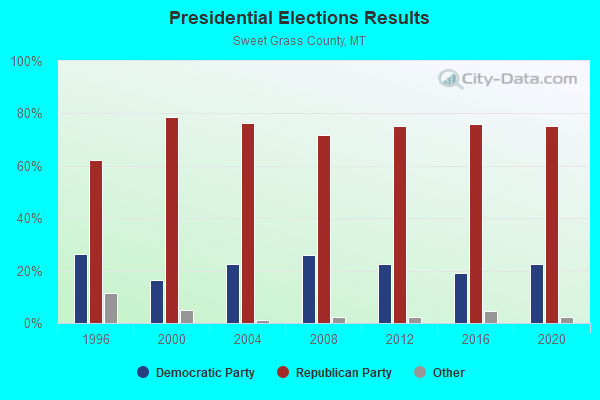
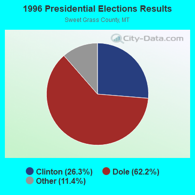

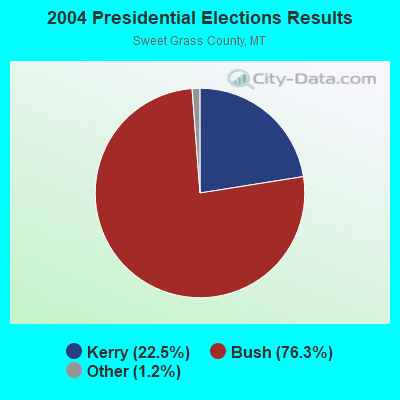
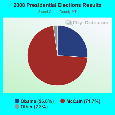

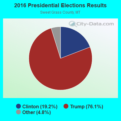
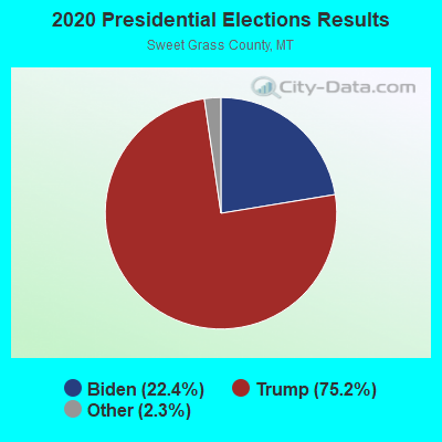
Graphs represent county-level data. Detailed 2008 Election Results
Religion statistics for South of the Yellowstone, MT (based on Sweet Grass County data)
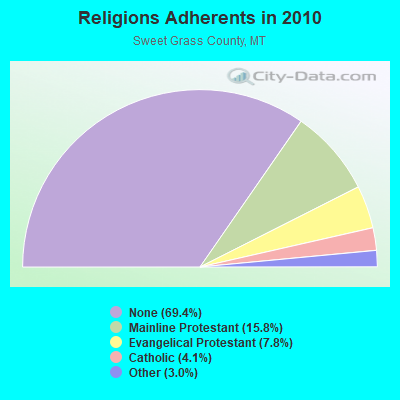
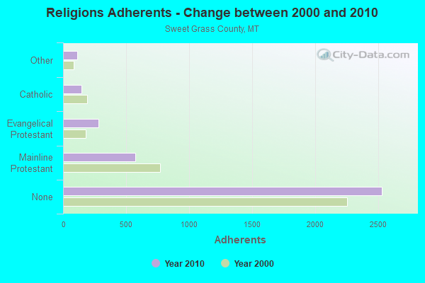
| Religion | Adherents | Congregations |
|---|---|---|
| Mainline Protestant | 576 | 3 |
| Evangelical Protestant | 283 | 6 |
| Catholic | 148 | 1 |
| Other | 111 | 1 |
| None | 2,533 | - |
Food Environment Statistics:
| This county: | 2.64 / 10,000 pop. |
| State: | 2.55 / 10,000 pop. |
| Here: | 7.91 / 10,000 pop. |
| Montana: | 4.69 / 10,000 pop. |
| Sweet Grass County: | 7.91 / 10,000 pop. |
| Montana: | 10.38 / 10,000 pop. |
| This county: | 7.3% |
| Montana: | 7.2% |
| Here: | 20.0% |
| Montana: | 23.1% |
Strongest AM radio stations in South of the Yellowstone:
- KGVW (640 AM; 10 kW; BELGRADE, MT; Owner: GALLATIN VALLEY WITNESS, INC.)
- KGHL (790 AM; 5 kW; BILLINGS, MT; Owner: NEW NORTHWEST BROADCASTERS, LLC)
- KBOZ (1090 AM; 5 kW; BOZEMAN, MT; Owner: REIER BROADCASTING COMPANY, INC.)
- KURL (730 AM; 5 kW; BILLINGS, MT; Owner: ELENBAAS MEDIA, INC.)
- KBUL (970 AM; 5 kW; BILLINGS, MT; Owner: CAPSTAR TX LIMITED PARTNERSHIP)
- KERR (750 AM; 50 kW; POLSON, MT; Owner: ANDERSON RADIO BROADCASTING, INC.)
- KPRK (1340 AM; 1 kW; LIVINGSTON, MT; Owner: CAPSTAR TX LIMITED PARTNERSHIP)
- KTWO (1030 AM; 50 kW; CASPER, WY; Owner: CITICASTERS LICENSES, L.P.)
- KOFI (1180 AM; 50 kW; KALISPELL, MT; Owner: KOFI, INC.)
- KBOI (670 AM; 50 kW; BOISE, ID; Owner: CITADEL BROADCASTING COMPANY)
- KKGR (680 AM; daytime; 5 kW; EAST HELENA, MT; Owner: KKGR, INC.)
- KALL (700 AM; 50 kW; NORTH SALT LAKE CITY, UT; Owner: CITICASTERS LICENSES, L.P.)
- KZMQ (1140 AM; daytime; 10 kW; GREYBULL, WY; Owner: LEGEND COMMUNICATIONS OF WYOMING LLC)
Strongest FM radio stations in South of the Yellowstone:
- KMXE (99.3 FM; RED LODGE, MT; Owner: SILVER ROCK COMMUNICATIONS INC.)
- K240CO (95.9 FM; LIVINGSTON, MT; Owner: REIER BROADCASTING COMPANY, INC.)
- KXLB (100.7 FM; LIVINGSTON, MT; Owner: CAPSTAR TX LIMITED PARTNERSHIP)

- 67.2%Utility gas
- 13.1%Wood
- 10.0%Bottled, tank, or LP gas
- 6.6%Electricity
- 1.6%Other fuel
- 1.4%Fuel oil, kerosene, etc.

- 58.2%Utility gas
- 22.1%Electricity
- 9.5%Bottled, tank, or LP gas
- 9.5%Wood
- 0.7%Fuel oil, kerosene, etc.
South of the Yellowstone compared to Montana state average:
- Unemployed percentage significantly below state average.
- Black race population percentage significantly below state average.
- Hispanic race population percentage below state average.
- Foreign-born population percentage significantly below state average.
- Length of stay since moving in significantly above state average.
- Number of rooms per house significantly below state average.
- House age significantly below state average.
- Number of college students below state average.