South Treasure, Montana
Submit your own pictures of this place and show them to the world
- OSM Map
- General Map
- Google Map
- MSN Map

| Males: 217 | |
| Females: 218 |
| Median resident age: | 43.9 years |
| Montana median age: | 37.5 years |
Zip code: 59010
| South Treasure: | $75,110 |
| MT: | $67,631 |
Estimated per capita income in 2022: $44,643 (it was $16,982 in 2000)
South Treasure CCD income, earnings, and wages data
Estimated median house or condo value in 2022: $236,996 (it was $42,700 in 2000)
| South Treasure: | $236,996 |
| MT: | $366,400 |
Mean prices in 2022: all housing units: $302,006; detached houses: $323,179; mobile homes: $133,440
South Treasure, MT residents, houses, and apartments details
Detailed information about poverty and poor residents in South Treasure, MT


- 54094.9%White alone
- 142.5%American Indian alone
- 61.1%Hispanic
- 50.9%Two or more races
- 20.4%Asian alone
- 20.4%Other race alone

Races in South Treasure detailed stats: ancestries, foreign born residents, place of birth
 Recent articles from our blog. Our writers, many of them Ph.D. graduates or candidates, create easy-to-read articles on a wide variety of topics.
Current Local Time: MST time zone
Land area: 504.6 square miles.
Population density: 0.9 people per square mile (very low).

| South Treasure CCD: | 1.1% ($476) |
| Montana: | 1.3% ($1,212) |
Nearest city with pop. 50,000+: Billings, MT  (69.4 miles , pop. 89,847).
Nearest city with pop. 200,000+: West Adams, CO (449.8 miles , pop. 259,628).
Nearest city with pop. 1,000,000+: Phoenix, AZ (911.7 miles , pop. 1,321,045).
Nearest cities:
), ), Latitude: 46.17 N, Longitude: 107.21 W
Area code commonly used in this area: 406


| Here: | 2.9% |
| Montana: | 3.8% |

- Agriculture, forestry, fishing & hunting (26.6%)
- Educational services (14.4%)
- Public administration (11.5%)
- Mining, quarrying, oil & gas extraction (4.7%)
- Accommodation & food services (4.3%)
- Repair & maintenance (4.3%)
- Utilities (3.2%)

- Agriculture, forestry, fishing & hunting (37.8%)
- Public administration (9.6%)
- Educational services (8.3%)
- Repair & maintenance (7.7%)
- Mining, quarrying, oil & gas extraction (7.1%)
- Construction (4.5%)
- Other transportation, support activities, couriers (3.2%)

- Educational services (22.1%)
- Public administration (13.9%)
- Agriculture, forestry, fishing & hunting (12.3%)
- Accommodation & food services (7.4%)
- Professional, scientific, technical services (6.6%)
- Health care (5.7%)
- Arts, entertainment, recreation (4.9%)

- Farmers and farm managers (14.7%)
- Agricultural workers, including supervisors (11.9%)
- Other management occupations, except farmers and farm managers (6.1%)
- Preschool, kindergarten, elementary, and middle school teachers (4.3%)
- Vehicle and mobile equipment mechanics, installers, and repairers (4.0%)
- Law enforcement workers, including supervisors (3.2%)
- Building and grounds cleaning and maintenance occupations (3.2%)

- Farmers and farm managers (23.1%)
- Agricultural workers, including supervisors (14.7%)
- Vehicle and mobile equipment mechanics, installers, and repairers (7.1%)
- Other management occupations, except farmers and farm managers (6.4%)
- Law enforcement workers, including supervisors (5.8%)
- Electrical equipment mechanics and other installation, maintenance, and repair workers, including supervisors (5.1%)
- Building and grounds cleaning and maintenance occupations (4.5%)

- Preschool, kindergarten, elementary, and middle school teachers (8.2%)
- Agricultural workers, including supervisors (8.2%)
- Secretaries and administrative assistants (6.6%)
- Other management occupations, except farmers and farm managers (5.7%)
- Material recording, scheduling, dispatching, and distributing workers (4.9%)
- Nursing, psychiatric, and home health aides (4.9%)
- Bookkeeping, accounting, and auditing clerks (4.1%)
Average climate in South Treasure, Montana
Based on data reported by over 4,000 weather stations


Earthquake activity:
South Treasure-area historical earthquake activity is significantly above Montana state average. It is 469% greater than the overall U.S. average.On 8/18/1959 at 06:37:13, a magnitude 7.7 (7.7 UK, Class: Major, Intensity: VIII - XII) earthquake occurred 201.2 miles away from South Treasure center, causing $26,000,000 total damage
On 10/28/1983 at 14:06:06, a magnitude 7.3 (6.2 MB, 7.3 MS, 7.0 MW) earthquake occurred 353.0 miles away from South Treasure center, causing 2 deaths (2 shaking deaths) and 3 injuries, causing $15,000,000 total damage
On 6/30/1975 at 18:54:13, a magnitude 6.1 (5.6 MB, 5.9 MS, 6.1 UK, 6.1 ML, Class: Strong, Intensity: VII - IX) earthquake occurred 200.4 miles away from South Treasure center
On 7/6/2017 at 06:30:17, a magnitude 5.8 (5.8 MW, Depth: 7.6 mi, Class: Moderate, Intensity: VI - VII) earthquake occurred 260.1 miles away from the city center
On 3/31/2020 at 23:52:30, a magnitude 6.5 (6.5 MW, Depth: 7.5 mi) earthquake occurred 402.4 miles away from South Treasure center
On 7/26/2005 at 04:08:37, a magnitude 5.7 (5.7 MB, 5.2 MS, 5.6 MW) earthquake occurred 264.4 miles away from South Treasure center
Magnitude types: body-wave magnitude (MB), local magnitude (ML), surface-wave magnitude (MS), moment magnitude (MW)
Natural disasters:
The number of natural disasters in Treasure County (8) is smaller than the US average (15).Major Disasters (Presidential) Declared: 4
Emergencies Declared: 1
Causes of natural disasters: Floods: 5, Storms: 3, Fire: 1, Hurricane: 1, Snow: 1, Other: 1 (Note: some incidents may be assigned to more than one category).
Colleges/universities with over 2000 students nearest to South Treasure:
- Montana State University-Billings (about 69 miles; Billings, MT; Full-time enrollment: 4,319)
- Sheridan College (about 99 miles; Sheridan, WY; FT enrollment: 2,070)
- Montana State University (about 189 miles; Bozeman, MT; FT enrollment: 12,942)
- Black Hills State University (about 200 miles; Spearfish, SD; FT enrollment: 3,166)
- Casper College (about 236 miles; Casper, WY; FT enrollment: 2,770)
- South Dakota School of Mines and Technology (about 244 miles; Rapid City, SD; FT enrollment: 2,102)
- Brigham Young University-Idaho (about 278 miles; Rexburg, ID; FT enrollment: 30,522)
Points of interest:
Notable locations in South Treasure: Anderson Ranch (A), Barnes Ranch (B), Criswell Ranch (C), Hysham Rest Area (D), Hysham Community Elevator (E), Bob (F), Mike (G), Walt (H), Garverich Ranch (I), Wilson Ranch (J), Hays Ranch (K), Hope Ranch (L), Petersen Ranch (M), Treasure County 89ers Museum (N), Treasure County Courthouse (O), Treasure County Sheriff's Office (P), Hysham Volunteer Fire Department (Q), Treasure County Ambulance (R). Display/hide their locations on the map
Churches in South Treasure include: Saint Josephs Catholic Church (A), Trinity Lutheran Church (B), Hysham Baptist Church (C), Community Presbyterian Church (D). Display/hide their locations on the map
Reservoir: Haines Reservoir (A). Display/hide its location on the map
Creeks: Little Joe Creek (A), Bear Creek (B), Beaver Creek (C), Big Lightning Creek (D), Corral Creek (E), Crystal Creek (F), East Burnt Creek (G), Hutchinson Creek (H), Little Lightning Creek (I). Display/hide their locations on the map
Parks in South Treasure include: Buffalo and Indians Historical Marker (1), The Yellowstone by Wallace McRae Historical Marker (2). Display/hide their locations on the map
| This place: | 2.1 people |
| Montana: | 2.4 people |
| This place: | 64.1% |
| Whole state: | 62.8% |
| This place: | 1.7% |
| Whole state: | 6.7% |
Likely homosexual households (counted as self-reported same-sex unmarried-partner households)
- Lesbian couples: 0.0% of all households
- Gay men: 0.4% of all households
| This place: | 12.1% |
| Whole state: | 14.6% |
| This place: | 5.4% |
| Whole state: | 5.8% |
For population 15 years and over in South Treasure:

- Never married: 17.8%
- Now married: 62.6%
- Separated: 0.9%
- Widowed: 10.6%
- Divorced: 9.0%
For population 25 years and over in South Treasure:
- High school or higher: 85.4%
- Bachelor's degree or higher: 16.2%
- Graduate or professional degree: 2.6%
- Unemployed: 5.8%
- Mean travel time to work (commute): 17.8 minutes


| Here: | 8.5 |
| Montana average: | 10.4 |
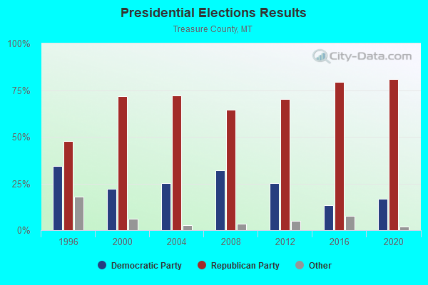
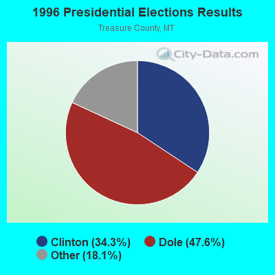
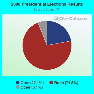
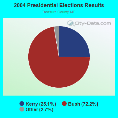
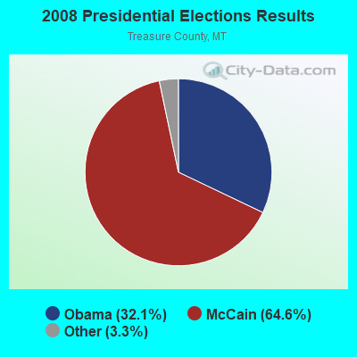
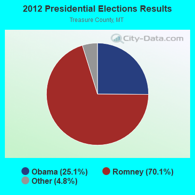
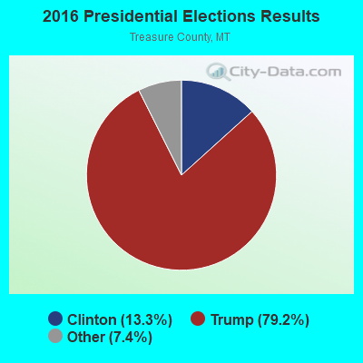
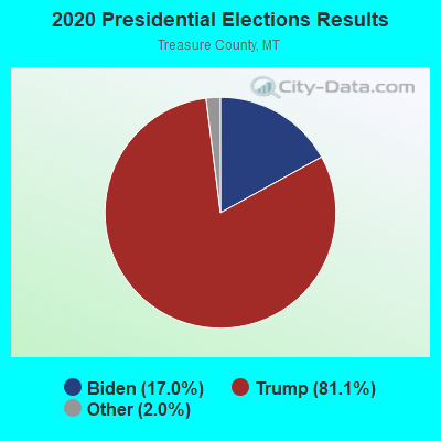
Graphs represent county-level data. Detailed 2008 Election Results
Religion statistics for South Treasure, MT (based on Treasure County data)
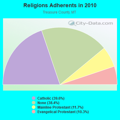
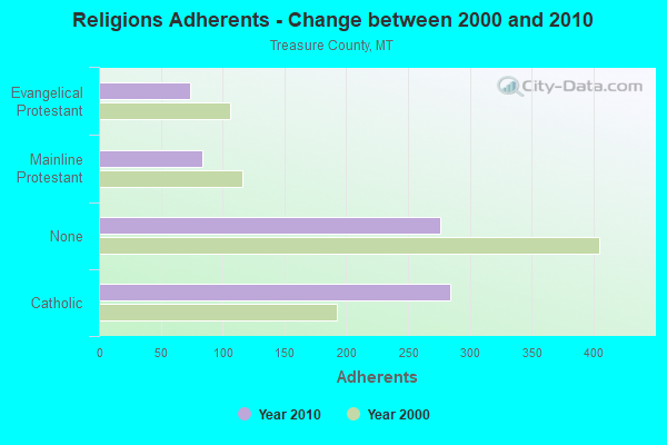
| Religion | Adherents | Congregations |
|---|---|---|
| Catholic | 284 | 1 |
| Mainline Protestant | 84 | 1 |
| Evangelical Protestant | 74 | 2 |
| None | 276 | - |
Food Environment Statistics:
| Here: | 15.43 / 10,000 pop. |
| State: | 2.55 / 10,000 pop. |
| This county: | 15.43 / 10,000 pop. |
| State: | 4.69 / 10,000 pop. |
| Here: | 15.43 / 10,000 pop. |
| Montana: | 10.38 / 10,000 pop. |
| Treasure County: | 7.7% |
| Montana: | 7.2% |
| Treasure County: | 23.5% |
| State: | 23.1% |
Strongest AM radio stations in South Treasure:
- KIKC (1250 AM; 5 kW; FORSYTH, MT; Owner: MILES CITY, FORSYTH B/DCSTG, INC.)
- KATL (770 AM; 10 kW; MILES CITY, MT; Owner: STAR PRINTING COMPANY)
- KMTA (1050 AM; 10 kW; MILES CITY, MT; Owner: SENGER BROADCASTING CORPORATION)
- KURL (730 AM; 5 kW; BILLINGS, MT; Owner: ELENBAAS MEDIA, INC.)
- KGHL (790 AM; 5 kW; BILLINGS, MT; Owner: NEW NORTHWEST BROADCASTERS, LLC)
- KBUL (970 AM; 5 kW; BILLINGS, MT; Owner: CAPSTAR TX LIMITED PARTNERSHIP)
- KTWO (1030 AM; 50 kW; CASPER, WY; Owner: CITICASTERS LICENSES, L.P.)
- KXMR (710 AM; 50 kW; BISMARCK, ND; Owner: RADIO BISMARCK MANDAN, LLC)
- KBHB (810 AM; 25 kW; STURGIS, SD; Owner: MONTEREY LICENSES, LLC)
- KHDN (1230 AM; 1 kW; HARDIN, MT; Owner: SUN MOUNTAIN, INC.)
- KROE (930 AM; 5 kW; SHERIDAN, WY; Owner: LOVCOM, INC.)
- KZMQ (1140 AM; daytime; 10 kW; GREYBULL, WY; Owner: LEGEND COMMUNICATIONS OF WYOMING LLC)
- KERR (750 AM; 50 kW; POLSON, MT; Owner: ANDERSON RADIO BROADCASTING, INC.)
Strongest FM radio stations in South Treasure:
- KMHK (95.5 FM; HARDIN, MT; Owner: CAPSTAR TX LIMITED PARTNERSHIP)
- KIKC-FM (101.3 FM; FORSYTH, MT; Owner: MILES CITY, FORSYTH B/CSTG, INC.)
- KMCJ (99.5 FM; COLSTRIP, MT; Owner: HI-LINE RADIO FELLOWSHIP, INC.)
TV broadcast stations around South Treasure:
- K11OS (Channel 11; HYSHAM, MT; Owner: TREASURE COUNTY T.V. DISTRICT)
- K13PO (Channel 13; HYSHAM, MT; Owner: TREASURE COUNTY T.V. DISTRICT)

- 46.9%Bottled, tank, or LP gas
- 35.4%Electricity
- 7.3%Wood
- 4.7%Coal or coke
- 4.2%Fuel oil, kerosene, etc.
- 1.6%Other fuel

- 48.1%Electricity
- 38.5%Bottled, tank, or LP gas
- 5.8%Wood
- 3.8%Fuel oil, kerosene, etc.
- 3.8%Coal or coke
South Treasure compared to Montana state average:
- Median house value below state average.
- Unemployed percentage below state average.
- Black race population percentage significantly below state average.
- Hispanic race population percentage significantly below state average.
- Median age above state average.
- Foreign-born population percentage significantly below state average.
- Length of stay since moving in significantly above state average.
- Number of rooms per house significantly below state average.
- House age significantly below state average.
- Number of college students below state average.