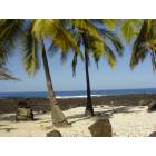
South Kona, Hawaii
Submit your own pictures of this place and show them to the world
- OSM Map
- General Map
- Google Map
- MSN Map

| Males: 5,026 | |
| Females: 4,951 |
| Median resident age: | 41.2 years |
| Hawaii median age: | 36.2 years |
Zip code: 96704
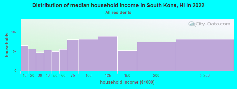
| South Kona: | $76,675 |
| HI: | $92,458 |
Estimated per capita income in 2022: $40,464 (it was $20,177 in 2000)
South Kona CCD income, earnings, and wages data
Estimated median house or condo value in 2022: $742,740 (it was $215,500 in 2000)
| South Kona: | $742,740 |
| HI: | $820,100 |
Mean prices in 2022: all housing units: $595,903; detached houses: $598,158; townhouses or other attached units: $648,474; in 2-unit structures: over $1,000,000; in 3-to-4-unit structures: $549,649; in 5-or-more-unit structures: $517,976; mobile homes: $220,909; occupied boats, rvs, vans, etc.: $401,772
Detailed information about poverty and poor residents in South Kona, HI
Compare current foreclosures near South Kona, HI:
| Photo | Address | Area | Beds / Baths | Price | Details |
|---|---|---|---|---|---|

|
#1
Hukilau Drive
Ocean View, HI 96737
|
1,224 sq. feet
|
2 baths 3 beds |
show details | |

|
#2
Kaohe Rd
Captain Cook, HI 96704
|
- sq. feet
|
- baths - beds |
show details | |

|
#3
Kaohe Rd
Captain Cook, HI 96704
|
- sq. feet
|
- baths - beds |
show details | |

|
#4
Lilikalani Road
Kealakekua, HI 96750
|
- sq. feet
|
- baths - beds |
show details | |

|
#5
Kuakini Hwy
Kailua Kona, HI 96740
|
- sq. feet
|
- baths - beds |
show details | |

|
Check over 1 million property listings on Foreclosure.com!
|
browse all offers | |||

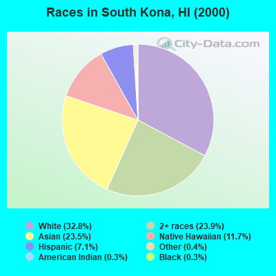
- 2,81532.8%White alone
- 2,05623.9%Two or more races
- 2,01523.5%Asian alone
- 1,00211.7%Native Hawaiian and Other
Pacific Islander alone - 6097.1%Hispanic
- 350.4%Other race alone
- 270.3%Black alone
- 300.3%American Indian alone
Races in South Kona detailed stats: ancestries, foreign born residents, place of birth
 Recent articles from our blog. Our writers, many of them Ph.D. graduates or candidates, create easy-to-read articles on a wide variety of topics.

Current Local Time: HST (no DST) time zone
Land area: 335.4 square miles.
Population density: 30 people per square mile (very low).

| South Kona CCD: | 0.3% ($625) |
| Hawaii: | 0.3% ($765) |
Nearest city with pop. 50,000+: Honolulu, HI  (186.1 miles , pop. 371,657).
Nearest city with pop. 1,000,000+: Los Angeles, CA (2513.6 miles , pop. 3,694,820).
Nearest cities:
), ), ), Latitude: 19.33 N, Longitude: 155.88 W

South Kona tourist attractions:
| Here: | 2.6% |
| Hawaii: | 2.9% |
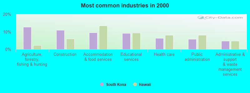
- Agriculture, forestry, fishing & hunting (12.7%)
- Construction (11.0%)
- Accommodation & food services (9.6%)
- Educational services (9.2%)
- Health care (6.4%)
- Public administration (5.8%)
- Administrative & support & waste management services (4.7%)
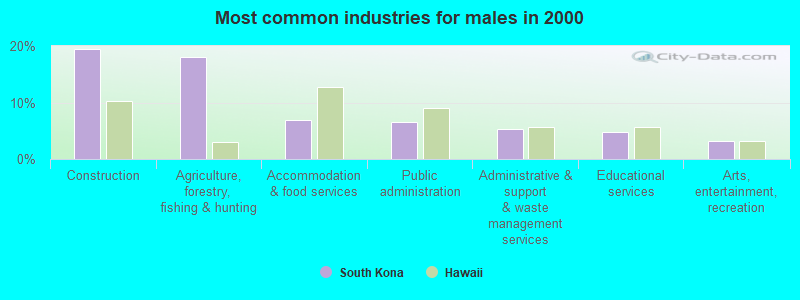
- Construction (19.4%)
- Agriculture, forestry, fishing & hunting (18.1%)
- Accommodation & food services (6.9%)
- Public administration (6.5%)
- Administrative & support & waste management services (5.2%)
- Educational services (4.8%)
- Arts, entertainment, recreation (3.2%)
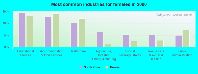
- Educational services (14.3%)
- Accommodation & food services (12.8%)
- Health care (10.3%)
- Agriculture, forestry, fishing & hunting (6.4%)
- Food & beverage stores (5.2%)
- Real estate & rental & leasing (5.1%)
- Public administration (4.9%)
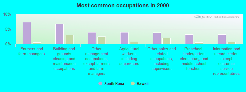
- Farmers and farm managers (7.3%)
- Building and grounds cleaning and maintenance occupations (6.8%)
- Other management occupations, except farmers and farm managers (4.0%)
- Agricultural workers, including supervisors (3.9%)
- Other sales and related occupations, including supervisors (3.8%)
- Preschool, kindergarten, elementary, and middle school teachers (3.2%)
- Information and record clerks, except customer service representatives (3.2%)
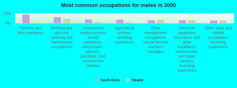
- Farmers and farm managers (11.3%)
- Building and grounds cleaning and maintenance occupations (8.0%)
- Construction traders workers except carpenters, electricians, painters, plumbers, and construction laborers (4.9%)
- Agricultural workers, including supervisors (4.8%)
- Other management occupations, except farmers and farm managers (4.0%)
- Electrical equipment mechanics and other installation, maintenance, and repair workers, including supervisors (4.0%)
- Other sales and related occupations, including supervisors (3.6%)
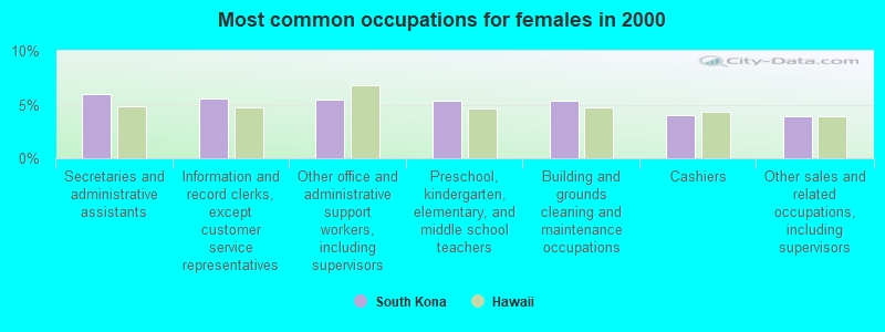
- Secretaries and administrative assistants (6.0%)
- Information and record clerks, except customer service representatives (5.6%)
- Other office and administrative support workers, including supervisors (5.4%)
- Preschool, kindergarten, elementary, and middle school teachers (5.4%)
- Building and grounds cleaning and maintenance occupations (5.4%)
- Cashiers (4.0%)
- Other sales and related occupations, including supervisors (4.0%)
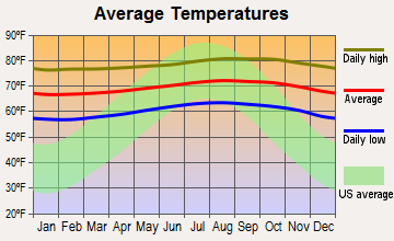
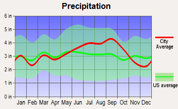
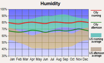
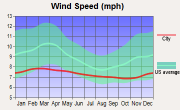
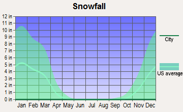
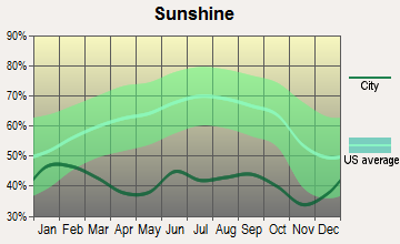
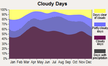
Average climate in South Kona, Hawaii
Based on data reported by over 4,000 weather stations
(lower is better)
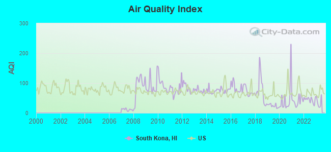
Air Quality Index (AQI) level in 2022 was 43.6. This is significantly better than average.
| City: | 43.6 |
| U.S.: | 72.6 |
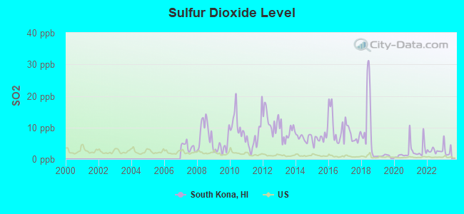
Sulfur Dioxide (SO2) [ppb] level in 2022 was 2.59. This is significantly worse than average. Closest monitor was 12.5 miles away from the city center.
| City: | 2.59 |
| U.S.: | 1.51 |
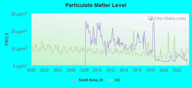
Particulate Matter (PM2.5) [µg/m3] level in 2022 was 5.12. This is significantly better than average. Closest monitor was 7.7 miles away from the city center.
| City: | 5.12 |
| U.S.: | 8.11 |
Earthquake activity:
South Kona-area historical earthquake activity is significantly above Hawaii state average. It is 2591% greater than the overall U.S. average.On 11/29/1975 at 14:47:40, a magnitude 7.2 (6.0 MB, 7.1 MS, 7.2 UK, 7.2 MS, Class: Major, Intensity: VIII - XII) earthquake occurred 55.8 miles away from South Kona center, causing 2 deaths (2 shaking deaths)
On 8/21/1951 at 10:57:00, a magnitude 6.9 (6.9 UK, Class: Strong, Intensity: VII - IX) earthquake occurred 29.9 miles away from the city center
On 5/4/2018 at 22:32:54, a magnitude 6.9 (6.9 MW, Depth: 3.6 mi) earthquake occurred 57.4 miles away from the city center
On 11/16/1983 at 16:13:00, a magnitude 6.7 (6.4 MB, 6.7 MS, 6.7 MW) earthquake occurred 33.7 miles away from South Kona center, causing $6,000,000 total damage
On 10/15/2006 at 17:07:49, a magnitude 6.7 (6.2 MB, 6.6 MS, 6.7 MW) earthquake occurred 37.2 miles away from South Kona center
On 10/15/2006 at 17:07:49, a magnitude 6.7 (6.7 MD, Depth: 23.7 mi) earthquake occurred 37.9 miles away from South Kona center
Magnitude types: body-wave magnitude (MB), duration magnitude (MD), surface-wave magnitude (MS), moment magnitude (MW)
Natural disasters:
The number of natural disasters in Hawaii County (21) is greater than the US average (15).Major Disasters (Presidential) Declared: 11
Causes of natural disasters: Fires: 7, Earthquakes: 4, Floods: 3, Storms: 3, Volcanic Eruptions: 3, Hurricanes: 2, Lava Flows: 2, High Surf: 1, Mudslide: 1, Tropical Storm: 1, Tsunami Wave: 1, Other: 1 (Note: some incidents may be assigned to more than one category).
Colleges/universities with over 2000 students nearest to South Kona:
- Hawaii Community College (about 58 miles; Hilo, HI; Full-time enrollment: 2,137)
- University of Hawaii at Hilo (about 58 miles; Hilo, HI; FT enrollment: 3,161)
- University of Hawaii Maui College (about 115 miles; Kahului, HI; FT enrollment: 2,492)
- Kapiolani Community College (about 184 miles; Honolulu, HI; FT enrollment: 5,069)
- Chaminade University of Honolulu (about 185 miles; Honolulu, HI; FT enrollment: 2,610)
- University of Hawaii at Manoa (about 185 miles; Honolulu, HI; FT enrollment: 16,461)
- Hawaii Pacific University (about 188 miles; Honolulu, HI; FT enrollment: 5,506)
Points of interest:
Notable locations in South Kona: Koa Mill (A), Cooks Heiau (B), Niuou Coconut Grove (C), Hikiau Heiau (D), Ahole Heiau (E), ‘Āhole Holua (F), Alahaka Heiau (G), ‘Āle‘ale‘a Heiau (H), Hale o Keawe Heiau (I), Holua Slide (J), Omao Heiau (K), Ka‘ohe Ranch (L), Opihihali (M), Napo‘opo‘o Lighthouse (N), Hooper Camp (O), Honomalino Camp (P), Hāpu‘u Camp (Q), Gaspars Dairy (R), Cooks Monument (S), Big Hill Camp (T). Display/hide their locations on the map
Shopping Center: Keopuka Square Shopping Center (1). Display/hide its location on the map
Churches in South Kona include: Christ Episcopal Church (A), Central Kona Union Church (B), Saint Benedicts Church (C), Puka‘ana Church (D), Kahikolu Church (E), Hau‘oli Kamana‘o Church (F). Display/hide their locations on the map
Cemetery: Kalahiki Cemetery (1). Display/hide its location on the map
Lakes: Holokaalele Pond (A), One Hundred Acre Waterhole (B), Komakawai Waterholes (C), Polewai Waterhole (D), Lumiawai Waterhole (E). Display/hide their locations on the map
Streams, rivers, and creeks: Ki‘ilae Watercourse (A). Display/hide its location on the map
Parks in South Kona include: Kealakekua Bay Park (1), Ho‘ōpūloa Church Monument (2), Ho‘okena Beach Park (3), Honaunau Rodeo Arena (4), Kipahoehoe State Natural Area Reserve (5), Milolii Beach Park (6), Hikiau Heiau State Monument (7), Pu‘uhonua o Hōnaunau National Historical Park (8). Display/hide their locations on the map
Beach: Keālia Beach (A). Display/hide its location on the map
| This place: | 2.7 people |
| Hawaii: | 2.9 people |
| This place: | 65.6% |
| Whole state: | 68.9% |
| This place: | 9.0% |
| Whole state: | 7.3% |
Likely homosexual households (counted as self-reported same-sex unmarried-partner households)
- Lesbian couples: 0.6% of all households
- Gay men: 0.5% of all households
| This place: | 12.7% |
| Whole state: | 10.7% |
| This place: | 6.3% |
| Whole state: | 5.0% |
People in group quarters in South Kona in 2010:
- 9 people in nursing facilities/skilled-nursing facilities
- 9 people in mental (psychiatric) hospitals and psychiatric units in other hospitals
- 5 people in hospitals with patients who have no usual home elsewhere
- 4 people in other noninstitutional facilities
3 people in homes for the mentally retarded in 2000
For population 15 years and over in South Kona:
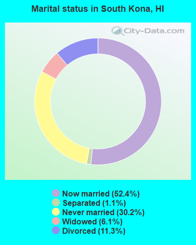
- Never married: 30.2%
- Now married: 52.4%
- Separated: 1.1%
- Widowed: 6.1%
- Divorced: 11.3%
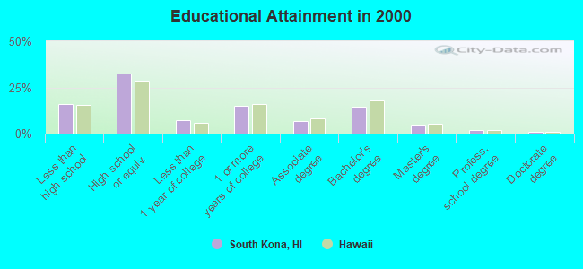
For population 25 years and over in South Kona:
- High school or higher: 84.1%
- Bachelor's degree or higher: 22.5%
- Graduate or professional degree: 8.0%
- Unemployed: 5.7%
- Mean travel time to work (commute): 24.5 minutes
| Here: | 12.3 |
| Hawaii average: | 12.8 |
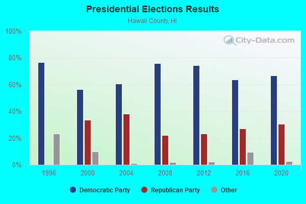
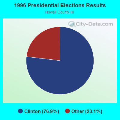
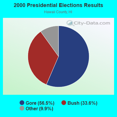
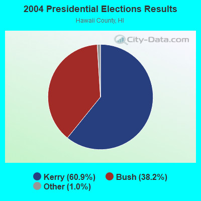

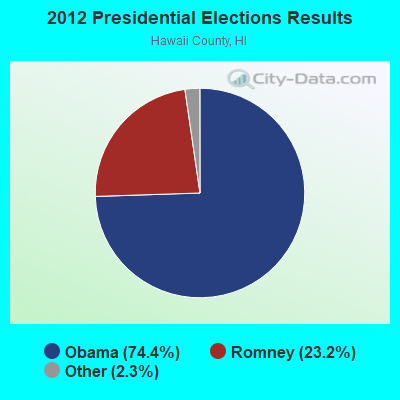
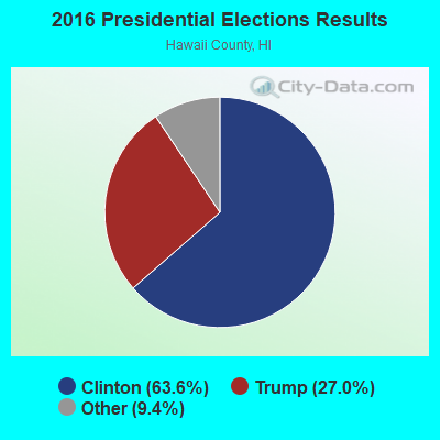
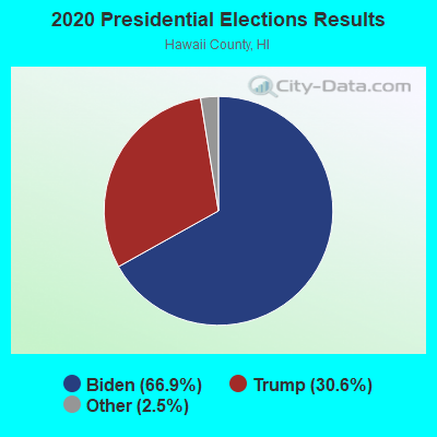
Graphs represent county-level data. Detailed 2008 Election Results
Neighborhoods in South Kona:
(South Kona, Hawaii Neighborhood Map)- 'Alika Homesteads neighborhood
- Alika Ahupua'a neighborhood
- Honokua Ahupua'a neighborhood
- Honomalino Ahupua'a (Kalihi Ahupua'a) neighborhood
- Hookena Ahupua'a neighborhood
- Kaapuna Ahupua'a neighborhood
- Kalahiki Ahupua'a neighborhood
- Kaohe 1-3 Ahupua'a neighborhood
- Kaohe 4 Ahupua'a neighborhood
- Kapua Ahupua'a neighborhood
- Kauleoli 1 2 Ahupua'a neighborhood
- Kealia 1 Ahupua'a neighborhood
- Kealia 2 Ahupua'a neighborhood
- Kipahoehoe Ahupua'a neighborhood
- Kukuiopa'e Homesteads neighborhood
- Kukuiopae 1 Ahupua'a (Kukuiopae 2 Ahupua'a) neighborhood
- Kukuiopae 2 Ahupua'a neighborhood
- Okeo 1 2 Ahupua'a neighborhood
- Olelomoana 2 Ahupua'a neighborhood
- Olelomoana 2 Ahupua'a (Opihihali 1 2 Ahupua'a) neighborhood
- Pahoehoe 1-4 Ahupua'a (Makuu Ahupua'a) neighborhood
- Pahoehoe 2 Ahupua'a neighborhood
- Papa 1 Ahupua'a neighborhood
- Papa 2 Ahupua'a neighborhood
- Waiea Ahupua'a neighborhood
Religion statistics for South Kona, HI (based on Hawaii County data)
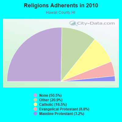
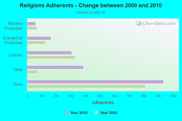
| Religion | Adherents | Congregations |
|---|---|---|
| Other | 38,701 | 88 |
| Catholic | 30,616 | 22 |
| Evangelical Protestant | 16,302 | 120 |
| Mainline Protestant | 5,882 | 43 |
| Orthodox | 25 | 1 |
| None | 93,553 | - |
Food Environment Statistics:
| This county: | 2.09 / 10,000 pop. |
| Hawaii: | 2.30 / 10,000 pop. |
| Hawaii County: | 0.06 / 10,000 pop. |
| Hawaii: | 0.09 / 10,000 pop. |
| Hawaii County: | 1.97 / 10,000 pop. |
| Hawaii: | 1.57 / 10,000 pop. |
| This county: | 2.55 / 10,000 pop. |
| Hawaii: | 1.72 / 10,000 pop. |
| Hawaii County: | 8.29 / 10,000 pop. |
| State: | 9.00 / 10,000 pop. |
| Hawaii County: | 7.1% |
| Hawaii: | 8.1% |
| Hawaii County: | 21.2% |
| Hawaii: | 20.8% |
| Here: | 10.3% |
| State: | 9.2% |
5.92% of this county's 2021 resident taxpayers lived in other counties in 2020 ($88,163 average adjusted gross income)
| Here: | 5.92% |
| Hawaii average: | 4.91% |
0.03% of residents moved from foreign countries ($348 average AGI)
Hawaii County: 0.03% Hawaii average: 0.19%
Top counties from which taxpayers relocated into this county between 2020 and 2021:
| from Honolulu County, HI | |
| from Maui County, HI | |
| from Los Angeles County, CA |
4.50% of this county's 2020 resident taxpayers moved to other counties in 2021 ($58,837 average adjusted gross income)
| Here: | 4.50% |
| Hawaii average: | 5.53% |
0.03% of residents moved to foreign countries ($272 average AGI)
Hawaii County: 0.03% Hawaii average: 0.15%
Top counties to which taxpayers relocated from this county between 2020 and 2021:
| to Honolulu County, HI | |
| to Clark County, NV | |
| to Maui County, HI |
Strongest AM radio stations in South Kona:
- KKON (790 AM; 5 kW; KEALAKEKUA, HI; Owner: BIG ISLAND RADIO ( HAWAII LIMITED PA)
- KPUA (670 AM; 10 kW; HILO, HI; Owner: NEW WEST BROADCASTING CORP.)
- KIPA (620 AM; 10 kW; NAALEHU, HI; Owner: BIG ISLAND RADIO)
- KUAU (1570 AM; 50 kW; HAIKU, HI; Owner: FIRST ASSEMBLY OF GOD-KAHULUI, MAUI)
- KAIM (870 AM; 50 kW; HONOLULU, HI; Owner: SALEM MEDIA OF HAWAII, INC.)
- KHLO (850 AM; 5 kW; HILO, HI; Owner: MAVERICK MEDIA OF HAWAII LICENSE, LLC)
- KHBC (1060 AM; 5 kW; HILO, HI; Owner: HILO BROADCASTING, L.L.C.)
- KMVI (550 AM; 5 kW; WAILUKU, HI; Owner: PACIFIC RADIO GROUP,INC.)
- KNUI (900 AM; 5 kW; KAHULUI, HI; Owner: PACIFIC RADIO GROUP, INC.)
- KORL (690 AM; 10 kW; HONOLULU, HI; Owner: NEW WAVE BROADCASTING, L.P.)
- KAOI (1110 AM; 5 kW; KIHEI, HI; Owner: VISIONARY RELATED ENTERTAINMENT, INC)
- KGU (760 AM; 10 kW; HONOLULU, HI; Owner: SALEM MEDIA OF HAWAII, INC.)
- KHNR (650 AM; 10 kW; HONOLULU, HI; Owner: SALEM MEDIA OF HAWAII, INC.)
Strongest FM radio stations in South Kona:
- KLEO (106.1 FM; KAHALUU, HI; Owner: MAVERICK MEDIA OF HAWAII LICENSE, LLC)
- KAGB (99.1 FM; WAIMEA, HI; Owner: BIG ISLAND RADIO)
- KLUA (93.9 FM; KAILUA KONA, HI; Owner: BIG ISLAND RADIO)
- KAOY (101.5 FM; KEALAKEKUA, HI; Owner: BIG ISLAND RADIO ( HAWAII LIMITED PA)
- KKUA (90.7 FM; WAILUKU, HI; Owner: HAWAII PUBLIC RADIO, INC.)
- KNUQ (103.7 FM; PAAUILO, HI; Owner: VISIONARY RELATED ENTERTAINMENT II,)
- KWYI (106.9 FM; KAWAIHAE, HI; Owner: COLIN H. NAITO)
FCC Registered Antenna Towers:
9 (See the full list of FCC Registered Antenna Towers in South Kona)FCC Registered Broadcast Land Mobile Towers:
1- Papa (Lat: 19.223667 Lon: -155.861111), Structure height: 8 m, Call Sign: WPBU837,
Assigned Frequencies: 153.425 MHz, Grant Date: 12/11/2012, Expiration Date: 03/10/2023, Cancellation Date: 09/25/2020, Registrant: Department Of Water Supply, County Of Hawaii, 889 Leilani St, Hilo, HI 96721, Phone: (808) 961-8790, Fax: (808) 961-8668, Email:
FCC Registered Microwave Towers:
1- HI72XC001, Capt Cook, Tmk (3) 8-1-001-026, Parcel 10 (Lat: 19.517028 Lon: -155.914583), Type: Tower, Structure height: 45.7 m, Overall height: 50.6 m, Call Sign: WQJF688,
Assigned Frequencies: 10578.7 MHz, Grant Date: 08/21/2008, Expiration Date: 08/21/2018, Cancellation Date: 09/10/2009, Certifier: Kyle B Entz, Registrant: Sprint Nextel Corporation, 2001 Edmund Halley Drive, Reston, VA 20191, Phone: (703) 433-4000, Fax: (703) 433-4142
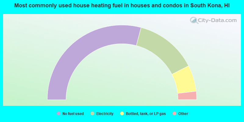
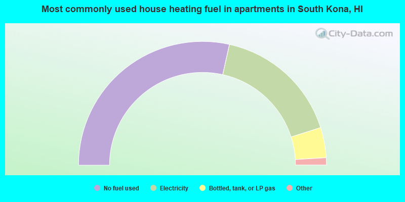
- 58.3%No fuel used
- 26.8%Electricity
- 11.4%Bottled, tank, or LP gas
- 2.5%Solar energy
- 1.0%Wood
- 57.0%No fuel used
- 33.2%Electricity
- 7.9%Bottled, tank, or LP gas
- 0.5%Other fuel
- 0.4%Fuel oil, kerosene, etc.
- 0.4%Wood
- 0.3%Utility gas
- 0.3%Solar energy
South Kona compared to Hawaii state average:
- Unemployed percentage below state average.
- Black race population percentage significantly below state average.
- Foreign-born population percentage significantly below state average.
- Length of stay since moving in significantly above state average.
- Number of rooms per house significantly below state average.
- House age significantly below state average.
South Kona on our top lists:
- #2 on the list of "Top 101 cities with largest percentage of males in occupations: farmers and farm managers (population 5,000+)"
- #13 on the list of "Top 101 cities with largest percentage of females in occupations: farmers and farm managers (population 5,000+)"
- #23 on the list of "Top 101 cities with largest percentage of females in industries: groceries and related products merchant wholesalers (population 5,000+)"
- #25 on the list of "Top 101 cities with largest percentage of females in industries: farm product raw materials merchant wholesalers (population 5,000+)"
- #34 on the list of "Top 101 cities with largest percentage of females in occupations: agricultural workers including supervisors (population 5,000+)"
- #48 on the list of "Top 101 cities with largest percentage of males in occupations: registered nurses (population 5,000+)"
- #53 on the list of "Top 101 cities with largest percentage of females in industries: gasoline stations (population 5,000+)"
- #57 on the list of "Top 101 cities with largest percentage of males in occupations: transportation, tourism, and lodging attendants (population 5,000+)"
- #64 on the list of "Top 101 cities with largest percentage of males in occupations: agricultural workers including supervisors (population 5,000+)"
- #69 on the list of "Top 101 larger cities with the lowest real estate taxes percentage (population 50,000+)"
- #72 on the list of "Top 101 cities with the highest percentage of workers working at home, population 5,000+"
- #81 on the list of "Top 101 cities with largest percentage of males in industries: book stores and news dealers (population 5,000+)"
- #88 on the list of "Top 101 cities with largest percentage of females in industries: other transportation, and support activities, and couriers (population 5,000+)"
- #93 (96704) on the list of "Top 101 zip codes with the largest percentage of Portuguese first ancestries"
- #1 on the list of "Top 101 counties with the highest Sulfur Oxides Annual air pollution readings in 2012 (µg/m3)"
- #27 on the list of "Top 101 counties with the lowest average weight of females"
- #50 on the list of "Top 101 counties with the highest percentage of residents that exercised in the past month"
- #59 on the list of "Top 101 counties with highest percentage of residents voting for Obama (Democrat) in the 2012 Presidential Election"
- #61 on the list of "Top 101 counties with the most Other congregations (pop. 50,000+)"