South Kohala, Hawaii
Submit your own pictures of this place and show them to the world
- OSM Map
- General Map
- Google Map
- MSN Map

| Males: 7,602 | |
| Females: 7,651 |
| Median resident age: | 36.2 years |
| Hawaii median age: | 36.2 years |
Zip code: 96738
| South Kohala: | $93,668 |
| HI: | $92,458 |
Estimated per capita income in 2022: $46,514 (it was $23,194 in 2000)
South Kohala CCD income, earnings, and wages data
Estimated median house or condo value in 2022: $702,415 (it was $203,800 in 2000)
| South Kohala: | $702,415 |
| HI: | $820,100 |
Mean prices in 2022: all housing units: $595,903; detached houses: $598,158; townhouses or other attached units: $648,474; in 2-unit structures: over $1,000,000; in 3-to-4-unit structures: $549,649; in 5-or-more-unit structures: $517,976; mobile homes: $220,909; occupied boats, rvs, vans, etc.: $401,772
Detailed information about poverty and poor residents in South Kohala, HI


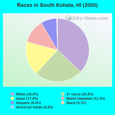
- 4,84336.9%White alone
- 3,26024.8%Two or more races
- 2,28317.4%Asian alone
- 1,61812.3%Native Hawaiian and Other
Pacific Islander alone - 1,0498.0%Hispanic
- 430.3%Black alone
- 230.2%American Indian alone
- 120.09%Other race alone
Races in South Kohala detailed stats: ancestries, foreign born residents, place of birth
 Recent articles from our blog. Our writers, many of them Ph.D. graduates or candidates, create easy-to-read articles on a wide variety of topics.

Current Local Time: HST (no DST) time zone
Land area: 351.7 square miles.
Population density: 43 people per square mile (very low).

| South Kohala CCD: | 0.3% ($600) |
| Hawaii: | 0.3% ($765) |
Nearest city with pop. 50,000+: Honolulu, HI  (164.7 miles , pop. 371,657).
Nearest city with pop. 1,000,000+: Los Angeles, CA (2482.2 miles , pop. 3,694,820).
Nearest cities:
), ), Latitude: 19.97 N, Longitude: 155.73 W

South Kohala tourist attractions:
| Here: | 2.6% |
| Hawaii: | 2.9% |
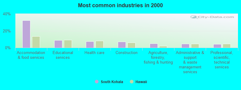
- Accommodation & food services (32.3%)
- Educational services (8.9%)
- Health care (7.5%)
- Construction (6.9%)
- Agriculture, forestry, fishing & hunting (4.9%)
- Administrative & support & waste management services (4.5%)
- Professional, scientific, technical services (4.4%)
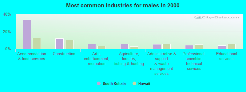
- Accommodation & food services (33.7%)
- Construction (11.9%)
- Arts, entertainment, recreation (5.7%)
- Agriculture, forestry, fishing & hunting (5.5%)
- Administrative & support & waste management services (5.4%)
- Professional, scientific, technical services (4.1%)
- Educational services (4.0%)
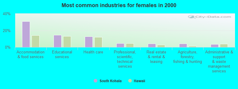
- Accommodation & food services (30.7%)
- Educational services (14.5%)
- Health care (12.7%)
- Professional, scientific, technical services (4.7%)
- Real estate & rental & leasing (4.3%)
- Agriculture, forestry, fishing & hunting (4.2%)
- Administrative & support & waste management services (3.5%)
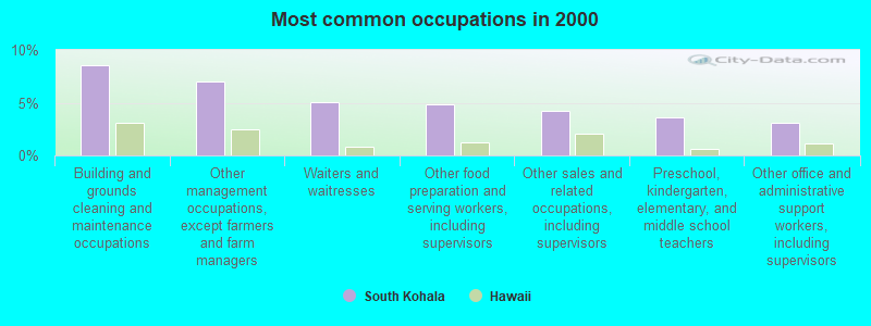
- Building and grounds cleaning and maintenance occupations (8.5%)
- Other management occupations, except farmers and farm managers (7.0%)
- Waiters and waitresses (5.1%)
- Other food preparation and serving workers, including supervisors (4.9%)
- Other sales and related occupations, including supervisors (4.3%)
- Preschool, kindergarten, elementary, and middle school teachers (3.6%)
- Other office and administrative support workers, including supervisors (3.1%)
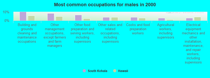
- Building and grounds cleaning and maintenance occupations (10.0%)
- Other management occupations, except farmers and farm managers (8.4%)
- Other food preparation and serving workers, including supervisors (6.5%)
- Other sales and related occupations, including supervisors (3.9%)
- Cooks and food preparation workers (3.9%)
- Agricultural workers, including supervisors (3.0%)
- Electrical equipment mechanics and other installation, maintenance, and repair workers, including supervisors (3.0%)
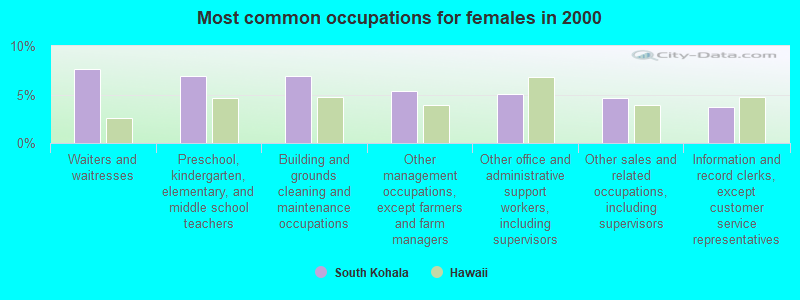
- Waiters and waitresses (7.6%)
- Preschool, kindergarten, elementary, and middle school teachers (7.0%)
- Building and grounds cleaning and maintenance occupations (6.9%)
- Other management occupations, except farmers and farm managers (5.4%)
- Other office and administrative support workers, including supervisors (5.1%)
- Other sales and related occupations, including supervisors (4.6%)
- Information and record clerks, except customer service representatives (3.7%)
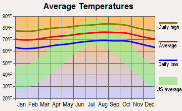
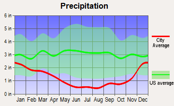
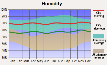
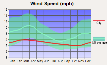
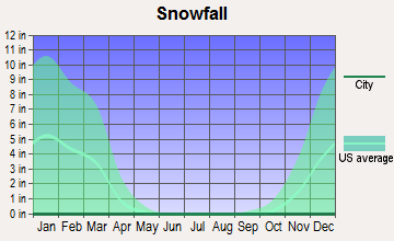
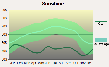
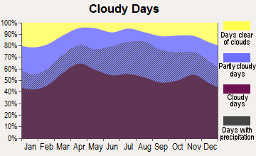
Average climate in South Kohala, Hawaii
Based on data reported by over 4,000 weather stations
(lower is better)
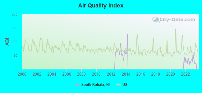
Air Quality Index (AQI) level in 2022 was 29.4. This is significantly better than average.
| City: | 29.4 |
| U.S.: | 72.6 |
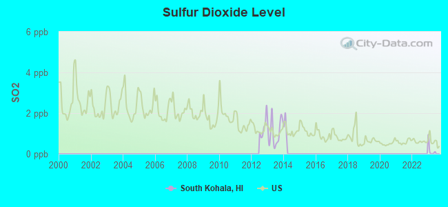
Sulfur Dioxide (SO2) [ppb] level in 2013 was 1.06. This is significantly better than average. Closest monitor was 4.8 miles away from the city center.
| City: | 1.06 |
| U.S.: | 1.51 |
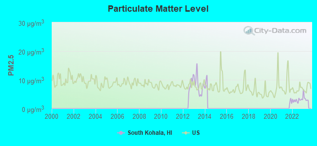
Particulate Matter (PM2.5) [µg/m3] level in 2022 was 2.84. This is significantly better than average. Closest monitor was 4.8 miles away from the city center.
| City: | 2.84 |
| U.S.: | 8.11 |
Earthquake activity:
South Kohala-area historical earthquake activity is significantly above Hawaii state average. It is 2461% greater than the overall U.S. average.On 11/29/1975 at 14:47:40, a magnitude 7.2 (6.0 MB, 7.1 MS, 7.2 UK, 7.2 MS, Class: Major, Intensity: VIII - XII) earthquake occurred 57.3 miles away from the city center, causing 2 deaths (2 shaking deaths)
On 8/21/1951 at 10:57:00, a magnitude 6.9 (6.9 UK, Class: Strong, Intensity: VII - IX) earthquake occurred 23.3 miles away from the city center
On 5/4/2018 at 22:32:54, a magnitude 6.9 (6.9 MW, Depth: 3.6 mi) earthquake occurred 65.1 miles away from the city center
On 10/15/2006 at 17:07:49, a magnitude 6.7 (6.7 MD, Depth: 23.7 mi) earthquake occurred 14.9 miles away from South Kohala center
On 10/15/2006 at 17:07:49, a magnitude 6.7 (6.2 MB, 6.6 MS, 6.7 MW) earthquake occurred 18.7 miles away from the city center
On 11/16/1983 at 16:13:00, a magnitude 6.7 (6.4 MB, 6.7 MS, 6.7 MW) earthquake occurred 43.0 miles away from the city center, causing $6,000,000 total damage
Magnitude types: body-wave magnitude (MB), duration magnitude (MD), surface-wave magnitude (MS), moment magnitude (MW)
Natural disasters:
The number of natural disasters in Hawaii County (21) is greater than the US average (15).Major Disasters (Presidential) Declared: 11
Causes of natural disasters: Fires: 7, Earthquakes: 4, Floods: 3, Storms: 3, Volcanic Eruptions: 3, Hurricanes: 2, Lava Flows: 2, High Surf: 1, Mudslide: 1, Tropical Storm: 1, Tsunami Wave: 1, Other: 1 (Note: some incidents may be assigned to more than one category).
Colleges/universities with over 2000 students nearest to South Kohala:
- University of Hawaii at Hilo (about 46 miles; Hilo, HI; Full-time enrollment: 3,161)
- Hawaii Community College (about 46 miles; Hilo, HI; FT enrollment: 2,137)
- University of Hawaii Maui College (about 81 miles; Kahului, HI; FT enrollment: 2,492)
- Kapiolani Community College (about 162 miles; Honolulu, HI; FT enrollment: 5,069)
- Chaminade University of Honolulu (about 163 miles; Honolulu, HI; FT enrollment: 2,610)
- University of Hawaii at Manoa (about 164 miles; Honolulu, HI; FT enrollment: 16,461)
- Hawaii Pacific University (about 167 miles; Honolulu, HI; FT enrollment: 5,506)
Points of interest:
Notable locations in South Kohala: Kawaihae Uka (A), Pu‘ukoholā Heiau (B), Old Aalii Pump Station (C), Pa Aalii Pump Station (D), Pakila Pump Station (E), Waiki‘i Pump Station (F), Kawaihae Light (G), Parker Ranch (H), Parker Ranch Racetrack (I), Pelekane (J), Poo Kanaka (K), Papakonani Boat Landing (L), Puu Anahulu Homesteads (M), Hale-ō-ka-puni Heiau (N), Mailekini Heiau (O), The Stone Leaning Post (P), Pelekāne (Q), Kamuela Museum (R), Waikii Volunteer Fire Station 09A (S), Hawaii County Fire Department Station 16 Waikoloa (T). Display/hide their locations on the map
Shopping Centers: Opelo Plaza Shopping Center (1), Parker Ranch Shopping Center (2), Parker Square Mall Shopping Center (3), Waimea Shopping Center (4). Display/hide their locations on the map
Churches in South Kohala include: Imiola Church (A), Hokuloa Church (B). Display/hide their locations on the map
Cemetery: Imiola Church Cemetery (1). Display/hide its location on the map
Reservoirs: Waipuhi Fishpond (A), Paiakuli Reservoir (B), Waikoloa Reservoir Number 1 (C), Kahapapa Fishpond (D), Waimea Reservoir (E), Waikoloa Reservoir Number 2 (F), Puukapu Reservoir (G), Hopeaia Fishpond (H). Display/hide their locations on the map
Streams, rivers, and creeks: Kohakohau Stream (A), Kawaiki Stream (B), Keanuiomano Stream (C), Keawewai Stream (D), Waikoloa Stream (E), Lanimaumau Stream (F). Display/hide their locations on the map
Parks in South Kohala include: Pu‘ukoholā Heiau National Historic Site (1), Waimea Park (2), Pu‘uke‘eke‘e Game Management Area (3), Spencer Beach Park (4), Hapuna Beach State Park (5), Waikii Paddock Game Management Area (6). Display/hide their locations on the map
Beaches: Ohaiula Beach (A), Kaunaoa Beach (B), Waikui Beach (C), Mauumae Beach (D), Kaluhikaa Beach (E), Waialea Beach (F). Display/hide their locations on the map
| This place: | 2.7 people |
| Hawaii: | 2.9 people |
| This place: | 70.0% |
| Whole state: | 68.9% |
| This place: | 10.3% |
| Whole state: | 7.3% |
Likely homosexual households (counted as self-reported same-sex unmarried-partner households)
- Lesbian couples: 0.7% of all households
- Gay men: 0.5% of all households
| This place: | 8.5% |
| Whole state: | 10.7% |
| This place: | 4.6% |
| Whole state: | 5.0% |
People in group quarters in South Kohala in 2010:
- 149 people in workers' group living quarters and job corps centers
- 55 people in other noninstitutional facilities
- 39 people in college/university student housing
- 7 people in group homes intended for adults
7 people in other noninstitutional group quarters in 2000
For population 15 years and over in South Kohala:
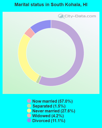
- Never married: 27.6%
- Now married: 57.0%
- Separated: 1.5%
- Widowed: 4.2%
- Divorced: 11.1%
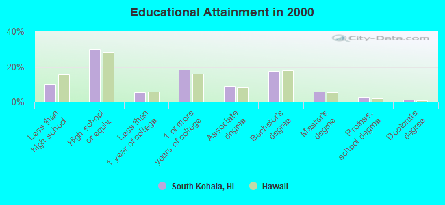
For population 25 years and over in South Kohala:
- High school or higher: 90.1%
- Bachelor's degree or higher: 27.4%
- Graduate or professional degree: 9.8%
- Unemployed: 3.3%
- Mean travel time to work (commute): 23.6 minutes
| Here: | 10.5 |
| Hawaii average: | 12.8 |
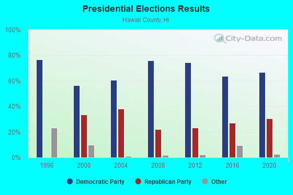
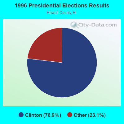
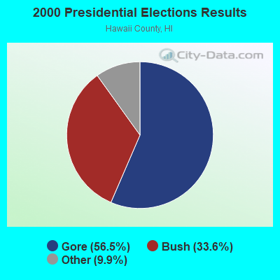
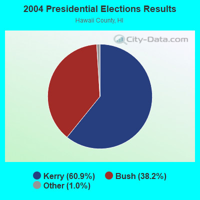

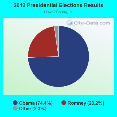
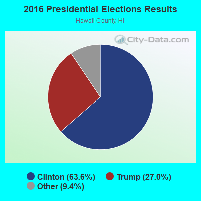
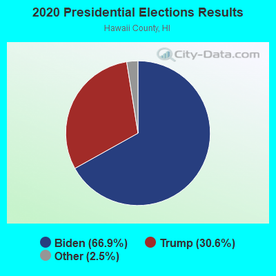
Graphs represent county-level data. Detailed 2008 Election Results
Religion statistics for South Kohala, HI (based on Hawaii County data)
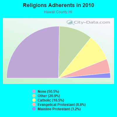
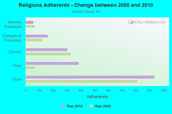
| Religion | Adherents | Congregations |
|---|---|---|
| Other | 38,701 | 88 |
| Catholic | 30,616 | 22 |
| Evangelical Protestant | 16,302 | 120 |
| Mainline Protestant | 5,882 | 43 |
| Orthodox | 25 | 1 |
| None | 93,553 | - |
Food Environment Statistics:
| This county: | 2.09 / 10,000 pop. |
| Hawaii: | 2.30 / 10,000 pop. |
| Hawaii County: | 0.06 / 10,000 pop. |
| State: | 0.09 / 10,000 pop. |
| This county: | 1.97 / 10,000 pop. |
| Hawaii: | 1.57 / 10,000 pop. |
| This county: | 2.55 / 10,000 pop. |
| State: | 1.72 / 10,000 pop. |
| This county: | 8.29 / 10,000 pop. |
| Hawaii: | 9.00 / 10,000 pop. |
| Hawaii County: | 7.1% |
| State: | 8.1% |
| Hawaii County: | 21.2% |
| Hawaii: | 20.8% |
| Hawaii County: | 10.3% |
| Hawaii: | 9.2% |
5.92% of this county's 2021 resident taxpayers lived in other counties in 2020 ($88,163 average adjusted gross income)
| Here: | 5.92% |
| Hawaii average: | 4.91% |
0.03% of residents moved from foreign countries ($348 average AGI)
Hawaii County: 0.03% Hawaii average: 0.19%
Top counties from which taxpayers relocated into this county between 2020 and 2021:
| from Honolulu County, HI | |
| from Maui County, HI | |
| from Los Angeles County, CA |
4.50% of this county's 2020 resident taxpayers moved to other counties in 2021 ($58,837 average adjusted gross income)
| Here: | 4.50% |
| Hawaii average: | 5.53% |
0.03% of residents moved to foreign countries ($272 average AGI)
Hawaii County: 0.03% Hawaii average: 0.15%
Top counties to which taxpayers relocated from this county between 2020 and 2021:
| to Honolulu County, HI | |
| to Clark County, NV | |
| to Maui County, HI |
Strongest AM radio stations in South Kohala:
- KIPA (620 AM; 10 kW; NAALEHU, HI; Owner: BIG ISLAND RADIO)
- KPUA (670 AM; 10 kW; HILO, HI; Owner: NEW WEST BROADCASTING CORP.)
- KUAU (1570 AM; 50 kW; HAIKU, HI; Owner: FIRST ASSEMBLY OF GOD-KAHULUI, MAUI)
- KKON (790 AM; 5 kW; KEALAKEKUA, HI; Owner: BIG ISLAND RADIO ( HAWAII LIMITED PA)
- KAIM (870 AM; 50 kW; HONOLULU, HI; Owner: SALEM MEDIA OF HAWAII, INC.)
- KHLO (850 AM; 5 kW; HILO, HI; Owner: MAVERICK MEDIA OF HAWAII LICENSE, LLC)
- KHBC (1060 AM; 5 kW; HILO, HI; Owner: HILO BROADCASTING, L.L.C.)
- KMVI (550 AM; 5 kW; WAILUKU, HI; Owner: PACIFIC RADIO GROUP,INC.)
- KNUI (900 AM; 5 kW; KAHULUI, HI; Owner: PACIFIC RADIO GROUP, INC.)
- KAOI (1110 AM; 5 kW; KIHEI, HI; Owner: VISIONARY RELATED ENTERTAINMENT, INC)
- KORL (690 AM; 10 kW; HONOLULU, HI; Owner: NEW WAVE BROADCASTING, L.P.)
- KGU (760 AM; 10 kW; HONOLULU, HI; Owner: SALEM MEDIA OF HAWAII, INC.)
- KHNR (650 AM; 10 kW; HONOLULU, HI; Owner: SALEM MEDIA OF HAWAII, INC.)
Strongest FM radio stations in South Kohala:
- KWYI (106.9 FM; KAWAIHAE, HI; Owner: COLIN H. NAITO)
- KAGB (99.1 FM; WAIMEA, HI; Owner: BIG ISLAND RADIO)
- KLUA (93.9 FM; KAILUA KONA, HI; Owner: BIG ISLAND RADIO)
- KAOY (101.5 FM; KEALAKEKUA, HI; Owner: BIG ISLAND RADIO ( HAWAII LIMITED PA)
- KLEO (106.1 FM; KAHALUU, HI; Owner: MAVERICK MEDIA OF HAWAII LICENSE, LLC)
- KNUQ (103.7 FM; PAAUILO, HI; Owner: VISIONARY RELATED ENTERTAINMENT II,)
- KKUA (90.7 FM; WAILUKU, HI; Owner: HAWAII PUBLIC RADIO, INC.)
- K220HA (91.9 FM; KIHEI, HI; Owner: CALVARY CHAPEL OF TWIN FALLS, INC.)
- K210CM (89.9 FM; KIHEI, HI; Owner: CALVARY CHAPEL OF TWIN FALLS, INC.)
- KJMD (98.3 FM; PUKALANI, HI; Owner: PACIFIC RADIO GROUP,INC.)
- KONI (104.7 FM; LANAI CITY, HI; Owner: HOCHMAN HAWAII PUBLISHING, INC.)
- KLHI-FM (101.1 FM; LAHAINA, HI; Owner: PACIFIC RADIO GROUP, INC.)
- KNUI-FM (99.9 FM; KAHULUI, HI; Owner: PACIFIC RADIO GROUP, INC.)
FCC Registered Broadcast Land Mobile Towers:
2- Atop Sheraton Royal Waikoloa Hotel (Lat: 19.944722 Lon: -155.842778), Call Sign: KNBB235, Licensee ID: L00039538,
Assigned Frequencies: 151.895 MHz, Grant Date: 07/18/1996, Expiration Date: 08/21/2001, Cancellation Date: 10/21/2001, Registrant: Waikoloa Inc, Waikoloa, HI 96743, Phone: (808) 885-1000
- Lat: 20.108583 Lon: -155.713861, Call Sign: WPWI740,
Assigned Frequencies: 451.187 MHz, 451.237 MHz, 451.312 MHz, 451.362 MHz, 451.687 MHz, Grant Date: 11/25/2002, Expiration Date: 11/25/2012, Cancellation Date: 01/26/2013, Certifier: Les Chess, Registrant: Cara Enterprises Inc, Salt Lake City, UT 84117-0503, Phone: (801) 278-9728, Fax: (801) 278-7239
FCC Registered Microwave Towers:
5- MAUNALANI, Maunalani Swtchng Sta Lalamilo Windfarm Svc Access Rd (Lat: 19.975000 Lon: -155.819139), Type: Tower, Structure height: 13.7 m, Call Sign: WNTM615,
Assigned Frequencies: 2477.25 MHz, Grant Date: 03/25/2022, Expiration Date: 06/18/2032, Registrant: Utility Telecom Consulting Group, Inc., 1554 Saint Paul Street, Denver, CO 80206, Phone: (303) 840-1041, Email:
- SOUTH KOHAL, S Kohala Switching Sta Rd C (Lat: 20.002222 Lon: -155.798889), Type: Tower, Structure height: 13.7 m, Call Sign: WNTM619,
Assigned Frequencies: 2469.75 MHz, Grant Date: 04/23/2002, Expiration Date: 06/18/2012, Cancellation Date: 08/18/2012, Registrant: Comsearch, 19700 Janelia Farm Boulevard, Ashburn, VA 20147, Phone: (703) 726-5671, Fax: (703) 726-5595, Email:
- South Kohala, South Kohala Switching Station, Road C (Lat: 20.002222 Lon: -155.798889), Type: Ltower, Structure height: 13.7 m, Call Sign: WQWR804,
Assigned Frequencies: 2469.75 MHz, Grant Date: 11/02/2015, Expiration Date: 11/02/2025, Certifier: Thomas Cummins, Registrant: Utility Telecom Consulting Group, Inc., 9850 S. Maryland Parkway, Suite A5-108, Las Vegas, NV 89183, Phone: (303) 840-1041, Email:
- OULI, S Kohala Switching Sta Rd C (Lat: 20.003083 Lon: -155.797083), Type: Ltower, Structure height: 13.7 m, Overall height: 15.2 m, Call Sign: WRDX692,
Assigned Frequencies: 6887.50 MHz, Grant Date: 08/14/2019, Expiration Date: 08/14/2029, Certifier: Dave Okamura, Registrant: Utility Telecom Consulting Group, Inc., 9850 S. Maryland Parkway Suite A5-108, Las Vegas, NV 89183, Phone: (970) 672-0075, Email:
- MAUNA LANI, Maunalani Swtchng Sta Lalamilo Windfarm Svc Access Rd (Lat: 19.974444 Lon: -155.818917), Type: Ltower, Structure height: 13.7 m, Overall height: 15.2 m, Call Sign: WRDX693,
Assigned Frequencies: 6937.50 MHz, Grant Date: 08/14/2019, Expiration Date: 08/14/2029, Certifier: Dave Okamura, Registrant: Utility Telecom Consulting Group, Inc., 9850 S. Maryland Parkway Suite A5-108, Las Vegas, NV 89183, Phone: (970) 672-0075, Email:
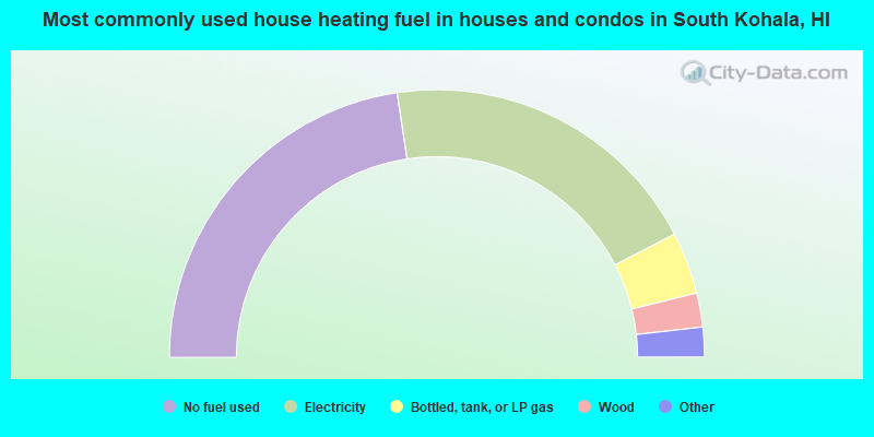
- 45.2%No fuel used
- 39.5%Electricity
- 7.5%Bottled, tank, or LP gas
- 4.1%Wood
- 2.6%Solar energy
- 0.6%Utility gas
- 0.4%Other fuel
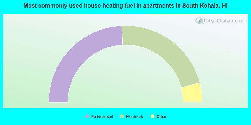
- 48.5%No fuel used
- 43.4%Electricity
- 3.6%Wood
- 3.5%Bottled, tank, or LP gas
- 0.9%Utility gas
- 0.2%Solar energy
South Kohala compared to Hawaii state average:
- Unemployed percentage significantly below state average.
- Black race population percentage significantly below state average.
- Foreign-born population percentage significantly below state average.
- Length of stay since moving in significantly above state average.
- Number of rooms per house significantly below state average.
- House age significantly below state average.
- Number of college students below state average.
South Kohala on our top lists:
- #2 on the list of "Top 101 cities with largest percentage of males in occupations: other food preparation and serving workers including supervisors (population 5,000+)"
- #4 on the list of "Top 101 cities with largest percentage of males in occupations: waiters and waitresses (population 5,000+)"
- #5 on the list of "Top 101 cities with largest percentage of females in occupations: waiters and waitresses (population 5,000+)"
- #7 on the list of "Top 101 cities with largest percentage of males in occupations: entertainers and performers, sports, and related workers (population 5,000+)"
- #9 on the list of "Top 101 cities with largest percentage of males in occupations: transportation, tourism, and lodging attendants (population 5,000+)"
- #9 on the list of "Top 101 cities with largest percentage of females in industries: accommodation and food services (population 5,000+)"
- #10 on the list of "Top 101 cities with largest percentage of males in industries: accommodation and food services (population 5,000+)"
- #20 on the list of "Top 101 cities with largest percentage of males in occupations: food and beverage serving workers except waiters/waitresses (population 5,000+)"
- #31 on the list of "Top 101 cities with largest percentage of females in industries: jewelry, luggage, and leather goods stores (population 5,000+)"
- #41 on the list of "Top 101 cities with largest percentage of males in industries: sewing, needlework, and piece goods stores (population 5,000+)"
- #75 on the list of "Top 101 larger cities with the lowest real estate taxes percentage (population 50,000+)"
- #95 on the list of "Top 101 cities with the largest percentage of people in unknown juvenile institutions (population 1,000+)"
- #1 on the list of "Top 101 counties with the highest Sulfur Oxides Annual air pollution readings in 2012 (µg/m3)"
- #27 on the list of "Top 101 counties with the lowest average weight of females"
- #50 on the list of "Top 101 counties with the highest percentage of residents that exercised in the past month"
- #59 on the list of "Top 101 counties with highest percentage of residents voting for Obama (Democrat) in the 2012 Presidential Election"
- #61 on the list of "Top 101 counties with the most Other congregations (pop. 50,000+)"