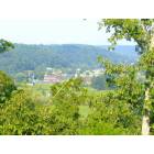
South Fork, Kentucky
Submit your own pictures of this place and show them to the world
- OSM Map
- General Map
- Google Map
- MSN Map

| Males: 683 | |
| Females: 633 |
| Median resident age: | 37.7 years |
| Kentucky median age: | 35.9 years |
Zip code: 40437
| South Fork: | $44,406 |
| KY: | $59,341 |
Estimated per capita income in 2022: $23,488 (it was $12,977 in 2000)
South Fork CCD income, earnings, and wages data
Estimated median house or condo value in 2022: $163,082 (it was $54,300 in 2000)
| South Fork: | $163,082 |
| KY: | $196,300 |
Mean prices in 2022: all housing units: $145,827; detached houses: $175,931; townhouses or other attached units: $75,954; mobile homes: $51,373
Detailed information about poverty and poor residents in South Fork, KY


- 1,20696.4%White alone
- 191.5%Two or more races
- 181.4%Hispanic
- 40.3%American Indian alone
- 20.2%Other race alone
- 10.08%Black alone
- 10.08%Asian alone

Races in South Fork detailed stats: ancestries, foreign born residents, place of birth
 Recent articles from our blog. Our writers, many of them Ph.D. graduates or candidates, create easy-to-read articles on a wide variety of topics.
Current Local Time: EST time zone
Elevation: 968 feet
Land area: 91.7 square miles.
Population density: 14 people per square mile (very low).

| South Fork CCD: | 0.6% ($318) |
| Kentucky: | 0.8% ($610) |
Nearest city with pop. 50,000+: Fayette, KY  (45.9 miles , pop. 260,512).
Nearest city with pop. 1,000,000+: Chicago, IL (335.3 miles , pop. 2,896,016).
Nearest cities:
), ), ), ), ), Latitude: 37.47 N, Longitude: 84.95 W


| Here: | 3.8% |
| Kentucky: | 3.8% |

- Educational services (11.9%)
- Agriculture, forestry, fishing & hunting (10.8%)
- Health care (8.6%)
- Machinery (7.7%)
- Construction (6.4%)
- Accommodation & food services (6.2%)
- Department & other general merchandise stores (5.7%)

- Agriculture, forestry, fishing & hunting (15.8%)
- Machinery (12.6%)
- Construction (10.4%)
- Accommodation & food services (8.3%)
- Educational services (6.5%)
- Motor vehicle & parts dealers (5.4%)
- Building material & garden equipment & supplies dealers (5.4%)

- Educational services (20.6%)
- Health care (18.3%)
- Department & other general merchandise stores (11.4%)
- Miscellaneous manufacturing (8.6%)
- Publishing, motion picture & sound recording industries (6.3%)
- Finance & insurance (5.1%)
- Printing & related support activities (4.0%)

- Metal workers and plastic workers (7.5%)
- Other sales and related occupations, including supervisors (7.3%)
- Other production occupations, including supervisors (6.6%)
- Farmers and farm managers (6.2%)
- Vehicle and mobile equipment mechanics, installers, and repairers (5.3%)
- Laborers and material movers, hand (4.6%)
- Preschool, kindergarten, elementary, and middle school teachers (4.4%)

- Metal workers and plastic workers (10.4%)
- Farmers and farm managers (10.1%)
- Vehicle and mobile equipment mechanics, installers, and repairers (8.6%)
- Other production occupations, including supervisors (8.6%)
- Supervisors, construction and extraction workers (5.4%)
- Laborers and material movers, hand (5.4%)
- Other sales and related occupations, including supervisors (5.0%)

- Preschool, kindergarten, elementary, and middle school teachers (11.4%)
- Other sales and related occupations, including supervisors (10.9%)
- Assemblers and fabricators (10.9%)
- Cooks and food preparation workers (9.1%)
- Other healthcare support occupations (6.9%)
- Financial managers (5.1%)
- Nursing, psychiatric, and home health aides (4.6%)
Average climate in South Fork, Kentucky
Based on data reported by over 4,000 weather stations


Tornado activity:
South Fork-area historical tornado activity is near Kentucky state average. It is 34% greater than the overall U.S. average.
On 4/3/1974, a category F4 (max. wind speeds 207-260 mph) tornado 13.7 miles away from the South Fork place center injured 56 people and caused between $500,000 and $5,000,000 in damages.
On 4/27/1971, a category F4 tornado 27.4 miles away from the place center killed 6 people and injured 58 people.
Earthquake activity:
South Fork-area historical earthquake activity is significantly above Kentucky state average. It is 98% greater than the overall U.S. average.On 7/27/1980 at 18:52:21, a magnitude 5.2 (5.1 MB, 4.7 MS, 5.0 UK, 5.2 UK, Class: Moderate, Intensity: VI - VII) earthquake occurred 74.8 miles away from South Fork center
On 4/18/2008 at 09:36:59, a magnitude 5.4 (5.1 MB, 4.8 MS, 5.4 MW, 5.2 MW) earthquake occurred 174.0 miles away from the city center
On 4/18/2008 at 09:36:59, a magnitude 5.2 (5.2 MW, Depth: 8.9 mi) earthquake occurred 174.0 miles away from the city center
On 9/7/1988 at 02:28:09, a magnitude 4.6 (4.5 MB, 4.6 LG, Class: Light, Intensity: IV - V) earthquake occurred 74.7 miles away from the city center
On 6/18/2002 at 17:37:15, a magnitude 5.0 (4.3 MB, 4.6 MW, 5.0 LG) earthquake occurred 159.0 miles away from the city center
On 6/10/1987 at 23:48:54, a magnitude 5.1 (4.9 MB, 4.4 MS, 4.6 MS, 5.1 LG) earthquake occurred 185.0 miles away from the city center
Magnitude types: regional Lg-wave magnitude (LG), body-wave magnitude (MB), surface-wave magnitude (MS), moment magnitude (MW)
Natural disasters:
The number of natural disasters in Casey County (23) is greater than the US average (15).Major Disasters (Presidential) Declared: 18
Emergencies Declared: 3
Causes of natural disasters: Floods: 14, Storms: 13, Tornadoes: 7, Winter Storms: 6, Mudslides: 4, Winds: 3, Landslides: 2, Blizzard: 1, Freeze: 1, Hurricane: 1, Snow: 1, Snowfall: 1, Snowstorm: 1, Other: 1 (Note: some incidents may be assigned to more than one category).
Hospitals and medical centers near South Fork:
- CASEY COUNTY HOSPITAL Critical Access Hospitals (about 11 miles away; LIBERTY, KY)
- GOLDEN LIVINGCENTER-STANFORD (Nursing Home, about 14 miles away; STANFORD, KY)
- MCDOWELL HOME HEALTH AGENCY (Home Health Center, about 15 miles away; DANVILLE, KY)
- FMC - DANVILLE (Dialysis Facility, about 15 miles away; DANVILLE, KY)
- DCI - DANVILLE (Dialysis Facility, about 16 miles away; DANVILLE, KY)
- CHARLESTON HEALTH CARE CENTER (Nursing Home, about 16 miles away; DANVILLE, KY)
- FORT LOGAN HOSPITAL EXTENDED CARE (Nursing Home, about 16 miles away; STANFORD, KY)
Colleges/universities with over 2000 students nearest to South Fork:
- Campbellsville University (about 24 miles; Campbellsville, KY; Full-time enrollment: 2,948)
- Lindsey Wilson College (about 33 miles; Columbia, KY; FT enrollment: 2,552)
- Somerset Community College (about 34 miles; Somerset, KY; FT enrollment: 4,698)
- Eastern Kentucky University (about 41 miles; Richmond, KY; FT enrollment: 13,525)
- Bluegrass Community and Technical College (about 46 miles; Lexington, KY; FT enrollment: 8,560)
- University of Kentucky (about 46 miles; Lexington, KY; FT enrollment: 23,517)
- Kentucky State University (about 51 miles; Frankfort, KY; FT enrollment: 2,112)
Points of interest:
Notable location: Butchertown Community Center (A). Display/hide its location on the map
Churches in South Fork include: Frey Creek Church (A), Friendship Church (B), Piedmont Church (C), Valley Grove Church (D). Display/hide their locations on the map
Cemeteries: Malone Cemetery (1), Brown Cemetery (2), Peyton Cemetery (3), Adam Cemetery (4), Vaught Cemetery (5), Whitehouse Cemetery (6), Elder Cemetery (7). Display/hide their locations on the map
Streams, rivers, and creeks: Black Lick Branch (A), Wolf Pen Branch (B), Cox Branch (C), Cooley Branch (D), Coffman Branch (E), Sulphur Branch (F), McAnelly Branch (G), Martin Creek (H), Murphy Branch (I). Display/hide their locations on the map
| This place: | 2.5 people |
| Kentucky: | 2.5 people |
| This place: | 60.8% |
| Whole state: | 69.8% |
| This place: | 5.2% |
| Whole state: | 4.5% |
Likely homosexual households (counted as self-reported same-sex unmarried-partner households)
- Lesbian couples: 0.2% of all households
- Gay men: 0.6% of all households
| This place: | 22.2% |
| Whole state: | 15.8% |
| This place: | 11.7% |
| Whole state: | 6.6% |
For population 15 years and over in South Fork:

- Never married: 19.8%
- Now married: 65.7%
- Separated: 2.8%
- Widowed: 7.3%
- Divorced: 7.2%
For population 25 years and over in South Fork:
- High school or higher: 49.9%
- Bachelor's degree or higher: 10.8%
- Graduate or professional degree: 2.5%
- Unemployed: 10.1%
- Mean travel time to work (commute): 25.6 minutes


| Here: | 19.1 |
| Kentucky average: | 13.8 |
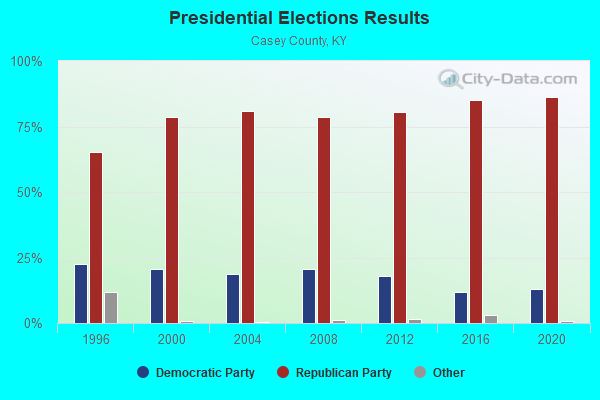
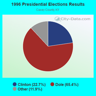
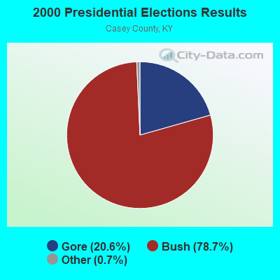
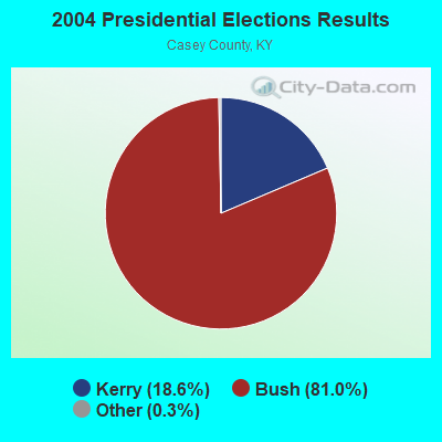
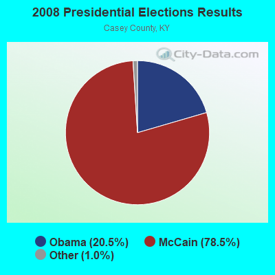
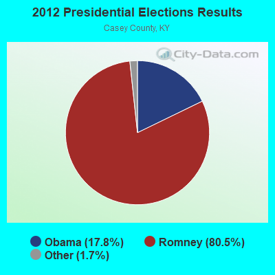
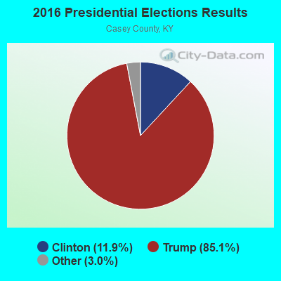

Graphs represent county-level data. Detailed 2008 Election Results
Religion statistics for South Fork, KY (based on Casey County data)
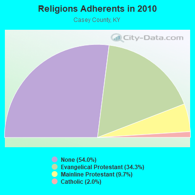
| Religion | Adherents | Congregations |
|---|---|---|
| Evangelical Protestant | 5,470 | 46 |
| Mainline Protestant | 1,554 | 13 |
| Catholic | 312 | 2 |
| Other | 2 | - |
| None | 8,617 | - |
Food Environment Statistics:
| Casey County: | 4.34 / 10,000 pop. |
| Kentucky: | 2.19 / 10,000 pop. |
| Casey County: | 2.48 / 10,000 pop. |
| Kentucky: | 0.74 / 10,000 pop. |
| Casey County: | 6.82 / 10,000 pop. |
| State: | 4.36 / 10,000 pop. |
| Here: | 3.72 / 10,000 pop. |
| State: | 5.74 / 10,000 pop. |
| Casey County: | 12.7% |
| Kentucky: | 11.0% |
| Casey County: | 31.2% |
| State: | 30.0% |
| This county: | 15.1% |
| State: | 15.9% |
Strongest AM radio stations in South Fork:
- WHAS (840 AM; 50 kW; LOUISVILLE, KY; Owner: CLEAR CHANNEL BROADCASTING LICENSES, INC.)
- WDFB (1170 AM; daytime; 1 kW; JUNCTION CITY, KY; Owner: ALUM SPRINGS VISION & OUTREACH CORP)
- WKDO (1560 AM; daytime; 1 kW; LIBERTY, KY; Owner: CARLOS WESLEY)
- WKVL (850 AM; daytime; 50 kW; KNOXVILLE, TN; Owner: HORNE RADIO, LLC)
- WLW (700 AM; 50 kW; CINCINNATI, OH; Owner: JACOR BROADCASTING CORPORATION)
- WSM (650 AM; 50 kW; NASHVILLE, TN; Owner: GAYLORD ENTERTAINMENT COMPANY)
- WVLK (590 AM; 5 kW; LEXINGTON, KY; Owner: CUMULUS LICENSING CORP.)
- WHIR (1230 AM; 1 kW; DANVILLE, KY; Owner: HOMETOWN B/CSTNG OF DANVILLE, INC.)
- WLAP (630 AM; 5 kW; LEXINGTON, KY; Owner: CITICASTERS LICENSES, L.P.)
- WSAI (1530 AM; 50 kW; CINCINNATI, OH; Owner: JACOR BROADCASTING CORPORATION)
- WAMB (1160 AM; 50 kW; DONELSON, TN; Owner: GREAT SOUTHERN BROADCASTING COMPANY, INC.)
- WXRA (1580 AM; 10 kW; GEORGETOWN, KY; Owner: CITICASTERS LICENSES, L.P.)
- WTVN (610 AM; 50 kW; COLUMBUS, OH; Owner: CITICASTERS LICENSES, L.P.)
Strongest FM radio stations in South Fork:
- WXKY-FM (96.3 FM; STANFORD, KY; Owner: LINCOLN-GARRARD BROADCASTING CO.,INC)
- WDFB-FM (88.1 FM; DANVILLE, KY; Owner: ALUM SPRINGS EDUCATIONAL CORPORATION)
- WVLC (99.9 FM; MANNSVILLE, KY; Owner: PATRICIA RODGERS)
- WKDO-FM (98.7 FM; LIBERTY, KY; Owner: CARLOS D. WESLEY)
- WDCL-FM (89.7 FM; SOMERSET, KY; Owner: WESTERN KENTUCKY UNIVERSITY)
- WSEK (97.1 FM; SOMERSET, KY; Owner: CAPSTAR TX LIMITED PARTNERSHIP)
- WJMM-FM (99.3 FM; HARRODSBURG, KY; Owner: MORTENSON BROADCASTING COMPANY OF CENTRAL KENTUCKY, LLC)
- WTHL (90.5 FM; SOMERSET, KY; Owner: SOMERSET EDUCATIONAL BROADCASTING FOUNDATION)
- WAKY-FM (102.7 FM; SPRINGFIELD, KY; Owner: WASHINGTON COUNTY CBC, INC.)
- WCKQ (104.1 FM; CAMPBELLSVILLE, KY; Owner: CBC OF MARION & TAYLOR COUNTIES INC)
- WLSK (100.9 FM; LEBANON, KY; Owner: CBC OF MARION COUNTY, INC)
- WRNZ (105.1 FM; LANCASTER, KY; Owner: HOMETOWN BROADCASTING OF LANCASTER, INC.)
- WHIR-FM (107.1 FM; DANVILLE, KY; Owner: CLEAR CHANNEL BROADCASTING LICENSES, INC.)
TV broadcast stations around South Fork:
- WKSO-TV (Channel 29; SOMERSET, KY; Owner: KENTUCKY AUTHORITY FOR EDUCATIONAL TV)
- WDKY-TV (Channel 56; DANVILLE, KY; Owner: WDKY LICENSEE, LLC)
- WBKI-TV (Channel 34; CAMPBELLSVILLE, KY; Owner: LOUISVILLE COMMUNICATIONS, LLC)

- 41.6%Electricity
- 20.9%Wood
- 18.1%Fuel oil, kerosene, etc.
- 16.4%Bottled, tank, or LP gas
- 3.1%Utility gas

- 63.7%Wood
- 17.5%Bottled, tank, or LP gas
- 10.0%Electricity
- 8.8%Fuel oil, kerosene, etc.
South Fork compared to Kentucky state average:
- Black race population percentage significantly below state average.
- Hispanic race population percentage below state average.
- Foreign-born population percentage significantly below state average.
- Renting percentage significantly below state average.
- Length of stay since moving in significantly above state average.
- Number of rooms per house significantly below state average.
- House age significantly below state average.
- Number of college students below state average.
- Percentage of population with a bachelor's degree or higher below state average.