Soldier Summit, Utah
Submit your own pictures of this place and show them to the world
- OSM Map
- General Map
- Google Map
- MSN Map

| Males: 1 | |
| Females: 4 |
| Median resident age: | 19.0 years |
| Utah median age: | 27.1 years |
Median resident age: 19.0 years
Zip code: 84027
Soldier Summit, UT residents, houses, and apartments details


 Recent articles from our blog. Our writers, many of them Ph.D. graduates or candidates, create easy-to-read articles on a wide variety of topics.
Current Local Time: MST time zone
Elevation: 7440 feet
Land area: 61.3 square miles.
Population density: 0.08 people per square mile (very low).

Nearest city with pop. 50,000+: Provo, UT  (38.7 miles , pop. 105,166).
Nearest city with pop. 200,000+: Northeast Jefferson, CO (315.5 miles , pop. 450,166).
Nearest city with pop. 1,000,000+: Phoenix, AZ (447.5 miles , pop. 1,321,045).
Nearest cities:
), ), ), Latitude: 39.95 N, Longitude: 111.04 W
Area code: 435

| Here: | 2.1% |
| Utah: | 2.5% |
Average climate in Soldier Summit, Utah
Based on data reported by over 4,000 weather stations


(lower is better)

Air Quality Index (AQI) level in 2013 was 62.4. This is about average.
| City: | 62.4 |
| U.S.: | 72.6 |

Nitrogen Dioxide (NO2) [ppb] level in 2013 was 2.33. This is significantly better than average. Closest monitor was 21.1 miles away from the city center.
| City: | 2.33 |
| U.S.: | 5.11 |

Ozone [ppb] level in 2013 was 39.7. This is about average. Closest monitor was 21.1 miles away from the city center.
| City: | 39.7 |
| U.S.: | 33.3 |
Earthquake activity:
Soldier Summit-area historical earthquake activity is significantly above Utah state average. It is 2361% greater than the overall U.S. average.On 8/18/1959 at 06:37:13, a magnitude 7.7 (7.7 UK, Class: Major, Intensity: VIII - XII) earthquake occurred 320.2 miles away from the city center, causing $26,000,000 total damage
On 10/3/1915 at 06:52:48, a magnitude 7.6 (7.6 UK) earthquake occurred 343.1 miles away from the city center
On 10/28/1983 at 14:06:06, a magnitude 7.3 (6.2 MB, 7.3 MS, 7.0 MW) earthquake occurred 319.0 miles away from the city center, causing 2 deaths (2 shaking deaths) and 3 injuries, causing $15,000,000 total damage
On 3/28/1975 at 02:31:05, a magnitude 6.2 (6.1 MB, 6.0 MS, 6.2 ML, Class: Strong, Intensity: VII - IX) earthquake occurred 161.3 miles away from the city center
On 12/21/1932 at 06:10:09, a magnitude 7.2 (7.2 UK) earthquake occurred 390.0 miles away from Soldier Summit center
On 3/18/2020 at 13:09:31, a magnitude 5.7 (5.7 MW, Depth: 7.4 mi, Class: Moderate, Intensity: VI - VII) earthquake occurred 78.0 miles away from the city center
Magnitude types: body-wave magnitude (MB), local magnitude (ML), surface-wave magnitude (MS), moment magnitude (MW)
Natural disasters:
The number of natural disasters in Wasatch County (8) is smaller than the US average (15).Major Disasters (Presidential) Declared: 5
Emergencies Declared: 2
Causes of natural disasters: Floods: 5, Landslides: 3, Storms: 2, Drought: 1, Heavy Rain: 1, Hurricane: 1, Mudslide: 1, Snow: 1, Other: 1 (Note: some incidents may be assigned to more than one category).
Colleges/universities with over 2000 students nearest to Soldier Summit:
- Brigham Young University-Provo (about 39 miles; Provo, UT; Full-time enrollment: 33,525)
- Utah Valley University (about 43 miles; Orem, UT; FT enrollment: 24,403)
- Snow College (about 50 miles; Ephraim, UT; FT enrollment: 3,224)
- Stevens-Henager College-Murray (about 68 miles; Murray, UT; FT enrollment: 6,395)
- Western Governors University (about 68 miles; Salt Lake City, UT; FT enrollment: 31,481)
- Salt Lake Community College (about 70 miles; Salt Lake City, UT; FT enrollment: 20,797)
- Westminster College (about 70 miles; Salt Lake City, UT; FT enrollment: 2,870)
Points of interest:
Streams, rivers, and creeks: Right Fork White River (A), Left Fork White River (B), Johnson Fork (C), Middle Fork White River (D). Display/hide their locations on the map
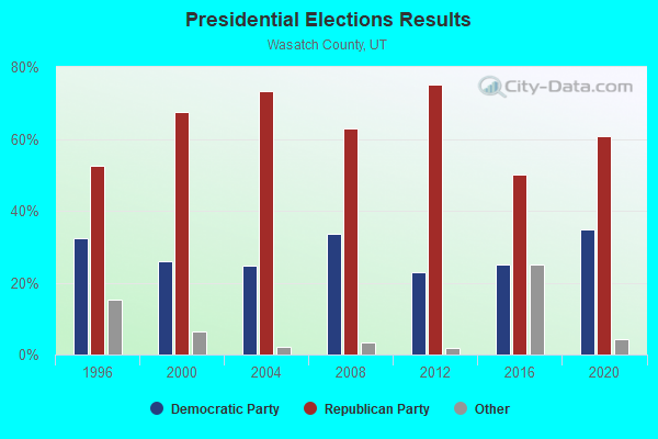
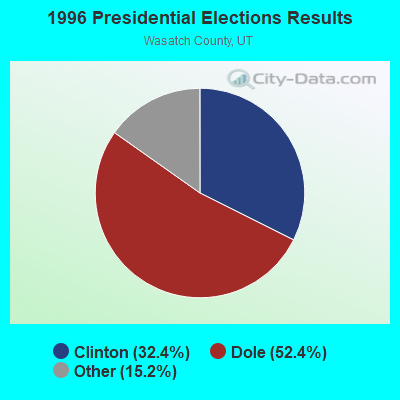
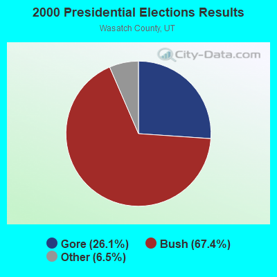
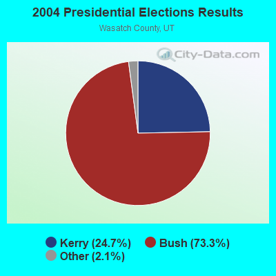
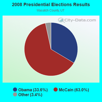
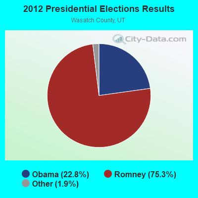
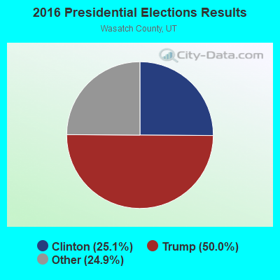
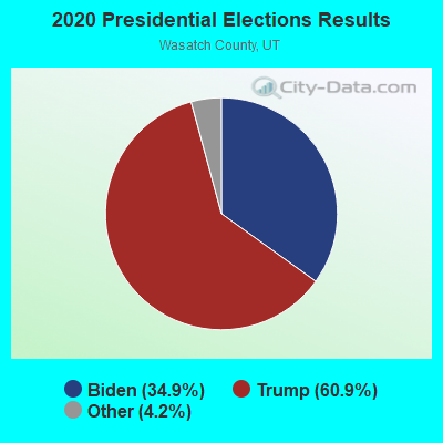
Graphs represent county-level data. Detailed 2008 Election Results
Religion statistics for Soldier Summit, UT (based on Wasatch County data)
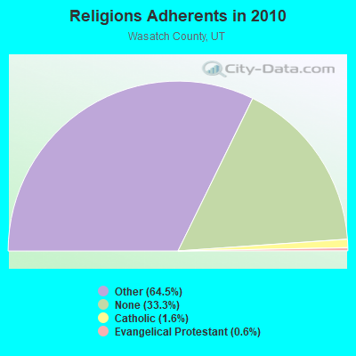
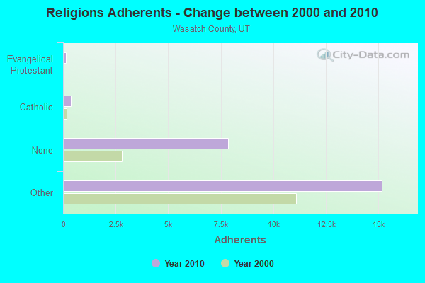
| Religion | Adherents | Congregations |
|---|---|---|
| Other | 15,174 | 40 |
| Catholic | 368 | 1 |
| Evangelical Protestant | 150 | 4 |
| None | 7,838 | - |
Food Environment Statistics:
| Here: | 1.96 / 10,000 pop. |
| State: | 1.37 / 10,000 pop. |
| This county: | 0.98 / 10,000 pop. |
| Utah: | 0.41 / 10,000 pop. |
| Here: | 2.94 / 10,000 pop. |
| State: | 2.82 / 10,000 pop. |
| Here: | 6.36 / 10,000 pop. |
| Utah: | 5.09 / 10,000 pop. |
| Wasatch County: | 4.9% |
| Utah: | 6.3% |
| Wasatch County: | 20.0% |
| Utah: | 23.6% |
Strongest AM radio stations in Soldier Summit:
- KOAL (750 AM; 10 kW; PRICE, UT; Owner: EASTERN UTAH BROADCASTING CO.)
- KALL (700 AM; 50 kW; NORTH SALT LAKE CITY, UT; Owner: CITICASTERS LICENSES, L.P.)
- KSLL (1080 AM; daytime; 10 kW; PRICE, UT; Owner: AGAINST THE WIND BROADCASTING, INC.)
- KIQN (1010 AM; 50 kW; TOOELE, UT)
- KSL (1160 AM; 50 kW; SALT LAKE CITY, UT; Owner: BONNEVILLE HOLDING COMPANY)
- KMTI (650 AM; 10 kW; MANTI, UT; Owner: SANPETE COUNTY BROADCASTING COMPANY)
- KOVO (960 AM; 5 kW; PROVO, UT; Owner: MILLCREEK BROADCASTING LLC)
- KTKK (630 AM; 10 kW; SANDY, UT; Owner: UNITED BROADCASTING COMPANY)
- KBEE (860 AM; 10 kW; SALT LAKE CITY, UT; Owner: CITADEL BROADCASTING COMPANY)
- KKDS (1060 AM; 10 kW; SOUTH SALT LAKE, UT; Owner: HOLIDAY BROADCASTING COMPANY)
- KNZZ (1100 AM; 50 kW; GRAND JUNCTION, CO; Owner: M B C GRAND BROADCASTING, INC.)
- KLLB (1510 AM; daytime; 10 kW; WEST JORDAN, UT; Owner: UNITED SECURITY FINANCIAL, INC.)
- KNRS (570 AM; 5 kW; SALT LAKE CITY, UT; Owner: CITICASTERS LICENSES, L.P.)
Strongest FM radio stations in Soldier Summit:
- K208AQ (89.5 FM; PRICE, UT; Owner: UNIVERSITY OF UTAH)
- KMXU (105.1 FM; MANTI, UT; Owner: MILLCREEK BROADCASTING, LLC)
- K288AN (105.5 FM; PRICE, UT; Owner: CARBON COUNTY)
- KQMB (102.7 FM; MIDVALE, UT; Owner: SIMMONS-SLC, LS, LLC)
- KXRK (96.3 FM; PROVO, UT; Owner: SIMMONS-SLC, LS, LLC)
- KTCE (92.3 FM; PAYSON, UT; Owner: MOENKOPI COMMUNICATIONS, INC.)
- K264AC (100.7 FM; RURAL UTAH COUNTY, UT; Owner: SIMMONS-SLC, LS, LLC)
- KENZ (107.5 FM; OREM, UT; Owner: CITADEL BROADCASTING COMPANY)
- K208BZ (89.5 FM; SPANISH FORK, UT; Owner: BRIGHAM YOUNG UNIVERSITY)
- KZHT (94.9 FM; PROVO, UT; Owner: CITICASTERS LICENSES, L.P.)
- KLGL (97.5 FM; RICHFIELD, UT; Owner: SANPETE COUNTY BROADCASTING CO.)
- KCPX (105.7 FM; CENTERVILLE, UT; Owner: MERCURY BROADCASTING COMPANY, INC.)
- KSOP-FM (104.3 FM; SALT LAKE CITY, UT; Owner: KSOP, INC.)
- K272DP (102.3 FM; TOOELE, UT; Owner: FAMILY STATIONS, INC.)
- KRCL (90.9 FM; SALT LAKE CITY, UT; Owner: LISTENERS COMMUNITY RADIO OF UTAH)
- KBZN (97.9 FM; OGDEN, UT; Owner: CAPITOL BROADCASTING, INC.)
- KOSY-FM (106.5 FM; SPANISH FORK, UT; Owner: MERCURY BROADCASTING COMPANY, INC.)
- KRSP-FM (103.5 FM; SALT LAKE CITY, UT; Owner: SIMMONS-SLC, LS, LLC)
- KBER (101.1 FM; OGDEN, UT; Owner: CITADEL BROADCASTING COMPANY)
- KISN-FM (97.1 FM; SALT LAKE CITY, UT; Owner: CLEAR CHANNEL BROADCASTING LICENSES, INC.)
TV broadcast stations around Soldier Summit:
- KUTF (Channel 3; PRICE, UT; Owner: PRICE BROADCASTING, INC.)
Soldier Summit fatal accident list:
Nov 5, 2004 02:50 AM, Sr-6, Vehicles: 2, Persons: 2, Fatalities: 1, Drunk persons involved: 1
Sep 15, 1985 04:45 AM, Sr6, Vehicles: 1, Persons: 1, Fatalities: 1, Drunk persons involved: 1
FCC Registered Microwave Towers:
1- CABIN RIDGE, Soldier Summit Sub Division Lot 32 (Lat: 39.900583 Lon: -111.120444), Type: Tower, Structure height: 48.7 m, Call Sign: WQKI878,
Assigned Frequencies: 932.418 MHz, 941.418 MHz, Grant Date: 05/23/2019, Expiration Date: 06/08/2029, Certifier: Brad G Zielie, Registrant: Prokarma, 222 So 15th St, Suite 505n, Omaha, NE 68102, Phone: (402) 522-5068, Fax: (402) 346-6676, Email:
Soldier Summit compared to Utah state average:
- Median household income significantly below state average.
- Median house value significantly below state average.
- Unemployed percentage significantly below state average.
- Black race population percentage significantly above state average.
- Hispanic race population percentage significantly below state average.
- Median age significantly below state average.
- Foreign-born population percentage significantly below state average.
- Renting percentage significantly below state average.
- Length of stay since moving in significantly above state average.
- Number of rooms per house significantly below state average.
- House age significantly below state average.
- Number of college students significantly below state average.
- Percentage of population with a bachelor's degree or higher significantly below state average.