Shopville, Kentucky
Submit your own pictures of this place and show them to the world
- OSM Map
- General Map
- Google Map
- MSN Map

| Males: 1,315 | |
| Females: 1,229 |
| Median resident age: | 37.2 years |
| Kentucky median age: | 35.9 years |
Zip code: 42501
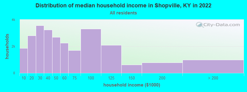
| Shopville: | $41,915 |
| KY: | $59,341 |
Estimated per capita income in 2022: $23,144 (it was $13,254 in 2000)
Shopville CCD income, earnings, and wages data
Estimated median house or condo value in 2022: $147,702 (it was $60,500 in 2000)
| Shopville: | $147,702 |
| KY: | $196,300 |
Mean prices in 2022: all housing units: $212,653; detached houses: $237,700; townhouses or other attached units: $213,978; in 2-unit structures: $221,046; in 3-to-4-unit structures: $201,942; mobile homes: $55,662
Detailed information about poverty and poor residents in Shopville, KY


- 2,34097.9%White alone
- 281.2%Hispanic
- 140.6%Two or more races
- 70.3%American Indian alone
- 10.04%Black alone
- 10.04%Asian alone

Races in Shopville detailed stats: ancestries, foreign born residents, place of birth
 Recent articles from our blog. Our writers, many of them Ph.D. graduates or candidates, create easy-to-read articles on a wide variety of topics.
Current Local Time: EST time zone
Elevation: 879 feet
Land area: 107.6 square miles.
Population density: 24 people per square mile (very low).

| Shopville CCD: | 0.6% ($368) |
| Kentucky: | 0.8% ($610) |
Nearest city with pop. 50,000+: Fayette, KY  (60.4 miles , pop. 260,512).
Nearest city with pop. 1,000,000+: Chicago, IL (367.8 miles , pop. 2,896,016).
Nearest cities:
), ), ), )Latitude: 37.16 N, Longitude: 84.41 W
Area code: 606

| Here: | 4.7% |
| Kentucky: | 3.8% |

- Health care (10.3%)
- Construction (8.8%)
- Agriculture, forestry, fishing & hunting (6.2%)
- Wood products (5.3%)
- Transportation equipment (5.1%)
- Groceries & related products merchant wholesalers (4.5%)
- Social assistance (4.5%)

- Construction (15.0%)
- Agriculture, forestry, fishing & hunting (8.4%)
- Wood products (7.1%)
- Groceries & related products merchant wholesalers (6.5%)
- Transportation equipment (6.4%)
- Truck transportation (5.9%)
- Department & other general merchandise stores (5.9%)

- Health care (23.7%)
- Social assistance (9.4%)
- Food & beverage stores (6.4%)
- Apparel, fabrics, notions merchant wholesalers (4.0%)
- Finance & insurance (4.0%)
- Professional, scientific, technical services (4.0%)
- Computer & electronic products (3.2%)

- Driver/sales workers and truck drivers (6.0%)
- Metal workers and plastic workers (5.3%)
- Other production occupations, including supervisors (4.4%)
- Other office and administrative support workers, including supervisors (4.3%)
- Electrical equipment mechanics and other installation, maintenance, and repair workers, including supervisors (4.2%)
- Textile, apparel, and furnishings workers (4.1%)
- Other sales and related occupations, including supervisors (4.1%)

- Driver/sales workers and truck drivers (10.2%)
- Metal workers and plastic workers (7.6%)
- Vehicle and mobile equipment mechanics, installers, and repairers (6.4%)
- Electrical equipment mechanics and other installation, maintenance, and repair workers, including supervisors (6.4%)
- Building and grounds cleaning and maintenance occupations (4.8%)
- Agricultural workers, including supervisors (4.8%)
- Electricians (4.8%)

- Textile, apparel, and furnishings workers (9.9%)
- Other office and administrative support workers, including supervisors (8.9%)
- Nursing, psychiatric, and home health aides (8.4%)
- Other production occupations, including supervisors (6.7%)
- Secretaries and administrative assistants (6.2%)
- Health technologists and technicians (5.2%)
- Cooks and food preparation workers (4.7%)
Average climate in Shopville, Kentucky
Based on data reported by over 4,000 weather stations


(lower is better)

Air Quality Index (AQI) level in 2022 was 62.9. This is about average.
| City: | 62.9 |
| U.S.: | 72.6 |

Ozone [ppb] level in 2022 was 28.6. This is about average. Closest monitor was 4.0 miles away from the city center.
| City: | 28.6 |
| U.S.: | 33.3 |

Particulate Matter (PM2.5) [µg/m3] level in 2022 was 7.87. This is about average. Closest monitor was 11.9 miles away from the city center.
| City: | 7.87 |
| U.S.: | 8.11 |
Tornado activity:
Shopville-area historical tornado activity is slightly below Kentucky state average. It is 4% greater than the overall U.S. average.
On 4/27/1971, a category F4 (max. wind speeds 207-260 mph) tornado 24.0 miles away from the Shopville place center killed 2 people and injured 72 people and caused between $500,000 and $5,000,000 in damages.
On 4/3/1974, a category F4 tornado 25.4 miles away from the place center killed 10 people and injured 113 people and caused between $5000 and $50,000 in damages.
Earthquake activity:
Shopville-area historical earthquake activity is significantly above Kentucky state average. It is 83% greater than the overall U.S. average.On 7/27/1980 at 18:52:21, a magnitude 5.2 (5.1 MB, 4.7 MS, 5.0 UK, 5.2 UK, Class: Moderate, Intensity: VI - VII) earthquake occurred 76.7 miles away from Shopville center
On 4/18/2008 at 09:36:59, a magnitude 5.4 (5.1 MB, 4.8 MS, 5.4 MW, 5.2 MW) earthquake occurred 209.9 miles away from Shopville center
On 9/7/1988 at 02:28:09, a magnitude 4.6 (4.5 MB, 4.6 LG, Class: Light, Intensity: IV - V) earthquake occurred 74.0 miles away from the city center
On 11/30/1973 at 07:48:41, a magnitude 4.7 (4.7 MB, 4.6 ML) earthquake occurred 97.3 miles away from the city center
On 8/9/2020 at 12:07:37, a magnitude 5.1 (5.1 MW, Depth: 4.7 mi) earthquake occurred 189.6 miles away from Shopville center
On 4/18/2008 at 09:36:59, a magnitude 5.2 (5.2 MW, Depth: 8.9 mi) earthquake occurred 209.9 miles away from Shopville center
Magnitude types: regional Lg-wave magnitude (LG), body-wave magnitude (MB), local magnitude (ML), surface-wave magnitude (MS), moment magnitude (MW)
Natural disasters:
The number of natural disasters in Pulaski County (14) is near the US average (15).Major Disasters (Presidential) Declared: 11
Emergencies Declared: 2
Causes of natural disasters: Tornadoes: 7, Storms: 6, Floods: 5, Mudslides: 2, Winter Storms: 2, Blizzard: 1, Freeze: 1, Hurricane: 1, Snow: 1, Snowfall: 1, Wind: 1, Other: 1 (Note: some incidents may be assigned to more than one category).
Hospitals and medical centers near Shopville:
- CUMBERLAND NURSING AND REHABILITATION CENTER (Nursing Home, about 12 miles away; SOMERSET, KY)
- INTREPID USA HEALTHCARE SERVICES (Home Health Center, about 13 miles away; SOMERSET, KY)
- SOMERSET NURSING AND REHABILITATION FACILITY (Nursing Home, about 13 miles away; SOMERSET, KY)
- HOSPICE OF LAKE CUMBERLAND (Hospital, about 15 miles away; SOMERSET, KY)
- OAKWOOD COMMUNITY CENTER (Hospital, about 15 miles away; SOMERSET, KY)
- LIFELINE ROCKCASTLE HOME HEALTH (Home Health Center, about 15 miles away; MOUNT VERNON, KY)
- PROFESSIONAL HOME HEALTH CARE, INC (Home Health Center, about 15 miles away; LONDON, KY)
Colleges/universities with over 2000 students nearest to Shopville:
- Somerset Community College (about 14 miles; Somerset, KY; Full-time enrollment: 4,698)
- University of the Cumberlands (about 33 miles; Williamsburg, KY; FT enrollment: 3,585)
- Eastern Kentucky University (about 41 miles; Richmond, KY; FT enrollment: 13,525)
- Lindsey Wilson College (about 50 miles; Columbia, KY; FT enrollment: 2,552)
- Campbellsville University (about 54 miles; Campbellsville, KY; FT enrollment: 2,948)
- Lincoln Memorial University (about 58 miles; Harrogate, TN; FT enrollment: 3,706)
- Bluegrass Community and Technical College (about 61 miles; Lexington, KY; FT enrollment: 8,560)
Points of interest:
Notable locations in Shopville: Public (A), Shopville - Stab Fire Department (B). Display/hide their locations on the map
Churches in Shopville include: Clifty Grove Baptist Church (A), Cedar Gap Church (B), Bethany Church (C), Acorn Church (D), Mount Pleasant Church (E), New Hope Church (F), Sunnyside Church (G), Rocklick Church (H), Pleasant Run Baptist Church (I). Display/hide their locations on the map
Cemeteries: Pleasant Run Cemetery (1), Pine Thicket Cemetery (2), Heron Cemetery (3), Childress Cemetery (4), Rock Lick Baptist Church Cemetery (5), Flat Lick Church Cemetery (6), Gilmore Cemetery (7). Display/hide their locations on the map
Streams, rivers, and creeks: Cedar Creek (A), Dry Fork (B), Dyer Branch (C), Elkhorn Branch (D), Emmil Branch (E), Green Branch (F), Langford Prong (G), Latham Branch (H), Laurel Fork (I). Display/hide their locations on the map
| This place: | 2.5 people |
| Kentucky: | 2.5 people |
| This place: | 72.6% |
| Whole state: | 66.9% |
| This place: | 4.4% |
| Whole state: | 6.4% |
Likely homosexual households (counted as self-reported same-sex unmarried-partner households)
- Lesbian couples: 0.0% of all households
- Gay men: 0.2% of all households
| This place: | 19.3% |
| Whole state: | 15.8% |
| This place: | 7.3% |
| Whole state: | 6.6% |
For population 15 years and over in Shopville:

- Never married: 17.3%
- Now married: 68.7%
- Separated: 1.5%
- Widowed: 5.5%
- Divorced: 8.6%
For population 25 years and over in Shopville:
- High school or higher: 58.1%
- Bachelor's degree or higher: 4.2%
- Graduate or professional degree: 1.1%
- Unemployed: 5.3%
- Mean travel time to work (commute): 26.6 minutes


| Here: | 15.2 |
| Kentucky average: | 13.8 |
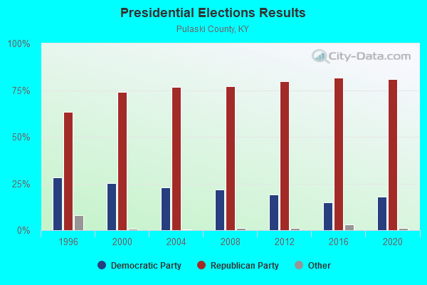
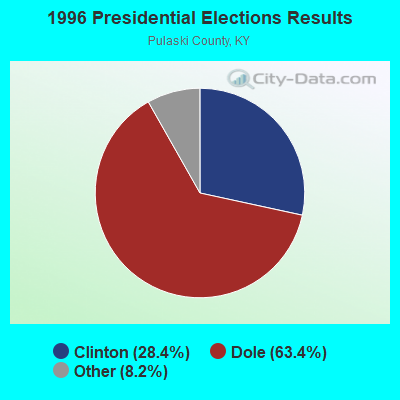
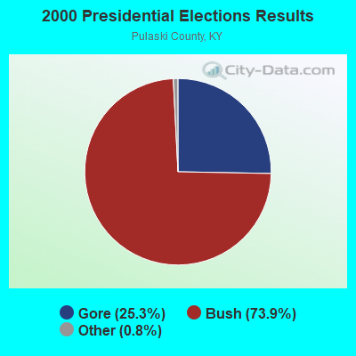
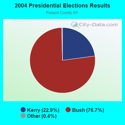
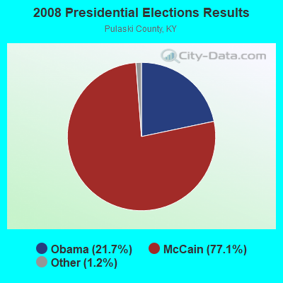
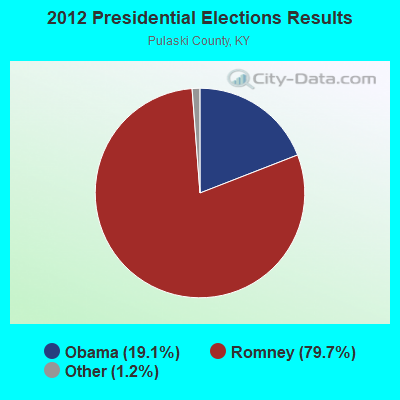
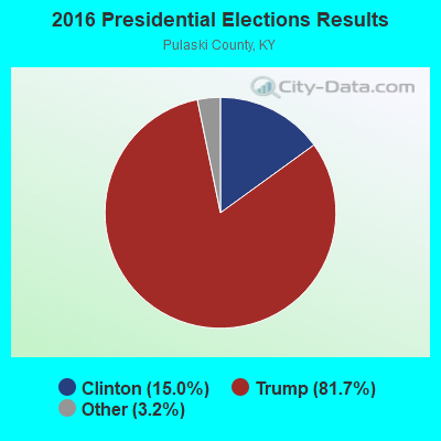
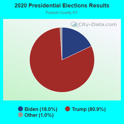
Graphs represent county-level data. Detailed 2008 Election Results
Religion statistics for Shopville, KY (based on Pulaski County data)
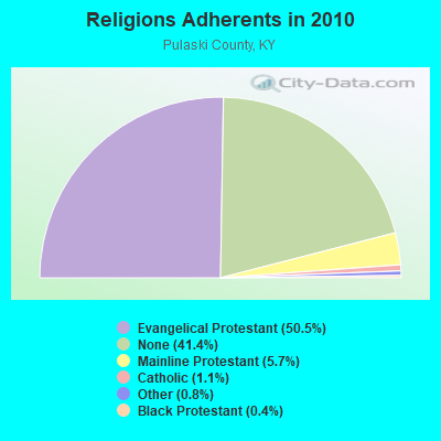
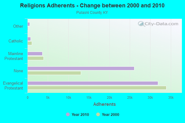
| Religion | Adherents | Congregations |
|---|---|---|
| Evangelical Protestant | 31,865 | 134 |
| Mainline Protestant | 3,589 | 24 |
| Catholic | 725 | 1 |
| Other | 534 | 3 |
| Black Protestant | 273 | 2 |
| None | 26,077 | - |
Food Environment Statistics:
| Here: | 2.83 / 10,000 pop. |
| Kentucky: | 2.19 / 10,000 pop. |
| Here: | 0.17 / 10,000 pop. |
| State: | 0.25 / 10,000 pop. |
| Here: | 0.67 / 10,000 pop. |
| State: | 0.74 / 10,000 pop. |
| Pulaski County: | 5.16 / 10,000 pop. |
| Kentucky: | 4.36 / 10,000 pop. |
| This county: | 3.83 / 10,000 pop. |
| Kentucky: | 5.74 / 10,000 pop. |
| Pulaski County: | 11.0% |
| Kentucky: | 11.0% |
| This county: | 29.8% |
| State: | 30.0% |
| Pulaski County: | 11.1% |
| Kentucky: | 15.9% |
Strongest AM radio stations in Shopville:
- WKVL (850 AM; daytime; 50 kW; KNOXVILLE, TN; Owner: HORNE RADIO, LLC)
- WKDP (1330 AM; 5 kW; CORBIN, KY; Owner: EUBANKS BROADCASTING, INC.)
- WHAS (840 AM; 50 kW; LOUISVILLE, KY; Owner: CLEAR CHANNEL BROADCASTING LICENSES, INC.)
- WEKC (710 AM; daytime; 4 kW; WILLIAMSBURG, KY; Owner: GERALD PARKS)
- WGWM (980 AM; 1 kW; LONDON, KY; Owner: WGWM BROADCASTING, INC.)
- WSFC (1240 AM; 1 kW; SOMERSET, KY; Owner: CAPSTAR TX LIMITED PARTNERSHIP)
- WTLO (1480 AM; 1 kW; SOMERSET, KY; Owner: CUMBERLAND COMMUNICATIONS, INC.)
- WKLB (1290 AM; 5 kW; MANCHESTER, KY; Owner: BARKER BROADCASTING COMPANY, INC.)
- WSM (650 AM; 50 kW; NASHVILLE, TN; Owner: GAYLORD ENTERTAINMENT COMPANY)
- WLW (700 AM; 50 kW; CINCINNATI, OH; Owner: JACOR BROADCASTING CORPORATION)
- WWAM (820 AM; daytime; 50 kW; JASPER, TN; Owner: SHELTON BROADCASTING SYSTEM)
- WKEQ (910 AM; 0 kW; BURNSIDE, KY; Owner: CAPSTAR TX LIMITED PARTNERSHIP)
- WTVN (610 AM; 50 kW; COLUMBUS, OH; Owner: CITICASTERS LICENSES, L.P.)
Strongest FM radio stations in Shopville:
- WLLK (93.9 FM; BURNSIDE, KY; Owner: CAPSTAR TX LIMITED PARTNERSHIP)
- WTHL (90.5 FM; SOMERSET, KY; Owner: SOMERSET EDUCATIONAL BROADCASTING FOUNDATION)
- WSEK (97.1 FM; SOMERSET, KY; Owner: CAPSTAR TX LIMITED PARTNERSHIP)
- WYGE (92.3 FM; LONDON, KY; Owner: ETHEL HUFF BROADCASTING, LLC)
- W277AA (103.3 FM; SOMERSET, KY; Owner: WESTERN KENTUCKY UNIVERSITY)
- WEKX (102.7 FM; JELLICO, TN; Owner: WHITLEY BROADCASTING CO., INC.)
- WKDP-FM (99.5 FM; CORBIN, KY; Owner: EUBANKS BROADCASTING, INC.)
- WKII-FM (102.3 FM; SOMERSET, KY; Owner: CAPSTAR TX LIMITED PARTNERSHIP)
- WLFX (106.7 FM; BEREA, KY; Owner: WALLINGFORD COMMUNICATIONS, LLC)
- WMIK-FM (92.7 FM; MIDDLESBORO, KY; Owner: GATEWAY BROADCASTING, INC.)
- WWEL (103.9 FM; LONDON, KY; Owner: F.T.G. BROADCASTING, INC.)
- WVCT (91.5 FM; KEAVY, KY; Owner: VICTORY TRAINING SCHOOL CORP.)
- WTBK (105.7 FM; MANCHESTER, KY; Owner: MANCHESTER COMMUNICATIONS, INC.)
- WEZJ-FM (104.3 FM; WILLIAMSBURG, KY; Owner: WHITLEY BROADCASTING CO., INC.)
- WCTT-FM (107.3 FM; CORBIN, KY; Owner: ENCORE COMMUNICATIONS, INC.)
- WXKY-FM (96.3 FM; STANFORD, KY; Owner: LINCOLN-GARRARD BROADCASTING CO.,INC)
- WMKZ (93.1 FM; MONTICELLO, KY; Owner: MONTICELLO-WAYNE COUNTY MEDIA, INC.)
- WCYO (100.7 FM; IRVINE, KY; Owner: KENTUCKY RIVER BROADCASTING CO.)
- WKYM (101.7 FM; MONTICELLO, KY; Owner: STEPHEN W. STAPLES JR.)
TV broadcast stations around Shopville:
- WKSO-TV (Channel 29; SOMERSET, KY; Owner: KENTUCKY AUTHORITY FOR EDUCATIONAL TV)
- WDKY-TV (Channel 56; DANVILLE, KY; Owner: WDKY LICENSEE, LLC)
- WOBZ-LP (Channel 9; EAST BERNSTADT, ETC., KY; Owner: ANDREA JOY KESLER)
- WVTN-LP (Channel 48; CORBIN, KY; Owner: VICTORY TRAINING SCHOOL CORP.)
- WBLU-LP (Channel 62; LEXINGTON, KY; Owner: SANDRA B. POWLEY)
- W39CK (Channel 20; CORBIN, KY; Owner: DEREK RAY EUBANKS)
FCC Registered Broadcast Land Mobile Towers:
1- Ekpc Substa Off Ky 461 2 Km N (Lat: 37.171750 Lon: -84.481611), Type: Tower, Structure height: 14 m, Overall height: 17 m, Call Sign: WPJJ889,
Assigned Frequencies: 456.100 MHz, Grant Date: 04/21/2011, Expiration Date: 07/02/2021, Cancellation Date: 11/08/2012, Certifier: Don Alexander, Registrant: Utc Service Corp, 1140 Connecticut Ave Nw Ste 1110, Washington, DC 20036, Phone: (202) 872-0030, Fax: (202) 331-7639
FCC Registered Microwave Towers:
1- KY SHP SRH, Lat: 37.140111 Lon: -84.534389, Type: Ltower, Structure height: 45 m, Overall height: 46 m, Call Sign: WQTX951,
Assigned Frequencies: 3650.00 MHz, Grant Date: 05/03/2014, Expiration Date: 05/03/2024, Certifier: Eric Wilson, Registrant: Ridgenet Network Group, LLC, 28 Wilson Loop Road, Science Hill, KY 42553, Phone: (606) 280-9815, Email:
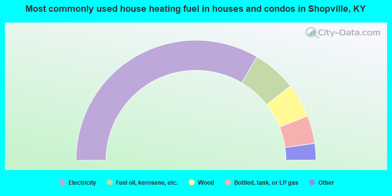
- 67.0%Electricity
- 11.8%Fuel oil, kerosene, etc.
- 9.2%Wood
- 7.5%Bottled, tank, or LP gas
- 3.0%Utility gas
- 1.5%Coal or coke
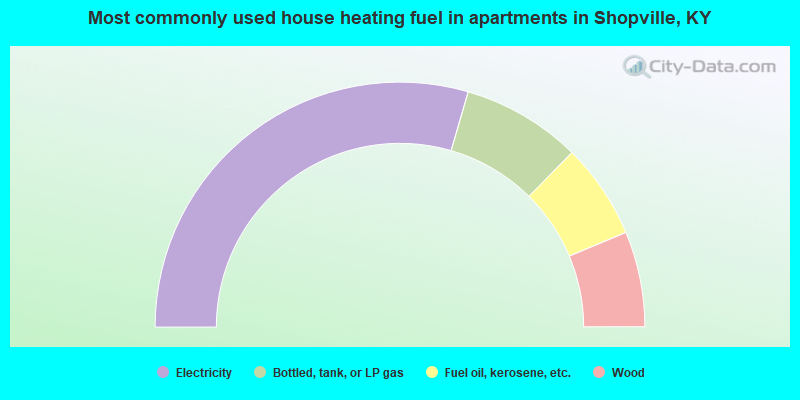
- 59.0%Electricity
- 15.8%Bottled, tank, or LP gas
- 12.6%Fuel oil, kerosene, etc.
- 12.6%Wood
Shopville compared to Kentucky state average:
- Unemployed percentage below state average.
- Black race population percentage significantly below state average.
- Hispanic race population percentage significantly below state average.
- Foreign-born population percentage significantly below state average.
- Renting percentage below state average.
- Length of stay since moving in significantly above state average.
- Number of rooms per house significantly below state average.
- House age significantly below state average.
- Percentage of population with a bachelor's degree or higher significantly below state average.