Shirley-Ismay, Montana
Submit your own pictures of this place and show them to the world
- OSM Map
- Google Map
- MSN Map
| Males: 159 | |
| Females: 148 |
| Median resident age: | 39.8 years |
| Montana median age: | 37.5 years |
Zip code: 59336
| Shirley-Ismay: | $60,572 |
| MT: | $67,631 |
Estimated per capita income in 2022: $28,956 (it was $13,029 in 2000)
Shirley-Ismay CCD income, earnings, and wages data
Estimated median house or condo value in 2022: $331,060 (it was $86,300 in 2000)
| Shirley-Ismay: | $331,060 |
| MT: | $366,400 |
Detailed information about poverty and poor residents in Shirley-Ismay, MT


- 31597.5%White alone
- 41.2%Two or more races
- 30.9%Hispanic
- 10.3%American Indian alone

Races in Shirley-Ismay detailed stats: ancestries, foreign born residents, place of birth
 Recent articles from our blog. Our writers, many of them Ph.D. graduates or candidates, create easy-to-read articles on a wide variety of topics.
Current Local Time: MST time zone
Land area: 925.6 square miles.
Population density: 0.3 people per square mile (very low).
| Shirley-Ismay CCD: | 1.7% ($1,438) |
| Montana: | 1.3% ($1,212) |
Nearest city with pop. 50,000+: Billings, MT  (166.1 miles , pop. 89,847).
Nearest city with pop. 200,000+: West Adams, CO (456.6 miles , pop. 259,628).
Nearest city with pop. 1,000,000+: Chicago, IL (925.0 miles , pop. 2,896,016).
Nearest cities:
), ), Latitude: 46.47 N, Longitude: 105.22 W
Area code commonly used in this area: 406

| Here: | 3.6% |
| Montana: | 3.8% |

- Agriculture, forestry, fishing & hunting (43.4%)
- Educational services (14.0%)
- Health care (7.7%)
- Professional, scientific, technical services (4.2%)
- Accommodation & food services (4.2%)
- Building material & garden equipment & supplies dealers (3.5%)
- Construction (2.8%)

- Agriculture, forestry, fishing & hunting (65.3%)
- Construction (5.3%)
- Truck transportation (5.3%)
- Farm product raw materials merchant wholesalers (4.0%)
- Building material & garden equipment & supplies dealers (4.0%)
- Other transportation, support activities, couriers (4.0%)
- Social assistance (4.0%)

- Educational services (29.4%)
- Agriculture, forestry, fishing & hunting (19.1%)
- Health care (16.2%)
- Accommodation & food services (8.8%)
- Professional, scientific, technical services (7.4%)
- Health & personal care, except drug, stores (4.4%)
- Personal & laundry services (4.4%)

- Farmers and farm managers (32.2%)
- Other teachers, instructors, education, training, and library occupations (7.7%)
- Top executives (6.3%)
- Other sales and related occupations, including supervisors (5.6%)
- Preschool, kindergarten, elementary, and middle school teachers (4.9%)
- Registered nurses (4.9%)
- Agricultural workers, including supervisors (4.9%)

- Farmers and farm managers (50.7%)
- Top executives (8.0%)
- Other sales and related occupations, including supervisors (8.0%)
- Driver/sales workers and truck drivers (8.0%)
- Agricultural workers, including supervisors (6.7%)
- Other management occupations, except farmers and farm managers (4.0%)
- Bus drivers (4.0%)

- Other teachers, instructors, education, training, and library occupations (16.2%)
- Farmers and farm managers (11.8%)
- Preschool, kindergarten, elementary, and middle school teachers (10.3%)
- Registered nurses (10.3%)
- Information and record clerks, except customer service representatives (4.4%)
- Personal appearance workers (4.4%)
- Waiters and waitresses (4.4%)
Average climate in Shirley-Ismay, Montana
Based on data reported by over 4,000 weather stations


Earthquake activity:
Shirley-Ismay-area historical earthquake activity is significantly above Montana state average. It is 285% greater than the overall U.S. average.On 8/18/1959 at 06:37:13, a magnitude 7.7 (7.7 UK, Class: Major, Intensity: VIII - XII) earthquake occurred 294.6 miles away from the city center, causing $26,000,000 total damage
On 10/28/1983 at 14:06:06, a magnitude 7.3 (6.2 MB, 7.3 MS, 7.0 MW) earthquake occurred 449.2 miles away from Shirley-Ismay center, causing 2 deaths (2 shaking deaths) and 3 injuries, causing $15,000,000 total damage
On 6/30/1975 at 18:54:13, a magnitude 6.1 (5.6 MB, 5.9 MS, 6.1 UK, 6.1 ML, Class: Strong, Intensity: VII - IX) earthquake occurred 294.8 miles away from the city center
On 9/8/1984 at 00:59:31, a magnitude 5.1 (5.1 MB, Class: Moderate, Intensity: VI - VII) earthquake occurred 159.1 miles away from the city center
On 5/29/1984 at 20:18:32, a magnitude 5.0 (5.0 MB) earthquake occurred 159.3 miles away from the city center
On 10/18/1984 at 15:30:23, a magnitude 5.5 (5.4 MB, 5.1 MS, 5.5 ML) earthquake occurred 282.7 miles away from Shirley-Ismay center
Magnitude types: body-wave magnitude (MB), local magnitude (ML), surface-wave magnitude (MS), moment magnitude (MW)
Natural disasters:
The number of natural disasters in Custer County (7) is smaller than the US average (15).Major Disasters (Presidential) Declared: 4
Emergencies Declared: 1
Causes of natural disasters: Floods: 3, Fire: 1, Hurricane: 1, Storm: 1, Winter Storm: 1, Other: 1 (Note: some incidents may be assigned to more than one category).
Colleges/universities with over 2000 students nearest to Shirley-Ismay:
- Sheridan College (about 145 miles; Sheridan, WY; Full-time enrollment: 2,070)
- Black Hills State University (about 152 miles; Spearfish, SD; FT enrollment: 3,166)
- Montana State University-Billings (about 166 miles; Billings, MT; FT enrollment: 4,319)
- South Dakota School of Mines and Technology (about 193 miles; Rapid City, SD; FT enrollment: 2,102)
- Bismarck State College (about 211 miles; Bismarck, ND; FT enrollment: 3,015)
- University of Mary (about 213 miles; Bismarck, ND; FT enrollment: 2,854)
- Minot State University (about 221 miles; Minot, ND; FT enrollment: 2,887)
Points of interest:
Notable locations in Shirley-Ismay: Bradshaw Ranch (A), Campbell Ranch (B), Locate Rest Area (C), Ismay Grain Company Elevator (D), Ismay (E), Shirley (F), Tusler (G), Gilman Ranch (H), Bonfield Fishing Access Site (I), Locate (J), Ismay Rural Volunteer Fire Company (K). Display/hide their locations on the map
Cemeteries: Cottonwood Cemetery (1), Ismay Cemetery (2), Knowlton Cemetery (3). Display/hide their locations on the map
Reservoirs: Shoemaker (A), Tepee Butte Reservoir (B), Dead Cow Reservoir (C), McFarland Reservoir (D). Display/hide their locations on the map
Creeks: Malone Creek (A), Station Creek (B), Lumpjaw Creek (C), Alice Creek (D), Alkali Creek (E), Archdale Creek (F), Bert Creek (G), Big Tepee Creek (H), Blacktail Creek (I). Display/hide their locations on the map
Parks in Shirley-Ismay include: After the Roundup Historical Marker (1), Powder River Historical Marker (2), George Park (3). Display/hide their locations on the map
| This place: | 2.2 people |
| Montana: | 2.4 people |
| This place: | 72.0% |
| Whole state: | 62.8% |
| This place: | 3.2% |
| Whole state: | 6.7% |
Likely homosexual households (counted as self-reported same-sex unmarried-partner households)
- Lesbian couples: 1.6% of all households
- Gay men: 0.0% of all households
| This place: | 17.2% |
| Whole state: | 14.6% |
| This place: | 3.4% |
| Whole state: | 5.8% |
For population 15 years and over in Shirley-Ismay:

- Never married: 18.7%
- Now married: 74.7%
- Separated: 0.8%
- Widowed: 3.3%
- Divorced: 3.3%
For population 25 years and over in Shirley-Ismay:
- High school or higher: 83.4%
- Bachelor's degree or higher: 24.4%
- Graduate or professional degree: 4.9%
- Unemployed: 9.5%
- Mean travel time to work (commute): 12.8 minutes


| Here: | 11.4 |
| Montana average: | 10.4 |
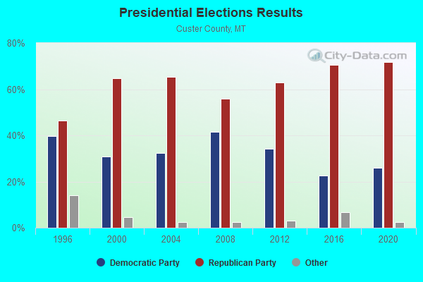
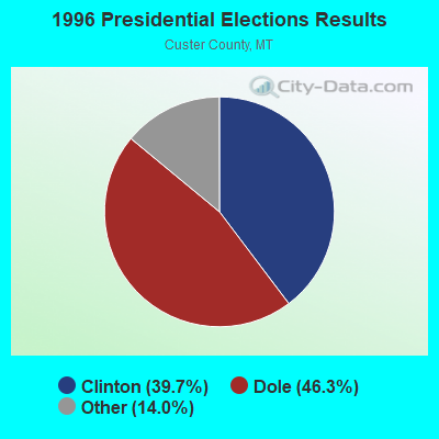


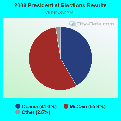
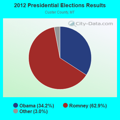
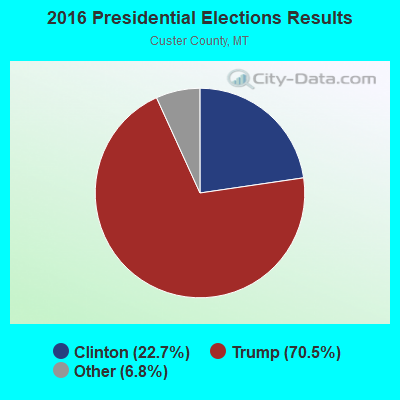
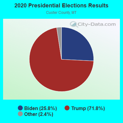
Graphs represent county-level data. Detailed 2008 Election Results
Religion statistics for Shirley-Ismay, MT (based on Custer County data)
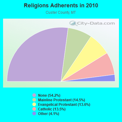
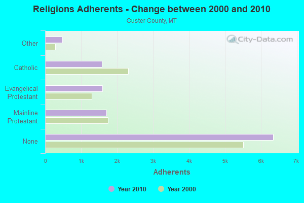
| Religion | Adherents | Congregations |
|---|---|---|
| Mainline Protestant | 1,699 | 7 |
| Evangelical Protestant | 1,594 | 9 |
| Catholic | 1,580 | 1 |
| Other | 483 | 1 |
| None | 6,343 | - |
Food Environment Statistics:
| Custer County: | 1.79 / 10,000 pop. |
| Montana: | 2.55 / 10,000 pop. |
| This county: | 8.06 / 10,000 pop. |
| State: | 4.69 / 10,000 pop. |
| This county: | 8.96 / 10,000 pop. |
| State: | 10.38 / 10,000 pop. |
| Custer County: | 8.3% |
| State: | 7.2% |
| This county: | 25.8% |
| Montana: | 23.1% |
| Here: | 15.3% |
| Montana: | 10.7% |
Strongest AM radio stations in Shirley-Ismay:
- KATL (770 AM; 10 kW; MILES CITY, MT; Owner: STAR PRINTING COMPANY)
- KMTA (1050 AM; 10 kW; MILES CITY, MT; Owner: SENGER BROADCASTING CORPORATION)
- KFLN (960 AM; 5 kW; BAKER, MT; Owner: NEWELL BROADCASTING INC.)
- KXMR (710 AM; 50 kW; BISMARCK, ND; Owner: RADIO BISMARCK MANDAN, LLC)
- KBHB (810 AM; 25 kW; STURGIS, SD; Owner: MONTEREY LICENSES, LLC)
- KIKC (1250 AM; 5 kW; FORSYTH, MT; Owner: MILES CITY, FORSYTH B/DCSTG, INC.)
- KTWO (1030 AM; 50 kW; CASPER, WY; Owner: CITICASTERS LICENSES, L.P.)
- KGLE (590 AM; 1 kW; GLENDIVE, MT; Owner: FRIENDS OF CHRISTIAN RADIO, INC.)
- KUYO (830 AM; daytime; 25 kW; EVANSVILLE, WY; Owner: WYOMING CHRISTIAN BROADCASTING COMPANY)
- KEYZ (660 AM; 5 kW; WILLISTON, ND; Owner: COMMONWEALTH LICENSE SUBSIDIARY, LLC)
- KERR (750 AM; 50 kW; POLSON, MT; Owner: ANDERSON RADIO BROADCASTING, INC.)
- KLTT (670 AM; 50 kW; COMMERCE CITY, CO; Owner: KLZ RADIO, INC.)
- KKZN (760 AM; 50 kW; THORNTON, CO; Owner: JACOR BROADCASTING OF COLORADO, INC.)
Strongest FM radio stations in Shirley-Ismay:
- KKRY (92.5 FM; MILES CITY, MT; Owner: SENGER BROADCASTING CORPORATION)
- KECC (90.7 FM; MILES CITY, MT; Owner: MONTANA STATE UNIVERSITY -BILLINGS)

- 72.3%Bottled, tank, or LP gas
- 10.8%Electricity
- 9.6%Wood
- 4.8%Utility gas
- 2.4%Coal or coke

- 40.0%Bottled, tank, or LP gas
- 30.0%Utility gas
- 15.0%Coal or coke
- 15.0%Wood
Shirley-Ismay compared to Montana state average:
- Black race population percentage significantly below state average.
- Hispanic race population percentage significantly below state average.
- Foreign-born population percentage significantly below state average.
- Length of stay since moving in significantly above state average.
- Number of rooms per house significantly below state average.
- House age significantly below state average.
- Number of college students below state average.