Shady Valley, Tennessee
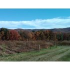
Shady Valley: view from my sisters house this past fall
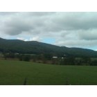
Shady Valley: just a random picture in shady valley
- add
your
Submit your own pictures of this place and show them to the world
- OSM Map
- General Map
- Google Map
- MSN Map

| Males: 568 | |
| Females: 590 |
| Median resident age: | 45.6 years |
| Tennessee median age: | 35.9 years |
Zip code: 37688
| Shady Valley: | $47,619 |
| TN: | $65,254 |
Estimated per capita income in 2022: $25,896 (it was $12,785 in 2000)
Shady Valley CCD income, earnings, and wages data
Estimated median house or condo value in 2022: $219,462 (it was $70,100 in 2000)
| Shady Valley: | $219,462 |
| TN: | $284,800 |
Mean prices in 2022: all housing units: $241,483; detached houses: $274,541; townhouses or other attached units: $93,361; mobile homes: $108,127
Detailed information about poverty and poor residents in Shady Valley, TN


- 1,09997.9%White alone
- 100.9%Hispanic
- 50.4%American Indian alone
- 50.4%Other race alone
- 20.2%Black alone
- 10.09%Asian alone
- 10.09%Two or more races

Races in Shady Valley detailed stats: ancestries, foreign born residents, place of birth
According to our research of Tennessee and other state lists, there were 2 registered sex offenders living in Shady Valley, Tennessee as of May 23, 2024.
The ratio of all residents to sex offenders in Shady Valley is 579 to 1.
The ratio of registered sex offenders to all residents in this city is lower than the state average.
 Recent articles from our blog. Our writers, many of them Ph.D. graduates or candidates, create easy-to-read articles on a wide variety of topics.
Current Local Time: EST time zone
Elevation: 2790 feet
Land area: 54.2 square miles.
Population density: 21 people per square mile (very low).

| Shady Valley CCD: | 0.6% ($435) |
| Tennessee: | 0.8% ($715) |
Nearest city with pop. 50,000+: Johnson City, TN  (28.7 miles , pop. 55,469).
Nearest city with pop. 200,000+: Charlotte, NC (109.9 miles , pop. 540,828).
Nearest city with pop. 1,000,000+: Philadelphia, PA (438.9 miles , pop. 1,517,550).
Nearest cities:
), ), ), Latitude: 36.53 N, Longitude: 81.92 W
Area code: 423


| Here: | 3.0% |
| Tennessee: | 3.0% |

- Health care (12.6%)
- Educational services (6.9%)
- Textile mills & textile products (6.3%)
- Administrative & support & waste management services (5.7%)
- Accommodation & food services (5.7%)
- Construction (5.5%)
- Agriculture, forestry, fishing & hunting (4.9%)

- Accommodation & food services (11.1%)
- Agriculture, forestry, fishing & hunting (9.4%)
- Department & other general merchandise stores (8.3%)
- Construction (7.8%)
- Textile mills & textile products (7.8%)
- Wood products (7.2%)
- Machinery (6.1%)

- Health care (22.0%)
- Educational services (14.3%)
- Administrative & support & waste management services (11.9%)
- Food & beverage stores (7.7%)
- Public administration (5.4%)
- Textile mills & textile products (4.8%)
- Professional & commercial equipment & supplies merchant wholesalers (4.2%)

- Building and grounds cleaning and maintenance occupations (9.8%)
- Secretaries and administrative assistants (9.8%)
- Textile, apparel, and furnishings workers (5.7%)
- Preschool, kindergarten, elementary, and middle school teachers (5.5%)
- Woodworkers (5.5%)
- Other production occupations, including supervisors (5.5%)
- Information and record clerks, except customer service representatives (4.9%)

- Woodworkers (10.6%)
- Building and grounds cleaning and maintenance occupations (9.4%)
- Agricultural workers, including supervisors (6.7%)
- Other production occupations, including supervisors (6.7%)
- Other teachers, instructors, education, training, and library occupations (5.6%)
- Material recording, scheduling, dispatching, and distributing workers (5.6%)
- Cooks and food preparation workers (5.0%)

- Secretaries and administrative assistants (16.1%)
- Preschool, kindergarten, elementary, and middle school teachers (11.3%)
- Building and grounds cleaning and maintenance occupations (10.1%)
- Health technologists and technicians (8.9%)
- Cashiers (7.7%)
- Textile, apparel, and furnishings workers (7.1%)
- Information and record clerks, except customer service representatives (6.5%)
Average climate in Shady Valley, Tennessee
Based on data reported by over 4,000 weather stations


(lower is better)

Lead (Pb) [µg/m3] level in 2008 was 0.0520. This is significantly worse than average. Closest monitor was 14.2 miles away from the city center.
| City: | 0.0520 |
| U.S.: | 0.0093 |
Tornado activity:
Shady Valley-area historical tornado activity is significantly below Tennessee state average. It is 70% smaller than the overall U.S. average.
On 4/4/1974, a category F3 (max. wind speeds 158-206 mph) tornado 22.1 miles away from the Shady Valley place center killed one person and injured 4 people and caused between $50,000 and $500,000 in damages.
On 7/10/1980, a category F3 tornado 33.0 miles away from the place center injured 12 people and caused between $50,000 and $500,000 in damages.
Earthquake activity:
Shady Valley-area historical earthquake activity is significantly above Tennessee state average. It is 12% greater than the overall U.S. average.On 8/9/2020 at 12:07:37, a magnitude 5.1 (5.1 MW, Depth: 4.7 mi, Class: Moderate, Intensity: VI - VII) earthquake occurred 45.9 miles away from Shady Valley center
On 8/23/2011 at 17:51:04, a magnitude 5.8 (5.8 MW, Depth: 3.7 mi) earthquake occurred 239.1 miles away from Shady Valley center
On 7/27/1980 at 18:52:21, a magnitude 5.2 (5.1 MB, 4.7 MS, 5.0 UK, 5.2 UK) earthquake occurred 160.7 miles away from the city center
On 11/30/1973 at 07:48:41, a magnitude 4.7 (4.7 MB, 4.6 ML, Class: Light, Intensity: IV - V) earthquake occurred 124.9 miles away from the city center
On 11/23/2006 at 10:42:57, a magnitude 4.3 (4.3 MB) earthquake occurred 43.5 miles away from Shady Valley center
On 11/2/2006 at 17:53:02, a magnitude 4.3 (4.3 MB, Depth: 0.6 mi) earthquake occurred 46.4 miles away from Shady Valley center
Magnitude types: body-wave magnitude (MB), local magnitude (ML), surface-wave magnitude (MS), moment magnitude (MW)
Natural disasters:
The number of natural disasters in Johnson County (13) is near the US average (15).Major Disasters (Presidential) Declared: 9
Emergencies Declared: 2
Causes of natural disasters: Floods: 8, Storms: 7, Heavy Rains: 2, Tornadoes: 2, Flash Flood: 1, Hurricane: 1, Landslide: 1, Mudslide: 1, Snowfall: 1, Wind: 1, Winter Storm: 1, Other: 1 (Note: some incidents may be assigned to more than one category).
Hospitals and medical centers near Shady Valley:
- FMC MOUNTAIN CITY (Dialysis Facility, about 8 miles away; MOUNTAIN CITY, TN)
- JOHNSON CO HOME HEALTH (Home Health Center, about 9 miles away; MOUNTAIN CITY, TN)
- (CLOSED) JOHNSON COUNTY HEALTH CENTER (Hospital, about 9 miles away; MOUNTAIN CITY, TN)
- JOHNSON COUNTY COMMUNITY HOSPITAL Critical Access Hospitals (about 9 miles away; MOUNTAIN CITY, TN)
- WELLMONT HOSPICE (Hospital, about 13 miles away; ABINGDON, VA)
- JOHNSTON MEMORIAL HOME CARE (Home Health Center, about 13 miles away; ABINGDON, VA)
- INTREPID USA HEALTHCARE SERVICES (Home Health Center, about 14 miles away; ABINGDON, VA)
Colleges/universities with over 2000 students nearest to Shady Valley:
- King University (about 14 miles; Bristol, TN; Full-time enrollment: 2,472)
- Appalachian State University (about 26 miles; Boone, NC; FT enrollment: 17,362)
- Northeast State Community College (about 28 miles; Blountville, TN; FT enrollment: 4,480)
- East Tennessee State University (about 30 miles; Johnson City, TN; FT enrollment: 12,774)
- Wilkes Community College (about 50 miles; Wilkesboro, NC; FT enrollment: 2,292)
- Caldwell Community College and Technical Institute (about 53 miles; Hudson, NC; FT enrollment: 3,636)
- Tusculum College (about 54 miles; Greeneville, TN; FT enrollment: 2,070)
Public elementary/middle school in Shady Valley:
- SHADY VALLEY ELEMENTARY (Students: 69, Location: 423 HWY 133, Grades: PK-6)
Points of interest:
Notable locations in Shady Valley: Abingdon Gap Appalachian Trail Shelter (A), Shady Valley Volunteer Fire Department (B). Display/hide their locations on the map
Churches in Shady Valley include: Rock Church (A), Shady Valley Church (B). Display/hide their locations on the map
Cemeteries: Scott Cemetery (1), Wood Cemetery (2), Blevins Cemetery (3), Heaberlin Cemetery (4), Blevins Cemetery (5), Scott Cemetery (6), Cole Cemetery (7). Display/hide their locations on the map
Streams, rivers, and creeks: Low Gap Branch (A), Locust Knob Branch (B), Stillhouse Branch (C), Backbone Branch (D), Jim Wright Branch (E), Buck Ridge Branch (F), Chalk Branch (G), Fagall Branch (H), Maple Branch (I). Display/hide their locations on the map
Park in Shady Valley: Backbone Rock Recreation Area (1). Display/hide its location on the map
Drinking water stations with addresses in Shady Valley and their reported violations in the past:
SHADY VALLEY COUNTRY STORE (Population served: 25, Groundwater):Past monitoring violations:
- Monitoring, Source Water (GWR) - In APR-01-2014, Contaminant: E. COLI. Follow-up actions: St Violation/Reminder Notice (MAY-01-2014), St Public Notif requested (MAY-01-2014)
- Monitoring, Repeat Major (TCR) - In MAR-2014, Contaminant: Coliform (TCR). Follow-up actions: St Violation/Reminder Notice (MAY-01-2014), St Public Notif requested (MAY-01-2014)
- One routine major monitoring violation
| This place: | 2.4 people |
| Tennessee: | 2.5 people |
| This place: | 64.8% |
| Whole state: | 69.8% |
| This place: | 3.6% |
| Whole state: | 4.2% |
Likely homosexual households (counted as self-reported same-sex unmarried-partner households)
- Lesbian couples: 0.2% of all households
- Gay men: 0.4% of all households
| This place: | 15.2% |
| Whole state: | 13.5% |
| This place: | 7.6% |
| Whole state: | 5.8% |
For population 15 years and over in Shady Valley:

- Never married: 15.8%
- Now married: 63.5%
- Separated: 0.5%
- Widowed: 10.2%
- Divorced: 10.5%
For population 25 years and over in Shady Valley:
- High school or higher: 60.4%
- Bachelor's degree or higher: 7.0%
- Graduate or professional degree: 2.3%
- Unemployed: 5.9%
- Mean travel time to work (commute): 31.3 minutes


| Here: | 15.9 |
| Tennessee average: | 13.3 |
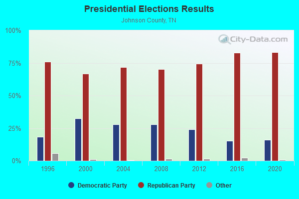
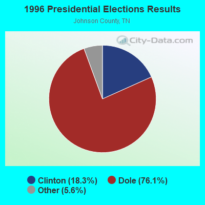


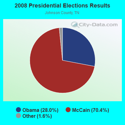
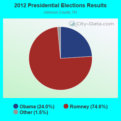
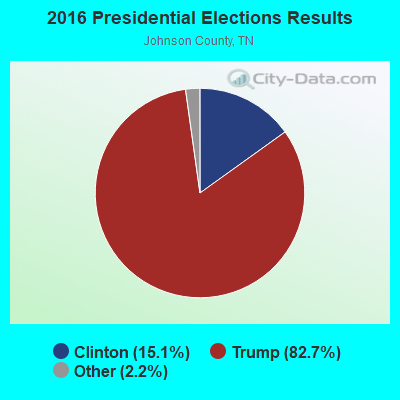
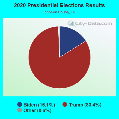
Graphs represent county-level data. Detailed 2008 Election Results
Religion statistics for Shady Valley, TN (based on Johnson County data)
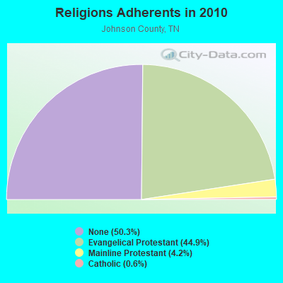
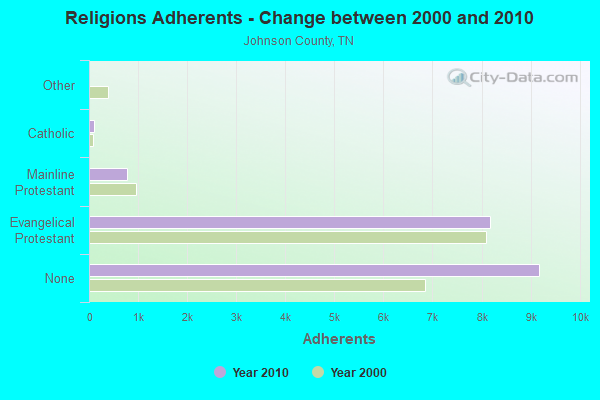
| Religion | Adherents | Congregations |
|---|---|---|
| Evangelical Protestant | 8,183 | 43 |
| Mainline Protestant | 769 | 10 |
| Catholic | 110 | 1 |
| Other | 1 | - |
| None | 9,181 | - |
Food Environment Statistics:
| Here: | 2.76 / 10,000 pop. |
| Tennessee: | 1.99 / 10,000 pop. |
| Johnson County: | 1.11 / 10,000 pop. |
| State: | 0.65 / 10,000 pop. |
| Here: | 3.32 / 10,000 pop. |
| Tennessee: | 5.16 / 10,000 pop. |
| This county: | 3.32 / 10,000 pop. |
| Tennessee: | 6.56 / 10,000 pop. |
| Johnson County: | 11.8% |
| Tennessee: | 11.4% |
| Here: | 31.8% |
| Tennessee: | 30.2% |
| This county: | 15.0% |
| Tennessee: | 13.5% |
Strongest AM radio stations in Shady Valley:
- WZAP (690 AM; 10 kW; BRISTOL, VA; Owner: RAM COMMUNICATIONS, INC.)
- WFHG (980 AM; 5 kW; BRISTOL, VA; Owner: BRISTOL BROADCASTING COMPANY, INC.)
- WGOC (640 AM; 10 kW; BLOUNTVILLE, TN; Owner: CITADEL BROADCASTING COMPANY)
- WBCV (1550 AM; 5 kW; BRISTOL, TN; Owner: SUNSHINE BROADCASTERS, INC.)
- WKSK (580 AM; 5 kW; W.JEFFERSON, NC; Owner: CADDELL BROADCASTING, INC.)
- WPWT (870 AM; daytime; 10 kW; COLONIAL HEIGHTS, TN; Owner: INFORMATION COMMUNICATIONS CORP.)
- WMCT (1390 AM; 1 kW; MOUNTAIN CITY, TN; Owner: JOHNSON COUNTY BROADCASTING CO,INC)
- WFGW (1010 AM; 50 kW; BLACK MOUNTAIN, NC; Owner: BLUE RIDGE BROADCASTING CORP.)
- WHGG (1090 AM; daytime; 10 kW; KINGSPORT, TN; Owner: APPALACHIAN EDUCATIONAL COMMUNICATIO)
- WXIT (1200 AM; daytime; 10 kW; BLOWING ROCK, NC; Owner: RONDINARO BROADCASTING, INC.)
- WHKY (1290 AM; 50 kW; HICKORY, NC; Owner: LONG COMMUNICATIONS, LLC.)
- WETB (790 AM; 5 kW; JOHNSON CITY, TN; Owner: MOUNTAIN SIGNALS, INC.)
- WTRU (830 AM; 50 kW; KERNERSVILLE, NC; Owner: TRUTH BROADCASTING CORPORATION)
Strongest FM radio stations in Shady Valley:
- WCQR-FM (88.3 FM; KINGSPORT, TN; Owner: POSITIVE ALTERNATIVE RADIO, INC.)
- WHCB (91.5 FM; BRISTOL, TN; Owner: APPALACHIAN EDUC. COMMUNICATION CORP)
- WETS-FM (89.5 FM; JOHNSON CITY, TN; Owner: EAST TENNESSEE STATE UNIVERSITY)
- WXBQ-FM (96.9 FM; BRISTOL, TN; Owner: BRISTOL BROADCASTING COMPANY, INC.)
- W214AP (90.7 FM; JOHNSON CITY, TN; Owner: THE MOODY BIBLE INSTITUTE OF CHICAGO)
- WPJO (99.3 FM; ELIZABETHTON, TN; Owner: BRISTOL BROADCASTING COMPANY, INC.)
- WECR-FM (102.3 FM; BEECH MOUNTAIN, NC; Owner: RONDINARO BROADCASTING, INC)
- WZJS (100.7 FM; BANNER ELK, NC; Owner: HIGHLAND COMMUNICATIONS ASSOCIATES, LLC)
- W285DG (104.9 FM; BOONE, NC; Owner: CITADEL BROADCASTING COMPANY)
- WFHG-FM (92.7 FM; ABINGDON, VA; Owner: BRISTOL BROADCASTING COMPANY, INC.)
- W225AA (92.9 FM; BOONE, NC; Owner: ISOTHERMAL COMMUNITY COLLEGE)
- WTFM (98.5 FM; KINGSPORT, TN; Owner: HOLSTON VALLEY BROADCASTING CORP.)
- WQUT (101.5 FM; JOHNSON CITY, TN; Owner: CITADEL BROADCASTING COMPANY)
- WMEV-FM (93.9 FM; MARION, VA; Owner: HOLSTON VALLEY BROADCASTING CORPORATION)
- WMIT (106.9 FM; BLACK MOUNTAIN, NC; Owner: BLUE RIDGE BROADCASTING CORPORATION)
- WNCW (88.7 FM; SPINDALE, NC; Owner: ISOTHERMAL COMMUNITY COLLEGE)
- WVTR (91.9 FM; MARION, VA; Owner: VIRGINIA TECH FOUNDATION INC)
- WOLD-FM (102.5 FM; MARION, VA; Owner: EMERALD SOUND, INC.)
- WRZK (95.9 FM; COLONIAL HEIGHTS, TN; Owner: MURRAY COMMUNICATIONS)
- WXLZ-FM (107.3 FM; LEBANON, VA; Owner: YEARY BROADCASTING, INC.)
TV broadcast stations around Shady Valley:
- WCYB-TV (Channel 5; BRISTOL, VA; Owner: APPALACHIAN BROADCASTING CORP.)
- WOPI-CA (Channel 9; BRISTOL,VA/KINGSPORT, TN; Owner: HOLSTON VALLEY BROADCASTING CORPORATION)
- WKPT-TV (Channel 19; KINGSPORT, TN; Owner: HOLSTON VALLEY BROADCASTING CORP.)
- WJHL-TV (Channel 11; JOHNSON CITY, TN; Owner: MEDIA GENERAL COMMUNICATIONS, INC.)
- WAPK-CA (Channel 36; BRISTOL,VA/KINGSPORT, TN; Owner: HOLSTON VALLEY BROADCASTING CORPORATION)
- W59AK (Channel 59; ZIONVILLE, NC; Owner: UNIVERSITY OF NORTH CAROLINA)
Shady Valley fatal accident list:
Dec 20, 2013 10:36 AM, Sr-133, Lat: 36.613697, Lon: -81.803892, Vehicles: 1, Persons: 2, Fatalities: 2
Apr 19, 1987 01:00 AM, Vehicles: 1, Persons: 2, Fatalities: 1
Sep 6, 1982 08:00 PM, S034010019, Vehicles: 1, Persons: 2, Fatalities: 1, Drunk persons involved: 1
Oct 30, 1982 00:05 AM, S133010036, Vehicles: 2, Persons: 2, Fatalities: 1, Drunk persons involved: 1
FCC Registered Cell Phone Towers:
1 (See the full list of FCC Registered Cell Phone Towers in Shady Valley)FCC Registered Antenna Towers:
15 (See the full list of FCC Registered Antenna Towers)FCC Registered Broadcast Land Mobile Towers:
1- Lat: 36.356056 Lon: -81.924611, Call Sign: WQEZ914,
Assigned Frequencies: 72.1400 MHz, Grant Date: 03/08/2016, Expiration Date: 05/30/2026, Certifier: Robert Sutherland, Registrant: Primex Wireless, Inc, 965 Wells St., Lake Geneva, WI 53147, Phone: (800) 537-0464, Fax: (262) 248-0061
FCC Registered Microwave Towers:
3- LOW GAP, 11441 Hwy 421 North (Lat: 36.530583 Lon: -81.946500), Type: Ltower, Structure height: 76.2 m, Overall height: 79.2 m, Call Sign: WQRK711,
Assigned Frequencies: 11365.0 MHz, Grant Date: 06/06/2013, Expiration Date: 06/06/2023, Cancellation Date: 05/05/2014, Certifier: Chris Harris, Registrant: Conterra Ultra Broadband, LLC, 2101 Rexford Rd, Ste 200e, Charlotte, NC 28211, Phone: (704) 936-1801, Fax: (704) 936-1801, Email:
- GRNDSTNE KNB, 11441 Highway 421 North (Lat: 36.530583 Lon: -81.946500), Type: Ltower, Structure height: 76.2 m, Overall height: 79.2 m, Call Sign: WQUM612,
Assigned Frequencies: 11585.0 MHz, Grant Date: 08/19/2014, Expiration Date: 08/19/2024, Certifier: John E Monday, Registrant: At&t Services, Inc., 208 S Akard St, 20f, Dallas, TX 75202, Phone: (855) 699-7073, Fax: (214) 746-6410, Email:
- NELLIE WHITE, 11152 Hwy 421 N (Lat: 36.533611 Lon: -81.943083), Type: Ltower, Structure height: 60 m, Overall height: 60.7 m, Call Sign: WRKL608,
Assigned Frequencies: 11545.0 MHz, 11585.0 MHz, Grant Date: 01/20/2021, Expiration Date: 01/20/2031, Certifier: Kevin Hetrick, Registrant: At&t Services, Inc., 208 S Akard St, 20f, Dallas, TX 75202, Phone: (855) 699-7073, Email:
FCC Registered Amateur Radio Licenses:
12 (See the full list of FCC Registered Amateur Radio Licenses in Shady Valley)FAA Registered Aircraft:
2- Aircraft: TEE AIR INC VANS AIRCRAFT RV8A (Category: Land, Seats: 2, Weight: Up to 12,499 Pounds), Engine: LYCOMING 0-320 SERIES (180 HP) (Reciprocating)
N-Number: 642FW, N642FW, N-642FW, Serial Number: 81186, Year manufactured: 2001, Airworthiness Date: 06/14/2001, Certificate Issue Date: 07/03/2019
Registrant (Individual): Thomas W Sharpe, 3004 Highway 133, Shady Valley, TN 37688 - Aircraft: DESTINY FUSION (Category: Land, Seats: 2, Weight: Up to 12,499 Pounds), Engine: ROTAX 582SER (65 HP) (2 Cycle)
N-Number: 75339, N75339, N-75339, Serial Number: 0008, Year manufactured: 2003, Airworthiness Date: 12/21/2007, Certificate Issue Date: 11/15/2007
Registrant (Individual): Charles M Mcqueen, 176 Mcqueen Rd, Shady Valley, TN 37688
2003 - 2018 National Fire Incident Reporting System (NFIRS) incidents
- Fire incident types reported to NFIRS in Shady Valley, TN
- 5443.5%Structure Fires
- 4737.9%Outside Fires
- 2016.1%Mobile Property/Vehicle Fires
- 32.4%Other
 According to the data from the years 2003 - 2018 the average number of fire incidents per year is 8. The highest number of reported fire incidents - 16 took place in 2007, and the least - 0 in 2010. The data has an increasing trend.
 When looking into fire subcategories, the most reports belonged to: Structure Fires (43.5%), and Outside Fires (37.9%).
- 37.3%Fuel oil, kerosene, etc.
- 34.2%Electricity
- 21.1%Wood
- 7.4%Bottled, tank, or LP gas

- 46.0%Fuel oil, kerosene, etc.
- 20.0%Wood
- 18.0%Electricity
- 16.0%Bottled, tank, or LP gas
Shady Valley compared to Tennessee state average:
- Unemployed percentage below state average.
- Black race population percentage significantly below state average.
- Hispanic race population percentage significantly below state average.
- Median age above state average.
- Foreign-born population percentage significantly below state average.
- Renting percentage significantly below state average.
- Length of stay since moving in significantly above state average.
- Number of rooms per house significantly below state average.
- House age significantly below state average.
- Number of college students below state average.
- Percentage of population with a bachelor's degree or higher significantly below state average.

|
Total of 2 patent applications in 2008-2024.