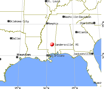
Sandersville, Mississippi
Submit your own pictures of this town and show them to the world
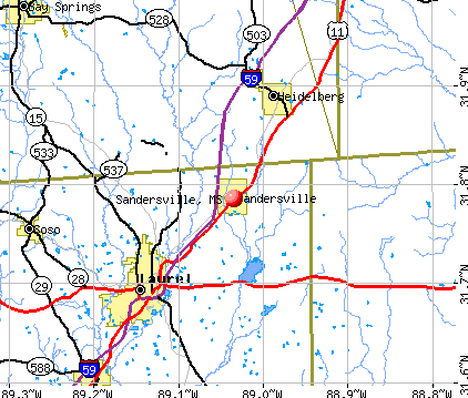
- OSM Map
- General Map
- Google Map
- MSN Map
Population change since 2000: -20.9%
 |
| Males: 339 | |
| Females: 285 |
| Median resident age: | 41.6 years |
| Mississippi median age: | 38.9 years |
Zip codes: 39477.
| Sandersville: | $53,486 |
| MS: | $52,719 |
Estimated per capita income in 2022: $27,024 (it was $14,429 in 2000)
Sandersville town income, earnings, and wages data
Estimated median house or condo value in 2022: $124,480 (it was $41,200 in 2000)
| Sandersville: | $124,480 |
| MS: | $162,500 |
Mean prices in 2022: all housing units: $134,247; detached houses: $175,794; mobile homes: $57,857
Median gross rent in 2022: $786.
(21.0% for White Non-Hispanic residents, 75.9% for Black residents, 50.0% for Hispanic or Latino residents)
Detailed information about poverty and poor residents in Sandersville, MS
Compare current foreclosures near Sandersville, MS:
| Photo | Address | Area | Beds / Baths | Price | Details |
|---|---|---|---|---|---|

|
#1
W Main St
Sandersville, MS 39477
|
- sq. feet
|
- baths - beds |
show details | |

|
#2
Lee St
Laurel, MS 39440
|
2,386 sq. feet
|
2 baths 3 beds |
$279,900
|
show details |

|
#3
Parker Dr
Laurel, MS 39440
|
3,029 sq. feet
|
4 baths 5 beds |
$269,900
|
show details |

|
#4
W 29th St
Laurel, MS 39440
|
962 sq. feet
|
1 baths 2 beds |
$69,000
|
show details |

|
#5
Wansley Rd
Laurel, MS 39443
|
2,444 sq. feet
|
2 baths 3 beds |
$219,000
|
show details |

|
#6
Warsaw Camp Loop
Laurel, MS 39443
|
1,920 sq. feet
|
2 baths 3 beds |
$99,900
|
show details |

|
#7
County Road 155
Stringer, MS 39481
|
1,568 sq. feet
|
1 baths - beds |
$39,900
|
show details |

|
#8
Mill St
Ellisville, MS 39437
|
1,169 sq. feet
|
1 baths 3 beds |
show details | |

|
#9
Billy Craft Rd
Laurel, MS 39443
|
3,312 sq. feet
|
4 baths 3 beds |
show details | |

|
#10
Rose Ln
Laurel, MS 39443
|
1,391 sq. feet
|
1 baths - beds |
show details |
| Photo | Address | Area | Beds / Baths | Price | Details |
|---|---|---|---|---|---|

|
#11
Sandy T Gavin Ave
Laurel, MS 39440
|
- sq. feet
|
- baths - beds |
$7,500
|
show details |

|
#12
County Road 1711
Stringer, MS 39481
|
1,910 sq. feet
|
1 baths - beds |
show details | |

|
#13
Highway 15
Stringer, MS 39481
|
1,602 sq. feet
|
1 baths - beds |
show details | |

|
#14
County Road 39
Vossburg, MS 39366
|
1,134 sq. feet
|
1 baths - beds |
show details | |

|
#15
Highway 11
Heidelberg, MS 39439
|
2,176 sq. feet
|
1 baths - beds |
show details | |

|
#16
Gum Ave
Heidelberg, MS 39439
|
2,105 sq. feet
|
1 baths - beds |
show details | |

|
#17
Wilshire Blvd
Laurel, MS 39443
|
2,303 sq. feet
|
- baths 4 beds |
show details | |

|
#18
Springdale Rd
Laurel, MS 39443
|
1,144 sq. feet
|
- baths - beds |
show details | |

|
#19
Indian Springs Rd # 1
Laurel, MS 39440
|
- sq. feet
|
- baths - beds |
show details | |

|
#20
Shady Oak Rd
Laurel, MS 39443
|
- sq. feet
|
- baths - beds |
show details |
| Photo | Address | Area | Beds / Baths | Price | Details |
|---|---|---|---|---|---|

|
#21
T Webber Dr
Laurel, MS 39443
|
- sq. feet
|
- baths - beds |
show details | |

|
#22
Highway 28 W
Laurel, MS 39443
|
- sq. feet
|
- baths - beds |
show details | |

|
#23
Highway 503
Vossburg, MS 39366
|
- sq. feet
|
- baths - beds |
show details | |

|
#24
Shubuta Eucutta Rd
Shubuta, MS 39360
|
- sq. feet
|
- baths - beds |
show details | |

|
#25
Shirley Dr
Ellisville, MS 39437
|
1,500 sq. feet
|
- baths - beds |
show details | |

|
#26
Shirley Dr
Ellisville, MS 39437
|
- sq. feet
|
- baths - beds |
show details | |

|
#27
Feed Mill Rd
Laurel, MS 39443
|
- sq. feet
|
- baths - beds |
show details | |

|
#28
County Road 14
Heidelberg, MS 39439
|
- sq. feet
|
- baths - beds |
show details | |

|
#29
Red Hill Florence Rd
Heidelberg, MS 39439
|
- sq. feet
|
- baths - beds |
show details | |

|
#30
Wildlife Lake Rd
Ovett, MS 39464
|
- sq. feet
|
- baths - beds |
show details |
| Photo | Address | Area | Beds / Baths | Price | Details |
|---|---|---|---|---|---|

|
#31
Rose Ln # 3
Laurel, MS 39443
|
- sq. feet
|
- baths - beds |
show details | |

|
#32
County Road 210
Shubuta, MS 39360
|
- sq. feet
|
- baths - beds |
show details | |

|
#33
Red Hill Florence Rd
Heidelberg, MS 39439
|
- sq. feet
|
- baths - beds |
show details | |

|
#34
Sandersville Sharon Rd # 1
Laurel, MS 39443
|
- sq. feet
|
- baths - beds |
show details | |

|
#35
Calvary Rd
Ellisville, MS 39437
|
1,054 sq. feet
|
- baths - beds |
show details | |

|
#36
Shady Oak Rd
Laurel, MS 39443
|
984 sq. feet
|
- baths - beds |
show details | |

|
#37
Shady Oak Rd
Laurel, MS 39443
|
1,176 sq. feet
|
- baths - beds |
show details | |

|
#38
Shubuta Eucutta Rd
Shubuta, MS 39360
|
- sq. feet
|
- baths - beds |
show details | |

|
#39
Gladiolus Dr
Laurel, MS 39440
|
1,200 sq. feet
|
- baths - beds |
show details | |

|
#40
Poplar Dr
Laurel, MS 39440
|
1,016 sq. feet
|
- baths - beds |
show details |
| Photo | Address | Area | Beds / Baths | Price | Details |
|---|---|---|---|---|---|

|
#41
Pearl River Dr
Laurel, MS 39440
|
- sq. feet
|
- baths - beds |
show details | |

|
#42
Smith Chapel Rd
Laurel, MS 39443
|
- sq. feet
|
- baths - beds |
show details | |

|
#43
County Road 35
Heidelberg, MS 39439
|
- sq. feet
|
- baths - beds |
show details | |

|
#44
Mcconkey St
Laurel, MS 39440
|
1,080 sq. feet
|
- baths - beds |
show details | |

|
#45
Julian St
Laurel, MS 39440
|
1,008 sq. feet
|
- baths - beds |
show details | |

|
#46
Lee St
Laurel, MS 39440
|
- sq. feet
|
- baths - beds |
show details | |

|
#47
Julian St
Laurel, MS 39440
|
- sq. feet
|
- baths - beds |
show details | |

|
#48
Rebecca St
Laurel, MS 39440
|
1,482 sq. feet
|
- baths - beds |
show details | |

|
#49
Neil Acres Rd
Laurel, MS 39443
|
2,429 sq. feet
|
- baths - beds |
show details | |

|
Check over 1 million property listings on Foreclosure.com!
|
browse all offers | |||


- 52491.9%White alone
- 284.9%Black alone
- 122.1%Hispanic

Races in Sandersville detailed stats: ancestries, foreign born residents, place of birth
According to our research of Mississippi and other state lists, there were 2 registered sex offenders living in Sandersville, Mississippi as of May 22, 2024.
The ratio of all residents to sex offenders in Sandersville is 425 to 1.
The ratio of registered sex offenders to all residents in this city is lower than the state average.
Type |
2020 |
2021 |
2022 |
|---|---|---|---|
| Murders (per 100,000) | 0 (0.0) | 0 (0.0) | 0 (0.0) |
| Rapes (per 100,000) | 0 (0.0) | 0 (0.0) | 0 (0.0) |
| Robberies (per 100,000) | 0 (0.0) | 1 (138.9) | 0 (0.0) |
| Assaults (per 100,000) | 2 (274.7) | 0 (0.0) | 0 (0.0) |
| Burglaries (per 100,000) | 12 (1,648) | 7 (972.2) | 2 (318.5) |
| Thefts (per 100,000) | 10 (1,374) | 17 (2,361) | 10 (1,592) |
| Auto thefts (per 100,000) | 2 (274.7) | 1 (138.9) | 5 (796.2) |
| Arson (per 100,000) | 0 (0.0) | 0 (0.0) | 0 (0.0) |
| City-Data.com crime index | 247.3 | 215.3 | 149.7 |
The City-Data.com crime index weighs serious crimes and violent crimes more heavily. Higher means more crime, U.S. average is 246.1. It adjusts for the number of visitors and daily workers commuting into cities.

Crime rate in Sandersville detailed stats: murders, rapes, robberies, assaults, burglaries, thefts, arson
Full-time law enforcement employees in 2020, including police officers: 15 (15 officers - 13 male; 2 female).
| Officers per 1,000 residents here: | 20.60 |
| Mississippi average: | 2.08 |
 Recent articles from our blog. Our writers, many of them Ph.D. graduates or candidates, create easy-to-read articles on a wide variety of topics.

Latest news from Sandersville, MS collected exclusively by city-data.com from local newspapers, TV, and radio stations
Ancestries: American (28.1%), English (16.7%), Irish (7.5%), Scotch-Irish (3.6%), German (2.8%), Scottish (2.2%).
Current Local Time: CST time zone
Elevation: 286 feet
Land area: 4.96 square miles.
Population density: 126 people per square mile (very low).
6 residents are foreign born
| This town: | 0.8% |
| Mississippi: | 1.4% |
Median real estate property taxes paid for housing units with mortgages in 2022: $1,734 (1.3%)
Median real estate property taxes paid for housing units with no mortgage in 2022: $1,298 (2.0%)
Nearest city with pop. 50,000+: Jackson, MS  (77.9 miles , pop. 184,256).
Nearest city with pop. 200,000+: New Orleans, LA (139.3 miles , pop. 484,674).
Nearest city with pop. 1,000,000+: Houston, TX (402.3 miles , pop. 1,953,631).
Nearest cities:
), ), ), Latitude: 31.79 N, Longitude: 89.03 W
Area code commonly used in this area: 601


Single-family new house construction building permits:
- 2006: 1 building, cost: $175,000
- 2005: 1 building, cost: $175,000
- 2004: 2 buildings, average cost: $131,000
| Here: | 2.5% |
| Mississippi: | 2.6% |
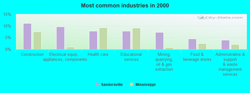
- Construction (11.2%)
- Electrical equipment, appliances, components (9.7%)
- Health care (7.9%)
- Educational services (7.9%)
- Mining, quarrying, oil & gas extraction (7.3%)
- Food & beverage stores (4.5%)
- Administrative & support & waste management services (3.9%)
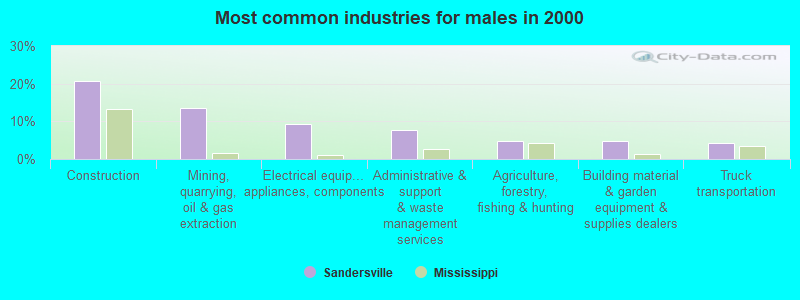
- Construction (20.6%)
- Mining, quarrying, oil & gas extraction (13.5%)
- Electrical equipment, appliances, components (9.4%)
- Administrative & support & waste management services (7.6%)
- Agriculture, forestry, fishing & hunting (4.7%)
- Building material & garden equipment & supplies dealers (4.7%)
- Truck transportation (4.1%)
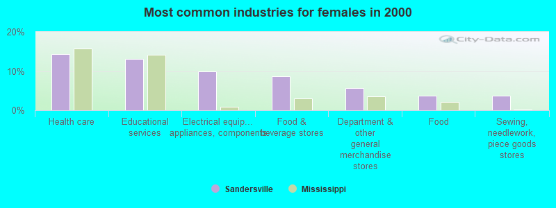
- Health care (14.4%)
- Educational services (13.1%)
- Electrical equipment, appliances, components (10.0%)
- Food & beverage stores (8.8%)
- Department & other general merchandise stores (5.6%)
- Food (3.8%)
- Sewing, needlework, piece goods stores (3.8%)

- Other production occupations, including supervisors (6.7%)
- Building and grounds cleaning and maintenance occupations (5.8%)
- Cashiers (4.8%)
- Retail sales workers, except cashiers (4.5%)
- Assemblers and fabricators (4.2%)
- Other sales and related occupations, including supervisors (3.9%)
- Other office and administrative support workers, including supervisors (3.6%)

- Building and grounds cleaning and maintenance occupations (8.2%)
- Other production occupations, including supervisors (7.6%)
- Carpenters (5.9%)
- Other material moving workers, except laborers (5.3%)
- Vehicle and mobile equipment mechanics, installers, and repairers (5.3%)
- Extraction workers (4.7%)
- Driver/sales workers and truck drivers (4.7%)

- Cashiers (10.0%)
- Retail sales workers, except cashiers (8.1%)
- Other office and administrative support workers, including supervisors (7.5%)
- Preschool, kindergarten, elementary, and middle school teachers (6.9%)
- Other sales and related occupations, including supervisors (5.6%)
- Secretaries and administrative assistants (5.6%)
- Other production occupations, including supervisors (5.6%)
Average climate in Sandersville, Mississippi
Based on data reported by over 4,000 weather stations


Tornado activity:
Sandersville-area historical tornado activity is near Mississippi state average. It is 111% greater than the overall U.S. average.
On 2/28/1987, a category F4 (max. wind speeds 207-260 mph) tornado 11.7 miles away from the Sandersville town center killed 6 people and injured 350 people and caused between $5,000,000 and $50,000,000 in damages.
On 12/28/1954, a category F3 (max. wind speeds 158-206 mph) tornado 2.3 miles away from the town center injured 25 people and caused between $500,000 and $5,000,000 in damages.
Earthquake activity:
Sandersville-area historical earthquake activity is significantly above Mississippi state average. It is 128% greater than the overall U.S. average.On 10/24/1997 at 08:35:17, a magnitude 4.9 (4.8 MB, 4.2 MS, 4.9 LG, Depth: 6.2 mi, Class: Light, Intensity: IV - V) earthquake occurred 113.6 miles away from the city center
On 1/18/1999 at 07:00:53, a magnitude 4.8 (4.8 MB, 4.0 LG, Depth: 0.6 mi) earthquake occurred 152.6 miles away from the city center
On 11/7/2004 at 11:20:21, a magnitude 4.3 (4.3 MW, Depth: 3.1 mi) earthquake occurred 87.9 miles away from the city center
On 6/24/1975 at 11:11:36, a magnitude 4.5 (4.5 MB) earthquake occurred 150.7 miles away from Sandersville center
On 3/25/1976 at 00:41:20, a magnitude 5.0 (4.9 MB, 5.0 LG, Class: Moderate, Intensity: VI - VII) earthquake occurred 276.6 miles away from Sandersville center
On 4/29/2003 at 08:59:39, a magnitude 4.9 (4.4 MB, 4.6 MW, 4.9 LG) earthquake occurred 272.0 miles away from Sandersville center
Magnitude types: regional Lg-wave magnitude (LG), body-wave magnitude (MB), surface-wave magnitude (MS), moment magnitude (MW)
Natural disasters:
The number of natural disasters in Jones County (22) is greater than the US average (15).Major Disasters (Presidential) Declared: 15
Emergencies Declared: 4
Causes of natural disasters: Floods: 9, Storms: 9, Tornadoes: 9, Hurricanes: 8, Heavy Rains: 2, Winds: 2, Drought: 1, Freeze: 1, Tropical Storm: 1, Other: 1 (Note: some incidents may be assigned to more than one category).

Hospitals and medical centers near Sandersville:
- SOUTH MISSISSIPPI STATE HOSPITAL (Hospital, about 8 miles away; LAUREL, MS)
- DAVISON REST HOME (Nursing Home, about 8 miles away; LAUREL, MS)
- LAUREL DIALYSIS (Dialysis Facility, about 8 miles away; LAUREL, MS)
- COMFORTCARE HOME HEALTH (Home Health Center, about 9 miles away; LAUREL, MS)
- COMFORT CARE HOSPICE (Hospital, about 9 miles away; LAUREL, MS)
- CCI PROFESSIONAL HEALTHCARE HOSPICE (Hospital, about 9 miles away; LAUREL, MS)
- ETERNITY HOSPICE, INC OF LAUREL (Hospital, about 9 miles away; LAUREL, MS)
Colleges/universities with over 2000 students nearest to Sandersville:
- Jones County Junior College (about 17 miles; Ellisville, MS; Full-time enrollment: 3,942)
- University of Southern Mississippi (about 37 miles; Hattiesburg, MS; FT enrollment: 14,294)
- William Carey University (about 37 miles; Hattiesburg, MS; FT enrollment: 3,510)
- Meridian Community College (about 44 miles; Meridian, MS; FT enrollment: 2,750)
- East Central Community College (about 46 miles; Decatur, MS; FT enrollment: 2,380)
- Mississippi Gulf Coast Community College (about 70 miles; Perkinston, MS; FT enrollment: 8,320)
- Pearl River Community College (about 72 miles; Poplarville, MS; FT enrollment: 3,074)
Points of interest:
Notable location: Sandersville Volunteer Fire Department (A). Display/hide its location on the map
Churches in Sandersville include: Mount Pleasant Baptist Church (A), Sandersville Baptist Church (B). Display/hide their locations on the map
Cemeteries: May Cemetery (1), Sandersville Cemetery (2). Display/hide their locations on the map
Streams, rivers, and creeks: Jim Kelly Branch (A). Display/hide its location on the map
Drinking water stations with addresses in Sandersville and their reported violations in the past:
BEAVER MEADOW WATER ASSN. (Population served: 1,727, Groundwater):Past health violations:ERATA WATER ASSOCIATION (Population served: 824, Groundwater):Past monitoring violations:
- MCL, Average - Between APR-2012 and JUN-2012, Contaminant: TTHM. Follow-up actions: St Formal NOV issued (AUG-31-2012), St Public Notif requested (AUG-31-2012), St Compliance achieved (SEP-19-2012), St Public Notif received (SEP-19-2012)
- MCL, Average - Between JAN-2012 and MAR-2012, Contaminant: TTHM. Follow-up actions: St AO (w/o penalty) issued (JAN-21-2009), St Formal NOV issued (MAY-18-2012), St Public Notif requested (MAY-18-2012), St Public Notif received (JUN-25-2012), St Compliance achieved (SEP-19-2012)
- MCL, Average - Between OCT-2011 and DEC-2011, Contaminant: TTHM. Follow-up actions: St AO (w/o penalty) issued (JAN-21-2009), St Formal NOV issued (MAR-08-2012), St Public Notif requested (MAR-08-2012), St Public Notif received (APR-03-2012), St Compliance achieved (SEP-19-2012)
- MCL, Average - Between OCT-2011 and DEC-2011, Contaminant: Total Haloacetic Acids (HAA5). Follow-up actions: St AO (w/o penalty) issued (JAN-21-2009), St Formal NOV issued (MAR-08-2012), St Public Notif requested (MAR-08-2012), St Public Notif received (APR-03-2012), St Compliance achieved (SEP-19-2012)
- MCL, Average - Between OCT-2009 and DEC-2009, Contaminant: TTHM. Follow-up actions: St AO (w/o penalty) issued (JAN-21-2009), St Compliance achieved (MAR-01-2010), St Formal NOV issued (MAR-03-2010), St Public Notif requested (MAR-03-2010), St Public Notif received (APR-01-2010)
- MCL, Average - Between JUL-2009 and SEP-2009, Contaminant: Total Haloacetic Acids (HAA5). Follow-up actions: St AO (w/o penalty) issued (JAN-21-2009), St Compliance achieved (JUL-16-2009), St Formal NOV issued (JAN-07-2010), St Public Notif requested (JAN-07-2010), St Public Notif received (FEB-10-2010)
- 34 other older health violations
- 261 regular monitoring violations
Past monitoring violations:
- 83 regular monitoring violations
| This town: | 2.4 people |
| Mississippi: | 2.6 people |
| This town: | 66.6% |
| Whole state: | 69.0% |
| This town: | 3.3% |
| Whole state: | 5.7% |
Likely homosexual households (counted as self-reported same-sex unmarried-partner households)
- Lesbian couples: 0.7% of all households
- Gay men: 0.0% of all households
Banks with branches in Sandersville (2011 data):
- Community Bank: Sandersville Branch at U.S. Highway 11, branch established on 1970/10/14. Info updated 2008/07/15: Bank assets: $630.6 mil, Deposits: $562.6 mil, headquarters in Ellisville, MS, positive income, Commercial Lending Specialization, 11 total offices, Holding Company: Community Bancshares Of Mississippi, Inc. Employee Stock Ownership Plan
For population 15 years and over in Sandersville:

- Never married: 22.3%
- Now married: 50.2%
- Separated: 2.7%
- Widowed: 6.9%
- Divorced: 17.9%
For population 25 years and over in Sandersville:
- High school or higher: 92.2%
- Bachelor's degree or higher: 24.2%
- Graduate or professional degree: 12.0%
- Unemployed: 3.8%
- Mean travel time to work (commute): 21.1 minutes


| Here: | 10.0 |
| Mississippi average: | 11.8 |


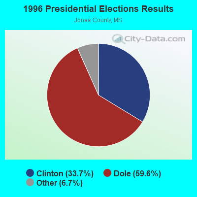


Graphs represent county-level data. Detailed 2008 Election Results
Religion statistics for Sandersville, MS (based on Jones County data)
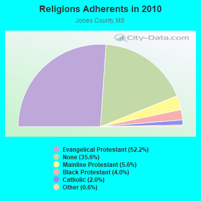
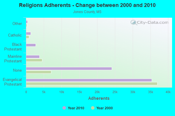
| Religion | Adherents | Congregations |
|---|---|---|
| Evangelical Protestant | 35,353 | 122 |
| Mainline Protestant | 3,811 | 26 |
| Black Protestant | 2,728 | 11 |
| Catholic | 1,350 | 1 |
| Other | 427 | 3 |
| None | 24,092 | - |
Food Environment Statistics:
| This county: | 2.40 / 10,000 pop. |
| Mississippi: | 2.08 / 10,000 pop. |
| Jones County: | 0.15 / 10,000 pop. |
| State: | 0.24 / 10,000 pop. |
| Jones County: | 0.15 / 10,000 pop. |
| Mississippi: | 0.80 / 10,000 pop. |
| Here: | 6.30 / 10,000 pop. |
| State: | 6.36 / 10,000 pop. |
| Here: | 2.85 / 10,000 pop. |
| Mississippi: | 5.03 / 10,000 pop. |
| Jones County: | 13.4% |
| State: | 12.3% |
| Jones County: | 34.6% |
| State: | 33.1% |
| This county: | 14.0% |
| State: | 14.4% |
Health and Nutrition:
| Here: | 62.0% |
| Mississippi: | 48.6% |
| Sandersville: | 64.9% |
| Mississippi: | 45.3% |
| Sandersville: | 27.6 |
| Mississippi: | 29.2 |
| This city: | 13.3% |
| State: | 20.5% |
| This city: | 6.9 |
| State: | 6.7 |
| Here: | 31.3% |
| State: | 34.8% |
| Sandersville: | 68.4% |
| Mississippi: | 54.9% |
| Here: | 82.0% |
| Mississippi: | 79.9% |
More about Health and Nutrition of Sandersville, MS Residents
| Local government employment and payroll (March 2022) | |||||
| Function | Full-time employees | Monthly full-time payroll | Average yearly full-time wage | Part-time employees | Monthly part-time payroll |
|---|---|---|---|---|---|
| Police Protection - Officers | 4 | $11,416 | $34,248 | 12 | $11,233 |
| Financial Administration | 3 | $5,923 | $23,692 | 0 | $0 |
| Sewerage | 1 | $4,308 | $51,696 | 0 | $0 |
| Water Supply | 1 | $3,372 | $40,464 | 0 | $0 |
| Parks and Recreation | 1 | $3,222 | $38,664 | 0 | $0 |
| Other Government Administration | 0 | $0 | 8 | $4,045 | |
| Judicial and Legal | 0 | $0 | 3 | $2,236 | |
| Totals for Government | 10 | $28,241 | $33,889 | 23 | $17,514 |
Sandersville government finances - Expenditure in 2017 (per resident):
- Current Operations - Police Protection: $226,000 ($362.18)
Financial Administration: $196,000 ($314.10)
Solid Waste Management: $181,000 ($290.06)
Water Utilities: $115,000 ($184.29)
Sewerage: $89,000 ($142.63)
Parks and Recreation: $12,000 ($19.23)
Local Fire Protection: $10,000 ($16.03)
- Total Salaries and Wages: $262,000 ($419.87)
Sandersville government finances - Revenue in 2017 (per resident):
- Charges - Sewerage: $46,000 ($73.72)
- Miscellaneous - General Revenue - Other: $75,000 ($120.19)
Fines and Forfeits: $57,000 ($91.35)
Interest Earnings: $5,000 ($8.01)
- Revenue - Water Utilities: $59,000 ($94.55)
- State Intergovernmental - General Local Government Support: $377,000 ($604.17)
Other: $13,000 ($20.83)
Highways: $2,000 ($3.21)
- Tax - Property: $133,000 ($213.14)
Public Utilities Sales: $41,000 ($65.71)
Other License: $5,000 ($8.01)
Sandersville government finances - Cash and Securities in 2017 (per resident):
- Other Funds - Cash and Securities: $456,000 ($730.77)
Strongest AM radio stations in Sandersville:
- WSJC (810 AM; 50 kW; MAGEE, MS; Owner: FAMILY TALK RADIO)
- WEEZ (890 AM; daytime; 10 kW; LAUREL, MS; Owner: CLEAR CHANNEL BROADCASTING LICENSES, INC.)
- WJNT (1180 AM; 50 kW; PEARL, MS; Owner: BUCHANAN BROADCASTING CO., INC.)
- WAML (1340 AM; 1 kW; LAUREL, MS; Owner: PINE BELT BROADCASTING, INC.)
- WQST (850 AM; daytime; 10 kW; FOREST, MS; Owner: ACE BROADCASTING, INC.)
- WIZK (1570 AM; daytime; 3 kW; BAY SPRINGS, MS; Owner: M. JEROME HUGHEY)
- WBKH (950 AM; 5 kW; HATTIESBURG, MS; Owner: SOUTHERN AIR COMMUNICATIONS, INC.)
- WMOX (1010 AM; 10 kW; MERIDIAN, MS; Owner: MAGNOLIA STATE B/C CO., INC.)
- WASG (550 AM; 25 kW; ATMORE, AL; Owner: 550 AM, INC)
- WOMN (1110 AM; daytime; 30 kW; FRANKLINTON, LA; Owner: PITTMAN BROADCASTING SERVICES, LLC.)
- WWL (870 AM; 50 kW; NEW ORLEANS, LA; Owner: ENTERCOM NEW ORLEANS LICENSE, LLC)
- WJOX (690 AM; 50 kW; BIRMINGHAM, AL; Owner: CITADEL BROADCASTING COMPANY)
- WALT (910 AM; 5 kW; MERIDIAN, MS; Owner: NEW SOUTH COMMUNICATIONS, INC.)
Strongest FM radio stations in Sandersville:
- WATP (90.7 FM; LAUREL, MS; Owner: AMERICAN FAMILY ASSOCIATION)
- WJKX (102.5 FM; ELLISVILLE, MS; Owner: CLEAR CHANNEL BROADCASTING LICENSES, INC.)
- WNSL (100.3 FM; LAUREL, MS; Owner: CLEAR CHANNEL BROADCASTING LICENSES, INC.)
- W218AY (91.5 FM; LAUREL, MS; Owner: BIBLE BROADCASTING NETWORK, INC.)
- WUSW (103.7 FM; HATTIESBURG, MS; Owner: CLEAR CHANNEL BROADCASTING LICENSES, INC.)
- WMAW-FM (88.1 FM; MERIDIAN, MS; Owner: MISSISSIPPI AUTHORITY FOR EDUCATIONAL TV)
- WXRR (104.5 FM; HATTIESBURG, MS; Owner: BLAKENEY COMMUNICATIONS, INC.)
- WKZW (94.3 FM; SANDERSVILLE, MS; Owner: BLAKENEY COMMUNICATIONS, INC.)
- WHER (99.3 FM; HEIDELBERG, MS; Owner: CLEAR CHANNEL BROADCASTING LICENSES, INC.)
- WMXI (98.1 FM; LAUREL, MS; Owner: RAINEY BROADCASTING, INC.)
- WQST-FM (92.5 FM; FOREST, MS; Owner: AMERICAN FAMILY ASSOCIATION, INC.)
- WBBN (95.9 FM; TAYLORSVILLE, MS; Owner: BLAKENEY COMMUNICATIONS, INC)
- WOKK (97.1 FM; MERIDIAN, MS; Owner: NEW SOUTH COMMUNICATIONS, INC.)
- WZLD (106.3 FM; PETAL, MS; Owner: CLEAR CHANNEL BROADCASTING LICENSES, INC.)
- WXHB (96.5 FM; RICHTON, MS; Owner: RADIO BROADCASTERS, L.L.C.)
- WYKK-FM (98.9 FM; QUITMAN, MS; Owner: QUITMAN BROADCASTING COMPANY)
TV broadcast stations around Sandersville:
- W69DJ (Channel 69; MERIDIAN, MS; Owner: MS COMMUNICATIONS, LLC)
- WMAW-TV (Channel 14; MERIDIAN, MS; Owner: MISSISSIPPI AUTHORITY FOR EDUCATIONAL TV)
- W36CU (Channel 36; MERIDIAN, MS; Owner: MS COMMUNICATIONS, LLC)
- W46CL (Channel 46; MERIDIAN, MS; Owner: MS COMMUNICATIONS, LLC)
- W52DE (Channel 52; MERIDIAN, MS; Owner: MS COMMUNICATIONS, LLC)
- W65DE (Channel 65; MERIDIAN, MS; Owner: MS COMMUNICATIONS, LLC)
- WDAM-TV (Channel 7; LAUREL, MS; Owner: WDAM LICENSE SUBSIDIARY, INC.)
- WHLT (Channel 22; HATTIESBURG, MS; Owner: MEDIA GENERAL COMMUNICATIONS, INC.)
- W52CS (Channel 52; MERIDIAN, MS; Owner: MS COMMUNICATIONS, LLC)
- W59DE (Channel 59; MERIDIAN, MS; Owner: MS COMMUNICATIONS, LLC)
- W53CE (Channel 53; MERIDIAN, MS; Owner: MS COMMUNICATIONS, LLC)
- W34CH (Channel 34; MERIDIAN, MS; Owner: MS COMMUNICATIONS, LLC)
Sandersville fatal accident list:
Feb 23, 1995 11:08 PM, West Main, Vehicles: 1, Persons: 1, Fatalities: 1
Oct 10, 1995 06:34 PM, E Main St, Vehicles: 1, Persons: 1, Fatalities: 1, Drunk persons involved: 1
Sep 15, 1989 07:45 AM, 341439, Vehicles: 1, Persons: 1, Fatalities: 1
Jul 24, 1978 07:30 AM, Vehicles: 1, Persons: 1, Fatalities: 1
- National Bridge Inventory (NBI) Statistics
- 33Number of bridges
- 413ft / 126mTotal length
- $4,530,313,000Total costs
- 91,476Total average daily traffic
- 12,820Total average daily truck traffic

- New bridges - historical statistics
- 41930-1939
- 121960-1969
- 41980-1989
- 21990-1999
- 72000-2009
- 32010-2019
- 12020-2022
FCC Registered Antenna Towers:
23 (See the full list of FCC Registered Antenna Towers in Sandersville)FCC Registered Broadcast Land Mobile Towers:
3- City Hall (Lat: 31.787389 Lon: -89.033667), Call Sign: KNED407, Licensee ID: L00382399,
Assigned Frequencies: 45.2200 MHz, Grant Date: 11/26/2002, Expiration Date: 11/30/2012, Cancellation Date: 06/10/2004, Registrant: Sandersville, Town Of, Sandersville, MS 39477, Phone: (601) 649-3068
- Comp Sta 80 Gas Plant Rd (Lat: 31.814611 Lon: -89.050611), Call Sign: KKD611,
Assigned Frequencies: 48.7400 MHz, Grant Date: 12/18/2014, Expiration Date: 01/04/2025, Certifier: Michael A Vicknair, Registrant: Williams - Engineering & Integration, 295 Chipeta Way, Salt Lake City, UT 84108, Phone: (801) 584-6068, Fax: (713) 215-2266, Email:
- MOBILES L1, Lat: 31.768333 Lon: -89.060833, Call Sign: KFF634,
Assigned Frequencies: 160.950 MHz, 161.535 MHz, Grant Date: 08/19/2014, Expiration Date: 07/21/2024, Registrant: Alabama Great Southern Railroad Company, 650 West Peachtree St, Nw, Box 41, Atlanta, GA 30308, Phone: (404) 660-4050, Fax: (404) 582-6209, Email:
FCC Registered Microwave Towers:
4- STATION, Compressor Stn 80 Gas Plant Rd (Lat: 31.814583 Lon: -89.050583), Overall height: 122.8 m, Call Sign: WNEU951,
Assigned Frequencies: 952.262 MHz, 928.262 MHz, Grant Date: 04/25/2018, Expiration Date: 05/31/2028, Certifier: Michael A Vicknair, Registrant: Williams - Engineering & Integration, 295 Chipeta Way, Salt Lake City, UT 84108, Phone: (801) 584-6068, Fax: (713) 215-2266, Email:
- STATION, Compressor Sta 80 Gas Plant Rd (Lat: 31.814583 Lon: -89.050583), Overall height: 121.9 m, Call Sign: KKC53,
Assigned Frequencies: 1855.00 MHz, 1895.00 MHz, Grant Date: 10/24/1995, Expiration Date: 09/23/1998, Cancellation Date: 04/22/1997, Phone: (713) 439-2750
- Errata, On Gravel Road, 1.1 Mi. S Of Int. Of Sr 537 & Claiborne Rd In Sandersville (Lat: 31.768333 Lon: -89.060833), Type: Ltower, Structure height: 63.4 m, Overall height: 64.9 m, Call Sign: KQZ69,
Assigned Frequencies: 6256.54 MHz, 6226.89 MHz, Grant Date: 05/13/2020, Expiration Date: 07/05/2030, Registrant: Norfolk Southern, 650 West Peachtree St Nw, Atlanta, GA 30308, Phone: (404) 582-6244, Email:
- SANDERSVILLE, 2.2 Mi Nnw Of (Lat: 31.814583 Lon: -89.050583), Type: Tower, Structure height: 122.8 m, Call Sign: WAH533,
Assigned Frequencies: 5945.20 MHz, 6063.80 MHz, 6004.50 MHz, 6063.80 MHz, 6123.10 MHz, 5945.20 MHz, 6004.50 MHz, 6123.10 MHz, 6152.75 MHz, Grant Date: 01/25/2011, Expiration Date: 02/01/2021, Cancellation Date: 03/18/2014, Registrant: Verizon Wireless, 1120 Sanctuary Pkwy, #150 Gasa5reg, Alpharetta, GA 30009-7630, Phone: (770) 797-1070, Fax: (770) 797-1036, Email:
FCC Registered Amateur Radio Licenses:
5- Call Sign: KC5LOZ, Licensee ID: L00924802, Grant Date: 11/11/2014, Expiration Date: 12/21/2024, Registrant: Richard Kelley, Sandersville, MS 39477
- Call Sign: K5ZRK, Previous Call Sign: WB5KYK, Licensee ID: L00132325, Grant Date: 05/11/2007, Expiration Date: 05/11/2017, Cancellation Date: 05/14/2019, Certifier: Larry D Jones, Registrant: Larry D Jones, Sandersville, MS 39477
- Call Sign: KE5PKL, Licensee ID: L01302841, Grant Date: 07/10/2007, Expiration Date: 07/10/2017, Cancellation Date: 07/11/2019, Certifier: Minnie S Pates, Registrant: Minnie S Pates, Sandersville, MS 39447
- Call Sign: KE7SVS, Licensee ID: L01383669, Grant Date: 03/26/2008, Expiration Date: 03/26/2018, Cancellation Date: 01/23/2009, Certifier: Linda C Abbott, Registrant: Linda C Abbott, Sandersville, MS 39477
- Call Sign: KF5HLM, Licensee ID: L01577255, Grant Date: 06/18/2010, Expiration Date: 06/18/2020, Cancellation Date: 06/22/2022, Certifier: Shirley A Strunk, Registrant: Shirley A Strunk, Sandersville, MS 39477
2003 - 2018 National Fire Incident Reporting System (NFIRS) incidents
- Fire incident types reported to NFIRS in Sandersville, MS
- 23952.4%Outside Fires
- 12527.4%Structure Fires
- 5612.3%Mobile Property/Vehicle Fires
- 367.9%Other
 Based on the data from the years 2003 - 2018 the average number of fire incidents per year is 28. The highest number of fires - 61 took place in 2006, and the least - 2 in 2018. The data has a declining trend.
 When looking into fire subcategories, the most reports belonged to: Outside Fires (52.4%), and Structure Fires (27.4%).
| Most common first names in Sandersville, MS among deceased individuals | ||
| Name | Count | Lived (average) |
|---|---|---|
| John | 11 | 74.2 years |
| James | 10 | 65.5 years |
| William | 9 | 78.6 years |
| Mary | 6 | 68.7 years |
| Jessie | 5 | 80.2 years |
| Joseph | 5 | 64.0 years |
| Robert | 5 | 77.2 years |
| Betty | 4 | 63.3 years |
| Lawrence | 4 | 66.5 years |
| Harold | 4 | 68.2 years |
| Most common last names in Sandersville, MS among deceased individuals | ||
| Last name | Count | Lived (average) |
|---|---|---|
| Hill | 14 | 65.3 years |
| Jones | 10 | 61.6 years |
| Hinton | 9 | 78.9 years |
| Holifield | 9 | 72.6 years |
| Smith | 9 | 80.1 years |
| Herrington | 8 | 67.6 years |
| Hickson | 8 | 76.2 years |
| Parker | 7 | 71.2 years |
| Myrick | 7 | 77.0 years |
| Johnson | 7 | 77.6 years |


Sandersville compared to Mississippi state average:
- Unemployed percentage significantly below state average.
- Black race population percentage significantly below state average.
- Hispanic race population percentage below state average.
- Median age significantly above state average.
- Foreign-born population percentage significantly below state average.
- Renting percentage below state average.
- Length of stay since moving in significantly above state average.
- Number of college students below state average.