Saloma, Kentucky
Submit your own pictures of this place and show them to the world
- OSM Map
- General Map
- Google Map
- MSN Map

| Males: 1,541 | |
| Females: 1,485 |
| Median resident age: | 38.0 years |
| Kentucky median age: | 35.9 years |
Zip code: 42718
| Saloma: | $64,135 |
| KY: | $59,341 |
Estimated per capita income in 2022: $26,923 (it was $13,466 in 2000)
Saloma CCD income, earnings, and wages data
Estimated median house or condo value in 2022: $188,306 (it was $75,800 in 2000)
| Saloma: | $188,306 |
| KY: | $196,300 |
Mean prices in 2022: all housing units: $205,591; detached houses: $212,647; townhouses or other attached units: $214,880; in 2-unit structures: $219,199; mobile homes: $117,181
Detailed information about poverty and poor residents in Saloma, KY


- 2,79797.2%White alone
- 411.4%Black alone
- 200.7%Hispanic
- 170.6%Two or more races
- 20.07%Asian alone
- 10.03%American Indian alone
- 10.03%Native Hawaiian and Other
Pacific Islander alone

Races in Saloma detailed stats: ancestries, foreign born residents, place of birth
 Recent articles from our blog. Our writers, many of them Ph.D. graduates or candidates, create easy-to-read articles on a wide variety of topics.
Current Local Time: EST time zone
Elevation: 880 feet
Land area: 88.9 square miles.
Population density: 34 people per square mile (very low).

| Saloma CCD: | 0.6% ($419) |
| Kentucky: | 0.8% ($610) |
Nearest city with pop. 50,000+: Louisville, KY  (57.2 miles , pop. 256,231).
Nearest city with pop. 1,000,000+: Chicago, IL (326.9 miles , pop. 2,896,016).
Nearest cities:
), ), ), ), ), )Latitude: 37.44 N, Longitude: 85.44 W
Area code commonly used in this area: 270


| Here: | 3.3% |
| Kentucky: | 3.8% |

- Construction (12.9%)
- Educational services (8.5%)
- Agriculture, forestry, fishing & hunting (7.1%)
- Wood products (6.8%)
- Accommodation & food services (6.4%)
- Health care (5.4%)
- Professional, scientific, technical services (4.0%)

- Construction (20.5%)
- Agriculture, forestry, fishing & hunting (10.4%)
- Wood products (10.3%)
- Metal & metal products (6.9%)
- Accommodation & food services (5.0%)
- Machinery (4.2%)
- Transportation equipment (3.8%)

- Educational services (15.2%)
- Health care (8.4%)
- Finance & insurance (8.4%)
- Accommodation & food services (8.3%)
- Professional, scientific, technical services (6.6%)
- Department & other general merchandise stores (5.6%)
- Food & beverage stores (4.9%)

- Other production occupations, including supervisors (6.2%)
- Farmers and farm managers (5.2%)
- Metal workers and plastic workers (4.6%)
- Electrical equipment mechanics and other installation, maintenance, and repair workers, including supervisors (4.0%)
- Other management occupations, except farmers and farm managers (3.8%)
- Retail sales workers, except cashiers (3.8%)
- Construction traders workers except carpenters, electricians, painters, plumbers, and construction laborers (3.8%)

- Farmers and farm managers (8.2%)
- Metal workers and plastic workers (8.2%)
- Other production occupations, including supervisors (8.0%)
- Electrical equipment mechanics and other installation, maintenance, and repair workers, including supervisors (7.0%)
- Construction traders workers except carpenters, electricians, painters, plumbers, and construction laborers (6.6%)
- Carpenters (4.8%)
- Woodworkers (4.2%)

- Secretaries and administrative assistants (7.8%)
- Retail sales workers, except cashiers (7.6%)
- Preschool, kindergarten, elementary, and middle school teachers (6.9%)
- Building and grounds cleaning and maintenance occupations (5.1%)
- Other management occupations, except farmers and farm managers (4.9%)
- Cooks and food preparation workers (4.9%)
- Other sales and related occupations, including supervisors (4.7%)
Average climate in Saloma, Kentucky
Based on data reported by over 4,000 weather stations


Tornado activity:
Saloma-area historical tornado activity is slightly above Kentucky state average. It is 46% greater than the overall U.S. average.
On 4/3/1974, a category F4 (max. wind speeds 207-260 mph) tornado 15.2 miles away from the Saloma place center injured 56 people and caused between $500,000 and $5,000,000 in damages.
On 4/27/1971, a category F4 tornado 19.9 miles away from the place center killed 6 people and injured 58 people.
Earthquake activity:
Saloma-area historical earthquake activity is significantly above Kentucky state average. It is 118% greater than the overall U.S. average.On 7/27/1980 at 18:52:21, a magnitude 5.2 (5.1 MB, 4.7 MS, 5.0 UK, 5.2 UK, Class: Moderate, Intensity: VI - VII) earthquake occurred 97.6 miles away from Saloma center
On 4/18/2008 at 09:36:59, a magnitude 5.4 (5.1 MB, 4.8 MS, 5.4 MW, 5.2 MW) earthquake occurred 150.6 miles away from Saloma center
On 4/18/2008 at 09:36:59, a magnitude 5.2 (5.2 MW, Depth: 8.9 mi) earthquake occurred 150.6 miles away from Saloma center
On 6/18/2002 at 17:37:15, a magnitude 5.0 (4.3 MB, 4.6 MW, 5.0 LG) earthquake occurred 133.4 miles away from the city center
On 6/10/1987 at 23:48:54, a magnitude 5.1 (4.9 MB, 4.4 MS, 4.6 MS, 5.1 LG) earthquake occurred 163.7 miles away from the city center
On 9/7/1988 at 02:28:09, a magnitude 4.6 (4.5 MB, 4.6 LG, Class: Light, Intensity: IV - V) earthquake occurred 98.4 miles away from the city center
Magnitude types: regional Lg-wave magnitude (LG), body-wave magnitude (MB), surface-wave magnitude (MS), moment magnitude (MW)
Natural disasters:
The number of natural disasters in Taylor County (15) is near the US average (15).Major Disasters (Presidential) Declared: 11
Emergencies Declared: 3
Causes of natural disasters: Floods: 7, Storms: 6, Tornadoes: 5, Winter Storms: 4, Mudslides: 2, Blizzard: 1, Freeze: 1, Hurricane: 1, Landslide: 1, Snow: 1, Snowfall: 1, Snowstorm: 1, Wind: 1, Other: 1 (Note: some incidents may be assigned to more than one category).
Hospitals and medical centers near Saloma:
- TAYLOR REGIONAL HOSPITAL Acute Care Hospitals (about 8 miles away; CAMPBELLSVILLE, KY)
- CAMPBELLSVILLE NURSING AND REHABILITATION CENTER (Nursing Home, about 8 miles away; CAMPBELLSVILLE, KY)
- DAVITA - TAYLOR COUNTY DIALYSIS (Dialysis Facility, about 8 miles away; CAMPBELLSVILLE, KY)
- METZMEIER NH (Nursing Home, about 9 miles away; CAMPBELLSVILLE, KY)
- SPRING VIEW HOSPITAL Acute Care Hospitals (about 14 miles away; LEBANON, KY)
- GOLDEN LIVINGCENTER-GREEN HILL (Nursing Home, about 14 miles away; GREENSBURG, KY)
- GREEN HILL MANOR (Nursing Home, about 14 miles away; GREENSBURG, KY)
Colleges/universities with over 2000 students nearest to Saloma:
- Campbellsville University (about 9 miles; Campbellsville, KY; Full-time enrollment: 2,948)
- Lindsey Wilson College (about 25 miles; Columbia, KY; FT enrollment: 2,552)
- Elizabethtown Community and Technical College (about 30 miles; Elizabethtown, KY; FT enrollment: 3,762)
- Somerset Community College (about 53 miles; Somerset, KY; FT enrollment: 4,698)
- Sullivan University (about 56 miles; Louisville, KY; FT enrollment: 5,129)
- Bellarmine University (about 56 miles; Louisville, KY; FT enrollment: 3,180)
- University of Louisville (about 57 miles; Louisville, KY; FT enrollment: 16,640)
Points of interest:
Churches in Saloma include: Good Hope Baptist Church (A), Zion Separate Baptist Church (B), Mount Carmel Church (C), Mount Roberts Church (D), Our Lady of the Hills Church (E), Pleasant Union Church (F), Poplar Grove Church (G), Earlys Chapel (H). Display/hide their locations on the map
Cemeteries: Underwood Cemetery (1), Brookman Cemetery (2), Webster Cemetery (3), Colvin Cemetery (4), Cowherd Cemetery (5), Dewitt Cemetery (6), Kerr Cemetery (7). Display/hide their locations on the map
Reservoirs: Porter Reservoir (A), Ferrill Reservoir (B). Display/hide their locations on the map
Streams, rivers, and creeks: Mill Creek (A), Craig Creek (B), Willowtown Creek (C), Splatter Branch (D), Bull Tail Creek (E), Locust Lick Branch (F), Jones Creek (G), Owl Creek (H), Flat Run (I). Display/hide their locations on the map
| This place: | 2.5 people |
| Kentucky: | 2.5 people |
| This place: | 75.4% |
| Whole state: | 66.9% |
| This place: | 4.5% |
| Whole state: | 6.4% |
Likely homosexual households (counted as self-reported same-sex unmarried-partner households)
- Lesbian couples: 0.0% of all households
- Gay men: 0.2% of all households
| This place: | 18.2% |
| Whole state: | 15.8% |
| This place: | 6.5% |
| Whole state: | 6.6% |
For population 15 years and over in Saloma:

- Never married: 15.0%
- Now married: 68.3%
- Separated: 0.9%
- Widowed: 7.9%
- Divorced: 8.8%
For population 25 years and over in Saloma:
- High school or higher: 59.7%
- Bachelor's degree or higher: 12.3%
- Graduate or professional degree: 6.1%
- Unemployed: 3.4%
- Mean travel time to work (commute): 25.0 minutes


| Here: | 19.4 |
| Kentucky average: | 13.8 |
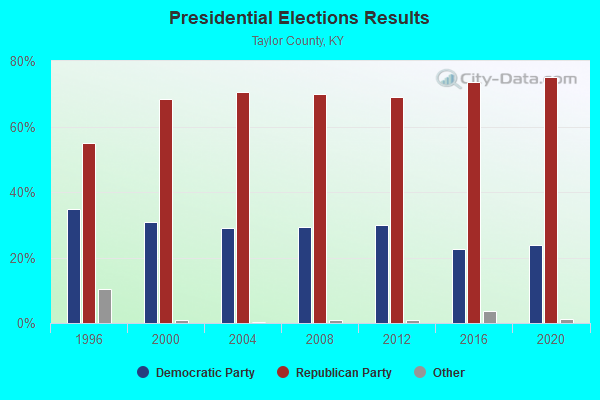
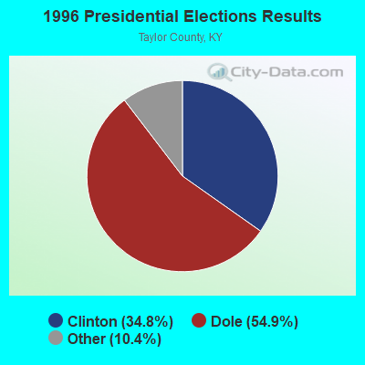


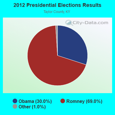
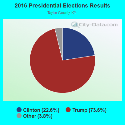
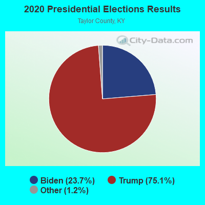
Graphs represent county-level data. Detailed 2008 Election Results
Religion statistics for Saloma, KY (based on Taylor County data)
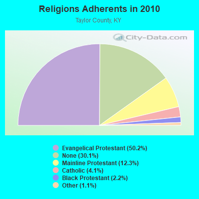
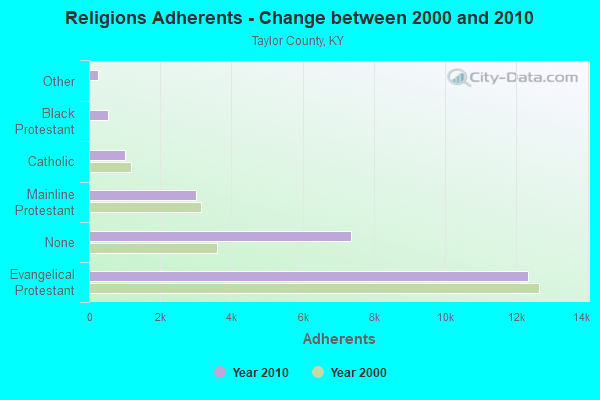
| Religion | Adherents | Congregations |
|---|---|---|
| Evangelical Protestant | 12,317 | 47 |
| Mainline Protestant | 3,008 | 18 |
| Catholic | 1,015 | 2 |
| Black Protestant | 546 | 3 |
| Other | 259 | 2 |
| None | 7,367 | - |
Food Environment Statistics:
| Taylor County: | 3.76 / 10,000 pop. |
| State: | 2.19 / 10,000 pop. |
| Taylor County: | 0.42 / 10,000 pop. |
| Kentucky: | 0.25 / 10,000 pop. |
| Taylor County: | 0.42 / 10,000 pop. |
| Kentucky: | 0.74 / 10,000 pop. |
| Taylor County: | 5.86 / 10,000 pop. |
| State: | 4.36 / 10,000 pop. |
| Here: | 5.86 / 10,000 pop. |
| State: | 5.74 / 10,000 pop. |
| Taylor County: | 11.3% |
| State: | 11.0% |
| Taylor County: | 28.3% |
| Kentucky: | 30.0% |
| This county: | 14.2% |
| Kentucky: | 15.9% |
Strongest AM radio stations in Saloma:
- WHAS (840 AM; 50 kW; LOUISVILLE, KY; Owner: CLEAR CHANNEL BROADCASTING LICENSES, INC.)
- WTCO (1450 AM; 1 kW; CAMPBELLSVILLE, KY; Owner: CBC OF MARION & TAYLOR COUNTIES INC)
- WSM (650 AM; 50 kW; NASHVILLE, TN; Owner: GAYLORD ENTERTAINMENT COMPANY)
- WAKY (1540 AM; 1 kW; GREENSBURG, KY; Owner: GREEN COUNTY CBC, INC.)
- WKVL (850 AM; daytime; 50 kW; KNOXVILLE, TN; Owner: HORNE RADIO, LLC)
- WAMB (1160 AM; 50 kW; DONELSON, TN; Owner: GREAT SOUTHERN BROADCASTING COMPANY, INC.)
- WLW (700 AM; 50 kW; CINCINNATI, OH; Owner: JACOR BROADCASTING CORPORATION)
- WKDA (1200 AM; 50 kW; NASHVILLE, TN; Owner: RADIO NASHVILLE, INC.)
- WLAC (1510 AM; 50 kW; NASHVILLE, TN; Owner: CAPSTAR TX LIMITED PARTNERSHIP)
- WNQM (1300 AM; 50 kW; NASHVILLE, TN; Owner: WNQM. INC.)
- WXAM (1430 AM; 1 kW; BUFFALO, KY; Owner: MARK GOODMAN PRODUCTIONS, INC.)
- WLBN (1590 AM; 1 kW; LEBANON, KY; Owner: CBC OF MARION COUNTY, INC)
- WKJK (1080 AM; 10 kW; LOUISVILLE, KY; Owner: CLEAR CHANNEL BROADCASTING LICENSES, INC.)
Strongest FM radio stations in Saloma:
- WVLC (99.9 FM; MANNSVILLE, KY; Owner: PATRICIA RODGERS)
- WCKQ (104.1 FM; CAMPBELLSVILLE, KY; Owner: CBC OF MARION & TAYLOR COUNTIES INC)
- WGRK-FM (103.1 FM; GREENSBURG, KY; Owner: GREEN COUNTY CBC, INC.)
- WAPD (91.7 FM; CAMPBELLSVILLE, KY; Owner: AMERICAN FAMILY ASSOCIATION)
- WAKY-FM (102.7 FM; SPRINGFIELD, KY; Owner: WASHINGTON COUNTY CBC, INC.)
- WLSK (100.9 FM; LEBANON, KY; Owner: CBC OF MARION COUNTY, INC)
- WDCL-FM (89.7 FM; SOMERSET, KY; Owner: WESTERN KENTUCKY UNIVERSITY)
- WXKY-FM (96.3 FM; STANFORD, KY; Owner: LINCOLN-GARRARD BROADCASTING CO.,INC)
- WASE (103.5 FM; RADCLIFF, KY; Owner: W & B BROADCASTING, INC.)
- WKUE (90.9 FM; ELIZABETHTOWN, KY; Owner: WESTERN KENTUCKY UNIVERSITY)
- WKMO (106.3 FM; HODGENVILLE, KY; Owner: ELIZABETHTOWN CBC, INC.)
- WQXE (98.3 FM; ELIZABETHTOWN, KY; Owner: SKYTOWER COMMUNICATIONS-E'TOWN, INC.)
TV broadcast stations around Saloma:
- WBKI-TV (Channel 34; CAMPBELLSVILLE, KY; Owner: LOUISVILLE COMMUNICATIONS, LLC)
- W04BP (Channel 4; CAMPBELLSVILLE, KY; Owner: CAMPSVILLE UNIVERSITY)
- WKZT-TV (Channel 23; ELIZABETHTOWN, KY; Owner: KENTUCKY AUTHORITY FOR EDUCATIONAL TV)
- WKSO-TV (Channel 29; SOMERSET, KY; Owner: KENTUCKY AUTHORITY FOR EDUCATIONAL TV)
- WDKY-TV (Channel 56; DANVILLE, KY; Owner: WDKY LICENSEE, LLC)
- W39CJ (Channel 39; ELIZABETHTOWN, KY; Owner: TRINITY BROADCASTING NETWORK)

- 37.8%Electricity
- 22.6%Wood
- 21.9%Bottled, tank, or LP gas
- 13.8%Utility gas
- 3.0%Fuel oil, kerosene, etc.
- 1.0%No fuel used

- 31.4%Electricity
- 30.7%Wood
- 24.1%Bottled, tank, or LP gas
- 9.5%Utility gas
- 4.4%Fuel oil, kerosene, etc.
Saloma compared to Kentucky state average:
- Unemployed percentage significantly below state average.
- Black race population percentage significantly below state average.
- Hispanic race population percentage significantly below state average.
- Foreign-born population percentage significantly below state average.
- Renting percentage below state average.
- Length of stay since moving in significantly above state average.
- Number of rooms per house significantly below state average.
- House age significantly below state average.
- Percentage of population with a bachelor's degree or higher below state average.