Rock Spring, Georgia
Submit your own pictures of this place and show them to the world
- OSM Map
- General Map
- Google Map
- MSN Map

| Males: 2,527 | |
| Females: 2,282 |
| Median resident age: | 38.8 years |
| Georgia median age: | 33.4 years |
Zip code: 30739
| Rock Spring: | $63,896 |
| GA: | $72,837 |
Estimated per capita income in 2022: $27,506 (it was $15,242 in 2000)
Rock Spring CCD income, earnings, and wages data
Estimated median house or condo value in 2022: $215,457 (it was $80,200 in 2000)
| Rock Spring: | $215,457 |
| GA: | $297,400 |
Mean prices in 2022: all housing units: $205,717; detached houses: $221,135; townhouses or other attached units: $174,404; in 2-unit structures: $100,864; in 5-or-more-unit structures: $240,901; mobile homes: $70,670
Detailed information about poverty and poor residents in Rock Spring, GA

Compare current foreclosures near Rock Spring, GA:
| Photo | Address | Area | Beds / Baths | Price | Details |
|---|---|---|---|---|---|

|
#1
Peavine Rd
Rock Spring, GA 30739
|
852 sq. feet
|
1 baths 2 beds |
$119,900
|
show details |

|
#2
Highway 95
Rock Spring, GA 30739
|
1,266 sq. feet
|
1 baths - beds |
show details | |

|
#3
Highway 95
Rock Spring, GA 30739
|
1,710 sq. feet
|
1 baths - beds |
show details | |

|
#4
Colbert Hollow Rd
Rock Spring, GA 30739
|
1,889 sq. feet
|
2 baths - beds |
show details | |

|
#5
Highway 95
Rock Spring, GA 30739
|
1,300 sq. feet
|
2 baths - beds |
show details | |

|
#6
Rodeo Dr
Rock Spring, GA 30739
|
1,112 sq. feet
|
2 baths - beds |
show details | |

|
#7
Bicentennial Trl
Rock Spring, GA 30739
|
1,176 sq. feet
|
1 baths - beds |
show details | |

|
#8
Boxer Ln
Rock Spring, GA 30739
|
1,296 sq. feet
|
2 baths - beds |
show details | |

|
#9
Larkspur Dr
Rock Spring, GA 30739
|
1,112 sq. feet
|
2 baths - beds |
show details | |

|
#10
Peavine Rd
Rock Spring, GA 30739
|
1,248 sq. feet
|
2 baths - beds |
show details |
| Photo | Address | Area | Beds / Baths | Price | Details |
|---|---|---|---|---|---|

|
#11
Pinewood Dr
Rock Spring, GA 30739
|
1,780 sq. feet
|
2 baths - beds |
show details | |

|
#12
Cordell Rd
Rock Spring, GA 30739
|
- sq. feet
|
- baths - beds |
show details | |

|
#13
Beaumont Rd
Rock Spring, GA 30739
|
- sq. feet
|
- baths - beds |
show details | |

|
#14
Ringgold Rd
Rock Spring, GA 30739
|
- sq. feet
|
- baths - beds |
show details | |

|
#15
Endeavor Pointe Way Apt 102
Rock Spring, GA 30739
|
- sq. feet
|
- baths - beds |
show details | |

|
#16
Colbert Hollow Rd
Rock Spring, GA 30739
|
- sq. feet
|
- baths - beds |
show details | |

|
#17
Ginger Lake Dr
Rock Spring, GA 30739
|
- sq. feet
|
- baths - beds |
show details | |

|
#18
Rodeo Dr
Rock Spring, GA 30739
|
- sq. feet
|
- baths - beds |
show details | |

|
#19
Trucks Lane
Rock Spring, GA 30739
|
- sq. feet
|
- baths - beds |
show details | |

|
#20
Briarhill Ln
Rock Spring, GA 30739
|
- sq. feet
|
- baths - beds |
show details |
| Photo | Address | Area | Beds / Baths | Price | Details |
|---|---|---|---|---|---|

|
#21
Peavine Rd
Rock Spring, GA 30739
|
- sq. feet
|
- baths - beds |
show details | |

|
#22
Highway 95
Rock Spring, GA 30739
|
- sq. feet
|
- baths - beds |
show details | |

|
#23
Ridgecrest Dr
La Fayette, GA 30728
|
1,328 sq. feet
|
2 baths 3 beds |
show details | |

|
#24
Wiley Ave
Chattanooga, TN 37412
|
2,345 sq. feet
|
2 baths 4 beds |
show details | |

|
#25
3rd Ave
La Fayette, GA 30728
|
1,196 sq. feet
|
2 baths 3 beds |
show details | |

|
#26
Everett Dr
Chattanooga, TN 37421
|
2,660 sq. feet
|
2 baths 5 beds |
show details | |

|
#27
Loblolly Ln
Tunnel Hill, GA 30755
|
3,528 sq. feet
|
4 baths 4 beds |
show details | |

|
#28
Page Rd
Rossville, GA 30741
|
1,626 sq. feet
|
2 baths 3 beds |
show details | |

|
#29
Lundy Ln
Chattanooga, TN 37412
|
1,572 sq. feet
|
2 baths 4 beds |
show details | |

|
#30
Laura Ln
Ringgold, GA 30736
|
1,308 sq. feet
|
2 baths 3 beds |
show details |
| Photo | Address | Area | Beds / Baths | Price | Details |
|---|---|---|---|---|---|

|
#31
N Cherokee St
La Fayette, GA 30728
|
1,235 sq. feet
|
2 baths 3 beds |
show details | |

|
#32
Hall Dr
La Fayette, GA 30728
|
1,008 sq. feet
|
1 baths 3 beds |
show details | |

|
#33
James St
Rossville, GA 30741
|
2,255 sq. feet
|
2 baths 3 beds |
show details | |

|
#34
Hickory Valley Rd
Chattanooga, TN 37421
|
1,189 sq. feet
|
1 baths - beds |
show details | |

|
#35
Bernita Ln
Rocky Face, GA 30740
|
1,196 sq. feet
|
2 baths - beds |
show details | |

|
#36
Ruff Ln
Ringgold, GA 30736
|
- sq. feet
|
2 baths 3 beds |
show details | |

|
#37
Brookstone Cir
Dalton, GA 30721
|
1,082 sq. feet
|
2 baths 3 beds |
show details | |

|
#38
Creek Rd
Wildwood, GA 30757
|
1,560 sq. feet
|
2 baths 3 beds |
show details | |

|
#39
Eastview Ln
Ringgold, GA 30736
|
1,346 sq. feet
|
2 baths 3 beds |
show details | |

|
#40
W Garden Farm Rd
Rossville, GA 30741
|
1,288 sq. feet
|
1 baths - beds |
show details |
| Photo | Address | Area | Beds / Baths | Price | Details |
|---|---|---|---|---|---|

|
#41
Oakwood Place Dr, C O Lisa Holland
Rossville, GA 30741
|
2,118 sq. feet
|
2 baths - beds |
show details | |

|
#42
Lafayette Rd
Rocky Face, GA 30740
|
1,362 sq. feet
|
1 baths - beds |
show details | |

|
#43
Sage Brush Ln
Rossville, GA 30741
|
1,152 sq. feet
|
2 baths - beds |
show details | |

|
#44
Jacob Dr
Rocky Face, GA 30740
|
1,536 sq. feet
|
3 baths - beds |
show details | |

|
#45
Spencer St
Ringgold, GA 30736
|
2,548 sq. feet
|
4 baths - beds |
show details | |

|
#46
Flagstone Dr
Rossville, GA 30741
|
1,304 sq. feet
|
2 baths - beds |
show details | |

|
#47
Davis Rd
Ringgold, GA 30736
|
1,188 sq. feet
|
2 baths - beds |
show details | |

|
#48
Fricks Ln
Rossville, GA 30741
|
1,400 sq. feet
|
1 baths - beds |
show details | |

|
#49
Highway 157
Lookout Mountain, GA 30750
|
1,466 sq. feet
|
2 baths - beds |
show details | |

|
Check over 1 million property listings on Foreclosure.com!
|
browse all offers | |||

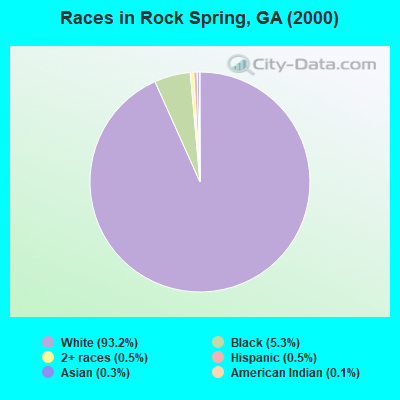
- 4,24293.2%White alone
- 2425.3%Black alone
- 240.5%Two or more races
- 210.5%Hispanic
- 150.3%Asian alone
- 60.1%American Indian alone
- 20.04%Native Hawaiian and Other
Pacific Islander alone - 10.02%Other race alone
Races in Rock Spring detailed stats: ancestries, foreign born residents, place of birth
According to our research of Georgia and other state lists, there were 19 registered sex offenders living in Rock Spring, Georgia as of May 23, 2024.
The ratio of all residents to sex offenders in Rock Spring is 253 to 1.
 Recent articles from our blog. Our writers, many of them Ph.D. graduates or candidates, create easy-to-read articles on a wide variety of topics.
Current Local Time: EST time zone
Elevation: 850 feet
Land area: 26.6 square miles.
Population density: 181 people per square mile (very low).

| Rock Spring CCD: | 0.6% ($445) |
| Georgia: | 0.9% ($919) |
Nearest city with pop. 50,000+: Chattanooga, TN  (16.6 miles , pop. 155,554).
Nearest city with pop. 200,000+: Atlanta, GA (86.8 miles , pop. 416,474).
Nearest city with pop. 1,000,000+: Chicago, IL (504.1 miles , pop. 2,896,016).
Nearest cities:
), ), ), )Latitude: 34.81 N, Longitude: 85.24 W
Area code commonly used in this area: 706

| Here: | 2.8% |
| Georgia: | 2.9% |
- Textile mills & textile products (11.3%)
- Health care (6.7%)
- Construction (6.3%)
- Finance & insurance (5.4%)
- Public administration (5.3%)
- Electrical equipment, appliances, components (5.1%)
- Educational services (4.5%)

- Textile mills & textile products (13.5%)
- Construction (11.0%)
- Public administration (7.3%)
- Metal & metal products (6.2%)
- Electrical equipment, appliances, components (5.5%)
- Administrative & support & waste management services (5.1%)
- Truck transportation (3.4%)
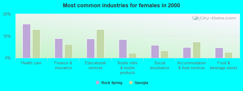
- Health care (15.4%)
- Finance & insurance (8.9%)
- Educational services (8.6%)
- Textile mills & textile products (8.4%)
- Social assistance (5.8%)
- Accommodation & food services (4.9%)
- Food & beverage stores (4.7%)
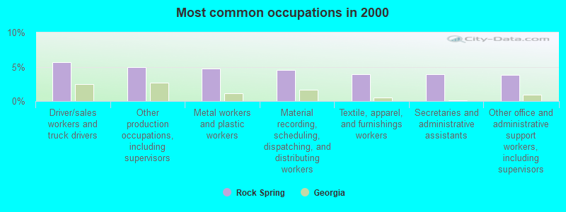
- Driver/sales workers and truck drivers (5.7%)
- Other production occupations, including supervisors (4.9%)
- Metal workers and plastic workers (4.7%)
- Material recording, scheduling, dispatching, and distributing workers (4.6%)
- Textile, apparel, and furnishings workers (3.9%)
- Secretaries and administrative assistants (3.9%)
- Other office and administrative support workers, including supervisors (3.8%)
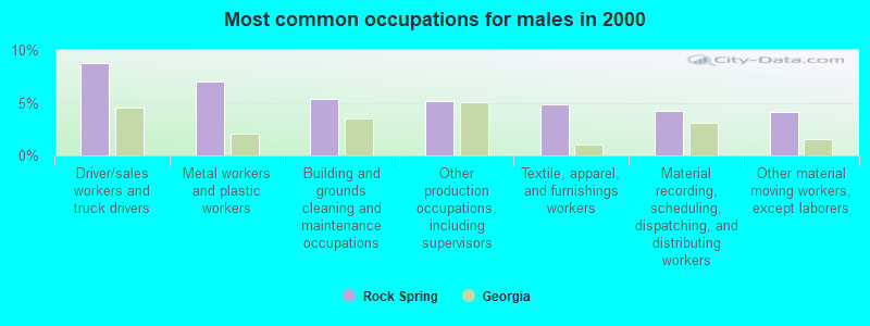
- Driver/sales workers and truck drivers (8.8%)
- Metal workers and plastic workers (7.0%)
- Building and grounds cleaning and maintenance occupations (5.4%)
- Other production occupations, including supervisors (5.1%)
- Textile, apparel, and furnishings workers (4.9%)
- Material recording, scheduling, dispatching, and distributing workers (4.3%)
- Other material moving workers, except laborers (4.2%)

- Secretaries and administrative assistants (9.0%)
- Other office and administrative support workers, including supervisors (8.7%)
- Bookkeeping, accounting, and auditing clerks (5.3%)
- Material recording, scheduling, dispatching, and distributing workers (5.0%)
- Other production occupations, including supervisors (4.7%)
- Registered nurses (4.2%)
- Laborers and material movers, hand (3.3%)
Average climate in Rock Spring, Georgia
Based on data reported by over 4,000 weather stations


(lower is better)
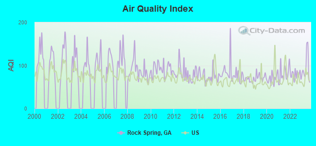
Air Quality Index (AQI) level in 2023 was 94.7. This is worse than average.
| City: | 94.7 |
| U.S.: | 72.6 |
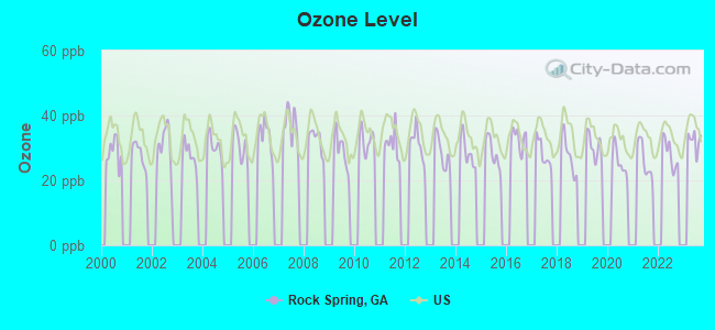
Ozone [ppb] level in 2023 was 32.3. This is about average. Closest monitor was 14.0 miles away from the city center.
| City: | 32.3 |
| U.S.: | 33.3 |
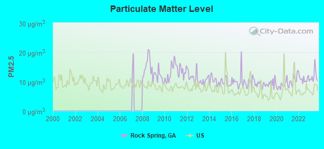
Particulate Matter (PM2.5) [µg/m3] level in 2023 was 11.9. This is significantly worse than average. Closest monitor was 12.3 miles away from the city center.
| City: | 11.9 |
| U.S.: | 8.1 |
Tornado activity:
Rock Spring-area historical tornado activity is slightly above Georgia state average. It is 63% greater than the overall U.S. average.
On 4/3/1974, a category F4 (max. wind speeds 207-260 mph) tornado 23.8 miles away from the Rock Spring place center killed 9 people and injured 67 people and caused between $500,000 and $5,000,000 in damages.
On 5/19/1973, a category F4 tornado 32.4 miles away from the place center injured 19 people and caused between $500,000 and $5,000,000 in damages.
Earthquake activity:
Rock Spring-area historical earthquake activity is significantly above Georgia state average. It is 109% greater than the overall U.S. average.On 4/29/2003 at 08:59:39, a magnitude 4.9 (4.4 MB, 4.6 MW, 4.9 LG, Class: Light, Intensity: IV - V) earthquake occurred 30.9 miles away from Rock Spring center
On 4/29/2003 at 08:59:39, a magnitude 4.6 (4.6 MW, Depth: 12.3 mi) earthquake occurred 31.0 miles away from the city center
On 11/30/1973 at 07:48:41, a magnitude 4.7 (4.7 MB, 4.6 ML) earthquake occurred 99.6 miles away from the city center
On 12/12/2018 at 09:14:43, a magnitude 4.4 (4.4 MW, Depth: 4.9 mi) earthquake occurred 62.7 miles away from the city center
On 8/2/1974 at 08:52:09, a magnitude 4.9 (4.3 MB, 4.9 LG) earthquake occurred 170.0 miles away from Rock Spring center
On 1/18/1999 at 07:00:53, a magnitude 4.8 (4.8 MB, 4.0 LG, Depth: 0.6 mi) earthquake occurred 150.7 miles away from the city center
Magnitude types: regional Lg-wave magnitude (LG), body-wave magnitude (MB), local magnitude (ML), moment magnitude (MW)
Natural disasters:
The number of natural disasters in Walker County (14) is near the US average (15).Major Disasters (Presidential) Declared: 9
Emergencies Declared: 4
Causes of natural disasters: Floods: 6, Storms: 5, Tornadoes: 5, Winter Storms: 4, Hurricanes: 2, Drought: 1, Snowfall: 1, Wind: 1, Other: 1 (Note: some incidents may be assigned to more than one category).
Hospitals and medical centers near Rock Spring:
- HERITAGE HEALTHCARE OF LAFAYETTE (Nursing Home, about 6 miles away; LAFAYETTE, GA)
- DCI LAFAYETTE (Dialysis Facility, about 8 miles away; LA FAYETTE, GA)
- HERITAGE HEALTHCARE AT SHEPHERD HILLS (Nursing Home, about 8 miles away; LA FAYETTE, GA)
- SHEPHERD HILLS HEALTH CARE CENTER (Nursing Home, about 8 miles away; LA FAYETTE, GA)
- COUNTRYSIDE HOSPICE CARE (Hospital, about 8 miles away; LAFAYETTE, GA)
- PARKSIDE AT HUTCHESON MED CTR (Nursing Home, about 10 miles away; ROSSVILLE, GA)
- NHC HEALTHCARE FT OGLETHORPE (Nursing Home, about 10 miles away; FORT OGLETHORPE, GA)
Colleges/universities with over 2000 students nearest to Rock Spring:
- Dalton State College (about 14 miles; Dalton, GA; Full-time enrollment: 3,846)
- The University of Tennessee-Chattanooga (about 18 miles; Chattanooga, TN; FT enrollment: 10,158)
- Southern Adventist University (about 20 miles; Collegedale, TN; FT enrollment: 2,898)
- Chattanooga State Community College (about 21 miles; Chattanooga, TN; FT enrollment: 6,827)
- Lee University (about 33 miles; Cleveland, TN; FT enrollment: 4,422)
- Cleveland State Community College (about 35 miles; Cleveland, TN; FT enrollment: 2,500)
- Berry College (about 36 miles; Mount Berry, GA; FT enrollment: 2,102)
Public elementary/middle schools in Rock Spring:
- WOODSTATION ELEMENTARY SCHOOL (Students: 465, Location: 3404 COLBERT HOLLOW RD, Grades: PK-5)
- ROCK SPRING ELEMENTARY SCHOOL (Students: 380, Location: 372 HIGHWAY 95, Grades: PK-5)
- SADDLE RIDGE ELEMENTARY AND MIDDLE SCHOOL (Location: 9858 N HIGHWAY 27, Grades: PK-8)
Points of interest:
Notable locations in Rock Spring: Walker Correctional Institute (A), Walker County Emergency Services Station 1 Rock Spring (B). Display/hide their locations on the map
Churches in Rock Spring include: Blessed Hope Mission (A), Grace Church (B), New Hope Church (C), Center Point Church (D), Center Grove Church (E), Peavine Church (F), Rock Spring United Methodist Church (G). Display/hide their locations on the map
Cemeteries: Lawrence Cemetery (1), McIntyre Cemetery (2), Center Point Cemetery (3), Crestlawn Memorial Park (4), Peavine Cemetery (5), Rock Spring Cemetery (6). Display/hide their locations on the map
Reservoirs: Whaley Lake (A), Shields Lake (B). Display/hide their locations on the map
Creek: Rock Spring Creek (A). Display/hide its location on the map
| This place: | 2.6 people |
| Georgia: | 2.6 people |
| This place: | 77.7% |
| Whole state: | 68.5% |
| This place: | 3.7% |
| Whole state: | 5.9% |
Likely homosexual households (counted as self-reported same-sex unmarried-partner households)
- Lesbian couples: 0.3% of all households
- Gay men: 0.2% of all households
| This place: | 7.2% |
| Whole state: | 13.0% |
| This place: | 2.8% |
| Whole state: | 6.1% |
People in group quarters in Rock Spring in 2010:
- 616 people in state prisons
- 14 people in group homes intended for adults
- 13 people in group homes for juveniles (non-correctional)
- 11 people in college/university student housing
- 10 people in nursing facilities/skilled-nursing facilities
5 people in homes for the mentally ill in 2000
Banks with branches in Rock Spring (2011 data):
- The Bank of La Fayette, Georgia: Rock Spring Branch at U.S. Highway 27 And Georgia Highway 95, branch established on 1985/10/10. Info updated 2006/06/15: Bank assets: $225.6 mil, Deposits: $191.5 mil, headquarters in La Fayette, GA, positive income, Mortgage Lending Specialization, 3 total offices, Holding Company: Lafayette Bankshares, Inc.
- Stearns Bank National Association: Covenant Bank & Trust Branch at 122 Highway 95, branch established on 2006/06/12. Info updated 2012/03/26: Bank assets: $1,174.7 mil, Deposits: $854.9 mil, headquarters in Saint Cloud, MN, positive income, Commercial Lending Specialization, 13 total offices, Holding Company: Stearns Financial Services, Inc. Employee Stock Ownership Plan
For population 15 years and over in Rock Spring:
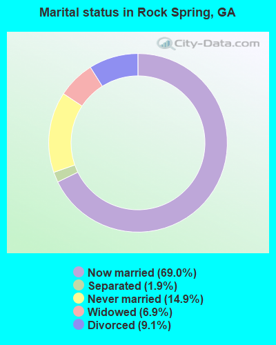
- Never married: 14.9%
- Now married: 69.0%
- Separated: 1.9%
- Widowed: 6.9%
- Divorced: 9.1%
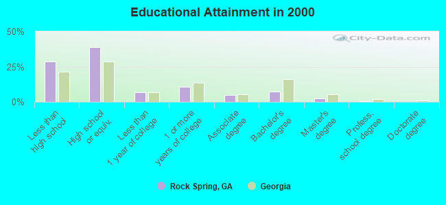
For population 25 years and over in Rock Spring:
- High school or higher: 71.5%
- Bachelor's degree or higher: 10.4%
- Graduate or professional degree: 3.3%
- Unemployed: 3.2%
- Mean travel time to work (commute): 30.9 minutes
| Here: | 12.2 |
| Georgia average: | 13.3 |
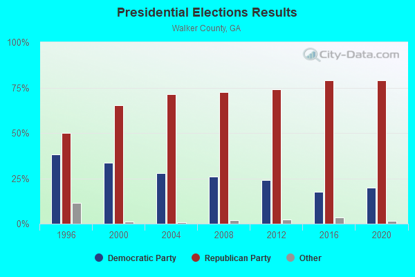
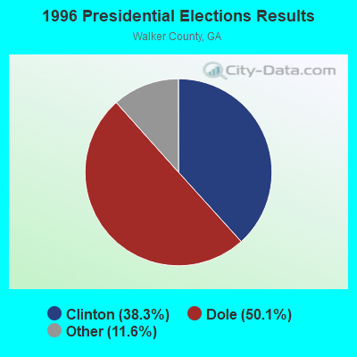
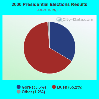

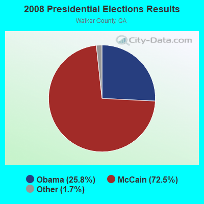
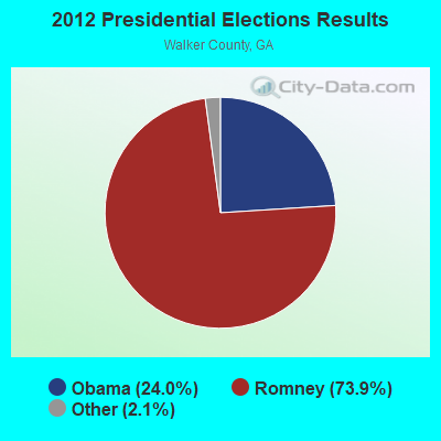

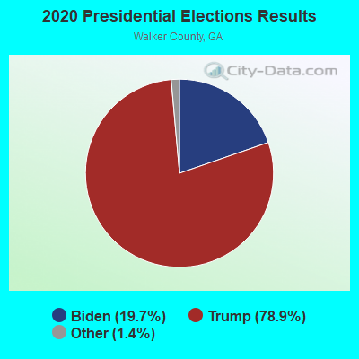
Graphs represent county-level data. Detailed 2008 Election Results
Religion statistics for Rock Spring, GA (based on Walker County data)
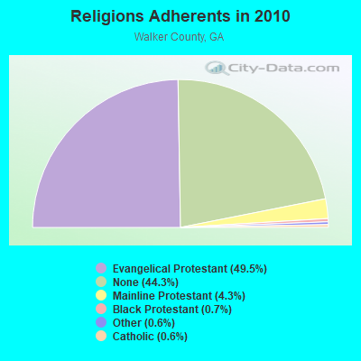
| Religion | Adherents | Congregations |
|---|---|---|
| Evangelical Protestant | 34,045 | 109 |
| Mainline Protestant | 2,948 | 16 |
| Black Protestant | 474 | 4 |
| Other | 419 | 3 |
| Catholic | 410 | 1 |
| None | 30,460 | - |
Food Environment Statistics:
| Walker County: | 1.71 / 10,000 pop. |
| State: | 1.91 / 10,000 pop. |
| This county: | 0.16 / 10,000 pop. |
| State: | 0.15 / 10,000 pop. |
| Here: | 1.09 / 10,000 pop. |
| Georgia: | 0.86 / 10,000 pop. |
| Walker County: | 5.74 / 10,000 pop. |
| Georgia: | 5.12 / 10,000 pop. |
| This county: | 3.57 / 10,000 pop. |
| Georgia: | 7.41 / 10,000 pop. |
| This county: | 11.7% |
| Georgia: | 10.4% |
| This county: | 28.4% |
| Georgia: | 27.8% |
| This county: | 12.0% |
| Georgia: | 14.6% |
Strongest AM radio stations in Rock Spring:
- WFLI (1070 AM; 50 kW; LOOKOUT MOUNTAIN, TN; Owner: WFLI, INC.)
- WQCH (1590 AM; 5 kW; LAFAYETTE, GA; Owner: RADIX BROADCASTING, INC.)
- WWAM (820 AM; daytime; 50 kW; JASPER, TN; Owner: SHELTON BROADCASTING SYSTEM)
- WTTI (1530 AM; daytime; 10 kW; DALTON, GA; Owner: PYE WILSON BROADCASTING, INC.)
- WQRX (870 AM; daytime; 10 kW; VALLEY HEAD, AL; Owner: BARINOWSKI INVESTMENT COMPANY)
- WNOO (1260 AM; 5 kW; CHATTANOOGA, TN; Owner: PYE BROADCASTING, INC.)
- WDEF (1370 AM; 5 kW; CHATTANOOGA, TN; Owner: JACKSON TELECASTERS, INC)
- WGOW (1150 AM; 5 kW; CHATTANOOGA, TN; Owner: CITADEL BROADCASTING COMPANY)
- WFTD (1080 AM; daytime; 50 kW; MARIETTA, GA; Owner: PRIETO ENTERPRISES, INC.)
- WNSI (810 AM; 50 kW; JACKSONVILLE, AL; Owner: UNITED BROADCASTING NETWORK, INC.)
- WCNN (680 AM; 50 kW; NORTH ATLANTA, GA; Owner: DICKEY BROADCASTING COMPANY)
- WGST (640 AM; 50 kW; ATLANTA, GA; Owner: CITICASTERS LICENSES, L.P.)
- WDOD (1310 AM; 5 kW; CHATTANOOGA, TN; Owner: WDOD OF CHATTANOOGA, INC.)
Strongest FM radio stations in Rock Spring:
- WBDX (102.7 FM; TRENTON, GA; Owner: PARTNERS FOR CHRISTIAN RADIO, INC.)
- WMBW (88.9 FM; CHATTANOOGA, TN; Owner: THE MOODY BIBLE INSTITUTE OF CHICAGO)
- W257AZ (99.3 FM; LOOKOUT MOUNTAIN, TN; Owner: CAPSTAR TX LIMITED PARTNERSHIP)
- WAWL-FM (91.5 FM; RED BANK, TN; Owner: CHATTANOOGA STATE TECHNICAL COMMUNITY COLLEGE)
- WMPZ (93.7 FM; RINGGOLD, GA; Owner: J.L. BREWER BROADCASTING, LLC)
- WUSY (100.7 FM; CLEVELAND, TN; Owner: CAPSTAR TX LIMITED PARTNERSHIP)
- W284AE (104.7 FM; ORCHARD HILLS, GA; Owner: WAY-FM MEDIA GROUP, INC.)
- WSGC-FM (101.9 FM; RINGGOLD, GA; Owner: CLEAR CHANNEL BROADCASTING LICENSES, INC.)
- WLOV-FM1 (97.3 FM; CHATTANOOGA, TN; Owner: CAPSTAR TX LIMITED PARTNERSHIP)
- W260AJ (99.9 FM; RINGGOLD, GA; Owner: WCCV)
- W241AF (96.1 FM; ROSSVILLE, GA; Owner: IMMANUEL BROADCASTING NETWORK, INC.)
- WDEF-FM (92.3 FM; CHATTANOOGA, TN; Owner: JACKSON TELECASTERS, INC.)
- WRXR-FM (105.5 FM; ROSSVILLE, GA; Owner: CAPSTAR TX LIMITED PARTNERSHIP)
- W234AG (94.7 FM; CHATSWORTH, GA; Owner: IMMANUEL BROADCASTING NETWORK, INC.)
- WQMT (98.9 FM; CHATSWORTH, GA; Owner: CLEAR CHANNEL BROADCASTING LICENSES, INC.)
- WDOD-FM (96.5 FM; CHATTANOOGA, TN; Owner: WDOD OF CHATTANOOGA, INC.)
- WSKZ (106.5 FM; CHATTANOOGA, TN; Owner: CITADEL BROADCASTING COMPANY)
- WKXJ (98.1 FM; SIGNAL MOUNTAIN, TN; Owner: CAPSTAR TX LIMITED PARTNERSHIP)
- WOGT (107.9 FM; EAST RIDGE, TN; Owner: CITADEL BROADCASTING COMPANY)
- W278AC (103.5 FM; WALDEN, TN; Owner: CAPSTAR TX LIMITED PARTNERSHIP)
TV broadcast stations around Rock Spring:
- WFLI-TV (Channel 53; CLEVELAND, TN; Owner: CHATTANOOGA MEDIA HOLDINGS, L.L.C.)
- WELF (Channel 23; DALTON, GA; Owner: TRINITY BROADCASTING NETWORK)
- WLFW-LP (Channel 41; LAFAYETTE, GA; Owner: NORTH GEORGIA TELEVISION)
- W66CG (Channel 66; ACTON, TN; Owner: MS COMMUNICATIONS, LLC)
- WDEF-TV (Channel 12; CHATTANOOGA, TN; Owner: MEDIA GENERAL COMMUNICATIONS, INC.)
- WDSI-TV (Channel 61; CHATTANOOGA, TN; Owner: WDSI LICENSE CORP.)
- WRCB-TV (Channel 3; CHATTANOOGA, TN; Owner: SARKES TARZIAN, INC.)
- WTCI (Channel 45; CHATTANOOGA, TN; Owner: THE GREATER CHATTANOOGA PUBLIC TELEVISION CORP)
- WRNG-LP (Channel 63; RINGGOLD, GA; Owner: NORTH GEORGIA TELEVISION)
- W35AA (Channel 35; La FAYETTE, GA; Owner: GEORGIA PUBLIC TELECOMMUNICATIONS COMMISSION)
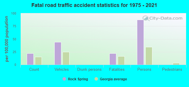
Rock Spring fatal accident list:
FCC Registered Antenna Towers:
13 (See the full list of FCC Registered Antenna Towers in Rock Spring)FCC Registered Broadcast Land Mobile Towers:
1- SADDLE RIDGE E., Lat: 34.845972 Lon: -85.249472, Call Sign: WQUQ637,
Assigned Frequencies: 467.212 MHz, Grant Date: 09/11/2014, Expiration Date: 09/11/2024, Certifier: Chris Jones, Registrant: Innovation Wireless, 5306 Beethoven St, Los Angeles, CA 90066, Phone: (888) 559-5565, Fax: (310) 482-3480, Email:
FCC Registered Microwave Towers:
3- Rock Springs GA 6, 321 Guy Williams Rd (Lat: 34.799500 Lon: -85.251361), Type: Tower, Structure height: 77.5 m, Overall height: 81.4 m, Call Sign: WQIW509,
Assigned Frequencies: 6315.84 MHz, Grant Date: 06/03/2008, Expiration Date: 06/03/2018, Cancellation Date: 12/03/2009, Certifier: William Chastain, Registrant: Radio Dynamics Corporation, Silver Spring, MD 20914, Phone: (301) 493-5171, Fax: (301) 576-4553, Email:
- ROCK SPRINGS, 8606 North Hwy 27 (Lat: 34.830556 Lon: -85.241667), Type: Tower, Structure height: 60.9 m, Call Sign: WQKG649,
Assigned Frequencies: 6315.84 MHz, Grant Date: 04/09/2019, Expiration Date: 05/12/2029, Cancellation Date: 01/03/2024, Certifier: Gregory M Romano, Registrant: Verizon, 5055 North Point Pkwy, Alpharetta, GA 30022, Phone: (770) 797-1070, Email:
- KNTYS00011A, 8864 N. Hwy 27 (Lat: 34.831417 Lon: -85.242583), Type: Mast, Structure height: 54.9 m, Overall height: 60.7 m, Call Sign: WRTQ495,
Assigned Frequencies: 11155.0 MHz, 11155.0 MHz, 11155.0 MHz, 11155.0 MHz, 11155.0 MHz, 11155.0 MHz, 11155.0 MHz, 11155.0 MHz, 11155.0 MHz, 11155.0 MHz, 11155.0 MHz, 11155.0 MHz, Grant Date: 07/13/2022, Expiration Date: 07/13/2032, Certifier: Alison A Minea, Registrant: Dish Wireless L.L.C., 9601 S Meridan Blvd, Englewood, CO 80112, Phone: (202) 463-3709, Email:
FCC Registered Paging Towers:
1- 0.5 Miles N. Of Rock Spring On Us Rt. 27 (Lat: 34.832000 Lon: -85.241611), Call Sign: WRV924,
Assigned Frequencies: 158.100 MHz, Expiration Date: 07/01/1998, Cancellation Date: 04/05/1999, Registrant: Chickamauga Telephone Corporation, Chickamauga, GA 30707
FCC Registered Amateur Radio Licenses:
34 (See the full list of FCC Registered Amateur Radio Licenses in Rock Spring)FAA Registered Aircraft:
2- Aircraft: PIPER PA-22-108 (Category: Land, Seats: 2, Weight: Up to 12,499 Pounds, Speed: 94 mph), Engine: LYCOMING 0-320 SERIES (180 HP) (Reciprocating)
N-Number: 4980Z, N4980Z, N-4980Z, Serial Number: 22-8588, Year manufactured: 1961, Airworthiness Date: 05/23/1961, Certificate Issue Date: 11/14/1995
Registrant (Individual): Charles Elliott, 186 Guy Williams Rd, Rock Spring, GA 30739 - Aircraft: CESSNA 172K (Category: Land, Seats: 4, Weight: Up to 12,499 Pounds, Speed: 105 mph), Engine: LYCOMING 0-320 SERIES (180 HP) (4 Cycle)
N-Number: 7422G, N7422G, N-7422G, Serial Number: 17259122, Year manufactured: 1970, Airworthiness Date: 11/06/1970, Certificate Issue Date: 07/03/2013
Registrant (Corporation): Lafayette Escadrille Flying Club, 778 Bicentennial Trl, Rock Spring, GA 30739
2002 - 2018 National Fire Incident Reporting System (NFIRS) incidents
- Fire incident types reported to NFIRS in Rock Spring, GA
- 31158.6%Outside Fires
- 14928.1%Structure Fires
- 5911.1%Mobile Property/Vehicle Fires
- 122.3%Other
 According to the data from the years 2002 - 2018 the average number of fire incidents per year is 31. The highest number of reported fires - 53 took place in 2007, and the least - 5 in 2005. The data has a declining trend.
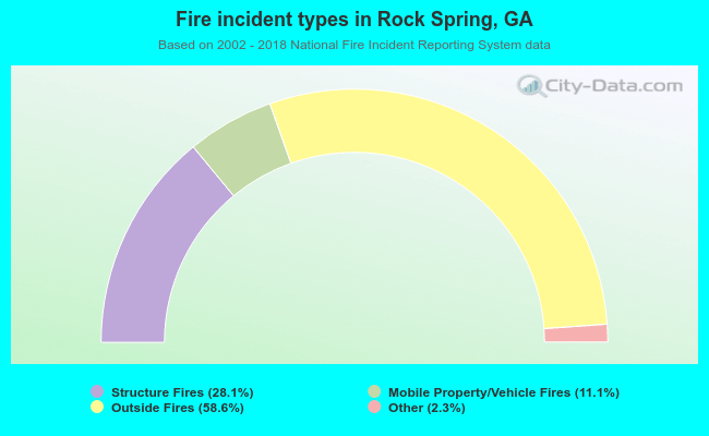 When looking into fire subcategories, the most reports belonged to: Outside Fires (58.6%), and Structure Fires (28.1%).
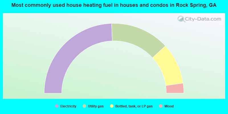
- 49.0%Electricity
- 27.4%Utility gas
- 19.1%Bottled, tank, or LP gas
- 4.6%Wood
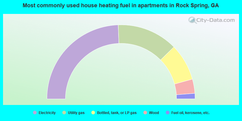
- 48.8%Electricity
- 26.5%Utility gas
- 16.1%Bottled, tank, or LP gas
- 6.2%Wood
- 2.4%Fuel oil, kerosene, etc.
Rock Spring compared to Georgia state average:
- Unemployed percentage significantly below state average.
- Black race population percentage significantly below state average.
- Hispanic race population percentage significantly below state average.
- Foreign-born population percentage significantly below state average.
- Renting percentage below state average.
- Length of stay since moving in significantly above state average.
- Number of rooms per house significantly below state average.
- House age significantly below state average.
- Institutionalized population percentage significantly above state average.
- Percentage of population with a bachelor's degree or higher below state average.

|
Total of 6 patent applications in 2008-2024.