Robbins Crossroads, Alabama
Submit your own pictures of this place and show them to the world
- OSM Map
- General Map
- Google Map
- MSN Map

| Males: 2,974 | |
| Females: 2,989 |
| Median resident age: | 37.1 years |
| Alabama median age: | 35.8 years |
Zip code: 35062
| Robbins Crossroads: | $62,292 |
| AL: | $59,674 |
Estimated per capita income in 2022: $35,967 (it was $19,034 in 2000)
Robbins Crossroads CCD income, earnings, and wages data
Estimated median house or condo value in 2022: $218,084 (it was $81,000 in 2000)
| Robbins Crossroads: | $218,084 |
| AL: | $200,900 |
Mean prices in 2022: all housing units: $309,295; detached houses: $322,061; townhouses or other attached units: $218,406; in 2-unit structures: $208,395; in 3-to-4-unit structures: $229,321; in 5-or-more-unit structures: $282,627; mobile homes: $67,878; occupied boats, rvs, vans, etc.: $104,744
Robbins Crossroads, AL residents, houses, and apartments details
Detailed information about poverty and poor residents in Robbins Crossroads, AL


- 5,85998.1%White alone
- 560.9%Two or more races
- 230.4%Hispanic
- 150.3%Black alone
- 100.2%American Indian alone
- 50.08%Asian alone
- 20.03%Native Hawaiian and Other
Pacific Islander alone

 Recent articles from our blog. Our writers, many of them Ph.D. graduates or candidates, create easy-to-read articles on a wide variety of topics.
Current Local Time: CST time zone
Elevation: 349 feet
Land area: 35.6 square miles.
Population density: 167 people per square mile (very low).

| Robbins Crossroads CCD: | 0.4% ($336) |
| Alabama: | 0.4% ($289) |
Nearest city with pop. 50,000+: Birmingham, AL  (18.0 miles , pop. 242,820).
Nearest city with pop. 1,000,000+: Chicago, IL (561.9 miles , pop. 2,896,016).
Nearest cities:
), ), ), ), )Latitude: 33.74 N, Longitude: 87.00 W
Area code commonly used in this area: 205


| Here: | 2.6% |
| Alabama: | 2.6% |

- Construction (8.4%)
- Educational services (8.4%)
- Health care (7.9%)
- Professional, scientific, technical services (6.4%)
- Truck transportation (6.2%)
- Metal & metal products (5.9%)
- Finance & insurance (5.8%)

- Construction (14.4%)
- Metal & metal products (10.0%)
- Truck transportation (9.0%)
- Public administration (6.7%)
- Professional, scientific, technical services (5.6%)
- Agriculture, forestry, fishing & hunting (4.5%)
- Repair & maintenance (3.9%)

- Educational services (16.0%)
- Health care (15.9%)
- Finance & insurance (12.7%)
- Professional, scientific, technical services (7.4%)
- Social assistance (4.9%)
- Food & beverage stores (4.6%)
- Public administration (3.7%)

- Driver/sales workers and truck drivers (8.3%)
- Other office and administrative support workers, including supervisors (4.5%)
- Electrical equipment mechanics and other installation, maintenance, and repair workers, including supervisors (4.5%)
- Secretaries and administrative assistants (3.6%)
- Building and grounds cleaning and maintenance occupations (3.5%)
- Other sales and related occupations, including supervisors (3.4%)
- Other production occupations, including supervisors (3.3%)

- Driver/sales workers and truck drivers (12.7%)
- Electrical equipment mechanics and other installation, maintenance, and repair workers, including supervisors (8.0%)
- Other production occupations, including supervisors (4.7%)
- Building and grounds cleaning and maintenance occupations (4.5%)
- Other sales and related occupations, including supervisors (4.2%)
- Metal workers and plastic workers (3.8%)
- Other material moving workers, except laborers (3.7%)

- Secretaries and administrative assistants (8.2%)
- Other office and administrative support workers, including supervisors (7.5%)
- Cashiers (5.0%)
- Information and record clerks, except customer service representatives (4.9%)
- Health technologists and technicians (4.8%)
- Child care workers (4.1%)
- Preschool, kindergarten, elementary, and middle school teachers (3.9%)
Average climate in Robbins Crossroads, Alabama
Based on data reported by over 4,000 weather stations


(lower is better)

Air Quality Index (AQI) level in 2022 was 82.0. This is about average.
| City: | 82.0 |
| U.S.: | 72.6 |

Carbon Monoxide (CO) [ppm] level in 2022 was 0.192. This is better than average. Closest monitor was 16.4 miles away from the city center.
| City: | 0.192 |
| U.S.: | 0.251 |

Nitrogen Dioxide (NO2) [ppb] level in 2022 was 8.54. This is significantly worse than average. Closest monitor was 16.4 miles away from the city center.
| City: | 8.54 |
| U.S.: | 5.11 |

Sulfur Dioxide (SO2) [ppb] level in 2022 was 0.254. This is significantly better than average. Closest monitor was 16.4 miles away from the city center.
| City: | 0.254 |
| U.S.: | 1.515 |

Ozone [ppb] level in 2022 was 28.8. This is about average. Closest monitor was 5.6 miles away from the city center.
| City: | 28.8 |
| U.S.: | 33.3 |

Particulate Matter (PM10) [µg/m3] level in 2022 was 19.1. This is about average. Closest monitor was 5.6 miles away from the city center.
| City: | 19.1 |
| U.S.: | 19.2 |

Particulate Matter (PM2.5) [µg/m3] level in 2022 was 7.99. This is about average. Closest monitor was 5.6 miles away from the city center.
| City: | 7.99 |
| U.S.: | 8.11 |

Tornado activity:
Robbins Crossroads-area historical tornado activity is slightly above Alabama state average. It is 166% greater than the overall U.S. average.
On 4/8/1998, a category F5 (max. wind speeds 261-318 mph) tornado 13.0 miles away from the Robbins Crossroads place center killed 32 people and injured 259 people and caused $200 million in damages.
On 4/4/1977, a category F5 tornado 15.4 miles away from the place center killed 22 people and injured 130 people and caused between $5,000,000 and $50,000,000 in damages.
Earthquake activity:
Robbins Crossroads-area historical earthquake activity is significantly above Alabama state average. It is 146% greater than the overall U.S. average.On 1/18/1999 at 07:00:53, a magnitude 4.8 (4.8 MB, 4.0 LG, Depth: 0.6 mi, Class: Light, Intensity: IV - V) earthquake occurred 27.2 miles away from Robbins Crossroads center
On 4/29/2003 at 08:59:39, a magnitude 4.9 (4.4 MB, 4.6 MW, 4.9 LG) earthquake occurred 94.4 miles away from Robbins Crossroads center
On 6/24/1975 at 11:11:36, a magnitude 4.5 (4.5 MB) earthquake occurred 48.4 miles away from Robbins Crossroads center
On 4/29/2003 at 08:59:39, a magnitude 4.6 (4.6 MW, Depth: 12.3 mi) earthquake occurred 94.3 miles away from Robbins Crossroads center
On 10/24/1997 at 08:35:17, a magnitude 4.9 (4.8 MB, 4.2 MS, 4.9 LG, Depth: 6.2 mi) earthquake occurred 181.4 miles away from the city center
On 12/12/1997 at 08:42:20, a magnitude 4.0 (3.9 MB, 4.0 LG, Depth: 0.6 mi) earthquake occurred 25.7 miles away from Robbins Crossroads center
Magnitude types: regional Lg-wave magnitude (LG), body-wave magnitude (MB), surface-wave magnitude (MS), moment magnitude (MW)
Natural disasters:
The number of natural disasters in Jefferson County (32) is a lot greater than the US average (15).Major Disasters (Presidential) Declared: 24
Emergencies Declared: 6
Causes of natural disasters: Storms: 18, Tornadoes: 16, Floods: 14, Hurricanes: 6, Winds: 6, Drought: 1, Fire: 1, Heavy Rain: 1, Snowfall: 1, Winter Storm: 1, Other: 1 (Note: some incidents may be assigned to more than one category).
Hospitals and medical centers near Robbins Crossroads:
- LONGVIEW GENERAL HOSPITAL (Hospital, about 7 miles away; GRAYSVILLE, AL)
- SOUTHEAST HOSPICE NETWORK, LLC (Hospital, about 11 miles away; JASPER, AL)
- CORDOVA HEALTH AND REHABILITATION, LLC (Nursing Home, about 11 miles away; CORDOVA, AL)
- FMC GARDENDALE (Dialysis Facility, about 12 miles away; GARDENDALE, AL)
- MAGNOLIA RIDGE CARE AND REHABILITATION CENTER (Nursing Home, about 14 miles away; GARDENDALE, AL)
- FMC FORESTDALE (Dialysis Facility, about 14 miles away; BIRMINGHAM, AL)
- BIRMINGHAM NURSING AND REHABILITATION CENTER (Nursing Home, about 15 miles away; BIRMINGHAM, AL)
Colleges/universities with over 2000 students nearest to Robbins Crossroads:
- Bevill State Community College (about 17 miles; Jasper, AL; Full-time enrollment: 2,970)
- Jefferson State Community College (about 18 miles; Birmingham, AL; FT enrollment: 6,041)
- University of Alabama at Birmingham (about 20 miles; Birmingham, AL; FT enrollment: 14,853)
- Lawson State Community College-Birmingham Campus (about 21 miles; Birmingham, AL; FT enrollment: 2,695)
- Virginia College-Birmingham (about 22 miles; Birmingham, AL; FT enrollment: 8,167)
- Samford University (about 23 miles; Birmingham, AL; FT enrollment: 3,829)
- George C Wallace State Community College-Hanceville (about 27 miles; Hanceville, AL; FT enrollment: 4,486)
Points of interest:
Notable location: Bagley Volunteer Fire and Rescue (A). Display/hide its location on the map
Churches in Robbins Crossroads include: New Temple Church (A), Bethel Church (B), Kilgore Church (C), Frog Ridge Church (D), Good Hope Church (E), Lawler Baptist Church (F), Snowtown Church (G), Liberty Church (H), Sayre Church (I). Display/hide their locations on the map
Cemeteries: Bagley Bend Cemetery (1), Lawler Cemetery (2), Adams Cemetery (3), Union Grove Cemetery (4), New Horizon Memorial Gardens (5). Display/hide their locations on the map
Reservoirs: Thornton Lake (A), Bentley Lake (B). Display/hide their locations on the map
Creeks: Mill Creek (A), Morgan Creek (B), Obes Creek (C). Display/hide their locations on the map
| This place: | 2.7 people |
| Alabama: | 2.5 people |
| This place: | 78.5% |
| Whole state: | 67.8% |
| This place: | 3.1% |
| Whole state: | 4.7% |
Likely homosexual households (counted as self-reported same-sex unmarried-partner households)
- Lesbian couples: 0.6% of all households
- Gay men: 0.2% of all households
| This place: | 9.4% |
| Whole state: | 16.1% |
| This place: | 2.6% |
| Whole state: | 7.3% |
For population 15 years and over in Robbins Crossroads:

- Never married: 15.9%
- Now married: 70.2%
- Separated: 1.1%
- Widowed: 7.0%
- Divorced: 6.9%
For population 25 years and over in Robbins Crossroads:
- High school or higher: 76.7%
- Bachelor's degree or higher: 10.7%
- Graduate or professional degree: 3.5%
- Unemployed: 1.8%
- Mean travel time to work (commute): 36.3 minutes


| Here: | 10.9 |
| Alabama average: | 13.2 |
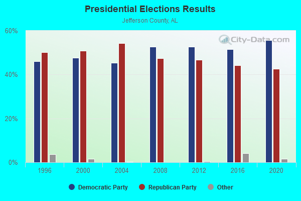
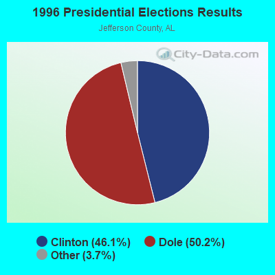
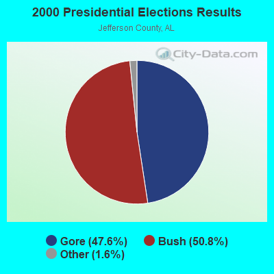
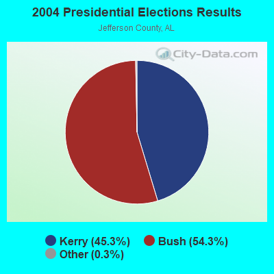
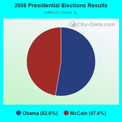
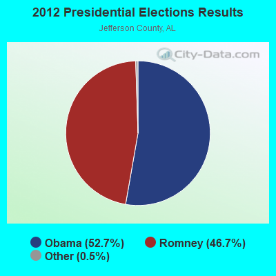
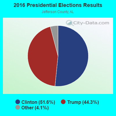
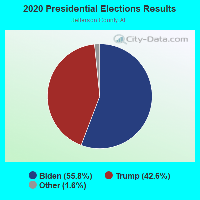
Graphs represent county-level data. Detailed 2008 Election Results
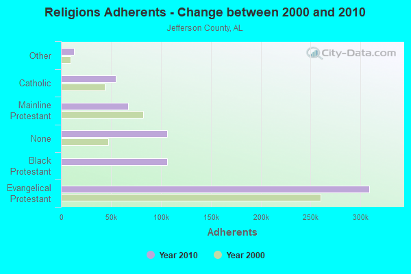
Religion statistics for Robbins Crossroads, AL (based on Jefferson County data)
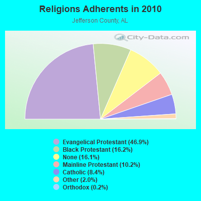
| Religion | Adherents | Congregations |
|---|---|---|
| Evangelical Protestant | 308,984 | 710 |
| Black Protestant | 106,653 | 257 |
| Mainline Protestant | 67,037 | 150 |
| Catholic | 55,083 | 32 |
| Other | 13,073 | 45 |
| Orthodox | 1,424 | 4 |
| None | 106,212 | - |
Food Environment Statistics:
| This county: | 2.05 / 10,000 pop. |
| Alabama: | 1.89 / 10,000 pop. |
| This county: | 0.18 / 10,000 pop. |
| Alabama: | 0.20 / 10,000 pop. |
| Jefferson County: | 0.99 / 10,000 pop. |
| State: | 0.65 / 10,000 pop. |
| Jefferson County: | 5.77 / 10,000 pop. |
| Alabama: | 6.32 / 10,000 pop. |
| Here: | 5.42 / 10,000 pop. |
| Alabama: | 5.75 / 10,000 pop. |
| This county: | 12.4% |
| Alabama: | 11.8% |
| Jefferson County: | 31.1% |
| Alabama: | 31.7% |
| Jefferson County: | 12.0% |
| State: | 13.5% |
6.20% of this county's 2020 resident taxpayers moved to other counties in 2021 ($76,918 average adjusted gross income)
| Here: | 6.20% |
| Alabama average: | 6.41% |
0.01% of residents moved to foreign countries ($73 average AGI)
Jefferson County: 0.01% Alabama average: 0.02%
Top counties to which taxpayers relocated from this county between 2020 and 2021:
| to Shelby County, AL | |
| to St. Clair County, AL | |
| to Blount County, AL |
Strongest AM radio stations in Robbins Crossroads:
- WAPI (1070 AM; 50 kW; BIRMINGHAM, AL; Owner: CITADEL BROADCASTING COMPANY)
- WDJC (850 AM; 50 kW; BIRMINGHAM, AL; Owner: KIMTRON, INC.)
- WJOX (690 AM; 50 kW; BIRMINGHAM, AL; Owner: CITADEL BROADCASTING COMPANY)
- WCOC (1010 AM; 5 kW; DORA, AL; Owner: AZTECA COMMUNICATIONS OF ALABAMA, INC.)
- WERC (960 AM; 5 kW; BIRMINGHAM, AL; Owner: CAPSTAR TX LIMITED PARTNERSHIP)
- WRJS (1320 AM; 5 kW; BIRMINGHAM, AL; Owner: CXR HOLDINGS, INC.)
- WNSI (810 AM; 50 kW; JACKSONVILLE, AL; Owner: UNITED BROADCASTING NETWORK, INC.)
- WYDE (1260 AM; 5 kW; BIRMINGHAM, AL; Owner: KIMTRON, INC.)
- WLPH (1480 AM; daytime; 5 kW; IRONDALE, AL; Owner: BIRMINGHAM CHRISTIAN RADIO, INC.)
- WLOR (1550 AM; 50 kW; HUNTSVILLE, AL; Owner: BCA RADIO, LLC)
- WATV (900 AM; 1 kW; BIRMINGHAM, AL)
- WKNG (1060 AM; daytime; 50 kW; TALLAPOOSA, GA; Owner: WKNG, INC.)
- WWAM (820 AM; daytime; 50 kW; JASPER, TN; Owner: SHELTON BROADCASTING SYSTEM)
Strongest FM radio stations in Robbins Crossroads:
- WBHK (98.7 FM; WARRIOR, AL; Owner: CXR HOLDINGS, INC.)
- WBPT (106.9 FM; BIRMINGHAM, AL; Owner: CXR HOLDINGS, INC.)
- WZZK-FM (104.7 FM; BIRMINGHAM, AL; Owner: CXR HOLDINGS, INC.)
- WDXB (102.5 FM; JASPER, AL; Owner: CAPSTAR TX LIMITED PARTNERSHIP)
- WODL (97.3 FM; HOMEWOOD, AL; Owner: CXR HOLDINGS, INC.)
- WRAX (107.7 FM; BIRMINGHAM, AL; Owner: CITADEL BROADCASTING COMPANY)
- WQOP-FM (92.5 FM; DORA, AL; Owner: QUEEN OF PEACE RADIO, INC.)
- WBHM (90.3 FM; BIRMINGHAM, AL; Owner: BD OF TRUSTEES/U OF AL AT BIRMINGHAM)
- WYSF (94.5 FM; BIRMINGHAM, AL; Owner: CITADEL BROADCASTING COMPANY)
- WYDE-FM (101.1 FM; CULLMAN, AL; Owner: KIMTRON, INC.)
- WMJJ (96.5 FM; BIRMINGHAM, AL; Owner: CAPSTAR TX LIMITED PARTNERSHIP)
- WQEN (103.7 FM; GADSDEN, AL; Owner: CAPSTAR TX LIMITED PARTNERSHIP)
- WZRR (99.5 FM; BIRMINGHAM, AL; Owner: CITADEL BROADCASTING COMPANY)
- WDJC-FM (93.7 FM; BIRMINGHAM, AL; Owner: KIMTRON, INC.)
- WBFR (89.5 FM; BIRMINGHAM, AL; Owner: FAMILY STATIONS, INC.)
- WENN (105.9 FM; TRUSSVILLE, AL; Owner: CAPSTAR TX LIMITED PARTNERSHIP)
- WFFN (95.3 FM; CORDOVA, AL; Owner: NEW CENTURY RADIO, INC.)
- WGIB (91.9 FM; BIRMINGHAM, AL; Owner: GLEN IRIS BAPTIST SCHOOL)
- W281AB (104.1 FM; MOUNTAIN BROOK, AL; Owner: FAMILY STATIONS, INC.)
- WLJR (88.5 FM; BIRMINGHAM, AL; Owner: BRIARWOOD PRESBYTERIAN CHURCH)
TV broadcast stations around Robbins Crossroads:
- WDBB (Channel 17; BESSEMER, AL; Owner: WDBB-TV, INC.)
- WCFT-TV (Channel 33; TUSCALOOSA, AL; Owner: TV ALABAMA, INCORPORATED)
- WIAT (Channel 42; BIRMINGHAM, AL; Owner: MEDIA GENERAL COMMUNICATIONS, INC.)
- WBIQ (Channel 10; BIRMINGHAM, AL; Owner: ALABAMA EDUCATIONAL TELEVISION COMMISSION)
- W23AK (Channel 23; JASPER, AL; Owner: WMTY, INC.)
- WTTO (Channel 21; HOMEWOOD, AL; Owner: WTTO LICENSEE, LLC)
- WBRC (Channel 6; BIRMINGHAM, AL; Owner: WBRC LICENSE, INC.)
- WABM (Channel 68; BIRMINGHAM, AL; Owner: BIRMINGHAM (WABM-TV) LICENSEE, INC.)
- WVTM-TV (Channel 13; BIRMINGHAM, AL; Owner: BIRMINGHAM BROADCASTING (WVTM-TV), LLC)
- WBXA-CA (Channel 2; BIRMINGHAM, AL; Owner: THE BOX WORLDWIDE LLC)
- W46DK (Channel 46; BIRMINGHAM, AL; Owner: TRINITY BROADCASTING NETWORK)
- W27CM (Channel 27; BIRMINGHAM, AL; Owner: EQUITY BROADCASTING CORPORATION)
- W55BJ (Channel 55; JASPER, AL; Owner: COMBS BROADCASTING, INC.)
- W66CN (Channel 66; JASPER, AL; Owner: TRINITY BROADCASTING NETWORK)
- WBMA-LP (Channel 58; BIRMINGHAM, AL; Owner: TV ALABAMA, INC.)
- WTJP (Channel 60; GADSDEN, AL; Owner: TRINITY BROADCASTING NETWORK)
- W34BI (Channel 34; BIRMINGHAM, AL; Owner: VENTANA TELEVISION, INC.)

- 68.3%Electricity
- 19.9%Bottled, tank, or LP gas
- 10.9%Utility gas
- 1.0%Wood

- 39.3%Electricity
- 37.6%Bottled, tank, or LP gas
- 23.1%Utility gas
Robbins Crossroads compared to Alabama state average:
- Unemployed percentage significantly below state average.
- Black race population percentage significantly below state average.
- Hispanic race population percentage significantly below state average.
- Median age below state average.
- Foreign-born population percentage significantly below state average.
- Renting percentage significantly below state average.
- Length of stay since moving in significantly above state average.
- Number of rooms per house significantly below state average.
- House age significantly below state average.
- Percentage of population with a bachelor's degree or higher below state average.
Robbins Crossroads on our top lists:
- #2 on the list of "Top 101 cities with largest percentage of females in occupations: bus drivers (population 5,000+)"
- #2 on the list of "Top 101 cities with largest percentage of males in industries: truck transportation (population 5,000+)"
- #3 on the list of "Top 101 cities with largest percentage of males in occupations: driver/sales workers and truck drivers (population 5,000+)"
- #3 on the list of "Top 101 cities with largest percentage of males in occupations: rail and water transportation workers (population 5,000+)"
- #4 on the list of "Top 101 cities with largest percentage of females in occupations: driver/sales workers and truck drivers (population 5,000+)"
- #14 on the list of "Top 101 cities with largest percentage of females in occupations: printing workers (population 5,000+)"
- #14 on the list of "Top 101 cities with largest percentage of females in occupations: occupational and physical therapist assistants and aides (population 5,000+)"
- #16 on the list of "Top 101 cities with largest percentage of females in industries: truck transportation (population 5,000+)"
- #18 on the list of "Top 101 cities with largest percentage of males in industries: rail transportation (population 5,000+)"
- #22 on the list of "Top 101 cities with largest percentage of males in industries: metal and metal products (population 5,000+)"
- #28 on the list of "Top 101 cities with largest percentage of females in industries: printing and related support activities (population 5,000+)"
- #31 on the list of "Top 100 least racially diverse cities (pop. 5,000+)"
- #46 on the list of "Top 101 cities with largest percentage of males in industries: petroleum and petroleum products merchant wholesalers (population 5,000+)"
- #53 on the list of "Top 101 cities with largest percentage of males in industries: machinery, equipment, and supplies merchant wholesalers (population 5,000+)"
- #54 on the list of "Top 101 cities with largest percentage of males in industries: groceries and related products merchant wholesalers (population 5,000+)"
- #55 on the list of "Top 101 cities with largest percentage of females in industries: utilities (population 5,000+)"
- #65 on the list of "Top 101 cities with largest percentage of females in industries: machinery, equipment, and supplies merchant wholesalers (population 5,000+)"
- #67 on the list of "Top 101 cities with largest percentage of males in industries: printing and related support activities (population 5,000+)"
- #73 on the list of "Top 101 cities with largest percentage of females in industries: religious, grantmaking, civic, professional, and similar organizations (population 5,000+)"
- #74 on the list of "Top 101 cities with largest percentage of females in industries: health and personal care, except drug, stores (population 5,000+)"
- #5 on the list of "Top 101 counties with the highest number of infant deaths per 1000 residents 2007-2013 (pop. 50,000+)"
- #5 on the list of "Top 101 counties with the most Black Protestant adherents"
- #5 on the list of "Top 101 counties with the most Black Protestant congregations"
- #9 on the list of "Top 101 counties with the highest average weight of females"
- #9 on the list of "Top 101 counties with the most Evangelical Protestant adherents"